Troldborg Ring
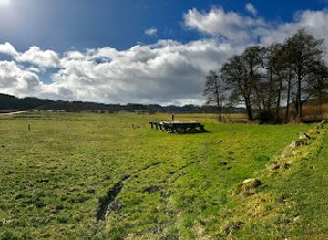
Iron Age refuge fortress on a wooded hilltop, where grassy ramparts, “Devil’s Valley” slopes and wide views over Vejle Ådal bring deep Danish history to life.
Troldborg Ring is an Iron Age ring fort dramatically perched 70 metres above the Vejle River Valley near Bredsten in Jutland. Encircled by a 60-metre-wide rampart and moat, this refuge fortress from around 100–200 AD once offered local communities protection in troubled times. Today, grassy earthworks, steep slopes nicknamed “Fandens dal” and sweeping views over the valley combine archaeology and nature into a compact, atmospheric walk in Ladegårdsskoven.
A brief summary to Troldborg Ring
- Bredsten, 7182, DK
- Visit website
- Duration: 0.5 to 2 hours
- Free
-
Outdoor
- Mobile reception: 3 out of 5
Local tips
- Wear sturdy shoes: the approach includes an uphill forest walk and the slopes around the ring can be muddy and slippery after rain.
- Bring water and snacks, as there are no services or kiosks at the monument itself and only basic facilities near the parking area.
- Combine your visit with nearby Ravning Bridge or Jelling’s monuments to connect Troldborg Ring’s Iron Age story with later Viking history.
- Visit on a clear day or around golden hour to make the most of the views over the Vejle River Valley from the edge of the ramparts.
For the on-the-go comforts that matter to you
- Information Boards
- Trash Bins
- Seating Areas
Getting There
-
Car from Vejle
From central Vejle, driving to the Troldborg Ring parking area near Ravning typically takes about 20–30 minutes depending on traffic. The route follows paved regional roads through rolling countryside. Parking at the forest edge is free but limited to a small gravel area, and from there you continue on foot along forest tracks to the site. In winter or after heavy rain, expect muddy sections on the final approach and allow extra time for a careful walk.
-
Bus and short hike from Vejle area
Regional buses connect Vejle with villages near Bredsten and Ravning in about 25–40 minutes, with services generally hourly on weekdays and less frequent in the evening and on weekends. A standard adult ticket on local buses in this part of Jutland typically costs around 20–40 DKK depending on zones. From the nearest bus stop, you should be prepared to walk on rural roads and forest paths for 30–45 minutes to reach the Troldborg Ring trailhead, so this option suits visitors comfortable with longer walks and basic wayfinding.
-
Cycling from Bredsten or nearby villages
For confident cyclists, Troldborg Ring can be combined with a countryside ride from Bredsten or other nearby villages, usually taking 20–40 minutes each way on gently hilly rural roads. Surfaces are mostly paved, though the final stretch to the parking area and the approach through the forest are on gravel or dirt tracks where you may prefer to push your bike. There are no formal bike racks, so bring a lock and be ready to secure your bicycle discreetly near the forest edge without blocking paths or access.
Troldborg Ring location weather suitability
-
Clear Skies
-
Mild Temperatures
-
Any Weather
-
Cold Weather
-
Hot Weather
Discover more about Troldborg Ring
Iron Age stronghold above the Vejle River Valley
Troldborg Ring crowns a wooded hilltop in Ladegårdsskoven, just south of Bredsten and Ravning, where the land drops steeply into the Vejle River Valley. Archaeologists interpret it as a refuge fortress from the early Iron Age, most likely around 100–200 AD, when rival tribes contested control of Jutland. Raised earth banks and a surrounding ditch trace a near-perfect ring, enclosing a protected space that once gathered people, livestock and valuables in moments of danger. From the outside, the monument looks surprisingly modest: a low, circular ridge overgrown with grass and heather. Step onto the ring, however, and the geometry becomes clear. The fort’s diameter is about 60 metres, forming a compact enclosure that could be defended by a relatively small group. Although no buildings are visible today, the earthworks are the enduring skeleton of a much busier fortified refuge.Earthworks shaped by defence and landscape
The builders of Troldborg Ring chose their site with care. On one side, a man-made rampart and moat block access along the ridge; on the others, the hill falls away so abruptly that the deep gully below is known as “Fandens dal” – the Devil’s Valley. Together, natural slopes and artificial banks created a defensive shell that would have been difficult to storm with Iron Age weapons. Within the enclosure, the ground is gently undulating, suggesting terraces where temporary shelters or storage structures might once have stood. Just beyond the fort, springs and the fertile valley floor offered water, pasture and fields. The ring thus sits at the meeting point between secure retreat and productive landscape, an elevated control post watching over movement along the valley long before later rulers imposed their authority here.From tribal frontier to royal heartland
Troldborg Ring belongs to a time centuries before the famous Viking kings of Jelling, yet it hints at an earlier phase of power in the Vejle region. The Iron Age saw repeated conflicts between local groups, reflected in fortified sites, weapon deposits in nearby bogs and carefully positioned strongholds like this one. Standing on the rampart, it is easy to imagine lookouts scanning for smoke, riders or war bands threading the valley below. Much later, in the late 10th century, the same strategic corridor attracted the attention of Harald Bluetooth, who built the great Ravning Bridge across the valley just downstream. That monumental timber structure turned the area into part of a royal communications and military network. In this way, Troldborg Ring forms one chapter in a long story of how geography shaped political and military decisions in eastern Jutland.A quiet woodland walk through deep time
Today, reaching Troldborg Ring involves a short walk along forest tracks through Ladegårdsskoven, emerging at the clearing where the ring crowns the slope. Birds call from the trees, the wind catches in the canopy, and the hum of modern life fades. The rampart is now a soft green curve, inviting you to stroll its length and feel the change in perspective as you circle above the valley. The views are one of the site’s great rewards. Between the trees, openings frame the Vejle River Valley, farmland patches and, on clear days, the line where the valley continues toward Vejle Fjord. The combination of archaeological structure and scenic landscape makes Troldborg Ring as much an outdoor viewpoint as a historic monument, best appreciated at an unhurried pace.Practical details and ways to explore
Troldborg Ring is protected but freely accessible, set on private land with a right of public access. A small parking area near the forest edge offers information about the monument and the surrounding nature, from where a modest uphill walk leads to the fort. Simple paths and unpaved surfaces mean sturdy footwear is advisable, especially in wet weather when slopes can be slippery. There are no built facilities at the ring itself, so visitors should bring water and any snacks they need. Many choose to combine the site with other ancient and Viking Age locations in the area, such as Ravning Bridge or the Jelling complex, creating a day that spans more than a thousand years of Danish history within the Vejle landscape. Even a short visit, though, is enough to sense how this small circle of earth once anchored a community in uncertain times.For the vibe & atmosphere seeker
- Tranquil
- Scenic
- Adventurous
- Unique
- Relaxing
For the design and aesthetic lover
- Rustic Designs
For the architecture buff
- Historic
- Landmarks
- Viewpoints
- Parks & Gardens
For the view chaser and sunset hunter
- Iconic Views
- Panoramas
- Sunset Spots
For the social media creator & influencer
- Photo Spots
- Selfie Spots
- Architectural Shots
- Reel-Friendly
For the eco-conscious traveler
- Low Impact
- Public-Transport Accessible
- Leave-No-Trace Critical
- Locally Managed
For the kind of experience you’re after
- Cultural Heritage
- Photowalk
- Nature Escape
- Roadtrip Stop
- Day Trip
- Mindfulness
For how adventurous you want the journey to be
- Requires Hike
- Easy Access
Location Audience
- Family Friendly
- Senior Friendly
- Child Friendly
- Teen Friendly
- Solo Friendly
- Couple Friendly
- Solo Female Friendly
- LGBT Friendly