

Etosha National Park Travel Guide - Free Web & App
Your ultimate guide to Etosha National Park. Discover top landmarks, proposed trips, and local tips. Free on the web or via the Evendo companion app.


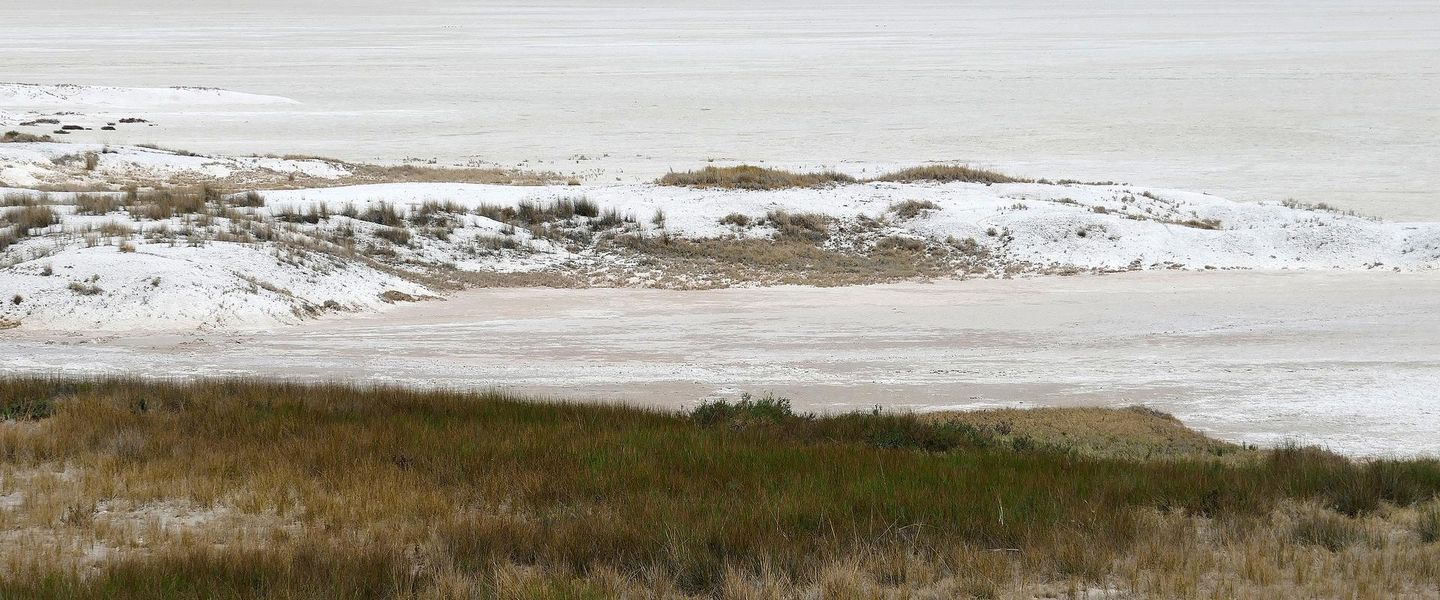


Etosha National Park in Namibia offers vast salt-pan scenery, waterhole safaris, elephants, rhinos, big cats and exceptional dry-season wildlife viewing.
The Landscape of Etosha
Etosha National Park occupies a vast area of northern Namibia, centred on the Etosha Pan, a pale, almost motionless expanse that gives the park its name. The pan is the remnant of a much larger ancient lake and is usually dry, although seasonal rains can transform sections of it into shallow water and attract large numbers of birds. Around it lie open grasslands, mopane woodland, thorn scrub and scattered waterholes, creating a landscape in which wildlife is often visible across considerable distances.Read more about Etosha National Park
Wildlife and Waterholes
History and Conservation
When is the best time to visit Etosha National Park?
Best: May–July · 25–28°C| Month | High (°C) | Rainfall (mm) |
|---|---|---|
| January | 34 | 0 |
| February | 34 | 0 |
| March | 32 | 0 |
| April | 32 | 0 |
| May (best) | 28 | 0 |
| June (best) | 25 | 0 |
| July (best) | 25 | 0 |
| August | 29 | 0 |
| September | 33 | 0 |
| October | 37 | 0 |
| November | 36 | 0 |
| December | 37 | 0 |
Getting to and around Etosha National Park
How to get there
Transportation
Best attractions in Etosha National Park
Etosha’s principal attraction is the Etosha Pan, a vast white depression whose scale becomes clearest from the surrounding open plains and viewpoints along the park roads. Wildlife viewing centres on a chain of natural and managed waterholes, including the well-known Okaukuejo waterhole, where animals may gather during dry periods. The southern area around Okaukuejo combines grassland and thornveld, while the central region near Halali includes rocky country and denser vegetation. Around Namutoni, eastern waterholes and woodland support varied game viewing, and the western section offers a quieter route through changing habitats. Elephants, giraffes, zebra, wildebeest, springbok, gemsbok and black rhinoceros are among the animals visitors may encounter, with lions, cheetahs and hyenas also present. Birdlife is especially varied after rain and when water reaches parts of the pan. The camps themselves provide useful bases for exploring the surrounding road network rather than attractions separate from the park’s wider landscape.
-
Tourist attraction
Okaukuejo Etosha
Explore the enchanting wildlife and stunning landscapes of Okaukuejo in Etosha National Park, a perfect getaway for nature lovers and wildlife enthusiasts.
-
National park
Moringa Waterhole Viewpoint
Discover the stunning Moringa Waterhole Viewpoint in Halali, Namibia, where wildlife and breathtaking landscapes await every traveler.
-
Tourist attraction
Chudop Waterhole
Experience the serene beauty of Chudop Waterhole in Etosha National Park, a haven for wildlife enthusiasts and nature lovers alike.
-
Tourist attraction
Anderson Gate Etosha National Park (Southern Entrance)
Explore the enchanting wildlife and breathtaking landscapes at Anderson Gate, the southern entrance to Etosha National Park in Namibia.


Best landmarks in Etosha National Park
The Etosha Pan is the park’s defining natural landmark, a broad saline depression whose pale surface contrasts with the grassland and woodland around it. Its size and flatness are particularly striking from the surrounding roads, although access onto the pan itself is restricted to permitted areas. Okaukuejo waterhole is both a wildlife focal point and an important symbol of the park’s visitor experience, while Halali and Namutoni mark central and eastern bases within the protected area. Namutoni’s former German fort is a prominent built landmark, reflecting the region’s colonial military and administrative history. Dolomite Camp and the western landscapes introduce a more rugged character, with rocky outcrops and changing vegetation distinguishing this part of Etosha from the open southern plains. The park’s network of waterholes, pan margins, camps and long gravel roads together forms a cultural landscape as much as a collection of isolated sights.
-
Lodge
Etosha Safari Camp, Gondwana Collection Namibia
Experience the thrill of wildlife adventures at Etosha Safari Camp, your gateway to Namibia's stunning landscapes and rich biodiversity.
-
Tourist attraction
Okaukuejo Etosha
Experience the wildlife wonders of Okaukuejo Etosha, where adventure meets serenity in Namibia's breathtaking landscapes.
-
Lodge
Etosha Safari Lodge, Gondwana Collection Namibia
Experience the beauty of Namibia at Etosha Safari Lodge, your premier accommodation for exploring Etosha National Park's wildlife and landscapes.
-
National park
Etosha Village
Experience the beauty of wildlife and nature at Etosha Village, your gateway to Etosha National Park's stunning landscapes and vibrant ecosystems.


Explore Etosha National Park on the map
Plan your trip on one map. See where the top attractions, landmarks, restaurants and hotels are, and book hotels and experiences in a few clicks.
Best hotels in Etosha National Park
Best restaurants in Etosha National Park
Dining in Etosha is concentrated at the main rest camps and at lodges and guest farms outside the park rather than spread through a conventional restaurant scene. Okaukuejo, Halali and Namutoni provide the principal in-park food facilities, while private lodges near the southern, eastern, western and northern approaches generally offer meals to their guests. Outside the boundaries, towns such as Outjo, Tsumeb and Grootfontein provide additional restaurants, cafés and supermarkets for provisions. Food commonly reflects Namibian and southern African influences, with meat, grilled dishes, stews, vegetables and game-related produce appearing in different forms, alongside familiar continental options for safari travellers. Roadside and town shopping is useful for water, packed lunches and snacks, since visitors travelling between distant waterholes should not expect cafés or food outlets. Lodge dining may be arranged for residents, and advance checking is sensible for non-resident visitors seeking meals near park gates.
-
 National park
Etosha National Park
Explore Etosha National Park: A Wildlife Haven with Stunning Landscapes and Diverse Fauna Awaiting Your Discovery.
-
Lodge
Etosha Safari Camp, Gondwana Collection Namibia
Experience unparalleled wildlife adventures at Etosha Safari Camp while immersing yourself in Namibia's breathtaking landscapes.
-
Lodge
Etosha Safari Lodge, Gondwana Collection Namibia
Experience unparalleled wildlife adventures at Etosha Safari Lodge, your gateway to Namibia's stunning landscapes and vibrant ecosystems.
-
National park
Etosha Village
Experience the beauty and tranquility of Etosha Village - your gateway to exploring Namibia's stunning wildlife and landscapes.


Best bars in Etosha National Park
Etosha has no conventional nightlife district, and evenings are shaped by the rhythm of the bush rather than by clubs or late-opening bars. The main rest camps and surrounding lodges may provide licensed bars or informal areas where guests discuss the day’s sightings, but facilities and opening arrangements vary. After dark, the waterhole at Okaukuejo is a recognised setting for quiet wildlife observation when conditions and park rules permit, with visitors expected to remain in the designated area and avoid disturbing animals. Outside the park, lodges, guest farms and country establishments near Outjo, Tsumeb, Grootfontein and other approach routes offer a more social evening atmosphere, although entertainment remains modest. Cultural performances, fireside gatherings or seasonal events may occur at individual properties without forming a permanent public programme, so Etosha is best approached as an early-start safari destination rather than a late-night one.
-
Restaurant
Halali Camp Restaurant
Discover the flavors of Namibia at Halali Camp Restaurant, nestled within the breathtaking Etosha National Park.
-
Bar
Tabito Bar
Experience the lively spirit of Omuthiya at Tabito Bar – where great drinks and local culture come together!
-
Grill
Matimkwetu Bar
Experience authentic Namibian cuisine at Matimkwetu Bar, where local flavors and vibrant culture come together in a lively atmosphere.
-
Bar
Spotman Bar
Experience the vibrant nightlife of Onashikookaya at Spotman Bar, where local flavors and energetic ambiance come together for an unforgettable evening.


Best nightclubs in Etosha National Park
Etosha has no conventional nightlife district, and evenings are shaped by the rhythm of the bush rather than by clubs or late-opening bars. The main rest camps and surrounding lodges may provide licensed bars or informal areas where guests discuss the day’s sightings, but facilities and opening arrangements vary. After dark, the waterhole at Okaukuejo is a recognised setting for quiet wildlife observation when conditions and park rules permit, with visitors expected to remain in the designated area and avoid disturbing animals. Outside the park, lodges, guest farms and country establishments near Outjo, Tsumeb, Grootfontein and other approach routes offer a more social evening atmosphere, although entertainment remains modest. Cultural performances, fireside gatherings or seasonal events may occur at individual properties without forming a permanent public programme, so Etosha is best approached as an early-start safari destination rather than a late-night one.
-
Tourist attraction
Okaukuejo Etosha
Explore Okaukuejo: A Wildlife Haven in Etosha National Park with Stunning Nighttime Waterhole Experiences
-
Campground
Halali Camp
Immerse yourself in nature at Halali Camp, the ultimate campground in Etosha National Park for wildlife viewing and adventure.
-
Campground
Namutoni Camp (Camping Area)
Explore the heart of Namibian wildlife at Namutoni Camp in Etosha National Park, where adventure and nature await.
-
Inn
Emanya@Etosha Game Lodge
Discover the wonders of wildlife and luxury at Emanya@Etosha Game Lodge, your gateway to Namibia's breathtaking nature.


Best shops in Etosha National Park
Shopping within Etosha is limited and practical, with camp shops and reception areas generally focused on drinks, snacks, basic supplies, souvenirs and safari-related necessities rather than extensive retail. More substantial provisioning is available in gateway towns such as Outjo, Tsumeb and Grootfontein, where supermarkets, fuel stations and independent businesses serve both local communities and travellers. Namibia is known for crafts including carved wood, woven goods, textiles, jewellery and decorative items, but stock and authenticity vary, so buyers should favour reputable outlets and ask about sustainably sourced materials. Regional farm shops and roadside sellers may offer local food products outside the park, though availability is seasonal and not guaranteed. Visitors should obtain fuel, water, sun protection and other essentials before entering remote sections, since the park’s camps cannot be treated as full-service shopping centres.
-
National park
Etosha National Park
Experience the majestic wildlife and stunning landscapes of Etosha National Park, a premier destination for safari adventures in Namibia.
-
Lodge
Etosha Safari Camp, Gondwana Collection Namibia
Discover the thrill of wildlife adventures at Etosha Safari Camp, your gateway to Namibia's stunning Etosha National Park.
-
Tourist attraction
Okaukuejo Etosha
Experience the wildlife wonder at Okaukuejo in Etosha National Park, where breathtaking views and vibrant nature await every traveler.
-
Lodge
Etosha Safari Lodge, Gondwana Collection Namibia
Experience the magic of Namibia at Etosha Safari Lodge, where comfort meets adventure in the heart of nature's bounty.


Get your free copy of our complete guide to Etosha National Park, delivered straight to you.
Everything on this page, from attractions and restaurants to essentials and local phrases, in one PDF you can read offline, print or share.
Already have an account? Sign in
Your Etosha National Park guide is ready.
We'll send it to · Not you? Sign out

Getting your guide ready…
We are putting together a fresh copy of the Etosha National Park guide. This can take up to a minute.
This can take a few moments. If your browser asks, choose Allow so the download can start. You'll find the guide in your Downloads folder.
Nothing happened? Download it again
Sorry, the guide is taking longer than usual. Please try again in a minute, or get it by email instead.
Etosha National Park essentials
Currency and Payment
Safety
Emergency Situations
Do's and Don'ts
Local Tips
From Eve
Local phrases worth knowing
You don't need to get them perfect. A few words go a long way, and locals appreciate the effort.
Basics
| English | Local | Say it |
|---|---|---|
| Hello | Moro | [Maw-roh] |
| Goodbye | Tashi kuka | [Tah-shee koo-kah] |
| Yes | Ehe | [Eh-heh] |
| No | Awe | [Ah-way] |
| Please/You're welcome | Kameme | [Kah-meh-meh] |
| Thank you | Ondonga | [On-dong-gah] |
| Excuse me/Sorry | Eshike | [Eh-shee-kay] |
| How are you? | Ondi lala? | [On-dee lah-lah] |
| Fine. And you? | Ne nandi. Ondi lala? | [Neh nan-dee. On-dee lah-lah] |
| Do you speak English? | Ondi shiingira onkala? | [On-dee shee-een-gee-rah on-kah-lah] |
| I don't understand | Aha sha onga | [Ah-hah shah on-gah] |
Eating & Drinking
| English | Local | Say it |
|---|---|---|
| I'd like to see the menu, please | Ondi lela oshilumbi, kameme | [On-dee leh-lah oh-shee-loo-mbee, kah-meh-meh] |
| I don't eat meat | Aha sha longa omahangu | [Ah-hah shah lohn-gah oh-mah-hahn-goo] |
| Cheers! | Ombwala! | [Ohm-bwah-lah] |
| I would like to pay, please | Ondi lala okundisa, kameme | [On-dee lah-lah oh-koon-dee-sah, kah-meh-meh] |
Emergencies
| English | Local | Say it |
|---|---|---|
| Help! | Eyo! | [Ay-yoh] |
| Go away! | Shili! | [Shee-lee] |
| Call the Police! | Tulula omuthingololwa! | [Too-loo-lah oh-moo-teen-goh-lohl-wah] |
| Call a doctor! | Tulula omukolo! | [Too-loo-lah oh-moo-koh-loh] |
| I'm lost | Aha sha hala | [Ah-hah shah hah-lah] |
| I'm ill | Aha sha limba | [Ah-hah shah leem-bah] |
Shopping
| English | Local | Say it |
|---|---|---|
| I'd like to buy... | Ondi lela oshidhwa... | [On-dee leh-lah oh-shee-dh-wah] |
| I'm just looking | Aha sha longa naalimba | [Ah-hah shah lohn-gah nah-ah-leem-bah] |
| How much is it? | Ongi nawa li? | [Ong-gee nah-wah lee] |
| That's too expensive | Ondiya shi longa | [On-dee-yah shee lohn-gah] |
| Can you lower the price? | Ondi mwa sha longa? | [On-dee mwah shah lohn-gah] |
Time & Numbers
| English | Local | Say it |
|---|---|---|
| What time is it? | Omwene wawa? | [Ohm-weh-nay wah-wah] |
| It's one o'clock | Omwene wakula | [Ohm-weh-nay wah-koo-lah] |
| Half past (10) | Omwene wakula nu tate | [Ohm-weh-nay wah-koo-lah noo tah-tay] |
| Morning | Omanina | [Oh-mah-nee-nah] |
| Afternoon | Omandi | [Oh-mahn-dee] |
| Evening | Omateko | [Oh-mah-teh-koh] |
| Yesterday | Ondashi | [On-dah-shee] |
| Today | Omumwe | [Oh-moom-weh] |
| Tomorrow | Omusati | [Oh-moo-sah-tee] |
| 1 | Ongula | [Ong-goo-lah] |
| 2 | Ombili | [Ohm-bee-lee] |
| 3 | Ongatu | [Ong-gah-too] |
| 4 | Onganane | [Ong-gah-nah-neh] |
| 5 | Ongandjera | [Ong-gahn-jeh-rah] |
| 6 | Ongonyeti | [Ong-goh-nyeh-tee] |
| 7 | Onghulungwa | [Ong-ghoo-loong-wah] |
| 8 | Ongandjera na ombili | [Ong-gahn-jeh-rah nah ohm-bee-lee] |
| 9 | Ongandjera na gatu | [Ong-gahn-jeh-rah nah gah-too] |
| 10 | Ongandjera na gatanu | [Ong-gahn-jeh-rah nah gah-tah-noo] |
Transport & Directions
| English | Local | Say it |
|---|---|---|
| Where's a/the...? | Ondi longa...? | [On-dee lohn-gah] |
| What's the address? | Ondi longa na oshilongwa? | [On-dee lohn-gah nah oh-shee-lohng-wah] |
| Can you show me (on the map)? | Ondi mwa sha longa (pa ndilo)? | [On-dee mwah shah lohn-gah (pah n-dee-loh)] |
| When's the next (bus)? | Uu ndi longa ondulukwa (ombwa)? | [Oo on-dee lohn-gah ohn-doo-loo-kwah (ohm-bwah)] |
| A ticket (to ....) | Omutiketi (pa ....) | [Oh-moo-tee-kay-tee (pah)] |
History of Etosha National Park
An Ancient Lake and Salt Pan
The Etosha Pan is the visible remnant of a much larger lake system that developed in northern Namibia over geological time. Water once reached the depression through the Kunene River, but changes in drainage and climate eventually left the basin largely dry. Today the pan’s white mineral surface occupies a substantial part of the national park and fills seasonally in favourable rainfall years. Its geological history explains both Etosha’s striking appearance and the concentration of wildlife on the surrounding plains, where shallow seasonal water and natural springs have shaped animal movements.
Ovaherero and Ovambo Connections
Etosha lies within a northern Namibian landscape long used and understood by African communities, including Ovaherero and Ovambo people. The region’s name is commonly translated as referring to a great white place, reflecting the appearance of the pan. Before formal conservation boundaries were imposed, people travelled through the wider area for grazing, hunting, trade and water. The park’s history therefore sits within a much older human geography than the twentieth-century safari industry, although access and land use changed substantially as colonial administration and protected-area policies developed.
The 1907 Game Reserve
In 1907, the German colonial administration proclaimed a large game reserve in the region, partly in response to severe declines in wildlife caused by hunting and commercial pressures. The original reserve extended far beyond the present park and included areas that were later removed from protection. Its creation marked the beginning of Etosha’s formal conservation history, but it also placed state control over land and wildlife above established local patterns of movement and use. The reserve’s boundaries and purpose continued to change during the decades that followed.
From Reserve to National Park
Following the First World War, South African administration brought further changes to the reserve. Its area was reduced, later expanded again, and gradually reorganised around the Etosha Pan and the wildlife habitats that surround it. Etosha became a national park in 1967, establishing the protected-area framework familiar to visitors today. The development of roads, rest camps and controlled water points made wildlife viewing more accessible, while also increasing the importance of carefully managing tourism, vehicles and artificial water supplies in an arid environment.
Modern Conservation and Tourism
Contemporary Etosha is managed as a large conservation area in which drought, rainfall, fire, wildlife disease, water provision and neighbouring land use all influence ecological conditions. The park is particularly associated with the protection of black rhinoceros and with monitoring elephant, lion and other large mammal populations. Tourism provides an important public connection with conservation, but the visitor experience remains dependent on natural cycles rather than guaranteed sightings. Seasonal water availability continues to shape the landscape, the location of animals and the practical rhythm of travel through the park.
Etosha National Park in Photos
Browse through our photo collection highlighting the charm and character of the destination.
Cities in Etosha National Park
The towns and cities of Etosha National Park, and the easiest places to base yourself.
-

-

-

-

-

-


Swipe for more cities
Neighbouring destination travel guides
The closest destinations to Etosha National Park, if you have time for more than one.
-

-

-

-

-


Swipe for more destinations
Explore more

Explore more of Oshana
Explore Oshana’s seasonal floodplains, Ovambo heritage, northern markets and growing towns around Oshakati, Ongwediva and Ondangwa in Namibia.
Explore Oshana
Explore more of Namibia
Discover Namibia: A land of towering dunes, ancient deserts, and vibrant cultures. Perfect for adventurers and nature lovers seeking an unparalleled African experience.
Explore Namibia