

Chimanimani National Park Travel Guide - Free Web & App
Your ultimate guide to Chimanimani National Park. Discover top landmarks, proposed trips, and local tips. Free on the web or via the Evendo companion app.


Chimanimani National Park in Zimbabwe offers remote mountain hikes, Mount Binga, granite valleys, rare highland habitats and borderland scenery.
Mountain Landscapes and Wilderness
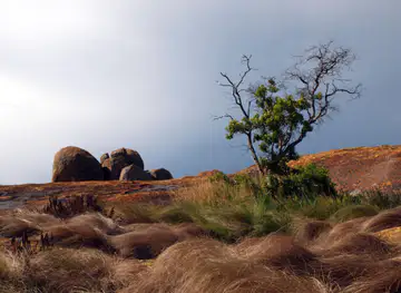
Chimanimani National Park occupies a remote section of eastern Zimbabwe’s Chimanimani Mountains, a rugged highland range forming part of the border landscape with Mozambique. The park is defined by granite ridges, steep valleys, upland grassland, forested slopes and clear mountain streams rather than by roads or large visitor centres. Its terrain rises towards Mount Binga, the highest point in Zimbabwe, and includes extensive areas where walking is the principal way to experience the landscape. Weather can change quickly in the mountains, and the sense of distance is an important part of the park’s character.Read more about Chimanimani National Park
Flora, Wildlife and Conservation
Gateway Towns and Mountain Experience
When is the best time to visit Chimanimani National Park?
Best: May, July–August · 23–26°C| Month | High (°C) | Rainfall (mm) |
|---|---|---|
| January | 28 | 168 |
| February | 28 | 154 |
| March | 29 | 122 |
| April | 29 | 85 |
| May (best) | 26 | 56 |
| June | 22 | 35 |
| July (best) | 23 | 27 |
| August (best) | 26 | 34 |
| September | 30 | 54 |
| October | 33 | 82 |
| November | 34 | 114 |
| December | 31 | 141 |
Getting to and around Chimanimani National Park
How to get there
Transportation
Best attractions in Chimanimani National Park
The principal attraction is the Chimanimani mountain landscape itself, where granite ridges, high grasslands, forested valleys and fast-flowing streams create varied walking country. Mount Binga, Zimbabwe’s highest summit, is a major objective for experienced hikers, although reaching it requires proper preparation rather than a casual excursion. The Nyahodi Wilderness Area represents the park’s more remote character, with broad mountain scenery and limited infrastructure. Along the wider Chimanimani tourism circuit, visitors may also encounter waterfalls and scenic viewpoints near Chimanimani town, while the surrounding Eastern Highlands provide additional forest and rural landscapes outside the national park. Birdwatching and plant observation are rewarding activities in habitats that change with altitude, but this is not primarily a big-game viewing destination. Cultural and archaeological features, including rock-art sites reported in the wider mountain region, should be approached with respect and only through appropriate local or official guidance.
-
Tourist attraction
Tessa's Pool
Experience the beauty and tranquility of Tessa's Pool in Chimanimani, a natural oasis perfect for swimming and outdoor adventures.
-
Tourist attraction
Peterhouse Falls
Experience the breathtaking beauty and tranquility of Peterhouse Falls in Charleswood, a perfect retreat for nature lovers and adventure seekers.
-
Tourist attraction
Digbys Falls
Experience the breathtaking beauty and tranquility of Digbys Falls, a stunning natural attraction in Charleswood, perfect for relaxation and adventure.
-
 Park
Mutekeswane
Explore the breathtaking landscapes and rich biodiversity of Mutekeswane Park in Chimanimani, a natural paradise for adventure seekers and nature lovers.


Best landmarks in Chimanimani National Park
Mount Binga is the defining natural landmark of Chimanimani National Park and the highest summit in Zimbabwe, rising within the rugged border mountains. The surrounding granite ridges and escarpments are equally important, expressing the geological character of the Eastern Highlands through exposed rock, narrow valleys and steep slopes. The Nyahodi Wilderness Area is a significant remote landscape rather than a constructed monument, valued for its isolation, upland scenery and mountain habitats. Streams, waterfalls and forested valleys provide further points of character, although their appearance and accessibility vary with rainfall. The park’s significance also extends beyond geology: its position along the Zimbabwe–Mozambique border, its highland ecology and its association with older cultural landscapes give the mountains a layered identity. Rock-art and archaeological places reported in the wider Chimanimani region should be treated as protected cultural evidence, not as objects for collecting or unauthorised exploration.
-
Tourist attraction
Tessa's Pool
Discover Tessa's Pool, a breathtaking natural attraction in Chimanimani, where crystal-clear waters meet stunning landscapes for an unforgettable experience.
-
Nature preserve
Chimanimani National Reserve
Explore Chimanimani National Reserve, a breathtaking nature preserve in Mozambique, where stunning landscapes and diverse wildlife await adventure seekers.


Explore Chimanimani National Park on the map
Plan your trip on one map. See where the top attractions, landmarks, restaurants and hotels are, and book hotels and experiences in a few clicks.
Best hotels in Chimanimani National Park
Get your free copy of our complete guide to Chimanimani National Park, delivered straight to you.
Everything on this page, from attractions and restaurants to essentials and local phrases, in one PDF you can read offline, print or share.
Already have an account? Sign in
Your Chimanimani National Park guide is ready.
We'll send it to · Not you? Sign out

Getting your guide ready…
We are putting together a fresh copy of the Chimanimani National Park guide. This can take up to a minute.
This can take a few moments. If your browser asks, choose Allow so the download can start. You'll find the guide in your Downloads folder.
Nothing happened? Download it again
Sorry, the guide is taking longer than usual. Please try again in a minute, or get it by email instead.
Chimanimani National Park essentials
Currency and Payment
Safety
Emergency Situations
Do's and Don'ts
Local Tips
From Eve
Local phrases worth knowing
You don't need to get them perfect. A few words go a long way, and locals appreciate the effort.
Basics
| English | Local | Say it |
|---|---|---|
| Hello | Mhoroi | [m-ho-roy] |
| Goodbye | Kwaheri | [kwa-he-ree] |
| Yes | Ndinoye | [n-dee-noh-ye] |
| No | Hapana | [ha-pa-na] |
| Please/You're welcome | Ndatenda | [n-da-ten-da] |
| Thank you | Ndinotenda | [n-dee-no-ten-da] |
| Excuse me/Sorry | Samaita | [sa-ma-i-ta] |
| How are you? | Unjani? | [oon-ja-nee] |
| Fine. And you? | Zvandiri kumusha. Wako? | [zvan-di-ree koo-moo-sha wa-ko] |
| Do you speak English? | Watiwandei kushora chikamu? | [wa-tee-wan-day koo-sho-ra chi-ka-moo] |
| I don't understand | Handigone kuziva | [han-di-go-ne koo-zee-va] |
Eating & Drinking
| English | Local | Say it |
|---|---|---|
| I'd like to see the menu, please | Ndinoda kuona menu, ndapota | [n-dee-no-da koo-o-na me-nu, n-da-po-ta] |
| I don't eat meat | Handichide nyama | [han-di-chee-de nya-ma] |
| Cheers! | Mazvita! | [ma-zvee-ta] |
| I would like to pay, please | Ndinoda kubhadhara, ndapota | [n-dee-no-da koo-ba-dha-ra, n-da-po-ta] |
Emergencies
| English | Local | Say it |
|---|---|---|
| Help! | Kunzunguza! | [koo-nzoo-ngoo-za] |
| Go away! | Famba! | [fam-ba] |
| Call the Police! | Dzvanyirira Police! | [dzva-nyi-ree-ra po-lee-ce] |
| Call a doctor! | Dzvanyirira doki! | [dzva-nyi-ree-ra do-ki] |
| I'm lost | Ndiri kupedza | [n-dee-ree koo-pe-dza] |
| I'm ill | Ndiri kumusha | [n-dee-ree koo-moo-sha] |
Shopping
| English | Local | Say it |
|---|---|---|
| I'd like to buy... | Ndinoda kushandisa... | [n-dee-no-da koo-shan-di-sa] |
| I'm just looking | Ndiripo ndichitaura | [n-dee-ree-po n-dee-chee-tau-ra] |
| How much is it? | Zvinoda mari iyi? | [zvi-no-da ma-ree ee-yi] |
| That's too expensive | Iyi inotsika saka | [ee-yi ee-no-tsee-ka sa-ka] |
| Can you lower the price? | Unogona kushandisa mari? | [oo-no-go-na koo-shan-di-sa ma-ree] |
Time & Numbers
| English | Local | Say it |
|---|---|---|
| What time is it? | Saa ndiani? | [sa-ya n-dee-a-nee] |
| It's one o'clock | Saa yekudzvanya | [sa-ya ye-koo-dzva-nya] |
| Half past (10) | Makore matanhatu | [ma-ko-re ma-tan-ha-too] |
| Morning | Mangwanani | [man-gwa-na-nee] |
| Afternoon | Mugodhi | [moo-go-dee] |
| Evening | Makomborero | [ma-kom-bo-re-ro] |
| Yesterday | Chakatemba | [cha-ka-tem-ba] |
| Today | Nhasi | [n-ha-see] |
| Tomorrow | Mangwana | [man-gwa-na] |
| 1 | Makumi maviri | [ma-koo-me ma-vee-ree] |
| 2 | Makumi matatu | [ma-koo-me ma-ta-too] |
| 3 | Makumi mashanu | [ma-koo-me ma-sha-noo] |
| 4 | Makumi marwadzo | [ma-koo-me ma-rwa-dzo] |
| 5 | Makumi masere | [ma-koo-me ma-se-re] |
| 6 | Makumi masere nekutakura | [ma-koo-me ma-se-re ne-koo-ta-koo-ra] |
| 7 | Makumi manomwe | [ma-koo-me ma-no-mwe] |
| 8 | Makumi manhuru | [ma-koo-me man-hoo-roo] |
| 9 | Makumi marobhe | [ma-koo-me ma-ro-bhe] |
| 10 | Gumi | [goo-mee] |
Transport & Directions
| English | Local | Say it |
|---|---|---|
| Where's a/the...? | Kunonzi veku... | [koo-no-nzee ve-koo] |
| What's the address? | Pano pane address here? | [pa-no pa-ne ad-dress here] |
| Can you show me (on the map)? | Unogona kundipa (pe map)? | [oo-no-go-na kun-dee-pa pe map] |
| When's the next (bus)? | Kupi chikomborero ichi? | [koo-pee chi-kom-bo-re-ro ee-chee] |
| A ticket (to ....) | Ticketi (ku ....) | [tee-ke-ti koo] |
History of Chimanimani National Park
An Ancient Mountain Foundation
The Chimanimani mountains are part of Zimbabwe’s ancient Eastern Highlands, a geological landscape shaped over very long timescales by uplift, erosion and the weathering of hard crystalline rock. Granite ridges, isolated outcrops and deeply cut valleys give the area its characteristic form, while altitude and rainfall create marked changes in vegetation over relatively short distances. This geological foundation explains both the dramatic scenery and the practical difficulty of moving through the park, where steep slopes and broken terrain have limited large-scale development.
Early Communities and Mountain Use
Long before the area became a protected landscape, the Chimanimani mountains formed part of the cultural and economic world of communities living in the Eastern Highlands. People used the valleys, woodland and grassland for movement, cultivation, gathering and grazing, while rock shelters and paintings in the wider Chimanimani region point to much earlier human activity. Interpretations of archaeological and cultural sites require care, particularly where precise dates or community associations are uncertain, but the evidence makes clear that the mountains are a cultural landscape as well as a natural one.
Borderlands and Colonial Administration
The Chimanimani range developed as a borderland between present-day Zimbabwe and Mozambique, with ridges and valleys influencing movement, trade and political administration. During the colonial period, the surrounding Eastern Highlands were increasingly mapped, administered and connected to commercial agriculture and settler tourism, although the high mountain interior remained comparatively remote. The boundary itself did not erase older patterns of movement or local knowledge. Instead, it added a political dimension to a landscape already shaped by communities, altitude and difficult terrain.
Protected Area and Modern Conservation
Chimanimani National Park was established to protect a substantial section of the mountain environment, including its forests, grasslands, streams and high-altitude habitats. Protection has also helped preserve a setting valued for walking, scenery and ecological research rather than intensive safari tourism. Management remains part of a wider regional picture: the Chimanimani mountains continue across the international boundary, and conservation, rural livelihoods, access and tourism must be considered together. Modern visits therefore take place in a landscape where wilderness protection and the practical needs of nearby communities remain closely connected.
Chimanimani National Park in Photos
Browse through our photo collection highlighting the charm and character of the destination.
Neighbouring destination travel guides
The closest destinations to Chimanimani National Park, if you have time for more than one.
-

-

-

-

-


Swipe for more destinations
Explore more

Explore more of Manicaland
Discover Manicaland, Zimbabwe's eastern paradise, where lush mountains, misty forests, and ancient ruins promise an unforgettable adventure.
Explore Manicaland
Explore more of Zimbabwe
Discover Zimbabwe: A land of majestic waterfalls, abundant wildlife, ancient ruins, and vibrant culture. Perfect for adventure seekers and history enthusiasts alike.
Explore Zimbabwe