

Litchfield National Park Travel Guide - Free Web & App
Your ultimate guide to Litchfield National Park. Discover top landmarks, proposed trips, and local tips. Free on the web or via the Evendo companion app.


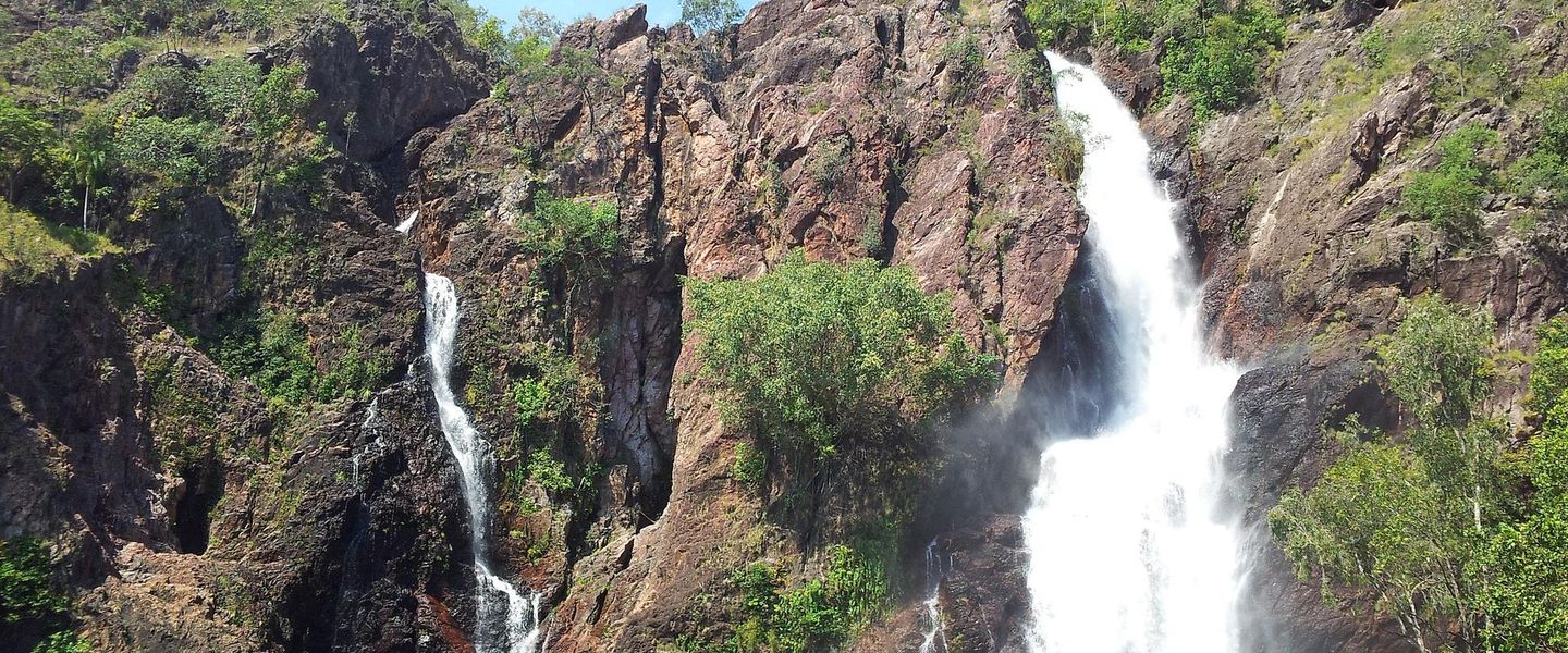


Litchfield National Park, Australia, pairs magnetic termite mounds, monsoon waterfalls and swimming holes with walking trails, wildlife and four-wheel-drive routes.
Water and Stone
Litchfield National Park occupies about 1,500 square kilometres of sandstone country in Australia's Northern Territory, roughly 100 kilometres south-west of Darwin. Its tablelands, wooded savannah and deeply cut escarpments are shaped by the tropical wet-and-dry climate, which transforms the park during the summer rains and sustains waterfalls, streams and monsoon pockets through the drier months. Florence Falls, Wangi Falls, Tolmer Falls and Tjaynera Falls are among its best-known sights, while Buley Rockhole offers a series of natural pools and cascades. Swimming access can vary with seasonal conditions, water quality and park management advice.Read more about Litchfield National Park
Country and Culture
Exploring the Park
When is the best time to visit Litchfield National Park?
Best: June–August · 28–29°C| Month | High (°C) | Rainfall (mm) |
|---|---|---|
| January | 37 | 310 |
| February | 36 | 280 |
| March | 36 | 240 |
| April | 34 | 160 |
| May | 32 | 70 |
| June (best) | 29 | 20 |
| July (best) | 28 | 20 |
| August (best) | 29 | 20 |
| September | 32 | 40 |
| October | 33 | 100 |
| November | 35 | 200 |
| December | 36 | 260 |
Getting to and around Litchfield National Park
How to get there
Transportation
Best attractions in Litchfield National Park
Litchfield's central attractions are its waterfalls, rock pools, escarpments and unusual termite architecture. Florence Falls drops into a forested gorge reached by a signed walk and viewing area, while nearby Buley Rockhole is known for a succession of rocky pools and cascades; whether water entry is permitted depends on current conditions and management advice. Wangi Falls combines a broad seasonal waterfall with walking routes through monsoon vegetation, and Tolmer Falls provides a substantial lookout over a deep gorge. Tjaynera Falls, reached through the Sandy Creek area, offers a more remote walking experience when access is open. The Magnetic Termite Mounds display the tall, narrow structures built by termites in an orientation that helps moderate internal temperatures. Longer routes include the Tabletop Track, while Blyth Homestead and the Lost City add historic and geological interest to the park's quieter northern areas.
-
Wildlife park
Territory Wildlife Park
Immerse yourself in the beauty of Australia’s wildlife at Territory Wildlife Park, a stunning blend of nature, education, and adventure.
-
Tourist attraction
Berry Springs Nature Park
Explore Berry Springs Nature Park: A serene oasis in the Northern Territory filled with lush landscapes, wildlife, and crystal-clear swimming holes.
-
Caravan Park
Litchfield Banyan Tree Resort
Discover the beauty of Litchfield Banyan Tree Resort, where adventure meets relaxation in the heart of Northern Territory.
-
 National park
Litchfield Tourist Park
Discover the breathtaking landscapes and unique wildlife of Litchfield Tourist Park, a must-visit national park in Australia’s Northern Territory.


Best landmarks in Litchfield National Park
Litchfield's defining landmarks are mostly natural. The sandstone tableland and its dissected escarpments create the elevated setting for Florence Falls, Tolmer Falls and Wangi Falls, while Buley Rockhole marks a smaller-scale landscape of sculpted granite and flowing water. The Magnetic Termite Mounds are an important visual and ecological landmark, their blade-like forms standing across open woodland. Blyth Homestead is the principal surviving historic structure within the park, associated with the region's pastoral history, and the Bamboo Creek area preserves reminders of tin mining. The Lost City, a cluster of weathered sandstone formations reached by a route with access conditions that can vary, is noted for its resemblance to a ruined settlement. Together these features connect geology, seasonal water, Aboriginal Country, pastoral expansion and mining history without turning the park into a conventional built heritage destination.
-
Swimming lake
Florence Falls Waterhole
Explore the enchanting Florence Falls Waterhole, a natural oasis in Litchfield National Park perfect for swimming, hiking, and wildlife watching.
-
Nature preserve
Buley Rockhole (car park)
Experience the tranquil beauty of Buley Rockhole, where crystal-clear waters and stunning landscapes await in Litchfield National Park.
-
Tourist attraction
Magnetic Termite Mounds
Explore the spectacular Magnetic Termite Mounds in Litchfield National Park, a stunning natural wonder showcasing termite engineering and the beauty of the Northern Territory.
-
Scenic spot
Wangi Falls
Discover the breathtaking beauty of Wangi Falls, a hidden gem in Litchfield National Park, perfect for swimming, hiking, and enjoying nature's tranquility.


Explore Litchfield National Park on the map
Plan your trip on one map. See where the top attractions, landmarks, restaurants and hotels are, and book hotels and experiences in a few clicks.
Best hotels in Litchfield National Park
Best restaurants in Litchfield National Park
Litchfield National Park has no broad restaurant scene within its protected landscape, so visitors generally eat at accommodation, picnic or camping facilities where provided, or carry food for the day. Batchelor is the principal nearby place to look for cafés, takeaway food, pub meals and basic supplies, while Darwin offers the widest range of Northern Territory dining. The region's food culture reflects tropical produce, cattle-country traditions and Australian outdoor travel rather than a single dish associated exclusively with the park. Pack meals for remote waterfall circuits and do not assume that a kiosk or food outlet will be operating at every attraction. Farm and regional produce may appear in businesses around the gateway settlements, but availability varies seasonally and visitors should check locally rather than relying on services inside the park.
-
Caravan Park
Litchfield Banyan Tree Resort
Experience nature's beauty at Litchfield Banyan Tree Resort – your gateway to adventure near Litchfield National Park.
-
Camping Ground
Litchfield Tourist Park
Experience nature's beauty at Litchfield Tourist Park - your gateway to adventure in Australia's stunning Northern Territory.
-
Science museum
Zebra Stone
Explore Zebra Stone: A unique science museum showcasing stunning geological wonders amidst nature's beauty.
-
Resort hotel
Litchfield Outback Resort
Experience adventure and relaxation at Litchfield Outback Resort, your gateway to the stunning landscapes of Northern Territory's Litchfield National Park.


Best bars in Litchfield National Park
Evenings in Litchfield National Park are quiet and oriented towards camping, self-contained accommodation and the sounds of the tropical bush rather than organised nightlife. Batchelor, outside the park, is the nearest settlement for a traditional pub atmosphere and an evening meal, although its choice is limited compared with Darwin. Visitors staying in the park or at rural accommodation should expect to bring provisions, observe any fire and quiet-hour rules, and plan around darkness and wildlife rather than seek bars or clubs. Darwin is the appropriate base for a larger selection of licensed venues, live entertainment and late-night options, but it is a separate urban destination requiring a substantial road journey from the park.
-
Pub
Berry Springs Tavern
Discover Berry Springs Tavern, a vibrant pub offering delicious local cuisine and refreshing drinks in the stunning Northern Territory.
-
Bar
Humpty Doo Hotel
Discover local flavors and vibrant atmosphere at Humpty Doo Hotel, the heart of Northern Territory's dining and entertainment scene.
-
Pub
Noonamah Tavern
Discover Noonamah Tavern, the heart of Northern Territory's pub culture, offering delectable steaks, local brews, and an inviting atmosphere.
-
Pub
Darwin River Tavern
Experience the charm of the Northern Territory at Darwin River Tavern, a cozy pub with great food, drinks, and stunning natural views.


Best nightclubs in Litchfield National Park
Evenings in Litchfield National Park are quiet and oriented towards camping, self-contained accommodation and the sounds of the tropical bush rather than organised nightlife. Batchelor, outside the park, is the nearest settlement for a traditional pub atmosphere and an evening meal, although its choice is limited compared with Darwin. Visitors staying in the park or at rural accommodation should expect to bring provisions, observe any fire and quiet-hour rules, and plan around darkness and wildlife rather than seek bars or clubs. Darwin is the appropriate base for a larger selection of licensed venues, live entertainment and late-night options, but it is a separate urban destination requiring a substantial road journey from the park.
-
National park
Litchfield National Park
Experience the breathtaking beauty and adventure of Litchfield National Park, a natural wonder in Australia's Northern Territory.
-
Swimming lake
Florence Falls Waterhole
Experience the beauty of Florence Falls Waterhole, a tranquil swimming lake surrounded by lush landscapes in Litchfield National Park.
-
Caravan Park
Litchfield Banyan Tree Resort
Discover the beauty and adventure at Litchfield Banyan Tree Resort, where nature meets relaxation in the heart of Northern Territory.
-
Camping Ground
Litchfield Tourist Park
Discover the beauty of Litchfield National Park at Litchfield Tourist Park, where adventure meets comfort in the heart of Australia's wilderness.


Best shops in Litchfield National Park
Shopping inside Litchfield National Park is limited, with no town centre or extensive retail area, so visitors should obtain fuel, food, medicines and outdoor supplies before entering or use businesses in Batchelor and Darwin. Batchelor provides the nearest gateway services, while Darwin has the broader selection of supermarkets, outdoor retailers, galleries, Aboriginal art outlets and regional products. Appropriate souvenirs may include locally made art, books about Northern Territory landscapes, food products or practical outdoor goods, provided they are purchased through legitimate businesses and can be carried responsibly. Do not collect rocks, plants, feathers, shells or cultural materials from the park. Small rural businesses may have irregular opening patterns, so remote itineraries are best planned with supplies already secured.
-
National park
Litchfield National Park
Explore Litchfield National Park: a stunning Australian escape with waterfalls, wildlife, and breathtaking landscapes in the heart of the Northern Territory.
-
Swimming lake
Florence Falls Waterhole
Experience the stunning Florence Falls Waterhole, a natural oasis in Litchfield National Park, perfect for swimming, hiking, and enjoying nature's beauty.
-
Nature preserve
Buley Rockhole (car park)
Experience the enchanting beauty of Buley Rockhole, a natural oasis in Litchfield Park, perfect for swimming and relaxation amid stunning scenery.
-
Scenic spot
Wangi Falls
Discover the breathtaking beauty of Wangi Falls in Litchfield National Park—a natural oasis perfect for relaxation and exploration.


Get your free copy of our complete guide to Litchfield National Park, delivered straight to you.
Everything on this page, from attractions and restaurants to essentials and local phrases, in one PDF you can read offline, print or share.
Already have an account? Sign in
Your Litchfield National Park guide is ready.
We'll send it to · Not you? Sign out

Getting your guide ready…
We are putting together a fresh copy of the Litchfield National Park guide. This can take up to a minute.
This can take a few moments. If your browser asks, choose Allow so the download can start. You'll find the guide in your Downloads folder.
Nothing happened? Download it again
Sorry, the guide is taking longer than usual. Please try again in a minute, or get it by email instead.
Litchfield National Park essentials
Currency and Payment
Safety
Emergency Situations
Do's and Don'ts
Local Tips
From Eve
Local phrases worth knowing
You don't need to get them perfect. A few words go a long way, and locals appreciate the effort.
Basics
| English | Local | Say it |
|---|---|---|
| Hello | G'day | [G'day] |
| Goodbye | See ya mate | [See ya mate] |
| Yes | Yeah | [Yeah] |
| No | Nah | [Nah] |
| Please/You're welcome | Please/No worries | [Please/No worries] |
| Thank you | Cheers mate | [Cheers mate] |
| Excuse me/Sorry | Sorry mate | [Sorry mate] |
| How are you? | How ya goin'? | [How ya goin'?] |
| Fine. And you? | Not bad. You? | [Not bad. You?] |
| Do you speak English? | You speak English? | [You speak English?] |
| I don't understand | No idea mate | [No idea mate] |
Eating & Drinking
| English | Local | Say it |
|---|---|---|
| I'd like to see the menu, please | Menu please | [Menu please] |
| I don't eat meat | No meat for me | [No meat for me] |
| Cheers! | Cheers mate! | [Cheers mate!] |
| I would like to pay, please | Bill please | [Bill please] |
Emergencies
| English | Local | Say it |
|---|---|---|
| Help! | Help! | [Help!] |
| Go away! | Bugger off! | [Bugger off!] |
| Call the Police! | Police! | [Police!] |
| Call a doctor! | Doctor! | [Doctor!] |
| I'm lost | Lost mate | [Lost mate] |
| I'm ill | Sick mate | [Sick mate] |
Shopping
| English | Local | Say it |
|---|---|---|
| I'd like to buy... | I wanna buy... | [I wanna buy...] |
| I'm just looking | Just browsing | [Just browsing] |
| How much is it? | How much? | [How much?] |
| That's too expensive | Too pricey | [Too pricey] |
| Can you lower the price? | Can you do a deal? | [Can you do a deal?] |
Time & Numbers
| English | Local | Say it |
|---|---|---|
| What time is it? | What's the time? | [What's the time?] |
| It's one o'clock | It's one | [It's one] |
| Half past (10) | Half past ten | [Half past ten] |
| Morning | Mornin' | [Mornin'] |
| Afternoon | Arvo | [Arvo] |
| Evening | Evenin' | [Evenin'] |
| Yesterday | Yesty | [Yesty] |
| Today | Today | [Today] |
| Tomorrow | Tomorra | [Tomorra] |
| 1 | One | [One] |
| 2 | Two | [Two] |
| 3 | Three | [Three] |
| 4 | Four | [Four] |
| 5 | Five | [Five] |
| 6 | Six | [Six] |
| 7 | Seven | [Seven] |
| 8 | Eight | [Eight] |
| 9 | Nine | [Nine] |
| 10 | Ten | [Ten] |
Transport & Directions
| English | Local | Say it |
|---|---|---|
| Where's a/the...? | Where's the...? | [Where's the...?] |
| What's the address? | Address? | [Address?] |
| Can you show me (on the map)? | Show me on the map? | [Show me on the map?] |
| When's the next (bus)? | Next bus? | [Next bus?] |
| A ticket (to ....) | Ticket to... | [Ticket to...] |
History of Litchfield National Park
Ancient Sandstone Country
Litchfield's escarpments, plateaux and rocky falls belong to the ancient sandstone landscapes of the Northern Territory. Over immense geological timescales, erosion cut through the resistant tableland and created the cliffs, gullies and seasonal drainage lines that now define the park. The contrast between exposed woodland and sheltered, humid pockets is especially marked around the waterfalls, where permanent or semi-permanent springs can support vegetation unlike that on the surrounding uplands. This geological foundation explains why water, rather than monumental architecture, is central to Litchfield's identity.
Traditional Country and Continuing Culture
Litchfield National Park lies on the traditional Country of the Kungarakan and Marranunggu peoples. Aboriginal occupation of the region extends across many generations, with knowledge of seasonal water, plants, animals and travel routes embedded in relationships between people and Country. Visitors should understand the park as a living cultural landscape rather than an empty wilderness created by modern conservation. Some places may have cultural sensitivities or access arrangements, and respectful behaviour includes following signs, staying on designated routes and not disturbing artefacts, sites or natural features.
European Exploration and Naming
The park takes its name from Frederick Henry Litchfield, who travelled through the Northern Territory as part of an 1865 government expedition. European mapping and exploration brought new names to a landscape already known through Aboriginal geographic knowledge. Later movement through the region was connected with pastoral expansion, transport routes and the search for mineral resources. The surviving name therefore reflects one layer of the area's history, while the deeper story of Country belongs to the Aboriginal peoples whose connections with the landscape continue.
Pastoralism and Tin Mining
Before protected-area tourism became the dominant reason for visiting, parts of the Litchfield region were used for pastoralism and mining. Tin extraction at Bamboo Creek left industrial traces in the park, while Blyth Homestead records the practical realities of remote cattle-settlement life. The homestead, built in the early twentieth century, was associated with the Blyth River pastoral operation and illustrates the difficulty of maintaining a working station in a tropical environment. These remains provide a human counterpoint to the park's waterfalls, woodlands and escarpments.
Protection and Recreation
Litchfield National Park was declared in 1986, bringing the principal landscape under formal conservation management while allowing carefully managed recreation. Roads, walking routes, picnic areas and selected swimming places have made the park one of the Northern Territory's most accessible natural destinations from Darwin. Management now balances visitor access with protection of watercourses, monsoon vegetation, wildlife, cultural values and the wider ecological character of the tablelands. Seasonal weather remains a determining force, and wet-season flooding can reshape access and visitor patterns.
Litchfield National Park in Photos
Browse through our photo collection highlighting the charm and character of the destination.
Neighbouring destination travel guides
The closest destinations to Litchfield National Park, if you have time for more than one.
-

-

-

-

-


Swipe for more destinations
Explore more

Explore more of Top End
Discover the untamed beauty and rich culture of Australia's Top End, from Darwin's lively markets to the ancient landscapes of Kakadu and Litchfield National Parks.
Explore Top End
Explore more of Australia
Discover the diverse landscapes, vibrant cities, and unique wildlife of Australia, a captivating destination offering endless adventures and unforgettable experiences.
Explore Australia