Background

Bunkers on Fanø (Atlantic Wall Remains)

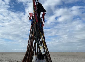
Concrete relics of the Atlantic Wall scattered across Fanø’s dunes and beaches, where stark wartime bunkers meet wide North Sea horizons.

4.6

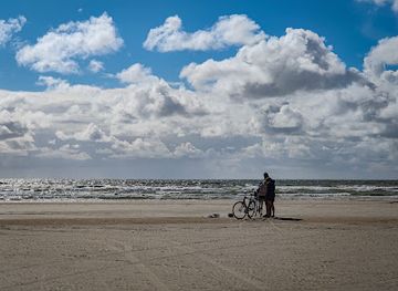
Scattered along the dunes and beaches of Fanø, the World War II bunkers form one of Denmark’s most striking reminders of the Atlantic Wall. Around 300 concrete fortifications once guarded the entrance to Esbjerg, forming part of a vast coastal defence system. Today, many lie half-buried in sand or tilted on the shoreline, creating an atmospheric mix of military history, stark architecture and wide North Sea landscapes that invites exploration, contemplation and photography.

A brief summary to Bunkers on Fanø

  • Fanø, 6720, DK
  • Duration: 1.5 to 4 hours
  • Free
  • Environment icon Outdoor
  • Mobile reception: 4 out of 5

Local tips

  • Bring a strong flashlight and sturdy footwear if you plan to enter any open bunkers; interiors are dark, uneven and can be damp or sandy.
  • Check local tide and weather conditions before walking long stretches of beach between bunker sites, especially in windy or stormy periods.
  • Dress in windproof layers; even on sunny days the exposed beaches and dunes around the bunkers can feel significantly cooler.
  • Respect fenced-off dunes and signed nature protection areas surrounding some bunkers to help protect fragile Wadden Sea ecosystems.
  • If you want deeper context, look for locally advertised guided tours about Fanø’s role in the Atlantic Wall, often offered in peak season.
widget icon

Getting There

  • Ferry and Walking

    From Esbjerg, take the passenger and car ferry to Nordby on Fanø, a crossing of about 12 minutes with frequent daily departures. A standard adult foot passenger ticket typically costs around 60–90 DKK return, with extra fees for vehicles. From Nordby, many of the northern bunker sites can be reached on foot in 20–30 minutes along signposted paths and gravel tracks. The walk is flat but can be sandy in places and may be challenging for wheelchairs or strollers.

  • Ferry and Bicycle

    Cycling is a convenient way to reach several bunker clusters scattered along Fanø’s west coast. Bring your own bike or rent one in Nordby; expect daily rental prices from roughly 100–200 DKK depending on type. From Nordby to the northern bunker areas is about 20–30 minutes of cycling on mostly flat roads and tracks. Strong coastal winds are common, so allow extra time and wear windproof clothing.

  • Ferry and Car

    If you bring a car on the Esbjerg–Fanø ferry, budget from around 200–350 DKK each way for a standard vehicle including driver, depending on season and time of day. Driving from Nordby to access points near the bunkers usually takes 10–15 minutes on paved and gravel roads, with basic parking near popular approach points. In high season, some parking areas can fill up quickly and gravel sections may be uneven after heavy rain.

Bunkers on Fanø location weather suitability

  • Weather icon Clear Skies
  • Weather icon Windy Conditions
  • Weather icon Mild Temperatures
  • Weather icon Cold Weather
  • Weather icon Hot Weather

Unlock the Best of Bunkers on Fanø

Buy tickets

    No tickets available

Book tours with entry

    No tours available

Book tours without entry

    No tours available

q

Discover more about Bunkers on Fanø

Concrete Sentinels of the Atlantic Wall

Fanø’s bunkers are the most visible traces of the island’s role in the Second World War, when it formed part of the German Atlantic Wall guarding the North Sea coast. Spread mainly across the northern and central parts of the island, these reinforced concrete structures were built to control the sea routes into Esbjerg, a strategically vital harbour for any potential Allied landing. In total, around three hundred bunkers and related fortifications were constructed here, from gun batteries and radar posts to command shelters and personnel quarters. Many are now softened by time, sand and weather, yet their angular silhouettes still rise from the dunes as stark reminders of Europe’s wartime landscape.

Strategic Island at the Gate to Esbjerg

Fanø’s location at the mouth of the Esbjerg channel made it a natural focal point for coastal artillery. Batteries such as Fanø Nord and positions near Grådyb were aligned to cover shipping lanes and to coordinate with heavy guns on the mainland. Observation bunkers monitored movements at sea and in the air, while underground command posts linked multiple batteries into a single defensive network. Although Denmark saw relatively little direct fighting compared with other fronts, the island bristled with minefields, trenches, concrete roads and gun emplacements. Today, the mines are gone and most trenches have been reclaimed by vegetation, but the bunkers remain as a physical map of how thoroughly this small island was woven into continental warfare.

Dunes, Beaches and Buried Fortifications

What makes the Fanø bunkers so compelling is their setting. On the west side of the island, long, wind-swept beaches and rolling dunes frame grey concrete shells, some half buried by drifting sand, others lying at angles where coastal erosion has undercut their foundations. In several places between Rindby Strand and Sønderho, the bunkers stand fully exposed on the open beach, their interiors accessible at low risk in daylight and calm conditions. Further north, bunker formations near the island’s tip offer wide views across the Wadden Sea, Esbjerg harbour and Nordby. Here, the contrast between rough wartime construction and the gentle, protected nature of the Wadden Sea landscape is especially striking, inviting both photography and quiet reflection on how landscapes change faster than concrete can crumble.

Exploring Inside the Wartime Structures

Some bunkers on Fanø remain open, allowing you to step into the cool, echoing rooms where soldiers once worked the radios, plotted trajectories and waited through long shifts. Narrow corridors connect small chambers, ventilation shafts pierce thick walls, and rusted fittings hint at the equipment that once filled the interior. A flashlight is essential, as there is no installed lighting and sudden level changes or low doorways are common. On the surface, you can identify different bunker types by their shapes: low flanking bunkers with firing slits parallel to the beach, larger command posts with observation platforms, and circular foundations where gun turrets once sat. Informal paths meander through the dunes between them, and at a few sites local associations occasionally arrange guided tours that delve deeper into the history and engineering details.

From War Relics to Open-Air History Lesson

In the decades since the war, Fanø’s bunkers have gradually shifted from military infrastructure to historical landmarks. Some have been partially covered for safety or to protect the surrounding dunes, while others have become canvases for graffiti or focal points for photo walks along the shoreline. Their rough, uncompromising forms now provide a backdrop for kite flying, beach walks and birdwatching rather than gun crews and radar operators. For visitors, the bunkers offer a rare chance to see a dense concentration of Atlantic Wall remains in a relatively compact, accessible area. Combined with Fanø’s beaches, heathland and forest plantations, they turn a simple coastal walk into an open-air lesson in twentieth‑century history, where every block of concrete carries a story of fear, engineering and changing European borders.

Busiest months of the year

Busiest hours of the day

Popular Experiences near Bunkers on Fanø

Popular Hotels near Bunkers on Fanø

Select Currency