Background

Panorama Walking Route, Mariager Fjord

A 10 km premium hillside-and-fjord loop near Hobro, weaving through meadows, juniper slopes and shoreline for some of Denmark’s most evocative panoramic views.

4.8

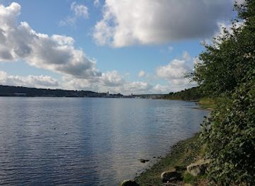
The Panorama Walking Route near Hobro is a 10 km premium hiking trail tracing the slopes and shoreline of Mariager Fjord, often described as one of Denmark’s most beautiful walks. Beginning by the marina and climbing into the Bramslev Hills, it weaves through meadows, juniper scrub and light woodland, with frequent benches and spectacular viewpoints across the fjord. Well-marked, varied underfoot yet manageable for most walkers, it offers a classic Danish landscape experience in just three hours.

A brief summary to Panorama Walking Route

  • Nedre Strandvej 71, Hobro, 9500, DK
  • Duration: 2.5 to 4 hours
  • Free
  • Environment icon Outdoor
  • Mobile reception: 4 out of 5
  • Monday 12 am-12 am
  • Tuesday 12 am-12 am
  • Wednesday 12 am-12 am
  • Thursday 12 am-12 am
  • Friday 12 am-12 am
  • Saturday 12 am-12 am
  • Sunday 12 am-12 am

Local tips

  • Wear sturdy footwear: much of the 10 km route follows narrow natural paths and grassy slopes that can be slippery after rain.
  • Allow at least three hours for the full loop and extra time if you plan a meal or coffee stop near Bramslev Hills.
  • Respect grazing animals by keeping distance, closing gates behind you and avoiding sudden movements around cattle and sheep.
  • Pack layers and a windproof jacket; even on sunny days the exposed sections above Mariager Fjord can feel breezy.
  • Bring water and light snacks, as there are no shops directly on the path; you will only find refreshments at the marina or near Bramslev.
widget icon

Getting There

  • Regional train and walking

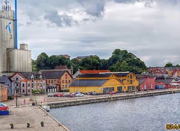
    From Aalborg, take a regional train to Hobro Station, with journeys typically taking 45–55 minutes and standard one-way fares usually around 70–110 DKK in standard class. From the station, walk roughly 30–40 minutes on pavements and local paths to reach the marina area at Nedre Strandvej, where access to the Panorama Walking Route is signposted. The approach is mostly level and suitable for anyone comfortable with a longer urban walk.

  • Car from Aarhus and local parking

    Driving from central Aarhus to Hobro generally takes 50–70 minutes via the main motorway network. Expect fuel costs in the range of 70–130 DKK one way depending on vehicle efficiency and current prices. In Hobro, use the larger public car park near the harbour area rather than parking directly on Nedre Strandvej or at the marina, where space is limited and access for residents and emergency vehicles must be kept clear. From the car park, it is a short, well-marked walk to pick up the route.

  • Local bus to Hobro harbour area

    Several regional and local buses serve Hobro from nearby towns such as Mariager and Aars, with typical journey times of 25–50 minutes and single tickets usually between 30–60 DKK depending on zones. From central Hobro, it is an easy 15–25 minute walk on sidewalks and minor roads to the marina and waterfront, where signs and information boards explain the Panorama Walking Route. Services may be less frequent on evenings and weekends, so check schedules in advance.

Panorama Walking Route location weather suitability

  • Weather icon Clear Skies
  • Weather icon Mild Temperatures
  • Weather icon Any Weather
  • Weather icon Windy Conditions
  • Weather icon Cold Weather
  • Weather icon Hot Weather

Unlock the Best of Panorama Walking Route

Buy tickets

    No tickets available

Book tours with entry

    No tours available

Book tours without entry

    No tours available

Discover more about Panorama Walking Route

Fjordside Trail Between Hobro and Bramslev Hills

The Panorama Walking Route follows a 10 km loop between Hobro and the Bramslev Hills, hugging the northern side of Mariager Fjord. Starting by the yacht harbour, the trail climbs away from the water before undulating along the hillside and later dropping back to the shoreline. It is a compact introduction to the landscapes of North Jutland, combining open views, sheltered valleys and direct contact with the fjord in a single, half‑day walk. Certified as a premium hiking route by a German walking institute, the trail is carefully laid out and signposted. Poles and white markings keep you on track, while information boards at key parking areas outline the route and nearby nature. The marked surface alternates between narrow paths, grass tracks, gravel sections and short stretches of asphalt, offering variety without becoming technical.

Shifting Landscapes Above Mariager Fjord

One of the route’s hallmarks is the constant change in scenery. You wander across beach meadows close to the water, climb through open grasslands and pass through creek valleys that cut down to the fjord. Higher up, juniper thickets and small pockets of forest create intimate green corridors before the trail breaks out once more onto wide views. From several high points the fjord spreads below like a long, glinting lake framed by rounded hills and scattered farms. On calm days the water mirrors the sky; in windier weather whitecaps and moving cloud shadows animate the scene. Benches are placed at many of the best viewpoints, inviting slow pauses rather than a hurried march.

Walking Experience and Trail Practicalities

The full loop typically takes around three hours at a moderate pace, making it an ideal half‑day outing. The route includes an initial staircase section and a series of shorter climbs and descents, so a basic level of fitness helps, but it remains accessible for most walkers accustomed to uneven ground. Good footwear is recommended, especially after rain when grass and earth paths can be slick. Livestock are part of the trail’s character. Sections cross grazed fields where cattle and sheep help maintain open habitat. Gates and stiles structure the crossings, and walkers are expected to give animals space and keep to the marked corridor. This gentle agricultural backdrop, with distant tractors and the sound of bells or lowing cattle, underlines the route’s blend of nature and working landscape.

Views, Wildlife and Seasonal Atmosphere

The Panorama Walking Route rewards attention to small details as much as to sweeping vistas. In spring and summer, wildflowers dot the meadows, butterflies move between bloom patches and birdsong filters from the woods. Along the waterline, wading birds and ducks feed in the shallows, while occasional small boats pass on the fjord below. Season shapes the experience. On bright days, long views up and down Mariager Fjord feel almost coastal; in autumn, foliage colours the slopes and low sun intensifies the light on the water. Even in cooler months the route offers bracing air, stark silhouettes of trees and relatively quiet paths, provided you dress for wind and changeable conditions common near the fjord.

Rest Points, Fjordside Dining and Extensions

Roughly halfway along, near Bramslev, the trail passes close to local restaurants and a hotel, making it easy to combine the hike with a sit‑down meal or coffee break. One restaurant features a panorama terrace overlooking the fjord, echoing the route’s name and giving you time to linger over the very views you have been walking towards. On the return leg, much of the walking traces the shoreline, bringing you down to the water’s edge. Here the mood shifts from lookout drama to a more intimate fjord experience, with reeds, small beaches and the soft slap of waves. Confident walkers sometimes choose to link shorter colour‑coded loops in the Bramslev Hills or nearby areas on another day, but the 10 km Panorama circuit remains the signature experience.

Busiest months of the year

Busiest hours of the day

Popular Experiences near Panorama Walking Route

Popular Hotels near Panorama Walking Route

Select Currency