

Free Keetmanshoop Travel Guide & Mobile App
Plan your Keetmanshoop trip with Evendo. Get free guides to top attractions, restaurants, hotels, and bars. Web access or download the mobile app.


Keetmanshoop, Namibia, pairs desert landscapes, the Quiver Tree Forest, Nama heritage and railway history with a practical gateway to the south.
A Gateway to Southern Namibia
Keetmanshoop lies in Namibia’s arid south, where wide gravel plains, rugged hills and thorn scrub meet the practical rhythms of a railway and road town. The settlement stands on the B1, the principal north–south route through the country, and serves as an important stopping point for travellers heading towards Lüderitz, the Fish River Canyon and the southern border. Its dry climate and open surroundings create a landscape of intense light, sparse vegetation and long horizons.Read more about Keetmanshoop
Quiver Trees and Ancient Stone
A Small Town with Historical Layers
When is the best time to visit Keetmanshoop?
Best: May–June, August · 22–26°C| Month | High (°C) | Rainfall (mm) |
|---|---|---|
| January | 34 | 0 |
| February | 34 | 0 |
| March | 34 | 0 |
| April | 30 | 0 |
| May (best) | 26 | 0 |
| June (best) | 22 | 0 |
| July | 22 | 0 |
| August (best) | 24 | 0 |
| September | 29 | 0 |
| October | 32 | 0 |
| November | 34 | 0 |
| December | 34 | 0 |
Getting to and around Keetmanshoop
How to get there
Transportation
Best attractions in Keetmanshoop
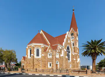
Keetmanshoop’s principal attractions lie in and around the town rather than within a dense historic centre. The Keetmanshoop Museum, housed in the former Rhenish Mission Church, introduces the settlement’s missionary and regional history. Outside town, the Quiver Tree Forest is the defining sight: aloe trees rise from a stony plain, their branching forms adapted to the severe southern climate and embedded in local San cultural history. Close by, the Giant’s Playground presents a maze of enormous dolerite blocks, where weathering has created narrow passages and dramatic piles of stone. The surrounding landscape itself is part of the experience, with dry hills, open plains and unusually clear skies shaping every journey. Keetmanshoop also works as a base for longer southern excursions, including routes towards the Fish River Canyon and Lüderitz, although these are regional journeys rather than city attractions.
-
Tourist attraction
Giant's Playground
Discover the surreal rock formations of Giant's Playground in Namibia, a breathtaking natural attraction perfect for adventure and photography enthusiasts.
39 min drive · 19 km from city centre
-
Tourist attraction
Keetmanshoop Museum
Explore the Keetmanshoop Museum – a cultural gem in Namibia showcasing the rich history and heritage of the region through fascinating exhibits.
2 min walk · 0.2 km from city centre
-
Tourist attraction
Adlerdenkmal
Explore Adlerdenkmal in Keetmanshoop, a significant historical landmark that encapsulates Namibia's rich cultural heritage and offers stunning views.
2 min walk · 0.1 km from city centre
-
Tourist attraction
Quiver Tree Forest
Explore the surreal beauty of Quiver Tree Forest, a natural wonder in Namibia, home to unique quiver trees and stunning landscapes.
35 min drive · 15 km from city centre


Best landmarks in Keetmanshoop
The Keetmanshoop Museum is the town’s most important historic building, occupying the former Rhenish Mission Church and preserving a visible connection with the settlement founded in the nineteenth century. The church’s presence reflects the role of missionary institutions in the early development of the town, while nearby streets and civic buildings reveal Keetmanshoop’s later function as a colonial and regional administrative centre. The railway station represents another defining layer: rail transport helped connect the southern interior with the coast and neighbouring settlements, turning the town into an important service point. Beyond the built environment, the Quiver Tree Forest has become a cultural and natural symbol of Keetmanshoop, while the Giant’s Playground is a geological landmark formed from vast dolerite boulders. Together these sites connect religious history, transport infrastructure and the ancient physical foundations of the Karas landscape.
-
 Hotel
Central Lodge
Central Lodge in Keetmanshoop combines comfort and local charm, perfect for travelers seeking an authentic Namibian experience.
2 min walk · 0.2 km from city centre
-
Restaurant
Wimpy
Discover Wimpy in Keetmanshoop: Your go-to fast-food destination for comfort meals along the scenic B1 National Road.
15 min drive · 5.0 km from city centre
-
Restaurant
KFC Keetmanshoop
Experience the comforting taste of Kentucky Fried Chicken at KFC Keetmanshoop, where delicious flavors meet local charm.
2 min walk · 0.1 km from city centre
-
Restaurant
Schützenhaus Guesthouse
Experience the flavors of Namibia at Schützenhaus Guesthouse, a charming restaurant in Keetmanshoop offering local cuisine and warm hospitality.
6 min walk · 0.5 km from city centre


Explore Keetmanshoop on the map
Plan your Keetmanshoop trip on one map. See where the top attractions, landmarks, restaurants, bars and hotels are, find what's near where you're staying, and book hotels and experiences in a few clicks.
Best hotels in Keetmanshoop
Best restaurants in Keetmanshoop
Keetmanshoop’s dining scene reflects its role as a small regional centre and a stopping point on long southern journeys. Restaurants, cafés and hotel dining rooms generally provide practical meals suited to travellers and local residents, with Namibian and South African influences visible alongside familiar international dishes. Meat, especially beef and game where available, is prominent in the wider southern Namibian food culture, while biltong, grilled fare, bread and simple café meals are common regional reference points. Shops and local food outlets are useful for stocking water, snacks and provisions before heading towards remote attractions. Dining is more dispersed and less specialised than in Windhoek or Swakopmund, so evening choices may be modest. The most locally distinctive food experiences are often connected to Namibian ingredients, farming traditions and the informal character of a desert service town rather than to a concentrated restaurant quarter.
-
Restaurant
Central Lodge
Experience the perfect blend of culinary excellence and comfort at Central Lodge in Keetmanshoop – where every meal tells a story.
2 min walk · 0.2 km from city centre
-
Restaurant
Wimpy
Experience delicious fast food at Wimpy in Keetmanshoop - perfect for travelers seeking quick meals on their journey through Namibia.
15 min drive · 5.0 km from city centre
-
Restaurant
KFC Keetmanshoop
Discover delicious fast food at KFC Keetmanshoop - where crispy chicken meets Namibian hospitality.
2 min walk · 0.1 km from city centre
-
Restaurant
Schützenhaus Guesthouse
Savor the flavors of Namibia at Schützenhaus Guesthouse – a culinary gem in Keetmanshoop offering authentic local dishes.
6 min walk · 0.5 km from city centre


Best bars in Keetmanshoop
Keetmanshoop has a restrained evening scene shaped by its size, regional role and the habits of residents and overnight travellers. Hotel bars, licensed restaurants and local gathering places provide the main opportunities for a drink or a relaxed evening, while nightlife is more likely to centre on conversation and community socialising than on a dedicated club circuit. Visitors should not expect the concentration of cocktail bars, live-music venues or nightclubs found in Windhoek. After dark, the clear southern sky and quiet surroundings can be more distinctive than organised entertainment, although remote outdoor viewing requires sensible planning and respect for private or protected land. Because many travellers use Keetmanshoop as a road stop, evening activity may be early and practical, with establishments and transport arrangements best confirmed locally.
-
Restaurant
Central Lodge
Discover the flavors of Namibia at Central Lodge, a cozy restaurant and hotel in Keetmanshoop offering delightful dishes and warm hospitality.
2 min walk · 0.2 km from city centre
-
Restaurant
Wimpy
Discover Wimpy in Keetmanshoop, where fast food meets comfort, perfect for travelers seeking delicious meals on their journey.
15 min drive · 5.0 km from city centre
-
Restaurant
Schützenhaus Guesthouse
Discover the rich flavors of Namibia at Schützenhaus Guesthouse, a cozy restaurant in Keetmanshoop offering authentic cuisine and warm hospitality.
6 min walk · 0.5 km from city centre
-
Guest house
Quiver Inn Guesthouse
Experience the charm of Keetmanshoop at Quiver Inn Guesthouse, where comfort meets local culture in the heart of Namibia.
5 min walk · 0.4 km from city centre

Best nightclubs in Keetmanshoop
Keetmanshoop has a restrained evening scene shaped by its size, regional role and the habits of residents and overnight travellers. Hotel bars, licensed restaurants and local gathering places provide the main opportunities for a drink or a relaxed evening, while nightlife is more likely to centre on conversation and community socialising than on a dedicated club circuit. Visitors should not expect the concentration of cocktail bars, live-music venues or nightclubs found in Windhoek. After dark, the clear southern sky and quiet surroundings can be more distinctive than organised entertainment, although remote outdoor viewing requires sensible planning and respect for private or protected land. Because many travellers use Keetmanshoop as a road stop, evening activity may be early and practical, with establishments and transport arrangements best confirmed locally.
-
Lounge
Homeground Lounge
Experience the vibrant atmosphere and local flavors at Homeground Lounge, the perfect spot to unwind in Keetmanshoop.
2 min walk · 0.2 km from city centre
-
Bar
Oniikoombo SportS Bar & Social Club
Discover the vibrant Oniikoombo SportS Bar & Social Club in Keetmanshoop, a perfect blend of sports, socializing, and refreshing beverages.
6 min drive · 2.2 km from city centre


Best shops in Keetmanshoop
Shopping in Keetmanshoop is primarily practical, with central shops, supermarkets, fuel stations and small independent businesses serving residents and travellers crossing southern Namibia. There is no large specialist shopping district, but the town is useful for replenishing food, water, vehicle supplies and basic travel equipment before heading into remote areas. Visitors may find Namibian crafts, curios, leather goods, beadwork and locally produced souvenirs through accommodation businesses, craft sellers or regional outlets, although stocks and opening arrangements vary. Products associated with the wider south can include handmade items and food provisions reflecting livestock farming and desert life. The town’s retail character is modest and functional rather than heavily tourist-oriented, which makes advance planning important for travellers seeking specific equipment or specialised gifts.
-
Supermarket
Shoprite Keetmanshoop
Discover local flavors and essentials at Shoprite Keetmanshoop, a supermarket that combines affordability with quality in Namibia.
10 min walk · 0.8 km from city centre
-
Supermarket
SPAR
Explore local flavors and essentials at SPAR, the premier supermarket in Keetmanshoop, where convenience meets quality shopping.
3 min walk · 0.3 km from city centre
-
Grocery store
Woermann and Brock
Explore local flavors and everyday essentials at Woermann and Brock, Keetmanshoop's favorite grocery store for tourists and locals.
16 min walk · 1.3 km from city centre
-
Grocery store
Pick n Pay
Explore Pick n Pay in Keetmanshoop for fresh produce, local delicacies, and a unique shopping experience in Namibia.
2 min walk · 0.2 km from city centre


Get your free copy of our complete guide to Keetmanshoop, delivered straight to you.
Everything on this page, from attractions and restaurants to essentials and local phrases, in one PDF you can read offline, print or share.
Already have an account? Sign in
Your Keetmanshoop guide is ready.
We'll send it to · Not you? Sign out

Getting your guide ready…
We are putting together a fresh copy of the Keetmanshoop guide. This can take up to a minute.
This can take a few moments. If your browser asks, choose Allow so the download can start. You'll find the guide in your Downloads folder.
Nothing happened? Download it again
Sorry, the guide is taking longer than usual. Please try again in a minute, or get it by email instead.
Keetmanshoop essentials
Currency and Payment
Safety
Emergency Situations
Do's and Don'ts
Local Tips
From Eve
Local phrases worth knowing
You don't need to get them perfect. A few words go a long way, and locals appreciate the effort.
Basics
| English | Local | Say it |
|---|---|---|
| Hello | Hallo | [ha-llo] |
| Goodbye | Totsiens | [toht-see-ens] |
| Yes | Ja | [yah] |
| No | Nee | [nee] |
| Please/You're welcome | Asseblief | [ah-suh-bleef] |
| Thank you | Dankie | [dahn-kee] |
| Excuse me/Sorry | Jammer | [yah-mehr] |
| How are you? | Hoe gaan dit met jou? | [ho gahn dit met yoh] |
| Fine. And you? | Goed. En met jou? | [khoot. en met yoh] |
| Do you speak English? | Praat jy Engels? | [praht y eng-els] |
| I don't understand | Ek verstaan nie | [ehk verstahn nee] |
Eating & Drinking
| English | Local | Say it |
|---|---|---|
| I'd like to see the menu, please | Ek wil asseblief die spyskaart sien | [ehk vil ah-suh-bleef dee speys-kahrt seen] |
| I don't eat meat | Ek eet nie vleis nie | [ehk ayt nee fleys nee] |
| Cheers! | Gesondheid! | [guh-suhnt-hait] |
| I would like to pay, please | Ek wil asseblief betaal | [ehk vil ah-suh-bleef buh-tahl] |
Emergencies
| English | Local | Say it |
|---|---|---|
| Help! | Hulp! | [huhlp] |
| Go away! | Gaan weg! | [kahn vehk] |
| Call the Police! | Bel die Polisie! | [behl dee poh-lee-see] |
| Call a doctor! | Bel 'n dokter! | [behl uhn dohk-tehr] |
| I'm lost | Ek is verlore | [ehk is fehr-loh-ruh] |
| I'm ill | Ek is siek | [ehk is seek] |
Shopping
| English | Local | Say it |
|---|---|---|
| I'd like to buy... | Ek wil koop... | [ehk vil kohp] |
| I'm just looking | Ek kyk net | [ehk kik neht] |
| How much is it? | Hoeveel kos dit? | [hu-fayl kohs dit] |
| That's too expensive | Dit is te duur | [dit is teh doo-er] |
| Can you lower the price? | Kan jy die prys laat sak? | [kahn y dee prays laht sahk] |
Time & Numbers
| English | Local | Say it |
|---|---|---|
| What time is it? | Hoe laat is dit? | [hu laht is dit] |
| It's one o'clock | Dit is een uur | [dit is ayn oor] |
| Half past (10) | Half tien | [hahlf teen] |
| Morning | Oggend | [oh-khent] |
| Afternoon | Middag | [mi-dahkh] |
| Evening | Aand | [ahnt] |
| Yesterday | Gister | [gi-stuhr] |
| Today | Vandag | [fahn-dahkh] |
| Tomorrow | Môre | [moh-ruh] |
| 1 | Een | [ayn] |
| 2 | Twee | [twee] |
| 3 | Drie | [dree] |
| 4 | Vier | [feer] |
| 5 | Vyf | [fayf] |
| 6 | Ses | [sehs] |
| 7 | Sewe | [seh-veh] |
| 8 | Agt | [ahght] |
| 9 | Nege | [nee-yeh] |
| 10 | Tien | [teen] |
Transport & Directions
| English | Local | Say it |
|---|---|---|
| Where's a/the...? | Waar is 'n/die...? | [vahr is uhn/dee] |
| What's the address? | Wat is die adres? | [vaht is dee ah-drehs] |
| Can you show me (on the map)? | Kan jy my wys (op die kaart)? | [kahn y may vees (ohp dee kahrt)] |
| When's the next (bus)? | Wanneer is die volgende (bus)? | [vahn-ehr is dee fohl-uhn-duh (buhs)] |
| A ticket (to ....) | 'n Kaartjie (na ....) | [uhn kahrt-yuh (nah)] |
History of Keetmanshoop
Nama Country Before the Town
The area around present-day Keetmanshoop formed part of the wider landscape occupied and used by Nama communities before the establishment of a permanent European settlement. Seasonal movement, livestock keeping and knowledge of scarce water sources shaped life in the dry interior. The region’s position between the central plateau, the Namibian south and routes towards the Orange River also gave it importance as a corridor, although its harsh environment limited dense settlement. This earlier Nama history remains essential to understanding the town beyond its missionary and colonial buildings, since the surrounding landscape was not an empty wilderness awaiting development but a lived and travelled environment.
Missionary Settlement in 1866
Keetmanshoop was founded in 1866 by the Rhenish missionary Johann Keetman, whose work established a Christian mission station in the area. The settlement was named in his honour, although Keetman himself did not permanently settle there. Mission stations in nineteenth-century southern Namibia were religious centres as well as points of administration, education and contact between European missionaries and local communities. The town developed within a contested regional setting in which Nama leaders, missionaries, traders and other colonial interests interacted. The surviving mission church, now associated with the Keetmanshoop Museum, provides a tangible link with this formative period.
Colonial Rule and Regional Conflict
During the late nineteenth century, German influence expanded across what became German South West Africa, bringing new administrative structures and deepening colonial control. Keetmanshoop grew within a region affected by conflict between Nama communities and German forces during the Nama–German War of 1904–1908. The war caused extensive violence, displacement and loss of life across southern Namibia, and its consequences remain part of the country’s difficult colonial history. Keetmanshoop’s later civic development therefore unfolded alongside a major transformation in land ownership, political authority and movement throughout the south.
Railways and the Growth of a Service Town
The arrival of the railway in the early twentieth century strengthened Keetmanshoop’s role as a transport and administrative centre. Rail connections helped link the southern interior with the coast and with other settlements, supporting the movement of livestock, goods and officials across long distances. The railway also encouraged services and businesses to develop around the town, giving Keetmanshoop a significance that extended beyond the original mission station. Its strategic position on the north–south route continues to shape the town’s practical identity, even as road transport has become central to contemporary travel.
Modern Keetmanshoop and the Karas Region
After Namibia’s independence in 1990, Keetmanshoop became the capital of the //Karas Region, now known as the ǁKharas Region, and continued to function as a regional administrative and commercial centre. Modern Keetmanshoop is closely connected to livestock farming, transport and tourism associated with the southern Namibian landscape. Its historic mission associations coexist with a contemporary town shaped by Namibian independence, regional services and the movement of visitors along the B1. The Quiver Tree Forest and Giant’s Playground have added an international dimension to the town’s identity, linking its urban history with the geology and ecology of the surrounding Karas area.
Keetmanshoop in Photos
Browse through our photo collection highlighting the charm and character of the destination.
Cities near Keetmanshoop
The closest cities to Keetmanshoop, if you have time for more than one stop.
-

-

-
-

-


Swipe for more cities
Explore more

Explore more of Namibia
Discover Namibia: A land of towering dunes, ancient deserts, and vibrant cultures. Perfect for adventurers and nature lovers seeking an unparalleled African experience.
Explore Namibia