

Gokyo Lakes Travel Guide - Free Web & App
Your ultimate guide to Gokyo Lakes. Discover top landmarks, proposed trips, and local tips. Free on the web or via the Evendo companion app.


Gokyo Lakes in Nepal offer turquoise glacial waters, Sherpa culture, Gokyo Ri views and trekking through Sagarmatha National Park in the Everest region.
High-Alpine Landscape
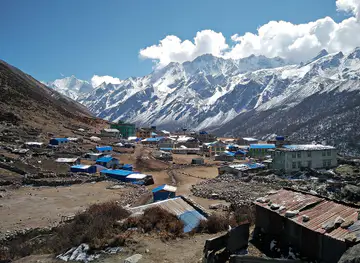
Gokyo Lakes lie in Nepal’s Solukhumbu District, within Sagarmatha National Park and the wider Everest region. The lakes form a chain of glacial tarns on the edge of the Ngozumpa Glacier, Nepal’s longest glacier, with the settlement of Gokyo beside the principal lake, Dudh Pokhari. At an altitude of roughly 4,700 metres, the landscape is defined by thin air, moraine, snowfields and immense Himalayan horizons rather than roads or permanent urban infrastructure. The colour of the water changes with light and weather, while the surrounding slopes lead towards Gokyo Ri and the high passes connecting the Everest and Rolwaling areas.Read more about Gokyo Lakes
Sherpa Heritage and Conservation
Trekking and Mountain Vistas
When is the best time to visit Gokyo Lakes?
Best: June–August · 13–15°C| Month | High (°C) | Rainfall (mm) |
|---|---|---|
| January | -4 | 9 |
| February | -1 | 11 |
| March | 2 | 14 |
| April | 5 | 19 |
| May | 8 | 23 |
| June (best) | 13 | 27 |
| July (best) | 15 | 29 |
| August (best) | 14 | 28 |
| September | 11 | 25 |
| October | 7 | 21 |
| November | 2 | 17 |
| December | -1 | 12 |
Getting to and around Gokyo Lakes
How to get there
Transportation
Best attractions in Gokyo Lakes
The principal attraction is the chain of Gokyo Lakes, with Dudh Pokhari lying beside Gokyo settlement and further glacial lakes extending towards the Ngozumpa Glacier. The turquoise water, surrounding moraines and snow-covered ridges create a landscape that changes markedly with cloud, sunlight and season. A climb of Gokyo Ri provides a broad Himalayan viewpoint, with possible views towards Everest, Lhotse, Makalu and Cho Oyu in clear weather. The trekking approach adds variety: rhododendron and conifer forests lead from the lower Khumbu towards the high valleys of Dole and Machhermo, while Namche Bazaar offers the region’s most substantial cluster of services and cultural interest. Trekkers may continue through the Cho La towards the Everest Base Camp route, although this is a demanding high-pass journey requiring suitable conditions and preparation. Sherpa villages, Buddhist shrines, mani walls, grazing yaks and the stark landscape around Ngozumpa Glacier provide cultural and environmental context throughout the route.
-
Tourist attraction
Sagarmatha National Park Museum
Explore the Sagarmatha National Park Museum in Namche Bazar, a unique blend of culture and nature in the heart of the Himalayas.
-
Bridge
Hillary Bridge
Experience the breathtaking beauty and adventure of Hillary Bridge on the Everest Base Camp Trekking Route in Nepal.
-
Tourist attraction
Deboche
Experience the serene beauty and rich Tibetan culture of Deboche, a tranquil village in the heart of the Himalayas.
-
Tourist attraction
Everest View Point
Experience the breathtaking beauty of the Himalayas at Everest View Point, an essential stop for trekkers and nature lovers seeking unforgettable vistas.


Best landmarks in Gokyo Lakes
Dudh Pokhari is the defining landmark beside Gokyo village, one of a sequence of glacial lakes associated with the Ngozumpa Glacier and the upper Dudh Koshi valley. Gokyo Ri, rising above the settlement, is a prominent natural viewpoint whose summit reveals the scale of the surrounding Himalayan peaks when visibility allows. The Ngozumpa Glacier is another major landmark, its ice and moraine forming a powerful expression of the region’s active glacial landscape. Cho Oyu, one of the world’s highest mountains, dominates views to the north, while Everest, Lhotse and Makalu may appear from elevated points on the route. Human landmarks include the Sherpa settlement of Gokyo, mani walls, prayer flags, chortens and Buddhist shrines that connect the high landscape with local religious traditions. Together these features express both the geological scale and cultural character of Sagarmatha National Park.
-
Tourist attraction
Gokyo Lake
Explore the stunning beauty of Gokyo Lake in Nepal, a glacial gem surrounded by majestic peaks and serene landscapes, perfect for nature lovers and adventurers.
-
Water
Gokyo Lake - Dudh Pokhari
Explore the breathtaking beauty of Gokyo Lake, a pristine glacial lake nestled in the majestic Himalayas, offering serene landscapes and adventure.
-
Hiking area
Lac Gokyo
Experience the breathtaking beauty of Lac Gokyo, a serene glacial lake in the heart of the Himalayas, perfect for hiking and nature enthusiasts.


Explore Gokyo Lakes on the map
Plan your trip on one map. See where the top attractions, landmarks, restaurants and hotels are, and book hotels and experiences in a few clicks.
Best hotels in Gokyo Lakes
Best restaurants in Gokyo Lakes
Dining in the Gokyo Lakes area is closely tied to the trekking lodge system rather than a conventional restaurant scene. Lodges and teahouses in Gokyo and the approach villages generally provide simple meals designed for trekkers, including dal bhat, a Nepalese combination of rice, lentils and accompanying vegetables, as well as soups, noodles, potatoes, eggs, breads and hot drinks. Menus and supplies become more limited as altitude increases, and ingredients are transported along the trail. Namche Bazaar has the widest range of cafés, bakeries and lodge dining on the route, while smaller settlements such as Dole and Machhermo offer more basic choices. Sherpa food traditions, including potato-based dishes and warming soups, reflect the high-altitude environment. Visitors should expect straightforward, filling meals and should not rely on finding extensive choice or specialist dietary products at Gokyo.
-
Lodge
Gokyo Namaste Lodge And Restaurant
Discover the enchanting Gokyo Namaste Lodge and Restaurant in Khumjung – where exquisite cuisine meets breathtaking Himalayan views.
-
Restaurant
Third Pole Summiter Lodge
Discover traditional Nepalese flavors at Third Pole Summiter Lodge amidst stunning Himalayan views.
-
Lodge
Cho Oyu View Lodge and Restaurant
Discover breathtaking views and delightful cuisine at Cho Oyu View Lodge & Restaurant in Khumjung – your perfect Himalayan retreat.
-
Asian
UMAMI TASTE CONER
Discover authentic Asian flavors at UMAMI TASTE CONER in Namche Bazar—where culinary excellence meets breathtaking Himalayan views.


Best bars in Gokyo Lakes
Gokyo Lakes has no nightclub district and very little conventional nightlife. Evenings are centred on the communal dining rooms of trekking lodges, where walkers eat, exchange route information and seek warmth after travelling through the high valleys. Tea, coffee, soft drinks and occasionally locally available alcoholic drinks may be offered by lodges, but selections and opening arrangements vary with supplies, weather and the season. Namche Bazaar has a more developed evening atmosphere, with a broader choice of lodge dining, cafés and informal social venues, although it remains a mountain settlement rather than a late-night entertainment centre. At Gokyo, darkness, cold, altitude and early trekking starts generally shape the evening rhythm, while the surrounding mountains and lakes offer a quiet setting rather than organised entertainment.
-
Pub
Irish Pub
Unwind at the Irish Pub in Namche Bazar, your cozy retreat on the Everest Base Camp trekking route, blending local hospitality with a vibrant atmosphere.
-
Restaurant
Gokyo Namaste Lodge And Restaurant
Discover the flavors of the Himalayas at Gokyo Namaste Lodge, where comfort meets breathtaking mountain views.
-
Bar
Liquid Bar Namche
Experience the vibrant atmosphere of Liquid Bar in Namche, where adventurers unwind with refreshing drinks and the best music in the Himalayas.
-
Bar
Cafe Danphe Bar
Discover the charm of Cafe Danphe Bar in Namche Bazar, where great drinks, local flavors, and stunning Himalayan views come together.


Best shops in Gokyo Lakes
Shopping at Gokyo Lakes is limited to the modest supplies and trekking necessities available through local lodges or small settlement shops. Visitors should obtain specialist clothing, equipment, medication, snacks and other essential items in Kathmandu, Lukla or Namche Bazaar rather than expecting a developed retail scene at altitude. Namche is the main commercial centre on the approach, with trekking equipment, practical supplies, souvenirs and locally produced goods available in a compact mountain-town setting. Some visitors purchase handmade woollen items, prayer-related crafts or small souvenirs associated with Sherpa culture, but religious objects should be treated respectfully and not handled as casual commodities. Shopping in the upper valley is constrained by transport costs, limited storage and seasonal access, so local purchases are best kept practical and considerate of the communities that supply the route.
-
Hotel
Gokyo Resort
Experience the magic of the Himalayas at Gokyo Resort, your ultimate getaway for adventure and relaxation in Nepal.
-
Lodge
Gokyo Namaste Lodge And Restaurant
Experience the best of local flavors and stunning Himalayan views at Gokyo Namaste Lodge and Restaurant, your perfect retreat in Khumjung.
-
Outdoor clothing and equipment shop
SHERPA ADVENTURE GEAR, NAMCHE
Discover top-quality outdoor gear at Sherpa Adventure Gear, the essential stop for trekkers and climbers in Namche Bazar, Nepal.
-
Outdoor clothing and equipment shop
Mountain Sherpa Gear
Discover quality outdoor gear at Mountain Sherpa Gear, your essential stop in Namche Bazaar for trekking the Everest Base Camp.


Get your free copy of our complete guide to Gokyo Lakes, delivered straight to you.
Everything on this page, from attractions and restaurants to essentials and local phrases, in one PDF you can read offline, print or share.
Already have an account? Sign in
Your Gokyo Lakes guide is ready.
We'll send it to · Not you? Sign out

Getting your guide ready…
We are putting together a fresh copy of the Gokyo Lakes guide. This can take up to a minute.
This can take a few moments. If your browser asks, choose Allow so the download can start. You'll find the guide in your Downloads folder.
Nothing happened? Download it again
Sorry, the guide is taking longer than usual. Please try again in a minute, or get it by email instead.
Gokyo Lakes essentials
Currency and Payment
Safety
Emergency Situations
Do's and Don'ts
Local Tips
From Eve
Local phrases worth knowing
You don't need to get them perfect. A few words go a long way, and locals appreciate the effort.
Basics
| English | Local | Say it |
|---|---|---|
| Hello | नमस्ते | [namaste] |
| Goodbye | फेरी भेटौं | [feri bhetou] |
| Yes | हो | [ho] |
| No | होईन | [hoiin] |
| Please/You're welcome | कृपया | [krupaya] |
| Thank you | धन्यवाद | [dhanyavad] |
| Excuse me/Sorry | माफ गर्नुहोस् | [maaf garnuhos] |
| How are you? | तपाइँलाई कस्तो छ? | [tapailai kasto chha?] |
| Fine. And you? | राम्रो, तपाइँलाई? | [ramro, tapailai?] |
| Do you speak English? | तपाइँले अंग्रेजी बोल्नुहुन्छ? | [tapainle angreji bolnuhunchha?] |
| I don't understand | मैले सम्झिन | [maile samjhin] |
Eating & Drinking
| English | Local | Say it |
|---|---|---|
| I'd like to see the menu, please | कृपया मेनू हेर्न चाहन्छु | [krupaya menu hern chahanchu] |
| I don't eat meat | म भांसामा खान्न छैन | [ma bhasama khann chain] |
| Cheers! | चियर्स! | [chears!] |
| I would like to pay, please | कृपया भुक्तानी गर्न चाहन्छु | [krupaya bhuktani garun chahanchu] |
Emergencies
| English | Local | Say it |
|---|---|---|
| Help! | मदद! | [madad!] |
| Go away! | दूर हिड्नुहोस्! | [dur hidnuhos!] |
| Call the Police! | प्रहरीलाई बुलाउनुहोस्! | [praharilai bulaunuhos!] |
| Call a doctor! | डाक्टरलाई बुलाउनुहोस्! | [daktarlai bulaunuhos!] |
| I'm lost | म खोइएको छु | [ma khoieko chu] |
| I'm ill | म अस्वस्थ छु | [ma asvasth chu] |
Shopping
| English | Local | Say it |
|---|---|---|
| I'd like to buy... | म किन्न चाहन्छु... | [ma kinn chahanchu...] |
| I'm just looking | म केवल हेर्न आएको छु | [ma keval hern aeko chu] |
| How much is it? | यो कति हो? | [yo kati ho?] |
| That's too expensive | यो धेरै महँगो छ | [yo dherai mahango chha] |
| Can you lower the price? | के तपाइले मूल्य हटाउन सक्नुहुन्छ? | [ke tapaile mulya hataun saknuhunchha?] |
Time & Numbers
| English | Local | Say it |
|---|---|---|
| What time is it? | कति बजे हो? | [kati baje ho?] |
| It's one o'clock | एक बजे भएको छ | [ek baje bhaeko chha] |
| Half past (10) | दसबजे देखि आधा | [dasbaje dekhi aadha] |
| Morning | बिहान | [bihan] |
| Afternoon | दिउँसो | [diunso] |
| Evening | साँझ | [saanjh] |
| Yesterday | हिजो | [hijo] |
| Today | आज | [aaj] |
| Tomorrow | भोलि | [bholi] |
| 1 | एक | [ek] |
| 2 | दुइ | [dui] |
| 3 | तीन | [tin] |
| 4 | चार | [chaar] |
| 5 | पाँच | [paanch] |
| 6 | छ | [chha] |
| 7 | सात | [saat] |
| 8 | आठ | [aath] |
| 9 | नौ | [nau] |
| 10 | दस | [das] |
Transport & Directions
| English | Local | Say it |
|---|---|---|
| Where's a/the...? | ... कहाँ छ? | [... kahan chha?] |
| What's the address? | ठेगाना के हो? | [thegana ke ho?] |
| Can you show me (on the map)? | के तपाइले मलाई देखाउन सक्नुहुन्छ? (नक्सामा) | [ke tapaile malai dekhaun saknuhunchha? (naksama)] |
| When's the next (bus)? | अर्को कति बजे? (बस) | [arko kati baje? (bas)] |
| A ticket (to ....) | एक टिकट (... को लागि) | [ek ticket (... ko lagi)] |
History of Gokyo Lakes
Glacial Formation of the Lakes
Gokyo’s lakes are products of the high Himalayan glacial environment rather than human construction. Glacial ice, moraine deposits and meltwater have shaped a chain of water bodies along the Ngozumpa Glacier and its surrounding valleys. Dudh Pokhari, beside Gokyo village, is the best-known lake, while other lakes extend northwards towards the glacier and the Cho Oyu region. Their form and water levels remain linked to seasonal melt, snowfall and long-term changes in the cryosphere. This geological and environmental setting explains both the lakes’ vivid appearance and the demanding terrain encountered on the trekking route.
Sherpa Settlement in Khumbu
The upper Khumbu has long been associated with Sherpa communities whose ancestors migrated south from the Tibetan plateau over several centuries. In the Gokyo area, settlement and movement have traditionally been influenced by altitude, harsh winters, limited cultivation and the seasonal herding of yaks. Villages, Buddhist shrines, mani stones and prayer flags reflect Tibetan Buddhist traditions adapted to Himalayan conditions. Gokyo developed as a small seasonal and trekking-related settlement, while older communities such as Namche Bazaar became important centres for trade, livestock movement and exchange between the high valleys and lower regions.
Trade, Herding and Mountain Crossings
Before modern trekking became the principal source of outside visitors, the Khumbu economy depended heavily on trans-Himalayan exchange, agriculture at suitable elevations and pastoralism. High passes and glacier valleys connected communities, although routes were difficult and seasonal. Yaks remain important for transport and livestock management, particularly in the upper valleys where roads are absent. The trail to Gokyo is therefore part of a wider cultural landscape of movement rather than simply a recreational path. Trade, religious journeys and seasonal herding helped maintain links between settlements long before the region acquired an international reputation for trekking.
Protection of Sagarmatha National Park
Sagarmatha National Park was established in 1976 to protect the landscapes, wildlife and cultural heritage of the high Khumbu, including the Gokyo Lakes area. The park encompasses glaciers, alpine habitats, forests at lower elevations and settlements whose residents continue to live within the protected landscape. In 1979, Sagarmatha National Park was inscribed as a UNESCO World Heritage Site for its exceptional mountain environment and Sherpa culture. Conservation has since had to balance tourism, waste management, grazing, infrastructure needs and the effects of a changing climate on glaciers, trails and high-altitude wetlands.
The Growth of Trekking Tourism
International interest in the Everest region expanded after mountaineering expeditions and the successful ascent of Everest in 1953, gradually transforming the Khumbu economy. The route to Gokyo became valued as an alternative to the more heavily travelled Everest Base Camp approach and as a connection to the Cho La and other high passes. Lodges, porter services and guiding developed along established trails, while air access to Lukla reduced the time needed to reach the trekking region. Tourism now supports many local households, although the high-altitude environment remains sensitive to waste, overcrowding, warming temperatures and limited services.
Gokyo Lakes in Photos
Browse through our photo collection highlighting the charm and character of the destination.
Cities in Gokyo Lakes
The towns and cities of Gokyo Lakes, and the easiest places to base yourself.

Swipe for more cities
Neighbouring destination travel guides
The closest destinations to Gokyo Lakes, if you have time for more than one.
-

-

-

-
-


Swipe for more destinations
Explore more

Explore more of Sagarmatha Zone
Sagarmatha Zone combines Everest trekking, Sherpa Buddhist culture, glacial valleys and Nepal’s contrasting middle hills and Terai landscapes.
Explore Sagarmatha Zone
Explore more of Nepal
Discover Nepal: A land of towering peaks, spiritual harmony, and vibrant culture, offering endless adventures and serene escapes for every traveler.
Explore Nepal