

La Soufriere Travel Guide - Free Web & App
Your ultimate guide to La Soufriere. Discover top landmarks, proposed trips, and local tips. Free on the web or via the Evendo companion app.


La Soufriere, Saint Vincent and the Grenadines, offers volcanic landscapes, crater hikes, rainforest, ash-terraced slopes and dramatic island views.
A Mountain Shaped by Fire
La Soufriere rises to 1,234 metres at the northern end of Saint Vincent, dominating the island’s skyline and forming one of the Caribbean’s most active volcanic landscapes. Its slopes change from lower cultivated land and forest to rugged upper terrain, ash fields and the stark margins of a summit crater. The volcano is not a conventional resort attraction: there is no settlement or extensive visitor infrastructure on the mountain itself, and conditions, access arrangements and exclusion zones can change after volcanic activity.Read more about La Soufriere
Walking and Natural Heritage
Gateway Communities
When is the best time to visit La Soufriere?
Best: May–July · 30°C| Month | High (°C) | Rainfall (mm) |
|---|---|---|
| January | 29 | 191 |
| February | 30 | 147 |
| March | 30 | 125 |
| April | 30 | 53 |
| May (best) | 30 | 35 |
| June (best) | 30 | 26 |
| July (best) | 30 | 32 |
| August | 30 | 37 |
| September | 30 | 46 |
| October | 30 | 71 |
| November | 30 | 90 |
| December | 30 | 147 |
Getting to and around La Soufriere
How to get there
Transportation
Best attractions in La Soufriere
The principal attraction is La Soufriere itself, whose ascent leads through changing vegetation and exposed volcanic terrain towards the summit crater, subject to official access advice. The mountain’s northern slopes reveal the scale of Saint Vincent’s interior, while clear intervals can open views towards the coast and neighbouring islands. The surrounding countryside is a mixture of small settlements, cultivated valleys and recovering land affected by the 2021 eruption. Nearby northern sights such as Dark View Falls are separate attractions rather than features of the summit area, but can complement a visit when approached from the west and when local conditions permit. Georgetown and Chateaubelair offer contrasting gateways into the island’s rural north, with coastal scenery, fishing activity and access arrangements for mountain excursions. Attractions here are primarily geological and environmental rather than museum-based, and their character depends strongly on weather, volcanic restrictions, road conditions and the evolving recovery of the landscape.
-
National park
Chatoyer National Park
Explore the lush landscapes and wildlife of Chatoyer National Park, a Caribbean paradise for nature lovers and adventure seekers alike.
-
Falls Of Baleine
Explore the breathtaking Falls of Baleine, a natural wonder in Wallibou, surrounded by lush landscapes and perfect for adventure and relaxation.
-
National park
The La Soufrière National Park
Explore the stunning landscapes and rich biodiversity of La Soufrière National Park, a UNESCO World Heritage site in Saint Vincent, perfect for adventure seekers.
-
Tourist attraction
Owia Waterfall
Discover the breathtaking beauty of Owia Waterfall, a serene natural attraction in Saint Vincent that offers a perfect escape into nature.


Best landmarks in La Soufriere
La Soufriere’s summit crater is the defining natural landmark, a visible expression of the volcano’s continuing activity and a place whose access must always follow current official guidance. The mountain’s broad, ash-marked upper slopes preserve evidence of successive eruptions, while lower ridges and valleys show how volcanic terrain supports forest and cultivation. The northern coastline and the communities around Georgetown and Chateaubelair form important geographical reference points, linking the isolated summit to the lived landscape of Saint Vincent. Dark View Falls, west of the mountain, is a notable nearby landmark rather than part of the crater itself. The most significant human landmarks in the wider area are the settlements, roads and agricultural clearings shaped by repeated evacuation, rebuilding and adaptation after eruptions, rather than grand monuments concentrated at the volcano.
-
Volcano
La Soufrière
Discover the breathtaking views and unique biodiversity of La Soufrière, an active volcano in St. Vincent that offers unforgettable hiking adventures.
-
Hiking area
La Soufriere Volcano
Discover the breathtaking beauty of La Soufriere Volcano, a stunning hiking destination in Saint Vincent offering panoramic views and unique ecological experiences.
-
Hiking area
La Soufrière Volcano
Experience the thrill of hiking La Soufrière Volcano, an active marvel offering stunning views and rich biodiversity on the beautiful island of St. Vincent.
-
National park
The La Soufrière National Park
Discover the breathtaking beauty of La Soufrière National Park, where lush landscapes meet volcanic wonders in St. Vincent.


Explore La Soufriere on the map
Plan your trip on one map. See where the top attractions, landmarks, restaurants and hotels are, and book hotels and experiences in a few clicks.
Best hotels in La Soufriere
Best restaurants in La Soufriere
There is no restaurant district on La Soufriere and no dining infrastructure on the upper mountain, so hikers need to arrange food and water before setting out. Eating options are concentrated in Saint Vincent’s settlements, with Georgetown and Chateaubelair serving as useful northern bases for simple meals, shops and locally prepared food, although opening times and choice can be limited. Across the island, Vincentian cooking draws on provisions such as breadfruit, plantain, cassava and sweet potato, alongside fish, poultry and stewed meats, with Caribbean seasonings and locally grown produce. Small eateries and roadside vendors may provide more direct contact with everyday food culture than formal dining rooms. Visitors staying in guesthouses or rural accommodation should ask about meals in advance, particularly when using a remote trailhead or planning an early start.
-
Restaurant
Beach Front Restaurant & Bar
Experience exquisite local cuisine and breathtaking ocean views at Beach Front Restaurant & Bar – a must-visit destination for every tourist.
-
 Barbecue
Babloz wings and tings
Discover the vibrant flavors of Caribbean barbecue at Babloz Wings and Tings in Georgetown - a must-visit culinary destination.
-
Restaurant
Krave Lounge Restaurant & Bar
Discover exquisite Caribbean cuisine at Krave Lounge Restaurant & Bar in Chateaubelair – where every meal is a celebration of flavor.


Best bars in La Soufriere
La Soufriere is a rural volcanic destination rather than a nightlife centre, and there are no clubs or dedicated entertainment venues on the mountain. Evening activity is generally quiet, with drinks, conversation and local hospitality found in bars, rum shops, restaurants and guest accommodation in surrounding settlements. Georgetown and Chateaubelair may offer informal evening options, but the atmosphere is primarily community-focused and opening patterns can vary. Larger towns elsewhere on Saint Vincent provide a broader choice of places to spend an evening, although they are outside the immediate La Soufriere area. After a mountain excursion, visitors are more likely to encounter a relaxed local gathering or music in a small venue than a scheduled nightlife programme, so evening plans should remain flexible and respectful of residential communities.
-
Bar
G-SPOT BAR
Experience the vibrant atmosphere and refreshing drinks at G-SPOT BAR in New Sandy Bay Village, a must-visit spot for travelers seeking fun and relaxation.
-
Bar
Millers Bar
Experience the lively ambiance and refreshing drinks at Millers Bar in New Sandy Bay Village, the perfect spot for relaxation and local culture.
-
Bar
Wallo’s bar
Experience the vibrant essence of Georgetown at Wallo's Bar, where refreshing drinks and lively atmosphere await every visitor.
-
Bar
Cupper's bar
Experience the vibrant Caribbean nightlife at Cupper's Bar in Georgetown, where delicious cocktails and friendly locals await.


Best nightclubs in La Soufriere
La Soufriere is a rural volcanic destination rather than a nightlife centre, and there are no clubs or dedicated entertainment venues on the mountain. Evening activity is generally quiet, with drinks, conversation and local hospitality found in bars, rum shops, restaurants and guest accommodation in surrounding settlements. Georgetown and Chateaubelair may offer informal evening options, but the atmosphere is primarily community-focused and opening patterns can vary. Larger towns elsewhere on Saint Vincent provide a broader choice of places to spend an evening, although they are outside the immediate La Soufriere area. After a mountain excursion, visitors are more likely to encounter a relaxed local gathering or music in a small venue than a scheduled nightlife programme, so evening plans should remain flexible and respectful of residential communities.
-
Bar
G-SPOT BAR
Discover vibrant nightlife at G-SPOT BAR in New Sandy Bay Village, where great drinks and lively entertainment await every visitor.
-
Night club
SPOTLIGHT STADIUM
Experience the electrifying nightlife at Spotlight Stadium, Georgetown's top destination for music, dance, and unforgettable fun.
-
Bar
Summit bar and snackette
Experience the local charm and flavors at Summit Bar and Snackette in Owia, where relaxation meets tropical vibes.
-
Bar
SKY LOUNGE BAR
Discover the vibrant atmosphere of Sky Lounge Bar in New Sandy Bay Village, where exquisite cocktails meet stunning views in a tropical paradise.


Best shops in La Soufriere
Shopping opportunities are limited in the immediate La Soufriere area because the mountain is an active rural landscape rather than a commercial centre. Visitors should obtain hiking essentials, snacks, water, sun protection and cash in larger settlements before travelling to a trailhead. Georgetown and Chateaubelair have local shops and everyday services, while craft items, artworks, food products and souvenirs are more readily found through businesses and markets in the island’s larger towns. Regional purchases may include locally produced fruit and provisions, Caribbean food products, handmade items and small-scale artwork, although stock and opening times vary. Buying from local producers and artisans can support communities affected by volcanic disruption, but visitors should not remove rocks, ash or plants from the mountain as souvenirs. There is no extensive shopping street or permanent retail cluster at La Soufriere itself.
-
Bakery
Garifuna Bakery
Experience authentic Caribbean flavors at Garifuna Bakery, where traditional recipes meet freshly baked goodness in New Sandy Bay Village.
-
Cake shop
Rica's Bakery
Discover the flavors of the Caribbean at Rica's Bakery, where every cake tells a story and every bite is a journey.
-
Store
Overdose Hideout Grocery and Bar
Experience local flavors and the vibrant atmosphere at Overdose Hideout Grocery and Bar in Georgetown, your gateway to Caribbean culinary delights.
-
Boutique
M & J Boutique
Explore M & J Boutique in New Sandy Bay Village for a unique selection of local fashion, accessories, and an inviting shopping experience.


Get your free copy of our complete guide to La Soufriere, delivered straight to you.
Everything on this page, from attractions and restaurants to essentials and local phrases, in one PDF you can read offline, print or share.
Already have an account? Sign in
Your La Soufriere guide is ready.
We'll send it to · Not you? Sign out

Getting your guide ready…
We are putting together a fresh copy of the La Soufriere guide. This can take up to a minute.
This can take a few moments. If your browser asks, choose Allow so the download can start. You'll find the guide in your Downloads folder.
Nothing happened? Download it again
Sorry, the guide is taking longer than usual. Please try again in a minute, or get it by email instead.
La Soufriere essentials
Currency and Payment
Safety
Emergency Situations
Do's and Don'ts
Local Tips
From Eve
Local phrases worth knowing
You don't need to get them perfect. A few words go a long way, and locals appreciate the effort.
Basics
| English | Local | Say it |
|---|---|---|
| Hello | Wah Gwan | [Wah Gwan] |
| Goodbye | Later | [Later] |
| Yes | Yah man | [Yah man] |
| No | Nah man | [Nah man] |
| Please/You're welcome | S'il vous plait | [See voo play] |
| Thank you | Tank yuh | [Tank yuh] |
| Excuse me/Sorry | Sarry | [Sarry] |
| How are you? | Wah yuh say? | [Wah yuh say?] |
| Fine. And you? | Mi deh yah. An yuh? | [Mi deh yah. An yuh?] |
| Do you speak English? | Yuh speak English? | [Yuh speak English?] |
| I don't understand | Mi nah undastan | [Mi nah undastan] |
Eating & Drinking
| English | Local | Say it |
|---|---|---|
| I'd like to see the menu, please | Mi wah see di menu, please | [Mi wah see di menu, please] |
| I don't eat meat | Mi nuh eat meat | [Mi nuh eat meat] |
| Cheers! | Cheers! | [Cheers!] |
| I would like to pay, please | Mi wah pay, please | [Mi wah pay, please] |
Emergencies
| English | Local | Say it |
|---|---|---|
| Help! | Help! | [Help!] |
| Go away! | Move from yah! | [Move from yah!] |
| Call the Police! | Call di Police! | [Call di Police!] |
| Call a doctor! | Call a docta! | [Call a docta!] |
| I'm lost | Mi lost | [Mi lost] |
| I'm ill | Mi sick | [Mi sick] |
Shopping
| English | Local | Say it |
|---|---|---|
| I'd like to buy... | Mi wah buy... | [Mi wah buy...] |
| I'm just looking | Mi just a look | [Mi just a look] |
| How much is it? | How much it deh? | [How much it deh?] |
| That's too expensive | Dat too much money | [Dat too much money] |
| Can you lower the price? | Yuh can drop di price? | [Yuh can drop di price?] |
Time & Numbers
| English | Local | Say it |
|---|---|---|
| What time is it? | Wah time it be? | [Wah time it be?] |
| It's one o'clock | It one o'clock | [It one o'clock] |
| Half past (10) | Haaf pass ten | [Haaf pass ten] |
| Morning | Mawnin | [Mawnin] |
| Afternoon | Aftanoon | [Aftanoon] |
| Evening | Eevinin | [Eevinin] |
| Yesterday | Yestadeh | [Yestadeh] |
| Today | Today | [Today] |
| Tomorrow | Tamara | [Tamara] |
| 1 | One | [One] |
| 2 | Two | [Two] |
| 3 | Tree | [Tree] |
| 4 | Fo | [Fo] |
| 5 | Fi | [Fi] |
| 6 | Six | [Six] |
| 7 | Seven | [Seven] |
| 8 | Eight | [Eight] |
| 9 | Nine | [Nine] |
| 10 | Ten | [Ten] |
Transport & Directions
| English | Local | Say it |
|---|---|---|
| Where's a/the...? | Wey di... | [Wey di...] |
| What's the address? | Wah di address deh? | [Wah di address deh?] |
| Can you show me (on the map)? | Yuh can show mi (pan di map)? | [Yuh can show mi (pan di map)?] |
| When's the next (bus)? | When di nex (bus) deh? | [When di nex (bus) deh?] |
| A ticket (to ....) | A ticket (to ....) | [A ticket (to ....)] |
History of La Soufriere
A Young Caribbean Volcano
La Soufriere is a stratovolcano formed by the volcanic processes that built Saint Vincent in the Lesser Antilles arc. Its steep profile, summit crater and layers of lava, ash and other erupted material record repeated eruptions rather than a single moment of formation. The mountain is the island’s highest point and remains an active geological system. The upper slopes are consequently shaped by both long-term weathering and comparatively recent volcanic deposits, while lower elevations support forests, farms and settlements that occupy terrain influenced by the volcano’s drainage and soils.
Indigenous Settlement and Island Communities
Saint Vincent was inhabited by Indigenous peoples before European colonisation, including Island Carib communities whose presence remains important to the island’s history and identity. European settlement and plantation agriculture later transformed coastal and valley landscapes, while resistance to colonial rule continued in the north and west. The Garifuna, descended from Indigenous Caribbean and African communities, were forcibly removed from Saint Vincent in the late eighteenth century after prolonged conflict with British forces. Although La Soufriere itself has remained largely unsettled at high elevation, the mountain has long influenced the lives, agriculture and movement of communities around northern Saint Vincent.
Eruptions and Landscape Change
La Soufriere has erupted repeatedly during the historical period, with major episodes recorded in 1718, 1812, 1814, 1902–03 and 1979. The 1902–03 eruption caused extensive destruction and loss of life, while the 1979 eruption prompted evacuations and demonstrated the continuing risk to communities on the northern part of the island. Ash, mudflows and volcanic debris have repeatedly altered valleys and coastal areas, and each eruption has left a new layer of geological evidence on the mountain. These events also established volcanic monitoring and preparedness as permanent features of Saint Vincent’s public life.
The 2021 Eruption and Modern Monitoring
After a period of renewed unrest, La Soufriere entered an explosive phase in April 2021. Ashfall affected much of Saint Vincent, communities were evacuated and adjoining Caribbean islands experienced the effects of the eruption through airborne ash and disruption. The event reinforced the importance of scientific monitoring, exclusion zones, evacuation planning and public communication. Today, access to the upper mountain must be understood in the context of this recent eruption: trails and permissions may be altered by official advice, and the landscape continues to recover while remaining volcanically active.
La Soufriere in Photos
Browse through our photo collection highlighting the charm and character of the destination.
Cities in La Soufriere
The towns and cities of La Soufriere, and the easiest places to base yourself.
-

-


Swipe for more cities
Neighbouring destination travel guides
The closest destinations to La Soufriere, if you have time for more than one.
-

-

-

-

-


Swipe for more destinations
Explore more

Explore more of Saint David
Explore Saint David in Saint Vincent and the Grenadines for forested valleys, Dark View Falls, Chateaubelair and the historic Wallilabou coast.
Explore Saint David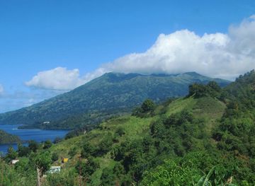
Explore more of Saint Vincent and the Grenadines
Discover the enchanting islands of Saint Vincent and the Grenadines, where lush rainforests, pristine beaches, and vibrant culture create an unforgettable Caribbean experience.
Explore Saint Vincent and the Grenadines