Background

Mam Tor: The Mother Hill of the Peak District

Discover Mam Tor, the iconic 'Mother Hill' of the Peak District, offering ancient history, dramatic landslips, and panoramic views over Hope Valley.

4.8

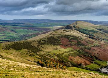
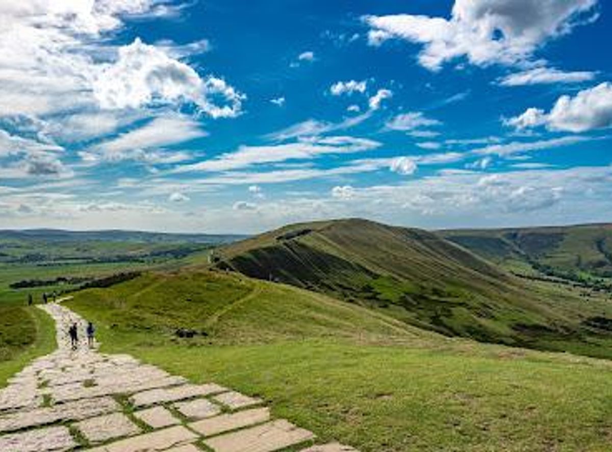
Mam Tor is a striking 517-meter hill near Castleton in the High Peak of Derbyshire, England, known as the 'Mother Hill' due to its frequent landslips creating a unique landscape. It offers panoramic views over Hope Valley and Edale, crowned by ancient Bronze and Iron Age hill forts. The hill is a gateway to the famous Great Ridge walk, surrounded by dramatic geology and historic caves, making it a must-visit landmark in the Peak District National Park.

A brief summary to Mam Tor

  • Hope Valley, GB
  • Duration: 1 to 4 hours
  • Free
  • Environment icon Outdoor
  • Mobile reception: 4 out of 5

Local tips

  • Start your ascent from the National Trust car park at Mam Nick for a well-paved and accessible route to the summit.
  • Bring a camera to capture stunning panoramic views, especially during sunrise or when the valley is shrouded in mist.
  • Wear sturdy footwear as some sections of the Great Ridge walk can be steep and rocky, particularly near Back Tor.
  • Explore nearby show caves like Blue John Cavern and Peak Cavern to experience the region’s fascinating mining history.
  • Visit the 'Broken Road' beneath Mam Tor to see the effects of historic landslips and the hill’s ongoing geological activity.
widget icon

Getting There

  • Train and Walk

    Take a train to Hope station from Sheffield or Manchester, with journey times between 45 to 90 minutes. From Hope, it is approximately a 1.5 to 2-hour walk to Mam Tor via well-marked trails. The walk involves moderate terrain with some steep sections, suitable for most walkers with reasonable fitness. This option is cost-effective, with train fares typically ranging from £10 to £20 one way.

  • Car Access

    Drive to the National Trust car park at Mam Nick near Castleton, about 20 minutes from Hope Valley village. Parking requires payment via an app or pay-on-site system, with fees around £5 to £8 for a day. The car park provides direct access to the paved path up Mam Tor, making it the easiest route for those with limited time or mobility.

  • Bus and Hike

    Use local bus services from Sheffield or Chesterfield to Castleton or Hope, with journey times ranging from 1 to 1.5 hours depending on connections. From either village, a hike of 1 to 2 hours leads to Mam Tor, crossing varied terrain. Bus fares typically range from £5 to £12. Note that bus services may be less frequent on weekends or holidays.

Mam Tor location weather suitability

  • Weather icon Any Weather
  • Weather icon Clear Skies
  • Weather icon Rain / Wet Weather
  • Weather icon Windy Conditions
  • Weather icon Mild Temperatures
  • Weather icon Cold Weather

Unlock the Best of Mam Tor

Buy tickets

    No tickets available

Book tours with entry

    No tours available

Book tours without entry

    No tours available

Discover more about Mam Tor

A Geological and Historical Marvel

Mam Tor, standing at 517 meters (1,696 feet), is a prominent hill near Castleton in Derbyshire’s High Peak. Its name, meaning 'Mother Hill,' reflects its dynamic landscape shaped by frequent landslips on its eastern face. These movements have formed numerous smaller hills beneath it, earning Mam Tor the nickname 'Shivering Mountain.' The unstable shale layers beneath cause these slips, which famously led to the closure of the A625 road in 1979, now known as the 'Broken Road,' a visible testament to the hill’s restless nature. The summit is rich in archaeological significance, featuring a late Bronze Age and early Iron Age univallate hill fort, one of the earliest and largest in Britain, covering around 16 acres. Nearby, two Bronze Age bowl barrows add to the historical landscape. Excavations have revealed an Iron Age village with over a hundred timber roundhouses, showcasing ancient human settlement and activity on the hill.

Scenic Vistas and Natural Beauty

From the summit, visitors are rewarded with breathtaking 360-degree views. To the south lies the picturesque Hope Valley, while to the north, the Edale Valley stretches out towards Kinder Scout and the Derwent Moors. On clear days, distant cities such as Manchester and Sheffield can be glimpsed on the horizon. The hill’s position on the boundary between the gritstone edges of the Dark Peak and the limestone plateaux of the White Peak offers a striking contrast in geological features. The Great Ridge, extending roughly 3 kilometers from Mam Tor to Lose Hill, is a celebrated ridge walk that provides continuously stunning panoramas of the surrounding valleys and tors like Hollins Cross and Back Tor. The well-paved path along the ridge helps preserve the landscape from erosion despite heavy foot traffic, making it accessible for many walkers.

Geological Wonders and Nearby Attractions

Mam Tor’s geology is complemented by nearby natural wonders such as Winnats Pass, a dramatic limestone gorge favored by photographers for its towering cliffs and narrow winding road. At the base of Mam Tor lie several famous show caves, including Blue John Cavern, Speedwell Cavern, Peak Cavern, and Treak Cliff Cavern, where minerals like lead and the rare Blue John stone were historically mined. The 'Broken Road' beneath Mam Tor, closed due to landslides, is itself a point of interest, illustrating the ongoing geological activity. Layers of tarmac and gravel up to two meters thick reveal the extensive efforts to maintain this route before its abandonment.

Walking and Outdoor Experience

Despite its height, Mam Tor is considered a relatively easy climb, especially from the National Trust car park at Mam Nick, where a well-paved path leads to the summit. The popular Mam Tor Circular Walk spans about 5 kilometers and typically takes around two hours, offering a moderate challenge with rewarding views. The Great Ridge walk from Mam Tor to Lose Hill is a highlight for hikers, featuring varied terrain and spectacular scenery. Hollins Cross, a key junction on the ridge, has historical significance as part of the traditional coffin route between Edale and Hope.

Cultural and Natural Heritage

Mam Tor embodies a rich cultural heritage with its ancient hill forts and Iron Age village remains, set within the stunning natural environment of the Peak District National Park. It serves as a link between the Dark Peak’s gritstone and the White Peak’s limestone, symbolizing the geological diversity of the region. Visitors can immerse themselves in the landscape’s stories, from prehistoric settlements to the enduring geological processes shaping the hill. The area’s caves, ridges, and valleys offer diverse experiences for nature lovers, history enthusiasts, and photographers alike.

Photographic and Seasonal Highlights

The summit of Mam Tor often rises above the cloud line, providing spectacular views above mist and cloud inversions common in the Hope Valley. Photographers prize the location for its panoramic vistas, especially during sunrise and sunset, and for capturing the dramatic interplay of light and shadow across the ridges and valleys. Seasonal changes bring varied atmospheres, from lush green summers to snow-dusted winters, each enhancing the hill’s visual appeal. The well-maintained paths and nearby amenities encourage visitors year-round, with the landscape offering unique moods and photographic opportunities in all seasons.

Busiest months of the year

Busiest hours of the day

Popular Experiences near Mam Tor

Popular Hotels near Mam Tor

Select Currency