Arches and Canyonlands NP Self-Guided Driving Audio Bundle Tour
Highlights
- Marvel at gravity-defying formations at Arches
- Take in the sweeping red vistas of Canyonlands
- Unforgettable hikes through classic Western landscapes
- Discover nature in its most unexpected form
- Make memories you'll never forget
-
Duration 5-6 hours
-
Audio guide in English
-
Offline map access
-
Purchase per vehicle
-
Flexible start and pause
-
Comprehensive route included
Experience the breathtaking beauty and epic landscapes of Arches and Canyonlands National Parks with this self-driving bundle tour. Journey through the high desert and witness gravity-defying rock formations at Arches, while marveling at the sweeping red vistas of Canyonlands. Immerse yourself in the legends and stories behind these iconic parks as you embark on unforgettable hikes through their rugged terrain. With the Tour Guide App by Action, you’ll have access to an immersive audio tour that guides you through the highlights of each park. From the iconic Delicate Arch to the Fiery Furnace and Sand Dune Arch, discover the wonders of nature in its most unexpected forms. This tour offers a lifetime of memories and is perfect for travelers seeking adventure, natural beauty, and a deeper connection with the great outdoors. Don’t miss out on this incredible opportunity to explore Arches and Canyonlands National Parks. Book your self-driving bundle tour today!
At a Glance
-
Free cancellation
-
7 hours
-
Instant Confirmation
-
Available in English
-
Mobile voucher
-
Private Tour
-
Family friendly
Featured Reviews
Explore Arches and Canyonlands NP at your own pace with an engaging audio guide, uncovering the wonders of the high desert landscape.
Included
-
Perfect narrator: nothing can beat listening to a great voice. Proven with tons of rave reviews!
-
Engaging storytelling: Uncover unique tales, history, and facts for a memorable journey!
-
Hands-free: audio stories play on their own based on your location. Easy to use!
-
Offline maps: no signal, no problem! Works perfectly without cellular or wifi.
-
Comprehensive route and stops: See it all, miss nothing, leave no stone unturned!
-
Go at your own pace: Start anytime, pause anywhere, enjoy breaks for snacks and photos freely!
-
Great value: purchase per car, not per person. More affordable than bus or guided tours!
-
Easy-to-use app: download Action’s Tour Guide App onto your phone
Excluded
-
Attraction passes, entry tickets, or reservations
Meeting Point
Begin from Moab Giants, 112 West UT-313, Moab, UT 84532, USA. After booking the tour, search your emails and texts for "audio tour". Your tour is VALID FOR ONE YEAR so follow these instructions NOW to finish setting up the tour while you have Wi-Fi/data. Do NOT wait until you are onsite.
112 UT-313, Moab, UT 84532 , United States
End Point
Begin from Moab Giants, 112 West UT-313, Moab, UT 84532, USA. After booking the tour, search your emails and texts for "audio tour". Your tour is VALID FOR ONE YEAR so follow these instructions NOW to finish setting up the tour while you have Wi-Fi/data. Do NOT wait until you are onsite.
112 UT-313, Moab, UT 84532 , United States
What to expect
Meeting Point
Begin from Arches National Park Visitor Center, Moab, UT 84532, USA. After booking the tour, search your emails and texts for "audio tour". Your tour is VALID FOR ONE YEAR so follow these instructions NOW to finish setting up the tour while you have Wi-Fi/data. Do NOT wait until you are onsite.
Arches Visitor Center
Our adventure into the astounding Arches begins just before the park's entrance and visitor center. We're about to see stunning natural monuments, unlikely rock formations, and alien, ancient landscapes. Buy once, use for one year! Ideal for extended visits and return trips over the next 12 months. The tour is over 28+ miles long per tour, with more than 49+ audio stories per tour, and takes about 2-3 hours per tour to complete.
Moab Fault Overlook
Moab’s Fault is a six million-year-old crack in the earth’s crust. As we continue driving, we'll see this fault and learn about the geologic pressures that have formed the landscape of Arches.
La Sal Mountains Viewpoint
The La Sal Mountains are the second-highest mountain range in Utah. Their highest peak, which you can see toward the center of the range, is almost 13,000 feet tall. We'll pause our drive through Arches to admire the mountains and learn about the Spanish settlers who pushed out the Ute and Paiute tribes.
Three Gossips
As we continue driving through Arches, we'll pass the iconic Three Gossips formation.
Courthouse Towers Viewpoint And Trailhead
This brings us to another vista point, where we'll see the Organ, Courthouse, Sheep Rock, and more.
Petrified Dunes Viewpoint
We'll also pass the Petrified Dunes and Great Wall. As we drive, we'll learn more about the Ute and Paiute mythologies of this harsh and alien landscape.
The Windows Rd
This brings us to another popular Arches spot: the Windows! These striking examples of erosion are a must-see while in Arches.
Cove of Caves
Look down the trail and you’ll see one of the park’s most striking sights. That collection of arches and almost-arches is the Cove of Caves.
Panorama Point
We'll pass Panorama Point — keep this in mind if you plan to return at dark for stargazing. Since there’s very little light pollution obscuring the night sky here, you’ll see an astonishing number of stars once the sun sets. Depending on the time of year, you may even get to see the entire Milky Way! As we continue our drive, we'll learn about how to stargaze like the Paiute.
Delicate Arch
Now we're at THE most famous spot in Arches: Delicate Arch. A quick hike brings us right up to this gorgeous - and improbable - formation.
Salt Valley Road
This is one of the park’s quieter attractions. Like Cache Valley, Salt Valley was formed by the collapse of many sandstone domes. The broken pieces of rock littering the ground are leftovers from that collapse.
Fiery Furnace
Our drive continues past the Fiery Furnace: a network of narrow canyons & passages amid towering red cliffs at Arches National Park.
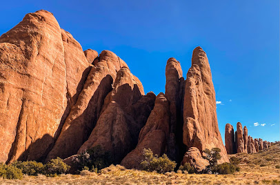
As we drive, exploring more arches, we'll learn more about the Paiute myths behind them, the Spanish and Mormon settlers who tried to survive in this land, and the people who were able to preserve this stunning landscape as a national park.
Devils Gdn Trl & Devils Gdn Trailhead
Our drive through Arches ends at the Devil's Garden, where a final hiking trail leads to Landscape Arch and beyond. Our tour through the mythology and geology of this epic land is now over.
Monitor and Merriamac Rock Formations
Look to the right. All you can see at the moment are tall rock walls. That’s because we’re near the floor of Sevenmile Canyon. As we continue to drive, we’ll emerge from the canyon and be able to see two very distinct features in the distance to the right -- the Merrimac and the Monitor.
Big Mesa Viewpoint
Coming up on your right is Big Mesa Viewpoint. Pause for a quick look at some stunning scenery. The enormous mesa looks like it was plonked down here by accident, and then forgotten.
White Rim Rd
In such a beautiful landscape, you can’t escape the lure of exploring off the beaten path. But watch out! If you do go off the path, you might be trampling on soil that’s alive. You might think I’m joking, but throughout Canyonlands, Arches, and Moab is something called a biological soil crust.
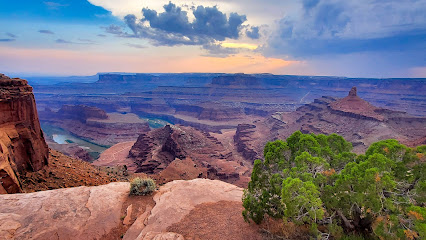
Dead Horse Point — it’s a creepy name, isn’t it? According to local legend, wild mustangs used to be corralled here to be broken in the early 1800s. Once all the desirable horses had been broken and claimed by the cowboys, the undesirables were left to go free.
Island in the Sky
Stop by the Visitor Center coming up ahead. It’s a great place to grab supplies, use the bathroom, and fill up your water bottles. As you’ve already seen, this park doesn’t have much infrastructure, and being dehydrated out here is no joke.
Shafer Canyon Overlook
This overlook offers views from three sides. It may be a bit daunting if you're afraid of heights since there’s nothing between you and the Canyon. However, the incredible view is worth it.
Lathrop Canyon
A lot of natural landmarks and trails in Canyonlands are named by or after cowboys and ranchers. In fact, Ned Chaffin’s father and one of his brothers had a spring named after them.
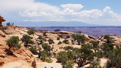
"Ahead, pull over for Mesa Arch. This is a must-do at Canyonlands. Once you’ve parked, walk along the short trail to the arch. As you walk, notice the juniper and pinyon trees around you. These are popular in Canyonlands so keep an eye out for them elsewhere too."
Green River Overlook
The Green River Overlook offers some of the most unique views of Canyonland’s Island in the Sky District. You’re able to see the Green River continuing its work on the canyon walls. The river is the largest stream in Utah at 730 miles. The name probably comes from the green soapstone that can be found along its banks.
Aztec Butte Trail
What makes this trail special? Simple: the granaries left here by Native peoples. They’re visible from the base of the last hill if you just keep your eyes open. These granaries are hundreds of years old, so be careful when approaching.
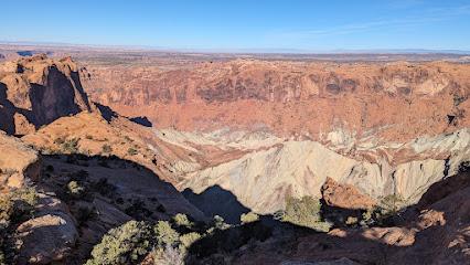
Remember how the park’s rocks have been formed in layers? In most of the park, these layers haven’t been disrupted since their formation. What you see is what was deposited, all those hundreds of millions of years ago.
Candlestick Tower Overlook
In the distance, do you see three giant candles sticking out of the landscape? That’s Candlestick Tower! Doesn’t this sandstone formation look like a layered birthday cake, topped with candles? * The bottom layer is white, the middle a reddish-brown, and the top is red.
Murphy Point Trail
The trail that leads to Murphy Point Overlook is quite easy, adding up to 3.5 miles roundtrip. While the hike itself doesn’t offer much in the way of scenery, the overlook provides a stunning view of Stillwater Canyon and the Green River.
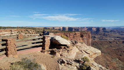
Here you’ll see spectacular views of Buck Canyon and the La Sal mountains. The short trail is paved, making it one of the most accessible places in the park. There’s also a rail that stands between you and the canyon, so if you are scared of heights, this overlook is perfect for you.
White Rim Overlook Trail
This is a great place to rest and enjoy a quick meal! There are only eight tables, so be sure to claim one if there are any available.
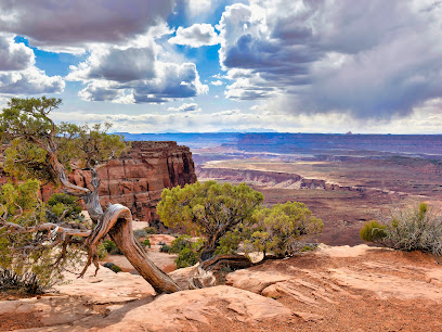
We’re now at the end of the Canyonlands National Park tour. I hope you’ve enjoyed the journey! If you enjoyed the tour, check out our other tours of nearby Arches, Bryce, Zion, and more!
Grand View Point Overlook
We’re now at the end of the Canyonlands National Park tour. I hope you’ve enjoyed the journey! If you enjoyed the tour, check out our other tours of nearby Arches, Bryce, Zion, and more!
Needles District Canyonlands
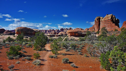
Explore Canyonlands’ Needles District tour, featuring ancient rock art at Newspaper Rock, desert views from Pothole Point, and the iconic Wooden Shoe Overlook.
End Point
Begin from Arches National Park Visitor Center, Moab, UT 84532, USA. After booking the tour, search your emails and texts for "audio tour". Your tour is VALID FOR ONE YEAR so follow these instructions NOW to finish setting up the tour while you have Wi-Fi/data. Do NOT wait until you are onsite.
The experience can be subject to change due to bad weather or unforseen circumstances. We always endeavour to give you the best possible experience.
Additional Information
-
Audio Setup: Connect your phone to your car's stereo system using Bluetooth, USB, or AUX. For the best experience, consider using headphones for walking tours. Audio playback is compatible with Apple CarPlay, with navigation features coming soon. Support for Android Auto is also on the way.
-
Buy once, use for one year! Ideal for extended visits and return trips over the next 12 months.
-
For the best experience, please use an iPhone running iOS 15 or later, an Android device running version 9 or later, or an iPad/tablet with GPS and cellular connectivity, as these are recommended for navigation.
-
Go to the starting point No one will meet you at the start. This tour is self-guided Enter the first story’s point and the audio will begin automatically Follow the audio cues to the next story, which will also play automatically. Enjoy hands-free exploring. If you face audio issues, contact support. Stick to the tour route & speed limit for the best experience.
-
How To Access: After booking, you’ll get an email and text with setup instructions and password (search “audio tour” in emails and texts). • Download the separate tour app by Action • Enter the password sent by email and text. • MUST download the tour while in strong wifi/cellular. • Works offline after download.
-
How to start touring: Open Action’s separate audio tour guide app once onsite. • If there is just one tour, launch it. • If multiple tour versions exist, launch the one with your planned starting point and direction.
-
Public transportation options are available nearby
-
Savings tips: Driving tours: purchase just one tour for everyone in the car
-
Suitable for all physical fitness levels
-
To purchase entrance tickets for Arches & Canyonlands National Parks, please visit their official website
-
Travel worry-free: Use the tour app anytime, on any day, and over multiple days. Start and pause the tour whenever you like, taking breaks and exploring side excursions at your own pace. Skip anything you don’t care about or explore bonus content for everything that interests you
-
⚠️ Important Note: The U.S. Government Shutdown has ended, but some National Park services, visitor centers and facilities may reopen in phases. Please check official park updates before visiting.
What our experts say
-
Download the app before arrival
-
Visit Dead Horse Point for views
-
Pack snacks and water for hikes
-
Check stargazing opportunities at night
-
Explore nearby Moab for dining options
More About this Experience
Introduction
Embark on an unforgettable adventure through the breathtaking beauty of the high desert with the Arches and Canyonlands National Parks Self-Driving Bundle Tour. This tour offers a mesmerizing journey through the iconic Arches and Canyonlands National Parks, where gravity-defying rock formations and sweeping red vistas await. As you explore these classic Western landscapes, you'll be captivated by the stunning natural monuments, unlikely rock formations, and ancient landscapes that surround you. Let the fascinating legends behind each park come to life as you hike through the harsh elegance of these remarkable destinations. Get ready to discover nature in its most unexpected form and create memories that will last a lifetime.What to expect?
During the Arches and Canyonlands National Parks Self-Driving Bundle Tour, you can expect a total duration of 300 to 360 minutes filled with awe-inspiring sights and immersive experiences. Along the journey, you will visit mesmerizing landmarks such as Delicate Arch, the Windows, Panorama Point, and Landscape Arch. You'll also explore the Fiery Furnace, Sand Dune Arch, and the Devil's Garden, each offering a unique perspective of the park's mythology and geology. Prepare for short hikes, breathtaking viewpoints, and the chance to witness the Milky Way in all its splendor. This tour is a comprehensive exploration of the essential highlights of Arches and Canyonlands National Parks.Who is this for?
The Arches and Canyonlands National Parks Self-Driving Bundle Tour is perfect for nature enthusiasts, adventure seekers, and anyone who wants to immerse themselves in the beauty of the high desert. Whether you're a solo traveler, a couple, or a group of friends, this tour is designed to cater to all visitors. From hikers eager to conquer challenging trails to nature lovers who simply want to soak in the stunning scenery, this tour offers something for everyone. No special skills or previous experience are required to enjoy this self-driving adventure. Bring your sense of wonder and an eagerness to explore, and let the magic of Arches and Canyonlands unfold before your eyes.Why book this?
Immerse yourself in the wonder of two of Utah's most remarkable national parks with the Arches and Canyonlands National Parks Self-Driving Bundle Tour. This tour offers a unique opportunity to witness nature's artistry at its finest. Marvel at gravity-defying rock formations, expansive red vistas, and delicate arches that seem to defy the laws of physics. As you drive through these incredible landscapes, a wealth of fascinating stories and legends will be shared, enriching your understanding of the area's geology and cultural history. This self-driving bundle tour allows you to explore at your own pace, ensuring a personalized and immersive experience. With lifetime validity, you have the freedom to plan your visit whenever it suits you. Don't miss the chance to create unforgettable memories in the heart of the high desert.Good to know
When booking the Arches and Canyonlands National Parks Self-Driving Bundle Tour, keep in mind that each purchase covers one tour per vehicle, not per person. Therefore, it's a fantastic option for families, groups, or even solo travelers who prefer the flexibility of driving themselves. Upon booking, you will receive instructions via email to download the Tour Guide App by Action. Through this app, you'll gain access to the tour, audio instructions, and the route. Make sure you have a good internet or Wi-Fi connection to facilitate a seamless experience. It's essential to check the parks' opening hours before your visit to maximize your time. With no expiration date, this tour offers lifetime validity, allowing you to plan your adventure whenever it suits you best.This is a popular product and the date you are looking for just sold out. Next available date is


