Chiricahua Mountains · Travel guide · Updated 2026

The Enchanting Chiricahua Mountains

Explore the Chiricahua Mountains: A Wonderland of Rocks in Arizona's Coronado National Forest, rich in history, diverse wildlife, and stunning natural beauty.

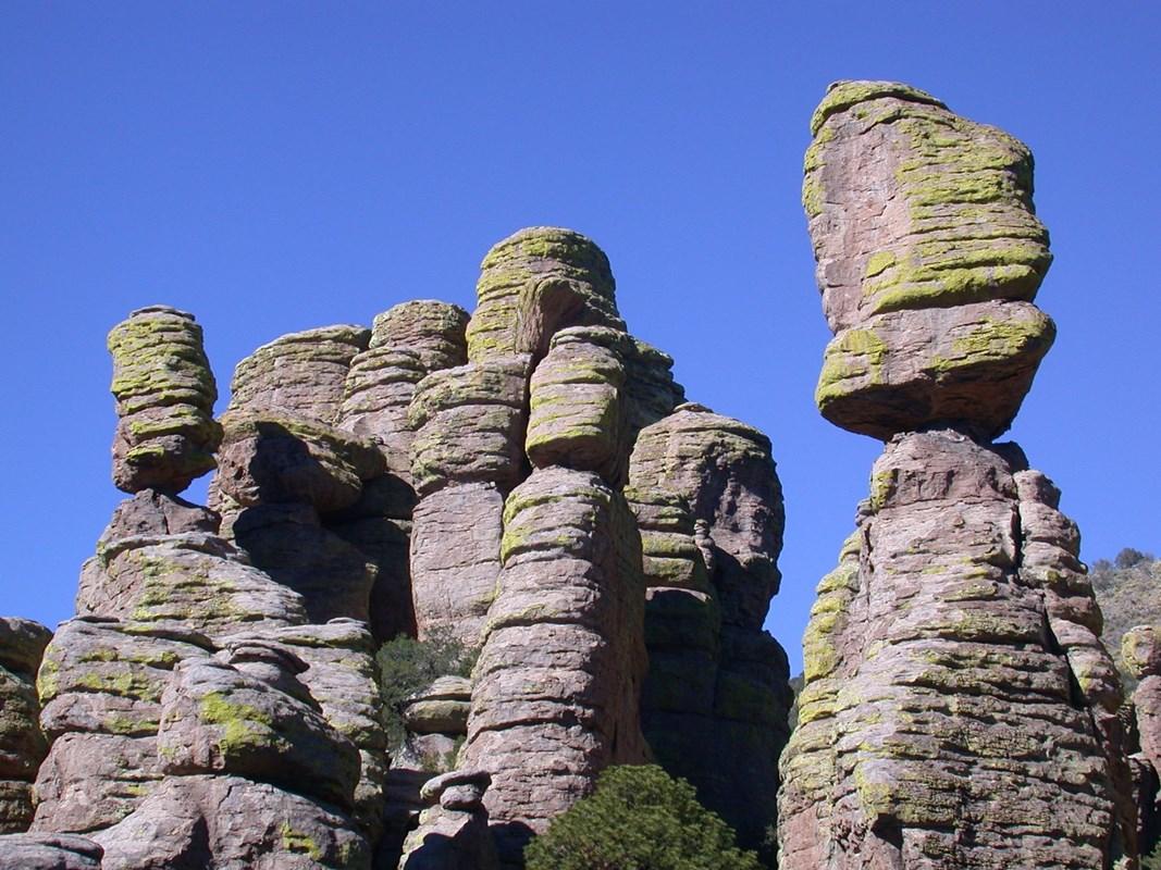
Nestled in the southeastern corner of Arizona, the Chiricahua Mountains offer a magical escape into nature's grandeur. Known as the 'Wonderland of Rocks,' this range is famous for its unique rock formations that seem to reach for the sky. The mountains are part of the larger Coronado National Forest, making it a perfect spot for hiking, bird-watching, and exploring the rich biodiversity of the area. The Chiricahua Mountains are steeped in history and culture. Once home to the Chiricahua Apache tribe, the area holds many stories and legends that add to its mystique. Fort Bowie National Historic Site nearby offers a glimpse into the turbulent times of the Apache Wars, providing a historical context to your adventure. The landscape here is a blend of rugged beauty and serene vistas, ideal for photography and nature walks. For those interested in wildlife, the Chiricahua Mountains are a treasure trove. The diverse ecosystem supports a variety of species, from black bears and mountain lions to an array of bird species that attract birdwatchers from around the globe. The region's unique climate and elevation changes create different habitats, making every hike a new discovery. The Chiricahua National Monument, located within the mountain range, is a must-visit. The park offers well-maintained trails that guide you through some of the most breathtaking scenery in Arizona. Whether you're an avid hiker or a casual nature lover, the Chiricahua Mountains provide an unforgettable experience filled with natural beauty and tranquility.

When is the best time to go to Chiricahua Mountains?

Weather at a glance

Use the monthly temperature and precipitation trends to compare typical conditions across the year before planning countryside walks, town visits, and heritage days.

Temperature

°C

Precipitation

mm
Warmest monthsJul–Aug
Longest daylightMay–Jul
Driest periodMay

Explore places in Chiricahua Mountains

    See all →
    File:Grand Canyon landscape.jpg - Wikimedia Commons
    Destination guide

    More about Arizona

    Discover Arizona: From the majestic Grand Canyon and red rocks of Sedona to the vibrant cities of Phoenix and Scottsdale, explore the diverse beauty and culture of the Grand Canyon State.

    Tell me more about Arizona
    Mobile App
    Get the app

    Your all‑in‑one travel companion app

    Explore expert travel guides, compare and book tours, experiences, hotels, and more—all from the palm of your hand. Download now for seamless trip planning wherever your wanderlust takes you.

    Explore Chiricahua Mountains in Photos

    A quick visual route through countryside views, towns, gardens, and regional day-trip atmosphere.

    File:Chiricahua balanced rock.jpg - Wikipedia
    File:Head of Chief Cochise, Chiricahua National Monument.jpg - Wikimedia  Commons
    100 Years of Trails - Guided Hike
    File:Massai Point, Chiricahua National Monument, Arizona.jpg - Wikimedia  Commons
    National Park Getaway: Chiricahua National Monument (U.S. National Park  Service)
    File:Faraway Ranch House Arizona 2014.JPG - Wikimedia Commons
    File:Chiricahua balanced rock.jpg - Wikipedia
    File:Mule Deer Sulphur Springs Valley Arizona 2014.jpg - Wikimedia Commons

    Planning another trip?

    Continue exploring nearby country regions around Chiricahua Mountains, from connected city edges to neighbouring counties, coastlines, and countryside escapes.

    Select Currency

    Choose the currency you want prices to display in.