

Death Valley National Park Travel Guide - Free Web & App
Your ultimate guide to Death Valley National Park. Discover top landmarks, proposed trips, and local tips. Free on the web or via the Evendo companion app.


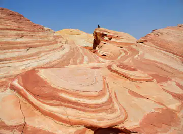
Death Valley National Park in California pairs salt flats, desert mountains, dunes, canyons and dark skies with mining history and remarkable desert wildlife.
A Vast Basin of Contrasts
Death Valley National Park occupies more than 3.4 million acres in eastern California, close to the Nevada border, and is one of the largest national parks in the contiguous United States. Its name suggests a single harsh landscape, but the park is a complex sequence of salt flats, alluvial fans, volcanic craters, sandstone canyons, sand dunes and high mountain ranges. Badwater Basin lies 282 feet below sea level, while Telescope Peak rises above 11,000 feet in the Panamint Range, creating an exceptional vertical range within a relatively compact desert region.Read more about Death Valley National Park
Landscapes and Wildlife
Exploring the Park
When is the best time to visit Death Valley National Park?
Best: February–March, November · 23–27°C| Month | High (°C) | Rainfall (mm) |
|---|---|---|
| January | 20 | 6 |
| February (best) | 23 | 5 |
| March (best) | 27 | 5 |
| April | 33 | 2 |
| May | 38 | 2 |
| June | 44 | 1 |
| July | 47 | 4 |
| August | 46 | 6 |
| September | 42 | 3 |
| October | 35 | 3 |
| November (best) | 26 | 5 |
| December | 19 | 6 |
Getting to and around Death Valley National Park
How to get there
Transportation
Best attractions in Death Valley National Park
Death Valley's principal attractions are spread across a huge and varied desert landscape. Badwater Basin presents a broad salt floor beneath the surrounding mountains, while the nearby Natural Bridge and Golden Canyon offer more intimate geological scenery on established routes. Artist's Drive is known for vividly coloured mineral slopes, and Zabriskie Point provides a celebrated view across eroded badlands at sunrise or sunset. Mesquite Flat Sand Dunes rise near Stovepipe Wells, although the apparent closeness of the dunes can conceal strenuous walking on soft sand. In the northern park, Ubehebe Crater records explosive volcanic activity, while Racetrack Playa is noted for its remote playa surface and moving rocks; reaching it requires careful planning and suitable conditions. Salt Creek offers a chance to observe specialised desert aquatic life, and Dante's View looks down across the basin from the Black Mountains. The park's historic borax works and ranching sites add cultural context to the natural attractions.
-
Visitor center
Furnace Creek Visitor Center
Explore the enchanting landscapes of Death Valley at Furnace Creek Visitor Center, your ultimate guide to this unique desert oasis.
-
Mountain peak
Dante’s View
Experience unparalleled panoramic views at Dante's View in Death Valley National Park, a scenic spot that captures the essence of desert beauty.
-
Mesquite Flat Sand Dunes
Discover the breathtaking Mesquite Flat Sand Dunes in Death Valley, where stunning landscapes and adventure await every visitor.
-
Tourist attraction
Father Crowley Overlook
Experience the breathtaking vistas and serene beauty at Father Crowley Overlook in Death Valley National Park, a must-visit scenic spot for every traveler.


Best landmarks in Death Valley National Park
Badwater Basin is Death Valley's defining natural landmark, a vast salt-covered depression at 282 feet below sea level and the lowest point in North America. Above it, the Black, Funeral, Panamint and Amargosa ranges create the dramatic enclosed geography that shapes the park's identity. Telescope Peak, the highest summit in the park, demonstrates the sharp contrast between the valley floor and high desert mountains. Zabriskie Point and Artist's Palette are recognised for their eroded and mineral-coloured formations, while Ubehebe Crater is a prominent volcanic landmark in the north. Harmony Borax Works represents the industrial history of the valley, with surviving structures and machinery associated with nineteenth-century borax processing. Mesquite Flat Sand Dunes, though constantly reshaped by wind, provide another visually distinctive landmark, while the Devil's Hole pupfish habitat reflects the specialised ecological history of the wider Death Valley region.
-
Visitor center
Furnace Creek Visitor Center
Discover the Furnace Creek Visitor Center in Death Valley, your essential guide to the wonders of this spectacular desert landscape.
-
Scenic spot
Dante’s View
Experience the breathtaking beauty of Death Valley from Dante's View, a stunning overlook that captures the vastness of the desert landscape.
-
Scenic spot
Mesquite Flat Sand Dunes
Explore the stunning Mesquite Flat Sand Dunes in Death Valley National Park, where golden sands and breathtaking views await every adventurer.
-
Resort hotel
The Ranch at Death Valley
Discover the ultimate desert retreat at The Ranch at Death Valley, where comfort meets the breathtaking beauty of one of America's most iconic national parks.


Explore Death Valley National Park on the map
Plan your trip on one map. See where the top attractions, landmarks, restaurants and hotels are, and book hotels and experiences in a few clicks.
Best hotels in Death Valley National Park
Best restaurants in Death Valley National Park
Dining within Death Valley National Park is concentrated in the developed areas rather than distributed throughout the landscape. Furnace Creek has the widest range of established food services, including hotel-based dining and more informal options, while Stovepipe Wells and Panamint Springs provide additional meals for travellers crossing the park. Menus are generally shaped by practical desert logistics and American western hospitality rather than a distinctive local cuisine, so visitors undertaking long drives should carry suitable provisions and avoid assuming that food will be available at every stop. Nearby gateway towns such as Beatty, Pahrump, Lone Pine and Ridgecrest offer broader choices before or after a park visit. Water and food planning are particularly important for remote routes, where there may be no café, shop or reliable service between developed settlements.
-
Steak
Last Kind Words Saloon
Experience mouthwatering steaks and rustic charm at Last Kind Words Saloon in Death Valley National Park.
-
Steak
Steaks and Beer
Discover mouthwatering steaks and refreshing beers at Steaks and Beer in Tecopa—a hidden gem perfect for meat lovers visiting California's serene desert.
-
Restaurant
Toll Road Restaurant
Discover culinary delights at Toll Road Restaurant, where delicious food meets stunning views in Death Valley National Park.
-
Bar
Badwater Saloon
Discover Badwater Saloon in Death Valley - your perfect stop for refreshing drinks and relaxation amidst stunning desert landscapes.


Best bars in Death Valley National Park
Death Valley has no conventional nightlife district and very little reason to expect nightclubs or late-night entertainment. Evening life is centred on the accommodation areas at Furnace Creek, Stovepipe Wells and Panamint Springs, where visitors may find hotel bars, lounges or informal hospitality depending on the operating arrangements of individual properties. The atmosphere is generally quiet and oriented towards conversation, meals and rest after time outdoors. Outside the developed centres, the park's main evening attraction is the desert itself: clear, dark conditions can reveal an exceptionally rich night sky, although visitors should use lights discreetly and remain aware of uneven ground, road traffic and changing temperatures. Nearby towns such as Beatty and Pahrump provide more conventional bars, but they lie outside the national park.
-
American
Crowbar Cafe & Saloon
Discover the heart of Shoshone at Crowbar Cafe & Saloon, where American flavors meet rustic charm in a welcoming atmosphere.
-
Bar
Stovepipe Wells Village Hotel
Discover the heart of Death Valley at Stovepipe Wells Village Hotel, where adventure meets comfort amidst stunning desert landscapes.
-
Grill
The Hubb
Experience the vibrant flavors and welcoming atmosphere at The Hubb, Pahrump's favorite grill and bar, where every meal is a celebration.
-
Bar
Wild Side Tavern(WST)
Discover the excitement of Wild Side Tavern in Pahrump, NV - a premier bar for gambling, nightlife, and unforgettable experiences.


Best nightclubs in Death Valley National Park
Death Valley has no conventional nightlife district and very little reason to expect nightclubs or late-night entertainment. Evening life is centred on the accommodation areas at Furnace Creek, Stovepipe Wells and Panamint Springs, where visitors may find hotel bars, lounges or informal hospitality depending on the operating arrangements of individual properties. The atmosphere is generally quiet and oriented towards conversation, meals and rest after time outdoors. Outside the developed centres, the park's main evening attraction is the desert itself: clear, dark conditions can reveal an exceptionally rich night sky, although visitors should use lights discreetly and remain aware of uneven ground, road traffic and changing temperatures. Nearby towns such as Beatty and Pahrump provide more conventional bars, but they lie outside the national park.
-
Hotel
Stovepipe Wells Village Hotel
Experience the stunning landscapes of Death Valley from the comfort of Stovepipe Wells Village Hotel, a unique desert retreat.
-
 Hotel
Amargosa Opera House
Experience the unique blend of history and performance art at the Amargosa Opera House, a cultural icon in the heart of Death Valley.
-
Steak
Last Kind Words Saloon
Discover the unique charm of Last Kind Words Saloon, a rustic steakhouse located in the heart of Death Valley National Park, perfect for tourists seeking hearty meals.
-
Bar
Badwater Saloon
Discover Badwater Saloon, a cozy bar in Death Valley National Park offering breathtaking views and delicious bites amidst stunning desert landscapes.


Best shops in Death Valley National Park
Shopping inside Death Valley National Park is limited and concentrated at developed visitor and accommodation areas, where small shops or general stores may stock drinks, snacks, basic supplies, books and souvenirs. Furnace Creek is usually the most substantial place to look for park-related publications, maps and gifts, while facilities at Stovepipe Wells and Panamint Springs are more modest. There is no extensive retail district within the park, so outdoor equipment, fuel-related supplies and specialist provisions are better sourced in gateway towns such as Las Vegas, Pahrump, Beatty, Lone Pine or Ridgecrest. Visitors may find books about desert geology, the Timbisha Shoshone, mining and national-park history more meaningful than generic merchandise. Food and drink purchases should be planned around actual settlements, as remote viewpoints and trailheads have no shopping facilities.
-
Vista point
Zabriskie Point
Discover Zabriskie Point: A Stunning Vista Point in Death Valley National Park, Perfect for Sunrise, Sunset, and Hiking Adventures.
-
Visitor center
Furnace Creek Visitor Center
Explore Death Valley National Park from the Furnace Creek Visitor Center, your essential stop for information, exhibits, and breathtaking views.
-
Hotel
The Inn at Death Valley
Experience unparalleled luxury and natural beauty at The Inn at Death Valley, your oasis in the heart of California's stunning desert landscape.
-
Resort hotel
The Ranch at Death Valley
Discover The Ranch at Death Valley, a restful haven amidst stunning desert landscapes, perfect for adventurers and nature lovers.


Get your free copy of our complete guide to Death Valley National Park, delivered straight to you.
Everything on this page, from attractions and restaurants to essentials and local phrases, in one PDF you can read offline, print or share.
Already have an account? Sign in
Your Death Valley National Park guide is ready.
We'll send it to · Not you? Sign out

Getting your guide ready…
We are putting together a fresh copy of the Death Valley National Park guide. This can take up to a minute.
This can take a few moments. If your browser asks, choose Allow so the download can start. You'll find the guide in your Downloads folder.
Nothing happened? Download it again
Sorry, the guide is taking longer than usual. Please try again in a minute, or get it by email instead.
Death Valley National Park essentials
Currency and Payment
Safety
Emergency Situations
Do's and Don'ts
Local Tips
From Eve
Local phrases worth knowing
You don't need to get them perfect. A few words go a long way, and locals appreciate the effort.
Basics
| English | Local | Say it |
|---|---|---|
| Hello | Howdy | [haʊ-di] |
| Goodbye | See ya later | [siː jə ˈleɪ.tər] |
| Yes | Yup | [yʌp] |
| No | Nah | [nɑː] |
| Please/You're welcome | Please and thank ya | [pliːz ænd θæŋk jə] |
| Thank you | Much obliged | [mʌtʃ əˈblaɪdʒd] |
| Excuse me/Sorry | Pardon me | [ˈpɑrdn mi] |
| How are you? | Howdy partner? | [haʊ-di ˈpɑːrtn̩r] |
| Fine. And you? | I'm doin' just fine. How 'bout you? | [aɪm ˈdɔɪn dʒʌst faɪn haʊ ˈbaʊt jʊ] |
| Do you speak English? | Y'all speak English? | [jɔːl spiːk ˈɪŋɡlɪʃ] |
| I don't understand | I reckon I'm lost | [aɪ ˈrɛkən aɪm lɒst] |
Eating & Drinking
| English | Local | Say it |
|---|---|---|
| I'd like to see the menu, please | Could I take a gander at the menu? | [kʊd aɪ teɪk ə ˈɡændər æt ðə ˈmɛnjuː] |
| I don't eat meat | I ain't no meat eater | [aɪ eɪnt nəʊ miːt ˈiːtər] |
| Cheers! | Bottoms up! | [ˈbɒtəmz ʌp] |
| I would like to pay, please | I reckon it's time to settle the bill | [aɪ ˈrɛkən ɪts taɪm tuː ˈsɛtəl ðə bɪl] |
Emergencies
| English | Local | Say it |
|---|---|---|
| Help! | I need a hand! | [aɪ niːd ə hænd] |
| Go away! | Skedaddle! | [skɪˈdædəl] |
| Call the Police! | Round up the Sheriff! | [raʊnd ʌp ðə ˈʃɛrɪf] |
| Call a doctor! | Send for the Doc! | [sɛnd fɔːr ðə dɒk] |
| I'm lost | I'm turned around | [aɪm tɜːnd əˈraʊnd] |
| I'm ill | I'm feelin' poorly | [aɪm ˈfiːlɪn ˈpʊrli] |
Shopping
| English | Local | Say it |
|---|---|---|
| I'd like to buy... | I'm fixin' to purchase... | [aɪm ˈfɪksɪn tuː ˈpɜːrtʃəs] |
| I'm just looking | I'm just browsin' | [aɪm dʒʌst ˈbraʊzɪn] |
| How much is it? | What's the damage? | [wɒts ðə ˈdæmɪdʒ] |
| That's too expensive | That's a mite pricey | [ðæts ə maɪt ˈpraɪsi] |
| Can you lower the price? | Kin ya wiggle on the cost? | [kɪn jə ˈwɪɡəl ɒn ðə kɒst] |
Time & Numbers
| English | Local | Say it |
|---|---|---|
| What time is it? | What's the hour? | [wɒts ðə ˈaʊər] |
| It's one o'clock | It's high noon | [ɪts haɪ nuːn] |
| Half past (10) | Half past (10) | [hɑːf pæst (10)] |
| Morning | Mornin' | [ˈmɔːrnɪn] |
| Afternoon | Afternoon | [ˌæftəˈnuːn] |
| Evening | Evenin' | [ˈiːvənɪn] |
| Yesterday | Yest'day | [ˈjɛstˌdeɪ] |
| Today | Today | [təˈdeɪ] |
| Tomorrow | Tomorrow | [təˈmɒrəʊ] |
| 1 | One | [wʌn] |
| 2 | Two | [tuː] |
| 3 | Three | [θriː] |
| 4 | Four | [fɔːr] |
| 5 | Five | [faɪv] |
| 6 | Six | [sɪks] |
| 7 | Seven | [ˈsɛvən] |
| 8 | Eight | [eɪt] |
| 9 | Nine | [naɪn] |
| 10 | Ten | [tɛn] |
Transport & Directions
| English | Local | Say it |
|---|---|---|
| Where's a/the...? | Where's that...? | [wɛəz ðæt] |
| What's the address? | What's the street? | [wɒts ðə striːt] |
| Can you show me (on the map)? | Kin ya point it out (on the map)? | [kɪn jə pɔɪnt ɪt aʊt ɒn ðə mæp] |
| When's the next (bus)? | When's the next ride? | [wɛnz ðə nɛkst raɪd] |
| A ticket (to ....) | A pass (to ....) | [ə pæs tuː] |
History of Death Valley National Park
A Basin Shaped by Faulting
Death Valley is part of the Basin and Range Province, a region where faulting has produced alternating mountain ranges and deep valleys. The valley floor has repeatedly accumulated sediment and evaporated-water deposits, leaving the extensive salt crust associated with Badwater Basin. This geological setting continues to influence the park's identity: steep ranges rise abruptly from broad alluvial fans, while volcanic activity has contributed features such as Ubehebe Crater. Geological processes rather than a single historical event explain the dramatic differences in elevation, rock colour and surface texture found across the park.
The Timbisha Shoshone Homeland
The Timbisha Shoshone have longstanding cultural and geographical ties to Death Valley and the surrounding desert ranges. Their knowledge of springs, plants, animals and seasonal movement reflects a detailed relationship with an environment often misrepresented as empty or incapable of supporting human life. European-American naming and mapping later imposed labels such as Death Valley, but Indigenous presence predates those accounts by many centuries. The Timbisha Shoshone Tribe remains based in the region, and its connection to the landscape is an essential part of understanding the park's history.
Mining and the Borax Era
Mining brought the most visible nineteenth-century industrial change to Death Valley. Borax extraction became particularly important during the late 1800s, and the Twenty Mule Team image grew from the long wagon journeys used to transport refined borax from the valley. Gold, silver, lead and other minerals also attracted prospectors, leaving mine workings, roads and scattered ruins in parts of the park. The mining boom was difficult and short-lived in many locations, but its traces remain central to the cultural landscape, especially around Harmony Borax Works near Furnace Creek.
Protection and Early Tourism
Death Valley National Monument was established in 1933, bringing federal protection to a large desert landscape while allowing some existing uses to continue. Roads, automobiles and accommodation gradually made the valley more accessible to visitors, and Furnace Creek developed as an important centre for park travel. Tourism changed how the area was perceived, shifting attention from mineral extraction towards scenery, climate and recreation. Historic structures associated with mining, ranching and early park development now form part of the broader heritage visitors encounter alongside the natural landscape.
From National Monument to National Park
Congress redesignated Death Valley National Monument as Death Valley National Park in 1994 through the California Desert Protection Act. The change expanded the park and strengthened recognition of its ecological, geological and cultural importance. Modern management balances visitor access with protection of fragile desert soils, archaeological resources, wildlife habitat and historic remains. The park's history is therefore not simply a record of extraction and settlement; it also reflects changing national attitudes towards desert conservation, Indigenous rights, wilderness and the value of landscapes once regarded mainly as obstacles to travel.
Death Valley National Park in Photos
Browse through our photo collection highlighting the charm and character of the destination.
Cities in Death Valley National Park
The towns and cities of Death Valley National Park, and the easiest places to base yourself.

Swipe for more cities
Neighbouring destination travel guides
The closest destinations to Death Valley National Park, if you have time for more than one.
-

-

-

-

-


Swipe for more destinations
Explore more

Explore more of Southern California
Explore Southern California for Pacific beaches, Los Angeles culture, San Diego heritage, desert landscapes, mountains and globally diverse food.
Explore Southern California
Explore more of California
Discover California: A land of diverse landscapes, iconic cities, and endless adventures, from sun-soaked beaches to towering redwoods and vibrant cultural experiences.
Explore California