

Vercors Regional Natural Park Travel Guide - Free Web & App
Your ultimate guide to Vercors Regional Natural Park. Discover top landmarks, proposed trips, and local tips. Free on the web or via the Evendo companion app.


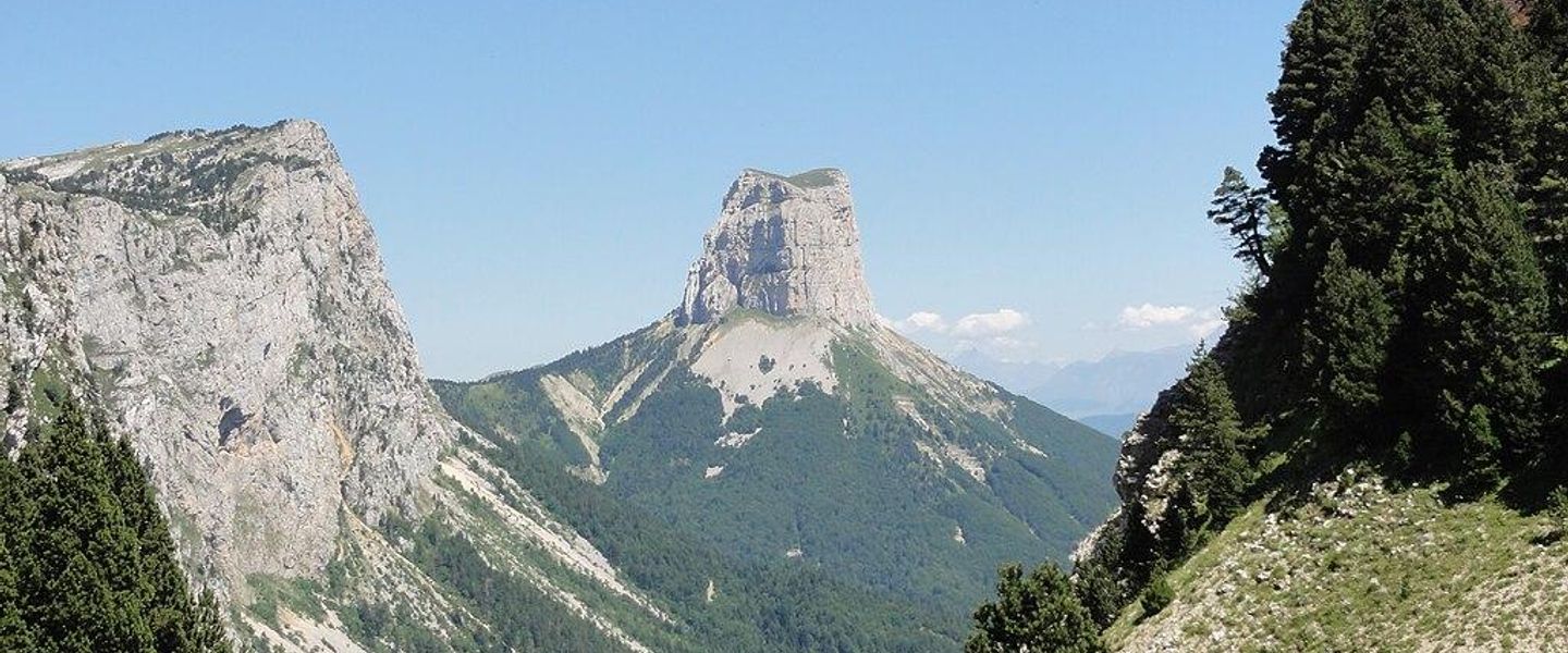


Vercors Regional Natural Park in France combines limestone peaks, deep gorges, alpine villages, Resistance history, caves, hiking, climbing and wildlife.
A Mountain Plateau Above the Rhône Valley
Vercors Regional Natural Park occupies a broad limestone massif between Grenoble, Valence and Die in south-eastern France. Its high plateaux, forested ridges, deep gorges and sheer escarpments create a landscape that feels both alpine and distinctly pre-Alpine. The massif rises in a series of wooded and open uplands, culminating in the Grand Veymont at 2,341 metres, while the Mont Aiguille stands apart as one of the region’s most recognisable rock formations. Roads approach through dramatic corridors such as the Gorges de la Bourne and the Combe Laval, although the park’s interior is best understood through walking paths, mountain roads and quiet villages rather than a single central hub.Read more about Vercors Regional Natural Park
Karst Landscapes and Outdoor Life
Memory, Villages and Regional Flavours
When is the best time to visit Vercors Regional Natural Park?
Best: May–June, September · 22–26°C| Month | High (°C) | Rainfall (mm) |
|---|---|---|
| January | 5 | 53 |
| February | 6 | 48 |
| March | 10 | 54 |
| April | 16 | 57 |
| May (best) | 22 | 73 |
| June (best) | 26 | 82 |
| July | 30 | 88 |
| August | 29 | 85 |
| September (best) | 23 | 74 |
| October | 16 | 69 |
| November | 10 | 59 |
| December | 6 | 52 |
Getting to and around Vercors Regional Natural Park
How to get there
Transportation
Best attractions in Vercors Regional Natural Park
The Vercors offers a wide range of landscapes across a large mountain massif. The Hauts-Plateaux du Vercors Nature Reserve provides the most remote walking environment, with forests, open limestone uplands and the ascent of the Grand Veymont, the park’s highest summit. The Mont Aiguille, viewed from surrounding valleys and passes, is an iconic isolated peak, while the Cirque d’Archiane presents a dramatic southern amphitheatre of cliffs. The Gorges de la Bourne and Combe Laval are memorable engineered road corridors through precipitous terrain, and the caves at Choranche reveal the massif’s subterranean geology through organised visits. Around Vassieux-en-Vercors, the Mémorial de la Résistance and Musée de la Préhistoire connect landscape with human history. Villard-de-Lans, Autrans-Méaudre and the villages of the central plateau provide bases for walking, cycling, climbing, cross-country skiing and visits to farms and local museums.
-
Tourist attraction
Fontaines Pétrifiantes Garden
Explore the magical Fontaines Pétrifiantes Garden, a stunning botanical garden in the Vercors region with unique petrifying springs and diverse plant life.
-
Bridge
Passerelle Himalayenne du Drac
Experience breathtaking views from the Himalayan-style Passerelle du Drac, a thrilling bridge spanning the stunning Lac de Monteynard.
-
Tourist attraction
Passerelle himalayenne de l'Ébron
Experience breathtaking views from this suspended Himalayan bridge in the French Alps, offering a thrilling walk above the Ébron River and Lake Monteynard.
-
Tourist attraction
Pont en Royans's Water Museum
Explore the wonders of water in a fun, interactive museum in the heart of the charming village of Pont-en-Royans.


Best landmarks in Vercors Regional Natural Park
The Vercors’ defining landmarks are predominantly geological and environmental. The Mont Aiguille rises as a detached limestone monolith on the eastern side of the massif, while the Grand Veymont forms the highest point of the park and a major highland reference. The cliffs of the Cirque d’Archiane, the Presles escarpment and the Font d’Urle plateau reveal the scale and variety of the limestone architecture. The Gorges de la Bourne and Combe Laval are landmarks of both natural erosion and ambitious mountain-road engineering. Beneath the surface, the Grotte de Choranche illustrates the park’s karst system and underground waterways. Human landmarks include the Mémorial de la Résistance at the Col de la Chau, the memorial landscape around Vassieux-en-Vercors and the Musée de la Préhistoire du Vercors, which together connect the massif’s difficult terrain with prehistoric occupation, rural life and wartime history.
-
Nature preserve
Parc naturel régional du Vercors
Discover the stunning Vercors Regional Natural Park in the French Alps, a paradise for nature lovers and adventure enthusiasts alike.

Explore Vercors Regional Natural Park on the map
Plan your trip on one map. See where the top attractions, landmarks, restaurants and hotels are, and book hotels and experiences in a few clicks.
Best hotels in Vercors Regional Natural Park
Best restaurants in Vercors Regional Natural Park
Dining in and around the Vercors reflects mountain farming, the dairy tradition and the produce of the surrounding Drôme and Isère valleys. Village restaurants, auberges, cafés and traditional inns are concentrated in settlements such as Villard-de-Lans, Lans-en-Vercors, Pont-en-Royans, La Chapelle-en-Vercors, Vassieux-en-Vercors and Die, while remote trail areas have few or no food services. Look for Bleu du Vercors-Sassenage, a local blue cheese made from cow’s milk, alongside regional cheeses, walnuts, seasonal mountain produce and the Dauphiné speciality ravioles. The southern approaches connect with the vineyards of the Diois and Clairette de Die, while markets and farm shops provide opportunities to buy bread, cheese, charcuterie and other provisions for self-catering. Menus and opening patterns vary by season, so supplies should be arranged before setting out into the high plateaux.
-
French
Le Clariant
Experience authentic French cuisine at Le Clariant in Corrençon-en-Vercors - where every dish tells a story amidst stunning alpine views.
-
Restaurant
Les Hauts Plateaux
Discover Les Hauts Plateaux: A charming French restaurant offering exquisite cuisine amid the stunning landscapes of Corrençon-en-Vercors.
-
French
Côté Terrasse VERCORS
Experience authentic French cuisine at Côté Terrasse VERCORS while enjoying breathtaking mountain views in La Chapelle-en-Vercors.
-
Restaurant
Auberge des Allières
Experience authentic French cuisine and cozy mountain lodging at Auberge des Allières in Lans-en-Vercors.


Best bars in Vercors Regional Natural Park
The Vercors is not a nightlife destination, and evening entertainment is generally centred on village cafés, hotel bars, traditional auberges and occasional cultural events rather than clubs or late-night venues. Villard-de-Lans has the broadest concentration of hospitality businesses within the park, while Lans-en-Vercors, Autrans-Méaudre, Die and other gateway settlements offer quieter places for an evening drink or meal. In rural villages, the atmosphere is local and unhurried, with activity often linked to the day’s outdoor pursuits and the seasonal rhythm of skiing, festivals or community events. Visitors staying near Vassieux-en-Vercors, the central plateau or the Hauts-Plateaux should expect limited late-evening services and plan food, transport and drinks around their accommodation. Larger urban nightlife is found outside the park in Grenoble, Valence or Romans-sur-Isère rather than within the protected landscape.
-
Nature preserve
Parc naturel régional du Vercors
Experience breathtaking landscapes and diverse wildlife at Parc naturel régional du Vercors, a true gem in the French Alps.
-
French
Le Clariant
Experience the authentic taste of France at Le Clariant, where culinary artistry meets the stunning landscapes of Corrençon-en-Vercors.
-
Restaurant
Les Hauts Plateaux
Experience exquisite French cuisine amidst the stunning scenery of the French Alps at Les Hauts Plateaux in Corrençon-en-Vercors.
-
Restaurant
Auberge des Allières
Discover the serene charm of Auberge des Allières, where delightful cuisine meets stunning mountain scenery in Lans-en-Vercors.


Best nightclubs in Vercors Regional Natural Park
The Vercors is not a nightlife destination, and evening entertainment is generally centred on village cafés, hotel bars, traditional auberges and occasional cultural events rather than clubs or late-night venues. Villard-de-Lans has the broadest concentration of hospitality businesses within the park, while Lans-en-Vercors, Autrans-Méaudre, Die and other gateway settlements offer quieter places for an evening drink or meal. In rural villages, the atmosphere is local and unhurried, with activity often linked to the day’s outdoor pursuits and the seasonal rhythm of skiing, festivals or community events. Visitors staying near Vassieux-en-Vercors, the central plateau or the Hauts-Plateaux should expect limited late-evening services and plan food, transport and drinks around their accommodation. Larger urban nightlife is found outside the park in Grenoble, Valence or Romans-sur-Isère rather than within the protected landscape.
-
Nature preserve
Parc naturel régional du Vercors
Explore the breathtaking landscapes and rich biodiversity of Parc naturel régional du Vercors, a premier destination for nature lovers and outdoor adventurers.
-
Mountain range
Vercors Massif
Experience the Vercors Massif: A stunning mountain range in the French Alps, perfect for adventure, relaxation, and breathtaking natural beauty.
-
Disco club
L'Avalanche Club
Experience the vibrant nightlife at L'Avalanche Club, Les Deux Alpes' premier disco destination for unforgettable nights of dancing and fun.
-
Disco club
LE 1800 NIGHTCLUB
Experience the electrifying atmosphere of LE 1800 Nightclub in Les Deux Alpes, where unforgettable nights and vibrant music await every visitor.



Best shops in Vercors Regional Natural Park
Shopping in the Vercors is small-scale and closely linked to local food, farming and outdoor life rather than conventional retail. Village shops, weekly markets, farm outlets and producers around Villard-de-Lans, Autrans-Méaudre, La Chapelle-en-Vercors, Vassieux-en-Vercors and Die are useful places to look for Bleu du Vercors-Sassenage, walnuts, honey, preserves, bread, charcuterie and other regional provisions. The southern gateway of Die also reflects the wider Diois wine culture, including Clairette de Die. Visitors may find locally made textiles, woodwork, pottery, artwork and crafts through individual makers or seasonal markets, although availability varies and there is no single shopping district serving the whole park. Outdoor equipment and ski-related retail is concentrated in the larger resort settlements. In remote areas, buy food, fuel and practical supplies before heading towards the high plateaux, where permanent shops are scarce.
-
Nature preserve
Parc naturel régional du Vercors
Explore the stunning landscapes and rich biodiversity of Parc naturel régional du Vercors, a premier nature preserve in the French Alps.
-
Tourist attraction
Caves of La Luire - Guided tours
Explore the breathtaking Caves of La Luire, a stunning natural wonder with guided tours, rich history, and captivating geological formations.
-
Sporting goods store
Altiplano
Discover Altiplano in Villard-de-Lans - your one-stop shop for biking, skiing, and mountain gear in the heart of the French Alps.
-
Cheese shop
La Chèvrerie des Cabrioles, Corrençon en Vercors
Discover the rich flavors of artisanal cheese at La Chèvrerie des Cabrioles, a charming farm and cheese shop in the heart of the Vercors.


Get your free copy of our complete guide to Vercors Regional Natural Park, delivered straight to you.
Everything on this page, from attractions and restaurants to essentials and local phrases, in one PDF you can read offline, print or share.
Already have an account? Sign in
Your Vercors Regional Natural Park guide is ready.
We'll send it to · Not you? Sign out

Getting your guide ready…
We are putting together a fresh copy of the Vercors Regional Natural Park guide. This can take up to a minute.
This can take a few moments. If your browser asks, choose Allow so the download can start. You'll find the guide in your Downloads folder.
Nothing happened? Download it again
Sorry, the guide is taking longer than usual. Please try again in a minute, or get it by email instead.
Vercors Regional Natural Park essentials
Currency and Payment
Safety
Emergency Situations
Do's and Don'ts
Local Tips
From Eve
Local phrases worth knowing
You don't need to get them perfect. A few words go a long way, and locals appreciate the effort.
Basics
| English | Local | Say it |
|---|---|---|
| Hello | Bonjour | [bohn-zhoor] |
| Goodbye | Au revoir | [oh ruh-vwahr] |
| Yes | Oui | [wee] |
| No | Non | [nohn] |
| Please/You're welcome | S'il vous plaît / De rien | [seel voo pleh / duh ryehn] |
| Thank you | Merci | [mehr-see] |
| Excuse me/Sorry | Excusez-moi / Désolé | [ehk-skew-zay mwah / day-zoh-lay] |
| How are you? | Comment ça va? | [koh-mohn sah vah] |
| Fine. And you? | Bien. Et vous? | [byen. ay voo] |
| Do you speak English? | Parlez-vous anglais? | [par-lay voo ahn-glay] |
| I don't understand | Je ne comprends pas | [zhuh nuh kohm-prahnd pah] |
Eating & Drinking
| English | Local | Say it |
|---|---|---|
| I'd like to see the menu, please | Je voudrais voir la carte, s'il vous plaît | [zhuh voo-dray vwar lah kart, seel voo pleh] |
| I don't eat meat | Je ne mange pas de viande | [zhuh nuh mahnzh pah duh vee-ahnd] |
| Cheers! | Santé! | [sahn-tay] |
| I would like to pay, please | Je voudrais payer, s'il vous plaît | [zhuh voo-dray pay-ay, seel voo pleh] |
Emergencies
| English | Local | Say it |
|---|---|---|
| Help! | Au secours! | [oh sey-coor] |
| Go away! | Allez-vous en! | [ah-lay vooz ahn] |
| Call the Police! | Appelez la police! | [ah-peh-lay lah poh-lees] |
| Call a doctor! | Appelez un médecin! | [ah-peh-lay uh may-deh-sahn] |
| I'm lost | Je suis perdu | [zhuh swee pehr-doo] |
| I'm ill | Je suis malade | [zhuh swee mah-lahd] |
Shopping
| English | Local | Say it |
|---|---|---|
| I'd like to buy... | Je voudrais acheter... | [zhuh voo-dray zheh-tay] |
| I'm just looking | Je regarde juste | [zhuh ruh-gard zhuhst] |
| How much is it? | Combien ça coûte? | [kohm-byen sah koot] |
| That's too expensive | C'est trop cher | [say troh shehr] |
| Can you lower the price? | Pouvez-vous baisser le prix? | [poo-vay voo beh-say luh pree] |
Time & Numbers
| English | Local | Say it |
|---|---|---|
| What time is it? | Quelle heure est-il? | [kell uhr eh-teel] |
| It's one o'clock | Il est une heure | [eel ehz oon uhr] |
| Half past (10) | Dix et demi | [dees ay duh-mee] |
| Morning | Matin | [mah-tahn] |
| Afternoon | Après-midi | [ah-pray mee-dee] |
| Evening | Soir | [swahr] |
| Yesterday | Hier | [yehr] |
| Today | Aujourd'hui | [oh-zhoor-dwee] |
| Tomorrow | Demain | [duh-mahn] |
| 1 | Un | [uh] |
| 2 | Deux | [duh] |
| 3 | Trois | [twah] |
| 4 | Quatre | [kat] |
| 5 | Cinq | [sank] |
| 6 | Six | [sees] |
| 7 | Sept | [seht] |
| 8 | Huit | [weet] |
| 9 | Neuf | [nuhf] |
| 10 | Dix | [dees] |
Transport & Directions
| English | Local | Say it |
|---|---|---|
| Where's a/the...? | Où est un/le...? | [oo eh uh/luh] |
| What's the address? | Quelle est l'adresse? | [kell eh la-dress] |
| Can you show me (on the map)? | Pouvez-vous me montrer (sur la carte)? | [poo-vay voo muh mohn-tray (soor lah kart)] |
| When's the next (bus)? | Quand est le prochain (bus)? | [kohnd eh luh proh-shang (boos)] |
| A ticket (to ....) | Un billet (pour ....) | [uh bee-yay (poor)] |
History of Vercors Regional Natural Park
A Limestone Massif Shaped by Water
The Vercors is a karst massif formed from thick marine limestone deposited over geological time and later uplifted as the Alpine range developed. Rainwater progressively dissolved and fractured the rock, creating caves, underground drainage, springs, cliffs and enclosed plateaux. This geological structure explains the abrupt escarpments around the massif and the scarcity of surface water in some high areas, while also producing dramatic gorges such as the Bourne and distinctive formations including the Mont Aiguille. The landscape is therefore not simply a mountain backdrop but the result of a long interaction between tectonic movement, erosion and subterranean water.
Early Settlement and Mountain Pastures
Human communities have used the Vercors since prehistoric times, taking advantage of caves, sheltered valleys and the seasonal resources of the high plateaux. Farming gradually became the foundation of local life, with livestock raised in upland pastures and villages developing around cultivable valleys and springs. Forests supplied timber and fuel, while the difficult terrain encouraged relatively self-contained communities. The massif’s caves and archaeological sites, including those interpreted through the Musée de la Préhistoire du Vercors at Vassieux-en-Vercors, preserve evidence of this long relationship between people and a challenging limestone environment.
Forestry, Transhumance and Rural Industries
For centuries, the Vercors economy combined pastoralism, dairy farming, forestry and seasonal movement of animals between valleys and high grazing grounds. Woodland provided building material and charcoal, while mountain routes linked communities across the plateau and towards the Drôme and Isère valleys. Cheese-making became an important expression of local agriculture, later associated with Bleu du Vercors-Sassenage. Roads, tunnels and engineered routes gradually opened the massif to wider trade and travel, without removing the importance of village-based farming. Many meadows, forests and settlement patterns visible today reflect this accumulated use rather than a wholly wild landscape.
The Vercors and the Resistance
During the Second World War, the Vercors’ wooded slopes, isolated plateaux and limited access made it a significant base for the French Resistance. In July 1944, German forces attacked the Vercors maquis in a major operation that brought severe fighting and reprisals to communities across the massif. Vassieux-en-Vercors was particularly affected, and the village is now closely associated with the history of the Resistance. The Mémorial de la Résistance en Vercors at the Col de la Chau and local museums present the events through testimony, objects and interpretation, while memorials and cemeteries mark the human cost of the conflict.
Protection and the Regional Park
Growing recognition of the Vercors’ landscapes, wildlife and rural heritage led to the creation of Vercors Regional Natural Park in 1970. The park works across the Isère and Drôme departments, supporting conservation alongside farming, forestry, settlement and carefully managed tourism. The Hauts-Plateaux du Vercors Nature Reserve, established in 1985, provides stronger protection for the massif’s largest roadless highland area. Contemporary management addresses pressures including visitor numbers, water resources, woodland change and climate effects, while maintaining the cultural landscapes and economic life of the villages around the protected core.
Vercors Regional Natural Park in Photos
Browse through our photo collection highlighting the charm and character of the destination.
Cities in Vercors Regional Natural Park
The towns and cities of Vercors Regional Natural Park, and the easiest places to base yourself.

Swipe for more cities
Neighbouring destination travel guides
The closest destinations to Vercors Regional Natural Park, if you have time for more than one.
-
-

-

-

-


Swipe for more destinations
Explore more

Explore more of Rhône-Alpes
Discover the stunning landscapes, historic cities, and world-class ski resorts of Rhône-Alpes, a French region that offers a perfect blend of nature and culture.
Explore Rhône-Alpes
Explore more of France
Explore France: A land of romance, history, and unparalleled beauty, from the iconic streets of Paris to the serene landscapes of Provence and the luxury of the French Riviera.
Explore France