

Friedrichshain (Berlin) Travel Guide - Free
Explore Friedrichshain in Berlin with Evendo's free guide. Find the best shops, historic streets, restaurants, and gems on web or mobile.


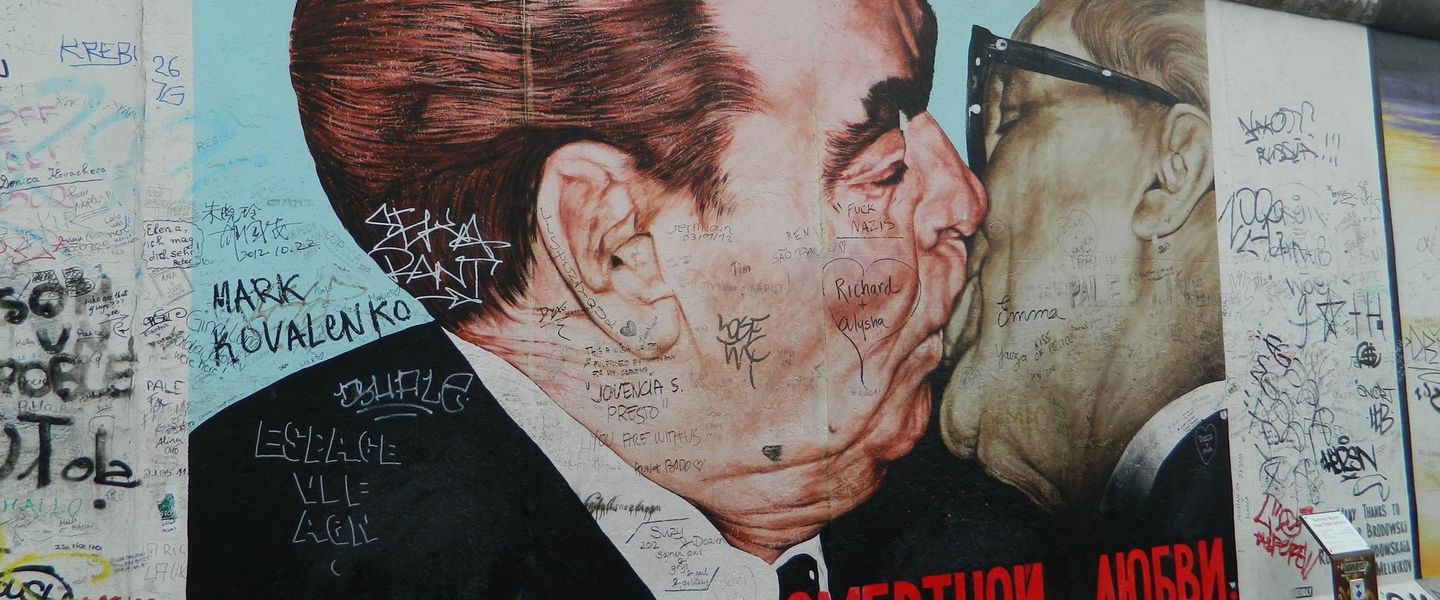


Friedrichshain, Berlin pairs the East Side Gallery, Karl-Marx-Allee, leafy parks, street food, independent shops, riverside walks and celebrated nightlife.
Streets Shaped by Two Berlins
Friedrichshain occupies the eastern side of central Berlin, stretching from the Spree and the East Side Gallery towards Volkspark Friedrichshain and the broad socialist boulevard of Karl-Marx-Allee. Its character comes from sharp contrasts: monumental post-war avenues meet Gründerzeit courtyards, former industrial sites, leafy residential streets and walls covered in large-scale contemporary murals. The neighbourhood is part of the borough of Friedrichshain-Kreuzberg, although Friedrichshain retains a distinct identity of its own.Read more about Friedrichshain
From Wall Art to Nightlife
Parks, Markets and Everyday Life
Best attractions in Friedrichshain
Friedrichshain’s attractions range from major historical sites to informal urban spaces. The East Side Gallery runs along Mühlenstraße beside the Spree, where murals painted on a surviving section of the Berlin Wall form an open-air gallery with a strong political and memorial dimension. Volkspark Friedrichshain provides wooded paths, lawns, ponds and the Märchenbrunnen, a sculptural fountain complex inspired by fairy tales. The Computerspielemuseum on Karl-Marx-Allee traces the history of digital games through an accessible collection of machines and interactive exhibits. Around the former railway workshops of RAW, visitors find a constantly changing mixture of cultural spaces, street art, climbing facilities and event venues. The neighbourhood’s everyday appeal also lies in walking between Boxhagener Platz, Simon-Dach-Straße and the broad residential avenues that reveal contrasting layers of Berlin’s twentieth-century history.
-
Plaza
Alexanderplatz
Explore Berlin's iconic Alexanderplatz: a historic hub with world-famous landmarks, vibrant shopping, and easy access to top attractions.
9 min drive · 2.9 km from neighbourhood centre
-
Tourist attraction
Berlin wall
Explore the Berlin Wall, a historical symbol of division and reunification, featuring striking art and poignant memorials that tell the story of a city's past.
14 min walk · 1.1 km from neighbourhood centre
-
Tourist attraction
Oberbaum City
Discover Oberbaum City: Where Berlin's history and modern culture unite on the iconic Oberbaum Bridge, a symbol of resilience and reunification.
11 min walk · 0.8 km from neighbourhood centre
-
Tourist attraction
Springbrunnen
A tranquil fountain in Friedrichshain-Kreuzberg, Berlin, offering a refreshing pause amidst the city's vibrant atmosphere.
17 min walk · 1.4 km from neighbourhood centre


Best landmarks in Friedrichshain
Friedrichshain’s landmarks express the political and architectural history of Berlin’s eastern districts. The East Side Gallery preserves a long section of the former Berlin Wall, its murals turning a once-forbidding border structure into a public record of reunification-era hopes and international artistic responses. Karl-Marx-Allee is distinguished by its vast scale, formal alignment and monumental residential architecture created during the GDR period, with Kino International among its best-known buildings. At the southern edge, the Oberbaum Bridge links Friedrichshain with Kreuzberg across the Spree; it is a nearby boundary landmark rather than a feature of the neighbourhood’s interior. Volkspark Friedrichshain, including the Märchenbrunnen, adds an important nineteenth-century civic landscape. Railway infrastructure around Ostbahnhof, Ostkreuz and Warschauer Straße further reveals how transport shaped the district’s growth.
-
Memorial
East Side Gallery
Experience history and art at the East Side Gallery, the world's largest open-air gallery on a remaining section of the Berlin Wall, symbolizing freedom and unity.
14 min walk · 1.1 km from neighbourhood centre
-
Park
Volkspark Friedrichshain
Discover Berlin's oldest public park: Volkspark Friedrichshain, a vibrant green space offering history, recreation, and natural beauty in the heart of the city.
6 min drive · 2.2 km from neighbourhood centre
-
Fountain
Märchenbrunnen
Discover the enchanting Märchenbrunnen in Berlin's Volkspark Friedrichshain: a neo-Baroque fairytale fountain adorned with sculptures from the Brothers Grimm, offering a whimsical escape for all ages.
8 min drive · 2.5 km from neighbourhood centre
-
Tourist attraction
Graffiti Wall of Fame
Experience Berlin's raw, unfiltered street art scene at the Graffiti Wall of Fame, a dynamic canvas where artists freely express themselves in the heart of Friedrichshain-Kreuzberg.
6 min walk · 0.4 km from neighbourhood centre


Explore Friedrichshain on the map
A handpicked selection of must-see spots in Friedrichshain, mapped for you.
Best hotels in Friedrichshain
Best restaurants in Friedrichshain
Friedrichshain has one of Berlin’s broadest casual dining landscapes, particularly around Boxhagener Platz, Simon-Dach-Straße, Grünberger Straße and the streets leading towards Warschauer Straße. The choice ranges from cafés and bakeries to Turkish, Vietnamese, Georgian, Middle Eastern, Italian and vegetarian cooking, reflecting Berlin’s international food culture rather than one single local cuisine. The neighbourhood is well suited to informal meals, takeaway dishes and long evenings at pavement tables, although the busiest streets can feel highly commercial and crowded. Food stalls and small eateries around markets add variety, while the former industrial spaces near RAW provide settings for food and drink alongside cultural events. Traditional Berlin specialities are available, but visitors will also encounter contemporary plant-based menus, international snacks and specialist coffee. Checking payment methods is sensible, as smaller establishments may still prefer cash or have minimum card amounts.
-
Italian
A Mano
Discover A Mano: Berlin's premier destination for authentic Italian cuisine and exquisite seafood dishes in a welcoming atmosphere.
6 min drive · 1.9 km from neighbourhood centre
-
Restaurant
Cafe Datscha
Discover authentic Eastern European flavors at Café Datscha in Berlin's vibrant Friedrichshain district—where comfort meets culinary delight.
5 min walk · 0.4 km from neighbourhood centre
-
Italian
Restaurant Trattoria Portofino
Savor authentic Italian flavors at Trattoria Portofino in Berlin - where every bite transports you to Italy's culinary heart.
4 min walk · 0.3 km from neighbourhood centre
-
Vietnamese
NYOM Restaurant
Discover authentic Vietnamese cuisine at NYOM Restaurant in Berlin's vibrant Friedrichshain-Kreuzberg district.
5 min walk · 0.4 km from neighbourhood centre


Best bars in Friedrichshain
After dark, Friedrichshain divides into several distinct nightlife zones. Simon-Dach-Straße and the streets around Boxhagener Platz are lined with bars and late-opening places for relaxed drinks, while the RAW complex has long been associated with music, cultural events and a rougher industrial setting. The area around Warschauer Straße is one of Berlin’s busiest evening corridors, with crowds moving between bars, venues and transport connections. Berghain, housed in a former power station near Ostbahnhof, gives the neighbourhood an internationally recognised connection with electronic music, although entry and opening arrangements are deliberately unpredictable and should never be assumed. Smaller music venues, cinemas and cultural spaces broaden the evening offer beyond clubbing. Noise, queues and street activity are concentrated around nightlife hubs, while residential streets nearby can become notably quieter.
-
Bar
Luft und Liebe Bar Berlin
Experience the vibrant nightlife of Berlin at Luft und Liebe Bar, where creative cocktails meet cozy atmospheres in Friedrichshain.
5 min walk · 0.4 km from neighbourhood centre
-
Irish pub
MacLaren's Pub
Discover the warmth and charm of MacLaren's Pub in Berlin, where hearty dishes and a vibrant atmosphere await every visitor.
4 min walk · 0.3 km from neighbourhood centre
-
Bar
Krass Böser Wolf
Experience Berlin's nightlife at Krass Böser Wolf, a vibrant bar in Friedrichshain-Kreuzberg, offering a wide selection of drinks and a lively atmosphere.
5 min drive · 1.7 km from neighbourhood centre
-
Bar
booze bar berlin
Experience the unique cocktails and vibrant atmosphere of Booze Bar Berlin, a must-visit nightlife spot in Friedrichshain-Kreuzberg.
6 min walk · 0.5 km from neighbourhood centre


Best nightclubs in Friedrichshain
After dark, Friedrichshain divides into several distinct nightlife zones. Simon-Dach-Straße and the streets around Boxhagener Platz are lined with bars and late-opening places for relaxed drinks, while the RAW complex has long been associated with music, cultural events and a rougher industrial setting. The area around Warschauer Straße is one of Berlin’s busiest evening corridors, with crowds moving between bars, venues and transport connections. Berghain, housed in a former power station near Ostbahnhof, gives the neighbourhood an internationally recognised connection with electronic music, although entry and opening arrangements are deliberately unpredictable and should never be assumed. Smaller music venues, cinemas and cultural spaces broaden the evening offer beyond clubbing. Noise, queues and street activity are concentrated around nightlife hubs, while residential streets nearby can become notably quieter.
-
Night club
Cassiopeia
Discover the heart of Berlin's nightlife at Cassiopeia, a unique venue with a night club, beer garden, and concert hall.
6 min walk · 0.5 km from neighbourhood centre
-
Night club
Renate
Discover the enchanting nightlife at Renate, a unique Berlin night club filled with eclectic decor and vibrant music that promises an unforgettable experience.
5 min drive · 1.8 km from neighbourhood centre
-
Night club
://about blank
Discover the vibrant atmosphere and eclectic music scene at ://about blank, a premier night club in Berlin's Friedrichshain-Kreuzberg district.
17 min walk · 1.4 km from neighbourhood centre
-
Night club
AVA CLUB
Dive into Berlin's nightlife at AVA Club, where pulsating beats and vibrant crowds create an unforgettable experience in the heart of the city.
12 min walk · 1.0 km from neighbourhood centre


Best shops in Friedrichshain
Shopping in Friedrichshain is concentrated in independent, mixed-use streets rather than a single conventional retail centre. Around Boxhagener Platz, Grünberger Straße, Wühlischstraße and Simon-Dach-Straße, visitors find small fashion shops, bookshops, design stores, cafés and specialist businesses interspersed with everyday services. The area around RAW has a more alternative, creative atmosphere, although its uses and individual businesses can change over time. Boxhagener Platz hosts different forms of market activity, including regular second-hand and flea-market trading, making it a useful place to browse vintage objects, household goods and collectables when markets are operating. Larger mainstream retail is available at Ring-Center near Frankfurter Allee, close to the neighbourhood’s northern edge. Friedrichshain is best approached as a district for browsing independent shops and local streets rather than for luxury shopping or a tightly defined craft tradition.
-
Boutique
Coexist
Explore Coexist, a unique boutique in Berlin's Friedrichshain-Kreuzberg, offering curated treasures and local artistry.
4 min walk · 0.4 km from neighbourhood centre
-
Gift shop
HEY ALEX
Explore the unique charm of Hey Alex, a boutique in Berlin offering stylish fashion accessories, clothing, and distinctive gifts.
6 min walk · 0.5 km from neighbourhood centre
-
Gift shop
Broke + Schön Fhain
Explore Berlin's creative heartbeat at Broke + Schön Fhain, where unique gifts and fashion meet local artistry in a charming boutique setting.
7 min walk · 0.6 km from neighbourhood centre
-
Vintage clothing store
Berliner Modeinstitut
Discover the unique charm of vintage fashion and accessories at Berliner Modeinstitut, a must-visit boutique in Berlin's vibrant Friedrichshain district.
6 min walk · 0.4 km from neighbourhood centre


Friedrichshain essentials
Getting There
Getting Around
Safety
Emergency Situations
Do's and Don'ts
Local Tips

From Eve
Local phrases worth knowing
You don't need to get them perfect. A few words go a long way, and locals appreciate the effort.
Basics
| English | Local | Say it |
|---|---|---|
| Hello | Hallo | [hah-loh] |
| Goodbye | Auf Wiedersehen | [owf vee-der-zay-en] |
| Yes | Ja | [yah] |
| No | Nein | [nine] |
| Please/You're welcome | Bitte | [bit-teh] |
| Thank you | Danke | [dahn-keh] |
| Excuse me/Sorry | Entschuldigung | [ent-shool-dee-goong] |
| How are you? | Wie geht es dir? | [vee gayt es deer] |
| Fine. And you? | Gut. Und dir? | [goot oond deer] |
| Do you speak English? | Sprichst du Englisch? | [shprikhst doo eng-lish] |
| I don't understand | Ich verstehe nicht | [ikh fer-shteh-eh nikht] |
Eating & Drinking
| English | Local | Say it |
|---|---|---|
| I'd like to see the menu, please | Ich möchte bitte die Speisekarte sehen | [ikh merkh-teh bit-teh dee shpy-ze-kahr-teh zay-en] |
| I don't eat meat | Ich esse kein Fleisch | [ikh es-se kine flysh] |
| Cheers! | Prost! | [prohst] |
| I would like to pay, please | Ich möchte bitte zahlen | [ikh merkh-teh bit-teh tsah-len] |
Emergencies
| English | Local | Say it |
|---|---|---|
| Help! | Hilfe! | [hil-feh] |
| Go away! | Geh weg! | [gey vehg] |
| Call the Police! | Rufe die Polizei! | [roo-fee dee poh-lee-tsay] |
| Call a doctor! | Rufe einen Arzt! | [roo-fee igh-nen ahrts] |
| I'm lost | Ich habe mich verirrt | [ikh hah-beh meekh fer-eert] |
| I'm ill | Ich bin krank | [ikh bin krahnk] |
Shopping
| English | Local | Say it |
|---|---|---|
| I'd like to buy... | Ich möchte ... kaufen | [ikh merkh-teh ... kow-fen] |
| I'm just looking | Ich schaue nur | [ikh shou-eh noor] |
| How much is it? | Wie viel kostet es? | [vee feel koh-stet es] |
| That's too expensive | Das ist zu teuer | [dahs ist tso toy-er] |
| Can you lower the price? | Kannst du den Preis senken? | [kahnst doo den prees zehn-ken] |
Time & Numbers
| English | Local | Say it |
|---|---|---|
| What time is it? | Wie spät ist es? | [vee shpayt ist es] |
| It's one o'clock | Es ist ein Uhr | [es ist ighn oor] |
| Half past (10) | Halb elf | [halb elf] |
| Morning | Morgen | [mohr-gn] |
| Afternoon | Nachmittag | [nahk-mit-tahk] |
| Evening | Abend | [ah-bnt] |
| Yesterday | Gestern | [geh-stern] |
| Today | Heute | [hoy-teh] |
| Tomorrow | Morgen | [mohr-gn] |
| 1 | Eins | [ighns] |
| 2 | Zwei | [tsvay] |
| 3 | Drei | [drigh] |
| 4 | Vier | [feer] |
| 5 | Fünf | [foontf] |
| 6 | Sechs | [zeks] |
| 7 | Sieben | [zee-bn] |
| 8 | Acht | [ahkt] |
| 9 | Neun | [noyn] |
| 10 | Zehn | [tsehn] |
Transport & Directions
| English | Local | Say it |
|---|---|---|
| Where's a/the...? | Wo ist ...? | [vo ist] |
| What's the address? | Was ist die Adresse? | [vas ist dee ah-dreh-say] |
| Can you show me (on the map)? | Kannst du mir zeigen (auf der Karte)? | [kahnst doo meer tsay-gen (ouf der kar-teh)] |
| When's the next (bus)? | Wann kommt der nächste (Bus)? | [vahn kommt der nekhs-te (boos)] |
| A ticket (to ....) | Eine Fahrkarte (nach ....) | [igh-nuh fahr-kahr-teh (nahkh)] |
History of Friedrichshain
The Park and Friedrich’s Name
The area takes its name from Friedrich II of Prussia, while Friedrichshain itself means Friedrich’s grove or woodland. Before dense urbanisation, the eastern edge of Berlin consisted largely of agricultural land, gardens and open ground outside the old city. Volkspark Friedrichshain was laid out from 1840 to mark the centenary of Friedrich II’s accession, becoming Berlin’s first municipal public park. Its creation signalled the area’s gradual transformation from peripheral land into a planned extension of the growing capital, with later streets and housing developing around the park’s paths and edges.
Industrial Expansion and Tenement Streets
During the second half of the nineteenth century, Friedrichshain was absorbed into Berlin’s rapid industrial and residential expansion. Factories, railway infrastructure and densely built Mietskasernen—large tenement blocks organised around courtyards—appeared alongside workers’ housing and small businesses. The neighbourhood’s position near the Frankfurter Tor corridor and the expanding railway network encouraged manufacturing and movement eastwards. Although many courtyards have since been renovated or converted, the pattern of perimeter blocks, side streets and mixed commercial ground floors still explains much of Friedrichshain’s urban form.
War, Division and Reconstruction
The Second World War brought severe damage to parts of Friedrichshain, and the division of Berlin placed the neighbourhood in the city’s eastern sector. Reconstruction was particularly visible along former Große Frankfurter Straße, redesigned from the late 1940s as Stalinallee and later renamed Karl-Marx-Allee. Its broad boulevard and monumental residential buildings expressed the architectural and political ideals of the German Democratic Republic. Friedrichshain was also connected to the workers’ uprising of 17 June 1953, when protests began among construction workers on Stalinallee before spreading across East Berlin.
The Wall and East Side Gallery
When the Berlin Wall was built in 1961, its riverside line divided Friedrichshain from Kreuzberg across the Spree and shaped daily life around Ostbahnhof and the former industrial waterfront. After the Wall fell in 1989, artists from many countries painted the surviving inner section along Mühlenstraße in 1990. The resulting East Side Gallery became an open-air collection of political and symbolic murals, including Dmitri Vrubel’s image of the fraternal kiss. Its preservation reflects the neighbourhood’s transition from a fortified border zone to a major site of Berlin’s memory culture.
Reuse, Renewal and Rising Pressures
Since reunification, Friedrichshain has experienced extensive renovation, new construction and the conversion of former railway and industrial premises. Sites such as RAW developed through informal and cultural reuse, while the area around Boxhagener Platz and Simon-Dach-Straße gained cafés, restaurants, bars and creative businesses. The former East German housing stock attracted new residents and investment, bringing improvements but also higher rents and debates about displacement. Friedrichshain’s contemporary identity therefore combines preserved socialist architecture, nightlife and creative infrastructure with the ongoing pressures of central Berlin’s property market.
Friedrichshain in Photos
Browse through our photo collection highlighting the charm and character of the destination.
Neighbourhoods near Friedrichshain
The closest neighbourhoods to Friedrichshain, if you have time for more than one stop.
-
-

-

-


Swipe for more neighbourhoods
Explore more

Explore more of Berlin
Berlin blends Prussian grandeur, Cold War history, world-class museums, creative neighbourhoods and memorable urban culture across Germany’s lively capital.
Explore Berlin