

Wonokromo (Surabaya) Travel Guide - Free
Explore Wonokromo in Surabaya with Evendo's free guide. Find the best shops, historic streets, restaurants, and gems on web or mobile.


Wonokromo in Surabaya blends traditional markets, Surabaya Zoo, Taman Bungkul, railway heritage and riverside city life in one southern district.
A Southern Crossroads
Wonokromo occupies a busy, varied stretch of southern Surabaya, where railway lines, major roads, the Kalimas-linked waterway system and densely settled streets meet. It is both a recognised district, or kecamatan, and a collection of local areas including Wonokromo, Jagir, Sawunggaling, Ngagelrejo and Darmo. For visitors, its identity is less about a single picturesque quarter than about movement: commuters pass through Wonokromo Station, shoppers converge on Pasar Wonokromo and Darmo Trade Center, and families head to Surabaya Zoo or the open lawns of Taman Bungkul.Read more about Wonokromo
Markets, Parks and Everyday Surabaya
Water, Wildlife and Urban Change
Best landmarks in Wonokromo
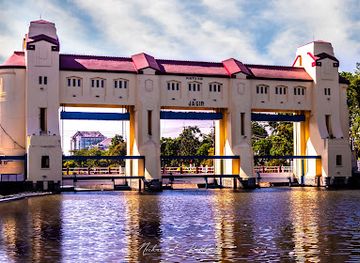
Wonokromo Station is the district’s clearest built landmark, representing the railway infrastructure that turned Surabaya’s southern edge into a major gateway. Pasar Wonokromo provides a different kind of local landmark: its significance lies in the scale of its trading function and its relationship with the station, roads and surrounding neighbourhoods. The Jagir water-control area, including the Wonokromo river and canal system, is important evidence of the engineering landscape that has helped manage Surabaya’s low-lying terrain. In the Darmo section, Taman Bungkul is a civic landmark rather than a historic monument, recognised for its public role and landscaped setting. Surabaya Zoo is also physically prominent, its long presence making it part of the district’s modern identity. Together these places express transport, commerce, water management, recreation and urban memory.
-
Landmark
Pintu Air Jagir
Discover the historical charm of Pintu Air Jagir, Surabaya's iconic landmark showcasing rich cultural heritage and stunning architecture.
12 min walk · 1.0 km from neighbourhood centre
-
Garden
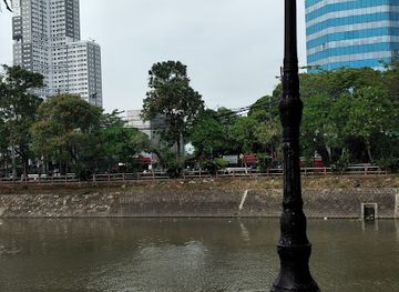
Oude Ned-indië Stuwbrug bij de Rivier de Djagir
Experience the serene beauty of Oude Ned-Indië Stuwbrug, a hidden garden gem in Surabaya perfect for nature lovers and tranquil escapes.
12 min walk · 1.0 km from neighbourhood centre
-
Historical landmark
Eks PJL Percabangan Wonokromo
Explore Eks PJL Percabangan Wonokromo, a historical landmark in Surabaya, where the past meets the vibrant culture of East Java.
15 min walk · 1.2 km from neighbourhood centre

Explore Wonokromo on the map
A handpicked selection of must-see spots in Wonokromo, mapped for you.
Best hotels in Wonokromo
Best restaurants in Wonokromo
Eating in Wonokromo is closely tied to movement and daily commerce. Around Wonokromo Station, Pasar Wonokromo and the roads leading towards Jalan Raya Darmo, visitors encounter Indonesian staples served at modest warungs, food carts and small family-run eateries, including rice dishes, noodles, fried snacks, soups and sweet drinks. The market environment is particularly useful for observing how fresh produce and prepared food circulate through the neighbourhood, while the retail area around Darmo Trade Center offers more conventional casual dining. Surabaya’s East Javanese flavours appear in the wider street-food mix, often with assertive sambal and savoury broths, though individual stalls and menus change. Taman Bungkul also has an established association with informal food sellers and evening snacking, making the park area a relaxed place to sample local dishes without confusing the district with the city’s more formal restaurant quarters.
-
Balinese restaurant
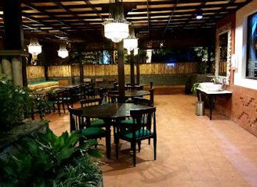
Restoran Bebek Tepi Sawah Surabaya
Savor authentic Balinese cuisine in a serene setting at Restoran Bebek Tepi Sawah Surabaya - where every meal is a delightful escape.
15 min walk · 1.2 km from neighbourhood centre
Wonokromo essentials
Getting There
Getting Around
Safety
Emergency Situations
Do's and Don'ts
Local Tips

From Eve
Local phrases worth knowing
You don't need to get them perfect. A few words go a long way, and locals appreciate the effort.
Basics
| English | Local | Say it |
|---|---|---|
| Hello | Halo | [ha-loh] |
| Goodbye | Selamat tinggal | [seh-lah-maht ting-gahl] |
| Yes | Ya | [yah] |
| No | Tidak | [tee-dahk] |
| Please/You're welcome | Silakan | [see-lah-kahn] |
| Thank you | Terima kasih | [tuh-ree-mah kah-see] |
| Excuse me/Sorry | Maaf | [mah-ahf] |
| How are you? | Apa kabar? | [ah-pah kah-bahr] |
| Fine. And you? | Baik. Bagaimana denganmu? | [bah-eek. bah-gai-mah-nah dehng-ahn-moo] |
| Do you speak English? | Apakah kamu bisa berbahasa Inggris? | [ah-pah-kah kah-moo bee-sah buhr-bah-hah-sah eeng-grees] |
| I don't understand | Saya tidak mengerti | [sah-yah tee-dahk mehng-gehr-tee] |
Eating & Drinking
| English | Local | Say it |
|---|---|---|
| I'd like to see the menu, please | Saya ingin melihat menu, tolong | [sah-yah een-geen meh-lee-haht meh-noo toh-lohng] |
| I don't eat meat | Saya tidak makan daging | [sah-yah tee-dahk mah-kahn dah-yahng] |
| Cheers! | Selamat minum! | [seh-lah-maht mee-noom] |
| I would like to pay, please | Saya ingin membayar, tolong | [sah-yah een-geen mehm-bah-yahr toh-lohng] |
Emergencies
| English | Local | Say it |
|---|---|---|
| Help! | Tolong! | [toh-lohng] |
| Go away! | Pergi! | [pehr-gee] |
| Call the Police! | Panggil polisi! | [pahng-geel poh-lee-see] |
| Call a doctor! | Panggil dokter! | [pahng-geel dohk-tehr] |
| I'm lost | Saya tersesat | [sah-yah tuhr-seh-saht] |
| I'm ill | Saya sakit | [sah-yah sah-keet] |
Shopping
| English | Local | Say it |
|---|---|---|
| I'd like to buy... | Saya ingin membeli... | [sah-yah een-geen mehm-beh-lee] |
| I'm just looking | Saya hanya melihat-lihat | [sah-yah hahn-yah meh-lee-haht-lee-haht] |
| How much is it? | Berapa harganya? | [beh-rah-pah hahr-gahn-yah] |
| That's too expensive | Itu terlalu mahal | [ee-too tuhr-lah-loo mah-hahl] |
| Can you lower the price? | Bisa kurangi harganya? | [bee-sah koo-rang-gee hahr-gahn-yah] |
Time & Numbers
| English | Local | Say it |
|---|---|---|
| What time is it? | Jam berapa sekarang? | [jahm beh-rah-pah seh-kah-rahng] |
| It's one o'clock | Sekarang pukul satu | [seh-kah-rahng poo-kool sah-too] |
| Half past (10) | Setengah (sepuluh) | [seh-tehn-gah (seh-poo-looh)] |
| Morning | Pagi | [pah-gee] |
| Afternoon | Sore | [soh-reh] |
| Evening | Malam | [mah-lahm] |
| Yesterday | Kemarin | [keh-mah-reen] |
| Today | Hari ini | [hah-ree ee-nee] |
| Tomorrow | Besok | [beh-sohk] |
| 1 | Satu | [sah-too] |
| 2 | Dua | [doo-ah] |
| 3 | Tiga | [tee-gah] |
| 4 | Empat | [em-paht] |
| 5 | Lima | [lee-mah] |
| 6 | Enam | [eh-nahm] |
| 7 | Tujuh | [too-joo] |
| 8 | Delapan | [deh-lah-pahn] |
| 9 | Sembilan | [sehm-bee-lahn] |
| 10 | Sepuluh | [seh-poo-looh] |
Transport & Directions
| English | Local | Say it |
|---|---|---|
| Where's a/the...? | Dimana ada/...? | [dee-mah-nah ah-dah/...?] |
| What's the address? | Berapa alamatnya? | [beh-rah-pah ah-lah-maht-nyah] |
| Can you show me (on the map)? | Bisa tunjukkan pada saya (di peta)? | [bee-sah toon-jook-kahn pah-dah sah-yah (dee peh-tah)?] |
| When's the next (bus)? | Kapan yang berikutnya (bus)? | [kah-pahn yahng beh-ree-koot-nyah (boos)?] |
| A ticket (to ....) | Tiket (ke ....) | [tee-keht (keh ....)] |
History of Wonokromo
A Rural Southern Approach
Before southern Surabaya became a dense urban corridor, the area around present-day Wonokromo was part of the city’s outer landscape of waterways, cultivated land and village settlements. The name is commonly associated with the local toponym Wonokromo, although explanations of its exact linguistic history vary. Its position south of the older urban core mattered because roads and watercourses funnelled movement towards the interior of East Java. Over time, settlement spread along these routes, turning a peripheral landscape into a crucial approach to Surabaya.
Railways and Urban Connection
The expansion of railways in the late nineteenth century strengthened Wonokromo’s role as a transport gateway. Wonokromo Station connected the southern edge of Surabaya with routes towards destinations including Sidoarjo and Malang, linking local markets and settlements with the colonial city’s commercial network. Railway land, level crossings and associated roads encouraged denser development around the corridor. The station remains an important marker of the district’s history, although today it serves a far larger metropolitan population than the early railway planners could have anticipated.
Water Management at Jagir
Wonokromo’s development also reflects Surabaya’s long effort to manage rivers, drainage and flooding. The Jagir area became associated with hydraulic works on the Brantas water system and with the division and control of flows entering the urban landscape. These structures were not simply engineering constructions: they influenced settlement, roads, agriculture and later industrial growth around the southern city. The canals and water infrastructure visible around Wonokromo are reminders that Surabaya’s expansion depended on regulating a wet, low-lying environment.
Markets, Parks and Metropolitan Growth
During the twentieth century, roads, public transport and population growth absorbed Wonokromo into the built-up city. Pasar Wonokromo developed as a major everyday trading centre, while the railway station and road junctions brought a steady flow of workers, shoppers and goods. Later public-space investment, particularly around Taman Bungkul in Darmo, introduced a greener civic dimension to the district. Today Wonokromo combines older market and transport functions with retail redevelopment, residential neighbourhoods and improved public amenities, making it a useful lens through which to observe Surabaya’s continuing urban change.
Wonokromo in Photos
Browse through our photo collection highlighting the charm and character of the destination.
Neighbourhoods near Wonokromo
The closest neighbourhoods to Wonokromo, if you have time for more than one stop.
-

-

-

-


Swipe for more neighbourhoods
Explore more

Explore more of Surabaya
Surabaya blends colonial streets, heroic history, East Javanese cuisine and lively markets with Madura and Mount Bromo nearby for culture-rich city breaks.
Explore Surabaya