

Causeway Coastal Route Travel Guide - Free Web & App
Your ultimate guide to Causeway Coastal Route. Discover top landmarks, proposed trips, and local tips. Free on the web or via the Evendo companion app.


Causeway Coastal Route in Ireland links the Giant’s Causeway, Antrim Coast cliffs, Carrick-a-Rede, castles, beaches and harbour towns on a scenic coastal drive.
Coastal Landscapes and Geological Drama
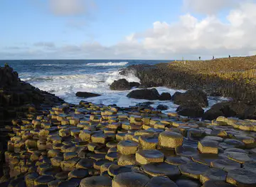
The Causeway Coastal Route follows one of the most varied shores on the island of Ireland, linking Belfast with Derry-Londonderry through the coastal scenery of County Antrim and the northern edge of County Londonderry. The route is commonly described as running through Northern Ireland, which is part of the United Kingdom, although its landscapes and communities form part of the wider island of Ireland. Along the way, basalt headlands, wave-cut cliffs, sandy bays, green glens and exposed beaches create a journey in which the terrain changes repeatedly over relatively short distances. Its defining natural landmark is the Giant’s Causeway, a UNESCO World Heritage Site formed from approximately 40,000 interlocking basalt columns.Read more about Causeway Coastal Route
Villages, Harbours and Heritage
Exploring the Route
When is the best time to visit Causeway Coastal Route?
Best: June–August · 18–20°C| Month | High (°C) | Rainfall (mm) |
|---|---|---|
| January | 9 | 100 |
| February | 9 | 90 |
| March | 10 | 80 |
| April | 12 | 70 |
| May | 15 | 60 |
| June (best) | 18 | 50 |
| July (best) | 20 | 45 |
| August (best) | 20 | 50 |
| September | 17 | 70 |
| October | 14 | 80 |
| November | 12 | 90 |
| December | 11 | 95 |
Getting to and around Causeway Coastal Route
How to get there
Transportation
Best attractions in Causeway Coastal Route
The Giant’s Causeway is the route’s signature attraction, where thousands of basalt columns descend towards the sea and form one of Europe’s best-known geological landscapes. Nearby, the Causeway Coast offers cliff paths, sea stacks and views towards Rathlin Island, while Carrick-a-Rede rope bridge provides access to a small offshore island above the Atlantic, subject to operational and weather conditions. Dunluce Castle occupies a dramatic headland between Bushmills and Portrush, and the distillery town of Bushmills adds industrial heritage to the coastal journey. Ballycastle is a useful base for exploring Fair Head, Rathlin Island and the eastern coast, while Cushendun and Cushendall open the way into the Glens of Antrim. Further west, Portstewart Strand and the beaches around Portrush provide broad sands and open sea views, whereas Carrickfergus brings a substantial medieval castle and harbour history to the route’s Belfast end.
-
Tourist attraction
Giant's Causeway
Explore the Giant's Causeway: a UNESCO World Heritage Site with unique basalt columns, formed by volcanoes and steeped in Irish legend.
-
Visitor center
National Trust - Giant's Causeway Visitor Centre
Explore the Giant's Causeway: Where geology meets legend on Northern Ireland's stunning coast. Visitor Centre with tours, exhibits, and more.
-
Tourist attraction
Giant's Causeway & Bushmills Railway
Ride a vintage train along the scenic Causeway Coast, connecting Bushmills to the Giant's Causeway on a historic railway journey.
-
Tourist attraction
Shepherd's Steps
Ascend the Shepherd's Steps for breathtaking views of the Giant's Causeway, Northern Ireland's iconic coastal wonder.


Best landmarks in Causeway Coastal Route
The Giant’s Causeway is the defining natural landmark, its regular basalt columns recording the cooling of ancient lava and giving the surrounding coast its geological identity. Fair Head near Ballycastle forms a high, dark headland with expansive views across the sea, while the cliffs and offshore rocks around the Causeway and Portballintrae demonstrate the continuing force of coastal erosion. Dunluce Castle is the most evocative historic landmark on the central route, standing above a narrow rocky promontory, and Carrickfergus Castle anchors the eastern approach with its substantial medieval fortifications beside Belfast Lough. Carrick-a-Rede rope bridge is both a modern visitor structure and a reminder of the coast’s historic salmon-fishing crossings. The Glens of Antrim, Rathlin Island and the broad strands near Portrush complete a landmark landscape in which geological, maritime and cultural features are closely connected.
-
Nature preserve
Giant's Causeway
Explore the Giant's Causeway: Awe-inspiring basalt columns, shaped by volcanic forces and steeped in Irish legend, on Northern Ireland's stunning coast.

Explore Causeway Coastal Route on the map
Plan your trip on one map. See where the top attractions, landmarks, restaurants and hotels are, and book hotels and experiences in a few clicks.
Best hotels in Causeway Coastal Route
Best restaurants in Causeway Coastal Route
Dining along the Causeway Coastal Route is concentrated in coastal towns and villages rather than at isolated viewpoints. Ballycastle, Bushmills, Portrush, Portstewart, Cushendall and Carrickfergus provide the broadest choice of restaurants, cafés, bakeries, traditional pubs and casual seafood dining, while smaller settlements may have a more limited selection. Local menus often draw on North Atlantic fish and shellfish, Northern Irish beef and lamb, potatoes, dairy produce and seasonal vegetables from County Antrim and the surrounding farmland. Bushmills is associated with Irish whiskey production, and the wider region has a strong tradition of tea rooms, farmhouse produce and hearty pub food. Visitors staying in rural accommodation should not assume that an evening meal is available nearby and may need to plan around opening patterns, particularly outside the main tourist season.
-
Restaurant
The Nook
Discover fresh seafood delights at The Nook along Northern Ireland's stunning Causeway Coast - where every meal is a taste of local heritage.
-
Cafe
National trust cafe
Discover comfort and flavor at the National Trust Cafe in Bushmills - your perfect stop amidst stunning landscapes and rich heritage.
-
Mobile caterer
Hungry Giant Causeway
Experience local flavors amidst breathtaking scenery at Hungry Giant Causeway – where delicious food meets iconic landscapes.


Best bars in Causeway Coastal Route
Evenings on the Causeway Coastal Route are generally sociable and low-key rather than centred on clubs. Traditional pubs in villages such as Ballycastle, Cushendall, Bushmills and Cushendun provide places for conversation, local beer, whiskey and, at times, traditional music, although performances and opening patterns vary. Portrush and Portstewart have the liveliest evening scenes because they are established seaside resorts with larger populations of visitors during the warmer months. Coleraine and Carrickfergus offer further pubs and restaurants outside the smaller coastal settlements, while rural areas become quiet after dark. The coast’s evening appeal also lies in harbour views, long summer twilight and clear night skies, but visitors should arrange transport in advance rather than assume that late public services connect every village.
-
Restaurant
The Nook
Experience the essence of coastal cuisine at The Nook, a charming seafood restaurant in Bushmills, where every dish celebrates local flavors.

Get your free copy of our complete guide to Causeway Coastal Route, delivered straight to you.
Everything on this page, from attractions and restaurants to essentials and local phrases, in one PDF you can read offline, print or share.
Already have an account? Sign in
Your Causeway Coastal Route guide is ready.
We'll send it to · Not you? Sign out

Getting your guide ready…
We are putting together a fresh copy of the Causeway Coastal Route guide. This can take up to a minute.
This can take a few moments. If your browser asks, choose Allow so the download can start. You'll find the guide in your Downloads folder.
Nothing happened? Download it again
Sorry, the guide is taking longer than usual. Please try again in a minute, or get it by email instead.
Causeway Coastal Route essentials
Currency and Payment
Safety
Emergency Situations
Do's and Don'ts
Local Tips
From Eve
Local phrases worth knowing
You don't need to get them perfect. A few words go a long way, and locals appreciate the effort.
Basics
| English | Local | Say it |
|---|---|---|
| Hello | Dia duit | [dee-ah gwit] |
| Goodbye | Slán | [slawn] |
| Yes | Tá | [taw] |
| No | Níl | [neel] |
| Please/You're welcome | Le do thoil | [leh duh hull] |
| Thank you | Go raibh maith agat | [goh rev mah ag-at] |
| Excuse me/Sorry | Maith thú | [mah hoo] |
| How are you? | Conas atá tú? | [kun-us ah-taw too] |
| Fine. And you? | Tá mé go maith. Agus tú? | [taw may goh mah. ah-gus too] |
| Do you speak English? | An bhfuil Béarla agat? | [ahn wul bayr-lah ag-at] |
| I don't understand | Ní thuigim | [nee hug-im] |
Eating & Drinking
| English | Local | Say it |
|---|---|---|
| I'd like to see the menu, please | Ba mhaith liom breathnú ar an mianúl, le do thoil | [ba wah lyum brath-noo air un me-an-ool, leh duh hull] |
| I don't eat meat | Ní ithim feoil | [nee ih-him foh-il] |
| Cheers! | Sláinte! | [slawn-cheh] |
| I would like to pay, please | Ba mhaith liom íoc, le do thoil | [ba wah lyum ee-uck, leh duh hull] |
Emergencies
| English | Local | Say it |
|---|---|---|
| Help! | Cabhraigh! | [kow-ree] |
| Go away! | Imigh! | [ih-mee] |
| Call the Police! | Glan an Garda! | [glon ahn gar-dah] |
| Call a doctor! | Glan dochtúir! | [glon dohk-too-ir] |
| I'm lost | Tá mé caillte | [taw may kal-cha] |
| I'm ill | Tá mé tinn | [taw may tin] |
Shopping
| English | Local | Say it |
|---|---|---|
| I'd like to buy... | Ba mhaith liom ceannach... | [ba wah lyum kya-nukh] |
| I'm just looking | Níl mé ach ag féachaint | [neel may okh eg fay-ak-ent] |
| How much is it? | Cé mhéad atá air? | [kay vade ah-taw air] |
| That's too expensive | Tá sé ró-dhaor | [taw shay ro-dheer] |
| Can you lower the price? | An féidir leat an praghas a laghdú? | [ahn fay-djir lat an prah-gus a lah-goo] |
Time & Numbers
| English | Local | Say it |
|---|---|---|
| What time is it? | Cén t-am é? | [kayn tahm ay] |
| It's one o'clock | Tá sé a haon a chlog | [taw shay ah hayn ah khlog] |
| Half past (10) | Leathuair tar éis a deich | [lah-hoo-ir tar aysh ah deh] |
| Morning | Maidin | [mah-djin] |
| Afternoon | Tráthnóna | [traw-noh-nah] |
| Evening | Tráthnóna | [traw-noh-nah] |
| Yesterday | Inné | [in-ay] |
| Today | Inniu | [in-yoo] |
| Tomorrow | Amárach | [ah-mar-ahkh] |
| 1 | Aon | [ayn] |
| 2 | Dó | [doh] |
| 3 | Trí | [tree] |
| 4 | Ceathair | [cah-her] |
| 5 | Cúig | [koo-ig] |
| 6 | Sé | [shay] |
| 7 | Seacht | [shokht] |
| 8 | Ocht | [ukht] |
| 9 | Naoi | [nee] |
| 10 | Deich | [deh] |
Transport & Directions
| English | Local | Say it |
|---|---|---|
| Where's a/the...? | Cá bhfuil an...? | [kaw wul ahn] |
| What's the address? | Cad é an seoladh? | [kahd ay ahn shawl-ah] |
| Can you show me (on the map)? | An féidir leat taispeáint dom (ar an léarscáil)? | [ahn fay-djir lat tash-paynt dum (ar ahn layr-skawl)] |
| When's the next (bus)? | Cén uair an chéad (bus)? | [kayn oo-ir ahn khayd (bus)] |
| A ticket (to ....) | Ticéad (go dtí ....) | [tick-ayd (guh dee)] |
History of Causeway Coastal Route
Volcanic Origins of the Coast
The Causeway Coast was shaped by volcanic activity during the Palaeogene Period, roughly 60 million years ago, when molten basalt cooled and contracted into the striking polygonal columns now associated with the Giant’s Causeway and nearby headlands. Subsequent erosion by ice, rain and the sea exposed and sculpted these formations into cliffs, platforms and sea stacks. The geological relationship between the Giant’s Causeway and the broader north Antrim coast explains why similar basalt landscapes appear at places such as Fair Head and around Rathlin Island, although the Giant’s Causeway is the area’s most celebrated example.
Early Settlement and Gaelic Society
People have lived around the north coast and the Glens of Antrim since prehistoric times, using fertile valleys, sheltered bays and upland pasture for settlement and farming. Early Christian foundations and medieval church sites survive in parts of the wider region, while Gaelic lordships shaped political and cultural life before the arrival of stronger English and Scottish influence. Rathlin Island, the Glens and the coastal settlements maintained strong local identities, connected by rough tracks and sea routes rather than by the engineered roads used by modern visitors.
Castles, Lordships and Coastal Power
During the medieval period, the north Antrim coast was contested by Gaelic families and Scottish-connected powers. Dunluce Castle became the stronghold of the MacDonnell family, whose influence extended across parts of the coastal region, while Carrickfergus Castle served as a major Anglo-Norman and later English military base on Belfast Lough. The castles were not isolated monuments but centres of authority controlling land, harbours and movement along a strategically important coast. Their ruins and surviving walls provide some of the clearest evidence of the political rivalries that shaped medieval and early modern Ulster.
Roads, Harbours and the Rise of Tourism
Improved roads and coastal connections gradually made the north coast more accessible from Belfast and inland market towns. Fishing harbours such as Ballycastle and Portstewart developed alongside farming communities, while Bushmills became associated with whiskey production. From the eighteenth and nineteenth centuries, visitors were increasingly drawn to the Giant’s Causeway, whose unusual columns inspired scientific debate, folklore and early tourism. Seaside resorts, railway links and illustrated travel accounts helped establish the coast as a recognised scenic destination, while bridges, castles and glens added cultural interest to the geological landmark.
Conservation and the Modern Route
The Giant’s Causeway and Causeway Coast became a focus of formal heritage protection as scientific and public appreciation grew. The Giant’s Causeway and Causeway Coast was inscribed as a UNESCO World Heritage Site in 1986 for its geological importance, and the surrounding coastline is managed through a combination of protected landscapes, public access arrangements and conservation work. Modern tourism has developed around a linear coastal itinerary linking Belfast and Derry-Londonderry, but the route still depends on working villages, farms, fishing traditions and fragile cliffs. Responsible access remains important where erosion, nesting birds and weather affect the coast.
Causeway Coastal Route in Photos
Browse through our photo collection highlighting the charm and character of the destination.
Neighbouring destination travel guides
The closest destinations to Causeway Coastal Route, if you have time for more than one.
-
-

-

-

-


Swipe for more destinations
Explore more
Explore more of Ireland
Discover Ireland: A land of enchanting landscapes, rich history, and vibrant culture, where every corner tells a story and every visit feels like coming home.
Explore Ireland