

Hardangervidda National Park Travel Guide - Free Web & App
Your ultimate guide to Hardangervidda National Park. Discover top landmarks, proposed trips, and local tips. Free on the web or via the Evendo companion app.


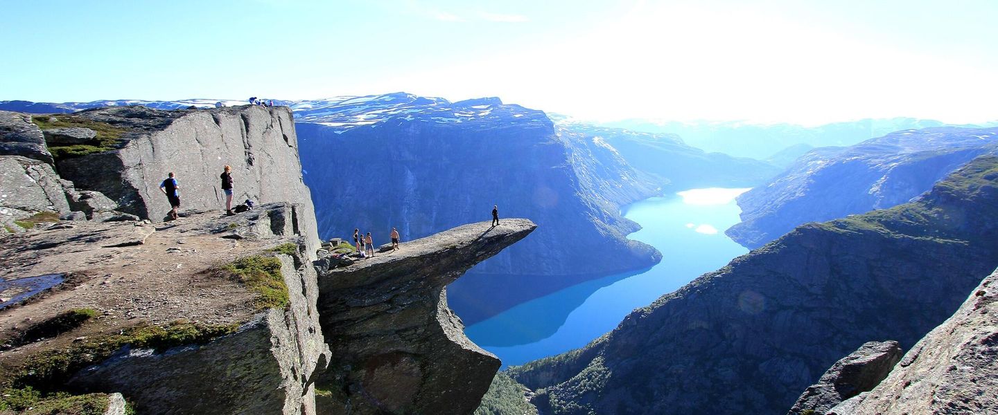


Hardangervidda National Park, Norway’s vast mountain plateau, offers wild reindeer, remote hiking, glacial landscapes and scenic gateway towns.
A Plateau of Mountain, Ice and Open Sky
Hardangervidda National Park occupies a broad high plateau in southern Norway, stretching across parts of Vestland, Telemark and Buskerud. Established in 1981, it is Norway’s largest national park and protects one of Northern Europe’s most extensive high mountain landscapes. Much of the plateau lies above the tree line, where rounded mountains, stony ridges, snow patches, lakes and wide valleys create a spacious, weather-exposed environment. The terrain is less sharply alpine than the neighbouring mountains around Jotunheimen, but its scale and remoteness make it equally compelling.Read more about Hardangervidda National Park
Wild Reindeer and Cultural Landscapes
Ways into the National Park
When is the best time to visit Hardangervidda National Park?
Best: June–August · 15–18°C| Month | High (°C) | Rainfall (mm) |
|---|---|---|
| January | -2 | 40 |
| February | 0 | 35 |
| March | 2 | 40 |
| April | 5 | 45 |
| May | 10 | 50 |
| June (best) | 15 | 55 |
| July (best) | 18 | 60 |
| August (best) | 16 | 60 |
| September | 12 | 55 |
| October | 7 | 50 |
| November | 3 | 45 |
| December | 1 | 40 |
Getting to and around Hardangervidda National Park
How to get there
Transportation
Best attractions in Hardangervidda National Park
Hardangervidda’s principal attraction is the plateau itself, a vast succession of open uplands, lakes, valleys and rounded mountains that can be explored on marked walking routes and longer hut-to-hut journeys. The western edge around Eidfjord leads towards the dramatic Måbødalen valley and Vøringsfossen, a major waterfall outside the national park boundary but closely associated with access to the plateau. Northern gateways such as Haugastøl, Ustaoset and Geilo provide routes into high mountain terrain, while the eastern side around Møsvatn and Rjukan offers different perspectives over the uplands. The interior is valued for space, silence and the possibility of seeing wild reindeer rather than for a dense concentration of built attractions. Lakes, mountain shelters, old travel routes and archaeological traces add cultural interest, while seasonal snow and changing light give the plateau a markedly different character through the year.
-
Scenic spot
Trolltunga "Troll's Tongue"
Experience the breathtaking views from Trolltunga, Norway's iconic cliff offering adventure, stunning scenery, and unforgettable memories.
-
Mountain peak
Trolltunga
Explore the breathtaking beauty of Trolltunga, Norway's iconic mountain peak with stunning views and thrilling hiking trails.
-
Tourist attraction
Skaupsjøen/Hardangerjøkulen landskapsvernområde
Explore the natural wonders of Skaupsjøen and Hardangerjøkulen, a breathtaking landscape protection area perfect for outdoor adventures and scenic views.
-
Tourist attraction
Prestholtseter
Discover Prestholtseter: A breathtaking tourist attraction in Norway's Hardangervidda, perfect for hiking and immersing yourself in nature's beauty.


Best landmarks in Hardangervidda National Park
The defining landmark of Hardangervidda is its immense elevated plateau, whose open horizons, glacial lakes and rounded summits create a landscape distinct from Norway’s sharper alpine ranges. Vøringsfossen, in the Måbødalen valley outside the national park, is one of the best-known natural attractions associated with the western approach, while the valleys descending towards Eidfjord show the dramatic contrast between high plateau and fjord country. Møsvatn and the mountain country near Rjukan form important eastern reference points, and the Bergen Railway marks the northern edge with stations that have become gateways for mountain travel. Old routes, hunting structures and trapping pits are significant cultural landmarks because they record long-standing human use of the plateau. Mountain lodges and seasonal farm landscapes around the margins further illustrate how travel, grazing and outdoor life have been organised in this high, exposed environment.
-
Tourist attraction
Vøringsfossen
Experience the breathtaking beauty of Vøringsfossen, Norway's iconic waterfall plunging into the stunning Måbødalen valley.
-
Visitor center
Norsk Natursenter Hardanger
Explore the breathtaking beauty and geography of Norway at Norsk Natursenter Hardanger, a captivating visitor center in Øvre Eidfjord.
-
Scenic spot
Skaupsjøen/Hardangerjøkulen landskapsvernområde
Explore the breathtaking Skaupsjøen and Hardangerjøkulen Landscape Conservation Area, a scenic paradise for nature lovers and adventure seekers in Norway.
-
Visitor center
Hardangervidda National Park Center
Explore Hardangervidda National Park Center, a gateway to Norway's stunning landscapes, wildlife, and cultural heritage, with delicious local treats.


Explore Hardangervidda National Park on the map
Plan your trip on one map. See where the top attractions, landmarks, restaurants and hotels are, and book hotels and experiences in a few clicks.
Best hotels in Hardangervidda National Park
Best restaurants in Hardangervidda National Park
There are no restaurant districts within Hardangervidda National Park, and visitors travelling into the interior must plan food around their route, packed provisions and the facilities of any mountain lodge used. Dining is concentrated in gateway settlements such as Geilo, Eidfjord, Rjukan, Rauland, Haugastøl and the wider Hardanger communities, where hotels, cafés, shops and restaurants serve travellers heading into the mountains. Regional Norwegian cooking commonly draws on lamb, dairy produce, potatoes, berries, freshwater fish and, around the fjord country, locally produced fruit. In the Hardanger area, apple-growing and cider production are important parts of the regional food identity. Mountain lodges may offer simple meals to guests under their own arrangements, but services, opening periods and booking requirements vary, so independent walkers should never assume that food can be purchased at every stage of a crossing.
-
Indoor lodging
Dyranut Fjellstova
Experience authentic Norwegian hospitality at Dyranut Fjellstova - where traditional cuisine meets stunning natural beauty in Eidfjord.
-
Restaurant
Halne Fjellstugu
Experience authentic Norwegian cuisine at Halne Fjellstugu while soaking in breathtaking views of Vøringsfoss's stunning landscapes.
-
Restaurant
Glacier Restaurant, Bar & Cafe
Discover Glacier Restaurant: A culinary gem in Odda offering diverse European and global dishes alongside vegan and gluten-free options.
-
Restaurant
KOMPAEN - Bistro og Deli
Experience authentic Norwegian flavors at KOMPAEN - Bistro og Deli in Lofthus, where every meal is crafted with care and local ingredients.


Best bars in Hardangervidda National Park
Hardangervidda itself has no conventional nightlife, and evenings in the interior are shaped by mountain weather, lodge routines, quiet trails and the changing light over the plateau. Traditional pubs, hotel bars and après-hike hospitality are more likely in gateway settlements such as Geilo, Rjukan and Eidfjord, with a modest seasonal social scene rather than a concentrated club district. Mountain lodges can provide a communal evening atmosphere for overnight walkers, although their facilities and operating periods differ. Visitors staying near the Hardanger fjords may find local restaurants and hotel bars, while larger towns outside the destination offer a broader choice of entertainment. Events and live performances should be checked locally, as availability is seasonal and cannot be assumed across this spacious rural region.
-
Indoor lodging
Dyranut Fjellstova
Discover the charm of Dyranut Fjellstova, where traditional Norwegian hospitality meets stunning landscapes for an unforgettable getaway.
-
Restaurant
Halne Fjellstugu
Experience authentic Norwegian cuisine at Halne Fjellstugu, nestled in the stunning landscapes of Vøringsfoss, perfect for every food lover.
-
Bar
Glacier Restaurant, Bar & Cafe
Experience a delightful fusion of European, Middle Eastern, and Indian cuisines at Glacier Restaurant, Bar & Café in scenic Odda.
-
Restaurant
Hardangerviddahallen
Experience authentic Norwegian cuisine with breathtaking views at Hardangerviddahallen in Øvre Eidfjord.


Best nightclubs in Hardangervidda National Park
Hardangervidda itself has no conventional nightlife, and evenings in the interior are shaped by mountain weather, lodge routines, quiet trails and the changing light over the plateau. Traditional pubs, hotel bars and après-hike hospitality are more likely in gateway settlements such as Geilo, Rjukan and Eidfjord, with a modest seasonal social scene rather than a concentrated club district. Mountain lodges can provide a communal evening atmosphere for overnight walkers, although their facilities and operating periods differ. Visitors staying near the Hardanger fjords may find local restaurants and hotel bars, while larger towns outside the destination offer a broader choice of entertainment. Events and live performances should be checked locally, as availability is seasonal and cannot be assumed across this spacious rural region.
-
National park
Hardangervidda National Park
Discover the breathtaking landscapes and rich wildlife of Hardangervidda National Park, Norway's largest national park, perfect for outdoor adventures.
-
Restaurant
Halne Fjellstugu
Experience the flavors of Norway at Halne Fjellstugu, where culinary excellence meets breathtaking mountain views.
-
Plateau
Hardangervidda
Discover the stunning beauty of Hardangervidda, Norway's largest mountain plateau, perfect for hiking, fishing, and reconnecting with nature.
-
Mountain cabin
Sandhaug
Discover the tranquility of Sandhaug, a mountain cabin retreat in the breathtaking Hardangervidda region of Norway, perfect for nature lovers and adventurers.


Best shops in Hardangervidda National Park
Shopping within Hardangervidda National Park is extremely limited, with no extensive retail centre in the protected interior. Practical supplies, maps, clothing and outdoor equipment are more readily obtained in gateway towns such as Geilo, Eidfjord and Rjukan, while smaller settlements around the plateau provide a more limited range of everyday goods. The surrounding Hardanger region is known for local fruit, apple products and cider, and farm shops or producers may offer these regional goods in season. Other appropriate purchases include Norwegian woollen items, locally made handicrafts, food products and souvenirs connected with mountain culture, although availability varies by settlement and season. Travellers planning a remote walk should buy fuel, food and essential equipment before leaving the larger gateways rather than relying on incidental shopping near trailheads or mountain lodges.
-
National park
Hardangervidda National Park
Explore the breathtaking landscapes and rich wildlife of Hardangervidda National Park, Norway's largest national park and a haven for outdoor enthusiasts.
-
Visitor center
Norsk Natursenter Hardanger
Experience the beauty of Norway's nature at Norsk Natursenter Hardanger, where education meets stunning landscapes and delicious local cuisine.
-
Indoor lodging
Dyranut Fjellstova
Experience the warmth of traditional Norwegian hospitality at Dyranut Fjellstova, where stunning landscapes meet authentic local cuisine.
-
Scenic spot
Skaupsjøen/Hardangerjøkulen landskapsvernområde
Explore the Skaupsjøen/Hardangerjøkulen Landscape Reserve: A breathtaking blend of lakes, glaciers, and hiking trails in Norway's stunning wilderness.


Get your free copy of our complete guide to Hardangervidda National Park, delivered straight to you.
Everything on this page, from attractions and restaurants to essentials and local phrases, in one PDF you can read offline, print or share.
Already have an account? Sign in
Your Hardangervidda National Park guide is ready.
We'll send it to · Not you? Sign out

Getting your guide ready…
We are putting together a fresh copy of the Hardangervidda National Park guide. This can take up to a minute.
This can take a few moments. If your browser asks, choose Allow so the download can start. You'll find the guide in your Downloads folder.
Nothing happened? Download it again
Sorry, the guide is taking longer than usual. Please try again in a minute, or get it by email instead.
Hardangervidda National Park essentials
Currency and Payment
Safety
Emergency Situations
Do's and Don'ts
Local Tips
From Eve
Local phrases worth knowing
You don't need to get them perfect. A few words go a long way, and locals appreciate the effort.
Basics
| English | Local | Say it |
|---|---|---|
| Hello | Hei | [hay] |
| Goodbye | Ha det | [ha deh] |
| Yes | Ja | [yah] |
| No | Nei | [nay] |
| Please/You're welcome | Vær så god | [vair soh goh] |
| Thank you | Takk | [tahk] |
| Excuse me/Sorry | Unnskyld | [oon-skuld] |
| How are you? | Hvordan har du det? | [vohr-dan har doo deh] |
| Fine. And you? | Bra. Og du? | [bra oh doo] |
| Do you speak English? | Snakker du engelsk? | [snah-ker doo eng-elsk] |
| I don't understand | Jeg forstår ikke | [yay for-stor eek-keh] |
Eating & Drinking
| English | Local | Say it |
|---|---|---|
| I'd like to see the menu, please | Kan jeg få se menyen, takk | [kahn yai foh seh meh-nyen tahk] |
| I don't eat meat | Jeg spiser ikke kjøtt | [yay spee-ser eek-keh shut] |
| Cheers! | Skål! | [skohl] |
| I would like to pay, please | Jeg vil gjerne betale, takk | [yay veal yair-neh bet-ah-leh tahk] |
Emergencies
| English | Local | Say it |
|---|---|---|
| Help! | Hjelp! | [yelp] |
| Go away! | Gå vekk! | [goh vehk] |
| Call the Police! | Ring politiet! | [ring poh-lee-tee-eh] |
| Call a doctor! | Ring en lege! | [ring en leh-geh] |
| I'm lost | Jeg er tapt | [yay air tahpt] |
| I'm ill | Jeg er syk | [yay air sook] |
Shopping
| English | Local | Say it |
|---|---|---|
| I'd like to buy... | Jeg vil kjøpe... | [yay veal shoop-eh] |
| I'm just looking | Jeg bare ser | [yay bah-reh sair] |
| How much is it? | Hvor mye koster det? | [vor mee-eh kus-teh deh] |
| That's too expensive | Det er for dyrt | [deh air for deert] |
| Can you lower the price? | Kan du senke prisen? | [kahn doo sen-keh pree-sen] |
Time & Numbers
| English | Local | Say it |
|---|---|---|
| What time is it? | Hva er klokka? | [vah air klok-ah] |
| It's one o'clock | Klokka er ett | [klok-ah air et] |
| Half past (10) | Halv ti | [halv tee] |
| Morning | Morgen | [mohr-gen] |
| Afternoon | Ettermiddag | [et-ter-mee-dahg] |
| Evening | Kveld | [kvehld] |
| Yesterday | I går | [ee gohr] |
| Today | I dag | [ee dahg] |
| Tomorrow | I morgen | [ee mohr-gen] |
| 1 | En | [ehn] |
| 2 | To | [too] |
| 3 | Tre | [tray] |
| 4 | Fire | [fee-reh] |
| 5 | Fem | [fem] |
| 6 | Seks | [sehks] |
| 7 | Syv | [soov] |
| 8 | Åtte | [oht-teh] |
| 9 | Ni | [nee] |
| 10 | Ti | [tee] |
Transport & Directions
| English | Local | Say it |
|---|---|---|
| Where's a/the...? | Hvor er en/et...? | [vor air en/et] |
| What's the address? | Hva er adressen? | [vah air ah-dress-en] |
| Can you show me (on the map)? | Kan du vise meg (på kartet)? | [kahn doo vee-seh may (poh kart-eh)] |
| When's the next (bus)? | Når går neste (buss)? | [nahr gohr nes-teh (boos)] |
| A ticket (to ....) | En billett (til ....) | [ehn bee-leht (teel)] |
History of Hardangervidda National Park
An Ancient Mountain Plateau
Hardangervidda’s rounded uplands were shaped over immense geological timescales and later remodelled by repeated glaciations. Ice movement carved valleys, basins and countless lakes, while weathering and erosion produced the broad, elevated plateau seen today. Unlike Norway’s sharper coastal mountains, much of Hardangervidda consists of open uplands with gently contoured summits, though deeper valleys mark its edges. The retreat of the last major ice sheets left a landscape of exposed rock, thin soils and wetlands that continues to be influenced by snow, frost and seasonal meltwater.
Early Hunting and Seasonal Travel
People have used Hardangervidda since the Stone Age, following wild reindeer and exploiting the plateau’s fish, plants and natural routes. Archaeological evidence includes ancient hunting systems, trapping pits and other traces of repeated seasonal activity. Reindeer were not only a source of food and materials but also influenced the routes used to cross the mountains. These remains demonstrate that the plateau’s apparent remoteness has long been connected to human movement, with travel shaped by weather, snow conditions and the annual patterns of wildlife.
Farms, Pastures and Mountain Routes
Communities around Hardangervidda developed a mixed relationship with the uplands. Mountain farms used summer pastures, lakes supported fishing, and routes across the plateau linked settlements on the western fjords with valleys and communities to the east. Seasonal movement between lowland farms and mountain grazing areas helped shape traditions of pastoral land use. The plateau was never densely settled, but its margins contain a network of farmsteads, valleys and villages whose livelihoods were historically tied to livestock, fishing, hunting and the difficult work of crossing high ground.
Exploration and the Rise of Tourism
Improved roads, railways and mountain routes gradually made Hardangervidda more accessible to travellers. The railway between Oslo and Bergen, opened in stages during the early twentieth century, created important northern gateways at places including Haugastøl, Ustaoset and Finse, while roads around the plateau connected western and eastern valleys. Walking tourism developed alongside Norway’s wider culture of mountain travel, with marked routes and mountain lodges making longer crossings more practical. Even so, the interior retained a strong sense of distance and exposure.
Protection and Modern Conservation
Hardangervidda National Park was established in 1981 to protect the plateau’s landscapes, wildlife and cultural remains. Conservation has particular importance for the wild reindeer population, whose movements can be affected by roads, development, recreation and other barriers around the mountain region. Management therefore balances public access with the protection of habitats, archaeological sites and migration areas. Today, hiking, fishing and other outdoor activities remain central to the area’s identity, but they take place within a landscape where ecological pressures and changing climate conditions require careful stewardship.
Hardangervidda National Park in Photos
Browse through our photo collection highlighting the charm and character of the destination.
Neighbouring destination travel guides
The closest destinations to Hardangervidda National Park, if you have time for more than one.
-

-
-

-
-


Swipe for more destinations
Explore more

Explore more of Hordaland
Discover Hordaland: Norway's enchanting region of fjords, mountains, and cultural treasures, where nature and tradition meet in perfect harmony.
Explore Hordaland
Explore more of Norway
Explore Norway's spectacular fjords, vibrant cities, and natural wonders. Experience the Northern Lights, Midnight Sun, and rich cultural heritage in this Scandinavian gem.
Explore Norway