

Mount Wilhelm Travel Guide - Free Web & App
Your ultimate guide to Mount Wilhelm. Discover top landmarks, proposed trips, and local tips. Free on the web or via the Evendo companion app.


Mount Wilhelm, Papua New Guinea’s highest peak, offers challenging alpine trekking, highland culture, cold mountain lakes and Bismarck Range views.
Highland Geography
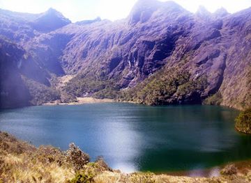
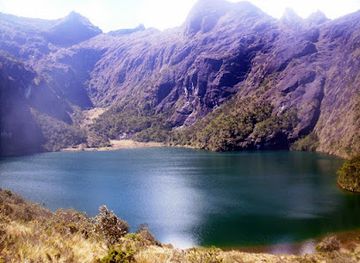
Mount Wilhelm rises to 4,509 metres in the Bismarck Range of central Papua New Guinea, making it the country’s highest mountain. It lies in a remote highland landscape of grasslands, montane forest, rocky slopes and cold, thin air, far from the tropical coastlines with which Papua New Guinea is often associated. The usual approach begins near Keglsugl, a rural settlement reached from Kundiawa in Chimbu Province, before climbing towards the alpine lakes of Piunde and Aunde and the summit ridge.Read more about Mount Wilhelm
The Mountain Experience
People and Access
When is the best time to visit Mount Wilhelm?
Best: May–July · 11°C| Month | High (°C) | Rainfall (mm) |
|---|---|---|
| January | 12 | 325 |
| February | 11 | 290 |
| March | 11 | 269 |
| April | 11 | 256 |
| May (best) | 11 | 251 |
| June (best) | 11 | 251 |
| July (best) | 11 | 254 |
| August | 11 | 260 |
| September | 11 | 269 |
| October | 11 | 280 |
| November | 11 | 297 |
| December | 12 | 312 |
Getting to and around Mount Wilhelm
How to get there
Transportation
Best attractions in Mount Wilhelm
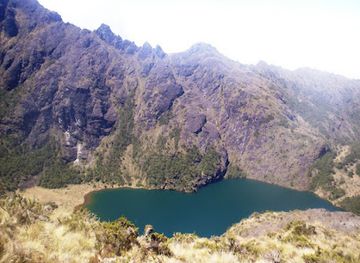
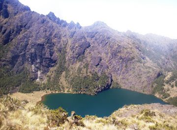
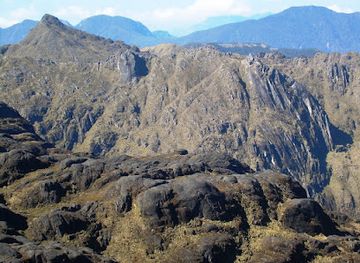
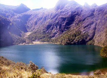
The principal attraction is the ascent of Mount Wilhelm itself, a demanding route through the highlands towards the alpine lakes of Piunde and Aunde and the rocky summit ridge at 4,509 metres. The walk offers changing environments, from cultivated valleys and montane forest to cold grassland, boulder fields and exposed high-altitude terrain. The lakes provide a memorable staging point and reflect the mountain’s rugged upper landscape, while clear conditions can open views across the Bismarck Range and neighbouring valleys. Keglsugl is an attraction in its own right as the rural gateway where visitors encounter highland gardens, local communities and the practical realities of mountain travel. Kundiawa, lower in the Chimbu landscape, is the principal service and cultural base for arranging transport, guides and supplies. The appeal lies in the connected experience of villages, upland scenery and strenuous walking rather than in a concentration of formal visitor facilities.
-
Mountain peak
Mt Wilhelm
Explore the breathtaking heights of Mt Wilhelm, the highest peak in Papua New Guinea, where adventure meets stunning natural beauty in Madang Province.
Best landmarks in Mount Wilhelm
Mount Wilhelm is the defining natural landmark, rising to 4,509 metres above the central highlands and forming part of the Bismarck Range. Its summit ridge marks the culmination of the standard trekking route, while the high-altitude lakes of Piunde and Aunde are prominent landscape features on the approach. The transition from cultivated valleys and montane forest to open alpine terrain gives the mountain its strongest geographical character. Keglsugl is the principal human landmark of the route, representing the community gateway through which visitors reach the upper mountain. The wider Bismarck Range is also significant as a highland system with contrasting climates, habitats and valleys. Mount Wilhelm’s name reflects German colonial history, but the surrounding paths, gardens and customary lands connect the landmark to much older local relationships with the mountain environment.
-
Mountain peak
Mt Wilhelm
Explore Mt Wilhelm, the highest peak in Papua New Guinea, and immerse yourself in breathtaking views, rich biodiversity, and cultural heritage.
Explore Mount Wilhelm on the map
Plan your trip on one map. See where the top attractions, landmarks, restaurants and hotels are, and book hotels and experiences in a few clicks.
Best hotels in Mount Wilhelm
Best restaurants in Mount Wilhelm
Dining facilities on Mount Wilhelm are extremely limited, with food generally arranged through accommodation providers, trekking organisers or personal provisions rather than independent restaurants on the mountain. In Keglsugl, visitors may encounter simple community-based meals or locally organised hospitality, but arrangements should be confirmed in advance. Kundiawa provides a broader choice of everyday eateries and shops, although the range remains modest compared with Papua New Guinea’s main cities. Highland cooking commonly draws on garden produce such as sweet potato, greens, taro and other vegetables, while pork and chicken may appear at community meals or celebrations. Travellers should carry suitable trekking food and ask guides about safe water and resupply options before leaving town. The most meaningful food experiences are often connected with local homes, gardens and community hospitality, where respectful advance arrangements matter more than a formal dining scene.
-
Mountain peak
Mt Wilhelm
Experience breathtaking views and challenging hikes at Mt Wilhelm - Papua New Guinea's highest peak offering a paradise for outdoor enthusiasts.
Best bars in Mount Wilhelm
Mount Wilhelm has no established nightlife district, nightclub scene or concentration of late-opening bars. Evenings around Keglsugl are quiet and shaped by rural community life, early starts, mountain weather and the practical demands of trekking. Visitors staying in local accommodation may share a simple meal or conversation with hosts, subject to local customs and arrangements, while Kundiawa offers the area’s more developed selection of ordinary drinking and social venues. These should be approached as local establishments rather than tourist entertainment facilities, and visitors should dress and behave respectfully. Alcohol is not appropriate before a strenuous ascent, and the isolated mountain route has no evening entertainment infrastructure. After dark, torches, warm clothing and attention to accommodation security are more useful than plans for nightlife.
-
Mountain peak
Mt Wilhelm
Discover the breathtaking beauty of Mt Wilhelm, the highest peak in Papua New Guinea, offering stunning views and an unforgettable hiking adventure.
Best nightclubs in Mount Wilhelm
Mount Wilhelm has no established nightlife district, nightclub scene or concentration of late-opening bars. Evenings around Keglsugl are quiet and shaped by rural community life, early starts, mountain weather and the practical demands of trekking. Visitors staying in local accommodation may share a simple meal or conversation with hosts, subject to local customs and arrangements, while Kundiawa offers the area’s more developed selection of ordinary drinking and social venues. These should be approached as local establishments rather than tourist entertainment facilities, and visitors should dress and behave respectfully. Alcohol is not appropriate before a strenuous ascent, and the isolated mountain route has no evening entertainment infrastructure. After dark, torches, warm clothing and attention to accommodation security are more useful than plans for nightlife.
-
Mountain peak
Mt Wilhelm
Experience the breathtaking heights of Mt. Wilhelm, Papua New Guinea's tallest peak, where adventure meets stunning natural beauty.
Best shops in Mount Wilhelm
Shopping opportunities are concentrated in Kundiawa and are principally practical rather than specialist. Visitors can seek food, drinking water, basic trekking supplies and locally available produce there before travelling towards Keglsugl, where retail facilities are more limited. The mountain itself has no established shopping area, souvenir market or dependable equipment outlet. In highland communities, visitors may encounter locally produced garden food, woven items or handmade goods through personal and community contacts, but availability is not guaranteed and purchases should be made respectfully. Ask permission before photographing crafts or production, and avoid treating customary objects as commercial souvenirs without clear agreement. Anyone planning the trek should obtain specialist clothing, lighting, first-aid equipment and other technical necessities before reaching the rural gateway, since replacement supplies near the trailhead may be difficult to find.
-
Mountain peak
Mt Wilhelm
Discover the breathtaking beauty and thrilling adventures at Mt Wilhelm, Papua New Guinea's highest peak nestled in the stunning Madang Province.
Get your free copy of our complete guide to Mount Wilhelm, delivered straight to you.
Everything on this page, from attractions and restaurants to essentials and local phrases, in one PDF you can read offline, print or share.
Already have an account? Sign in
Your Mount Wilhelm guide is ready.
We'll send it to · Not you? Sign out

Getting your guide ready…
We are putting together a fresh copy of the Mount Wilhelm guide. This can take up to a minute.
This can take a few moments. If your browser asks, choose Allow so the download can start. You'll find the guide in your Downloads folder.
Nothing happened? Download it again
Sorry, the guide is taking longer than usual. Please try again in a minute, or get it by email instead.
Mount Wilhelm essentials
Currency and Payment
Safety
Emergency Situations
Do's and Don'ts
Local Tips
From Eve
Local phrases worth knowing
You don't need to get them perfect. A few words go a long way, and locals appreciate the effort.
Basics
| English | Local | Say it |
|---|---|---|
| Hello | Kapul | [Kah-pool] |
| Goodbye | Kapim gut | [Kah-peem goot] |
| Yes | Em | [Em] |
| No | Nogat | [No-gat] |
| Please/You're welcome | Plis | [Plees] |
| Thank you | Tenk yu | [Tank yoo] |
| Excuse me/Sorry | Sori | [So-ree] |
| How are you? | Yu stap gut? | [Yoo stap goot?] |
| Fine. And you? | Gut tasol. Na yu? | [Goot tah-sol. Nah yoo?] |
| Do you speak English? | Yu save long tok Inglis? | [Yoo sah-veh long toke In-glees?] |
| I don't understand | Mi nogat save | [Mee no-gat sah-veh] |
Eating & Drinking
| English | Local | Say it |
|---|---|---|
| I'd like to see the menu, please | Mi laik lukim menu, plis | [Mee like look-eem men-oo, plees] |
| I don't eat meat | Mi nogat kaikim kanda | [Mee no-gat kai-keem kan-dah] |
| Cheers! | Mipela lukim | [Mee-pay-lah look-eem] |
| I would like to pay, please | Mi laik bai, plis | [Mee like by, plees] |
Emergencies
| English | Local | Say it |
|---|---|---|
| Help! | Halivim mi! | [Ha-lee-veem mee!] |
| Go away! | Go long we! | [Go long way!] |
| Call the Police! | Kolim Polis! | [Ko-leem Po-lees!] |
| Call a doctor! | Kolim dokta! | [Ko-leem dok-tah!] |
| I'm lost | Mi les | [Mee less] |
| I'm ill | Mi sik | [Mee seek] |
Shopping
| English | Local | Say it |
|---|---|---|
| I'd like to buy... | Mi laik baim... | [Mee like bime...] |
| I'm just looking | Mi tasol lukim | [Mee tah-sol look-eem] |
| How much is it? | Em inap long hamamas? | [Em ee-nap long ha-ma-mas?] |
| That's too expensive | Em i planti tumas | [Em ee plan-tee too-mas] |
| Can you lower the price? | Yu ken lusim pris? | [Yoo ken loo-seem prees?] |
Time & Numbers
| English | Local | Say it |
|---|---|---|
| What time is it? | Em i wanem taim? | [Em ee wah-nem tah-eem?] |
| It's one o'clock | Em i wan taim | [Em ee wah-nah tah-eem] |
| Half past (10) | Haus past tupela | [Haus past too-pay-lah] |
| Morning | Moning | [Moh-ning] |
| Afternoon | Apinun | [Ah-pee-noon] |
| Evening | Evening | [Eh-veh-ning] |
| Yesterday | Isterde | [Is-ter-day] |
| Today | Tude | [Too-day] |
| Tomorrow | Tumora | [Too-mor-ah] |
| 1 | Wan | [Wahn] |
| 2 | Tu | [Too] |
| 3 | Tri | [Tree] |
| 4 | Fo | [Foh] |
| 5 | Faiv | [Fah-eve] |
| 6 | Sikis | [Sick-iss] |
| 7 | Seven | [Sev-en] |
| 8 | Eit | [Ate] |
| 9 | Nain | [Nah-een] |
| 10 | Ten | [Ten] |
Transport & Directions
| English | Local | Say it |
|---|---|---|
| Where's a/the...? | Wanem ples... | [Wah-nem plehs...] |
| What's the address? | Em i wanem adras? | [Em ee wah-nem ad-ras?] |
| Can you show me (on the map)? | Yu ken soim mi? | [Yoo ken soy-mee mee?] |
| When's the next (bus)? | Wanem taim nabin (bus)? | [Wah-nem tah-eem nah-been (bus)?] |
| A ticket (to ....) | Wan tiket (long ....) | [Wah-n tee-ket (long ....)] |
History of Mount Wilhelm
An Ancient Mountain Landscape
Mount Wilhelm belongs to the Bismarck Range, a high mountain system formed through the geological processes that shaped the central spine of New Guinea. Its upper slopes, alpine lakes and montane environments are the product of long-term uplift, erosion and climatic change rather than human construction. The sharp contrast between humid lower valleys and cold, exposed summit terrain helps explain the ecological variety found within a relatively compact area. The lakes near the climbing route, including Piunde and Aunde, are important features of the mountain’s high-altitude landscape and have long formed part of the environment known to communities living around Keglsugl.
Communities of the Bismarck Highlands
The mountain is situated within a densely inhabited highland region where communities have developed agricultural systems suited to steep valleys, cool temperatures and fertile volcanic soils. Gardens, paths and customary land relationships shape the approach to Mount Wilhelm, and the mountain is not an empty wilderness separated from local life. The Keglsugl area provides the most familiar cultural and practical gateway for trekkers. Local knowledge remains important for understanding routes, weather, land access and the changing conditions of the upper mountain, while traditional community structures continue to influence how visitors are received and assisted.
German Colonial Naming
The name Mount Wilhelm dates from the period of German colonial rule in north-eastern New Guinea, when several features in the Bismarck Range were named after members of the German imperial family. The mountain was named for Wilhelm II, the German emperor. Although the colonial name remains widely used, the surrounding landscape has a much longer history belonging to the highland communities who lived with and travelled through these mountains. This distinction is important: the modern name reflects a short colonial period, whereas the mountain’s cultural and environmental significance extends across generations of local knowledge.
Exploration and the First Ascent
European exploration of the central highlands increased during the twentieth century, bringing government patrols, mapping and later scientific interest to areas that had previously been difficult for outsiders to reach. Mount Wilhelm was first climbed in 1938 by Australian patrol officer Leigh Vial with local guides, an achievement associated with the expanding colonial administration and its use of highland routes. The ascent also demonstrated the demanding conditions of the summit environment. Today, the same broad route is followed by trekkers, although the journey remains dependent on local support, weather and the physical condition of the mountain path.
From Colonial Territory to Trekking Destination
Papua New Guinea became independent in 1975, and Mount Wilhelm subsequently developed as one of the country’s best-known highland trekking objectives. Its reputation rests on altitude, scenery and the challenge of reaching the summit rather than on extensive visitor infrastructure. Trekking has created opportunities for local guides, porters and accommodation providers around Keglsugl and Kundiawa, while also making responsible access increasingly important. Conservation concerns include erosion, waste, disturbance to fragile upland habitats and the need to respect customary land. Conditions and facilities can change, so current local advice remains essential.
Mount Wilhelm in Photos
Browse through our photo collection highlighting the charm and character of the destination.
Neighbouring destination travel guides
The closest destinations to Mount Wilhelm, if you have time for more than one.
-

-

-

-

-


Swipe for more destinations
Explore more

Explore more of Chimbu Region
Explore the Chimbu Region: Discover Papua New Guinea's Highlands with its towering peaks, rich traditions, and breathtaking landscapes.
Explore Chimbu Region
Explore more of Papua New Guinea
Discover Papua New Guinea, where ancient cultures meet untamed wilderness. From vibrant festivals to stunning natural landscapes, an adventure awaits in this Pacific gem.
Explore Papua New Guinea