

Alpamayo Circuit Travel Guide - Free Web & App
Your ultimate guide to Alpamayo Circuit. Discover top landmarks, proposed trips, and local tips. Free on the web or via the Evendo companion app.


Alpamayo Circuit, Peru: trek through Cordillera Blanca valleys, high passes, Quechua villages and views of Alpamayo in Huascarán National Park.
A High-Andean Wilderness
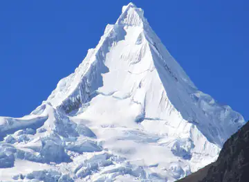
The Alpamayo Circuit is a demanding multi-day trek through Peru’s Cordillera Blanca, the glaciated mountain range east of Huaraz in the Ancash region. Rather than being a single tightly defined path, the circuit is a network of high-altitude trails linking remote Quechua-speaking communities, pasture valleys and mountain passes around Alpamayo, one of the Cordillera Blanca’s most recognisable pyramidal peaks. Routes commonly approach the circuit from valleys such as Santa Cruz, Cashapampa or Hualcayan, with exact itineraries varying according to weather, acclimatisation, local access and the condition of high passes.Read more about Alpamayo Circuit
Valleys, Passes and Glacial Peaks
Communities and Trekking Character
When is the best time to visit Alpamayo Circuit?
Best: January, March, November · 15°C| Month | High (°C) |
|---|---|
| January (best) | 15 |
| February | 14 |
| March (best) | 15 |
| April | 14 |
| May | 13 |
| June | 12 |
| July | 11 |
| August | 12 |
| September | 13 |
| October | 14 |
| November (best) | 15 |
| December | 15 |
Getting to and around Alpamayo Circuit
How to get there
Transportation
Best attractions in Alpamayo Circuit
The main attraction of the Alpamayo Circuit is the succession of remote Cordillera Blanca landscapes rather than a single developed visitor site. Trekkers pass through high valleys, puna grasslands, glacial cirques and austere passes, with Alpamayo appearing from changing angles as the route winds around its massif. Depending on the chosen variant, approaches may use the Santa Cruz or Hualcayan and Cashapampa valleys, each providing a different introduction to the mountain environment. Turquoise glacial lakes, moraine slopes and neighbouring snow peaks form the circuit’s visual highlights, while small Quechua settlements and grazing areas reveal the continuing human use of the valleys. The route is also associated with Huascarán National Park, whose protected landscapes support high-Andean habitats and important water systems. There are few conventional attractions, museums or permanent facilities along the trail, so the experience depends on walking between camps, observing changing geology and weather, and appreciating the relationship between mountain ecosystems and surrounding communities.
-
Mountain peak
Alpamayo
Discover the breathtaking beauty of Alpamayo, one of the world's most stunning mountain peaks in the heart of the Peruvian Andes.
-
Glacier
Nevado Alpamayo
Explore the breathtaking beauty of Nevado Alpamayo, a stunning glacial peak in the Peruvian Andes, offering adventure and cultural richness.
-
Hiking area
Trek Santa Cruz
Experience the breathtaking beauty and adventure of Trek Santa Cruz, a premier hiking destination in the heart of Peru's Andes mountains.
-
Hiking area
Laguna Cullicocha
Experience the serene beauty of Laguna Cullicocha, a stunning hiking destination in Hualcallán, Peru, surrounded by majestic mountains and lush nature.


Best landmarks in Alpamayo Circuit
Alpamayo is the circuit’s defining natural landmark, recognised for its sharply pyramidal, ice-clad profile and its place among the Cordillera Blanca’s celebrated climbing peaks. The surrounding high passes, glacial valleys, moraine walls and mountain lakes are landmarks in their own right, recording the interaction between uplift, erosion and glacial movement. Several route variants also draw on the contrasting valley approaches through Santa Cruz, Cashapampa and Hualcayan, although their exact inclusion depends on itinerary and current access. Huascarán National Park provides the wider protected setting, linking the mountains to high-Andean grasslands, wildlife habitat and downstream water systems. The circuit has few constructed monuments; its cultural landmarks are the Quechua settlements, farming landscapes, footpaths and communal spaces that connect the high mountains with the inhabited valleys below.
-
Mountain peak
Alpamayo
Discover the breathtaking beauty of Alpamayo, one of the world's most stunning mountain peaks, nestled in the majestic Andes of Peru.
-
Travel agency
Peruvian Mountains Trek Climb
Discover breathtaking treks and rich culture in the Peruvian Andes with guided adventures from the Peruvian Mountains Trek Climb.
-
Glacier
Nevado Alpamayo
Discover the breathtaking beauty of Nevado Alpamayo, a stunning glacier in the heart of the Peruvian Andes, perfect for adventure seekers and nature lovers.


Explore Alpamayo Circuit on the map
Plan your trip on one map. See where the top attractions, landmarks, restaurants and hotels are, and book hotels and experiences in a few clicks.
Best hotels in Alpamayo Circuit
Best restaurants in Alpamayo Circuit
Dining opportunities are concentrated in Huaraz, Caraz and other gateway settlements rather than on the Alpamayo Circuit itself. In Huaraz, visitors can find restaurants and markets serving the food traditions of Ancash and the wider Peruvian Andes, including hearty soups, potatoes, maize, quinoa and dishes prepared with locally available meats and vegetables. Caraz and villages on the approach routes provide simpler eateries and small shops, although opening arrangements and supplies can be limited. Trekkers normally rely on provisions organised by a guide or trekking agency, with meals cooked at camp rather than purchased along the trail. Regional produce from valley farms and small-scale dairy and agricultural activity may appear in local markets, but visitors should not assume that remote communities have cafés, restaurants or regular food services.
-
Restaurant
Don Cuy
Experience the essence of Peru at Don Cuy in Huaraz – where authentic flavors meet exceptional service.
-
Restaurant
Cafe Andino
Discover the rich flavors of Peru at Cafe Andino in Huaraz – where exceptional coffee meets traditional cuisine.
-
Restaurant
ALPAMAYO CASA HOTEL - RESTAURANTE
Discover authentic Peruvian cuisine at Alpamayo Casa Hotel - Restaurante in Yungay, where comfort meets breathtaking mountain views.
-
Restaurant
Chilli Heaven
Discover the vibrant flavors of India at Chilli Heaven, an unmissable restaurant nestled in the beautiful city of Huaraz, Peru.


Best bars in Alpamayo Circuit
The Alpamayo Circuit has no nightlife infrastructure, and evenings are shaped by cold temperatures, early starts and the quiet of remote mountain camps. In Huaraz, the principal base for the trek, visitors can find a modest selection of pubs, bars and casual evening venues associated with the town’s trekking and mountaineering community, while Caraz offers a smaller local evening scene. In villages along the approach roads, entertainment is generally limited to community life and occasional local celebrations rather than dedicated visitor venues. Any festival, music event or public gathering depends on the calendar and should not be assumed to be taking place. On the circuit itself, responsible evenings mean keeping noise low, respecting nearby households and camps, and protecting the stillness of the high valleys.
-
Restaurant
Cafe Andino
Explore the authentic flavors of Huaraz at Cafe Andino, where every meal is a celebration of local Peruvian cuisine and coffee delights.
-
Restaurant
ALPAMAYO CASA HOTEL - RESTAURANTE
Savor the Essence of Peruvian Cuisine at Alpamayo Casa Hotel - Restaurante in Yungay, a Culinary Haven Surrounded by Nature's Beauty.
-
Hotel
Cordillera Blanca Lodge
Discover the beauty and adventure of the Andes at Cordillera Blanca Lodge, your mountain retreat in Huaraz, Peru.
-
 Hotel
Hotel El Patio de Monterrey
Immerse yourself in Peruvian culture at Hotel El Patio de Monterrey, your perfect retreat for comfort and exploration.


Best nightclubs in Alpamayo Circuit
The Alpamayo Circuit has no nightlife infrastructure, and evenings are shaped by cold temperatures, early starts and the quiet of remote mountain camps. In Huaraz, the principal base for the trek, visitors can find a modest selection of pubs, bars and casual evening venues associated with the town’s trekking and mountaineering community, while Caraz offers a smaller local evening scene. In villages along the approach roads, entertainment is generally limited to community life and occasional local celebrations rather than dedicated visitor venues. Any festival, music event or public gathering depends on the calendar and should not be assumed to be taking place. On the circuit itself, responsible evenings mean keeping noise low, respecting nearby households and camps, and protecting the stillness of the high valleys.
-
Mountain peak
Alpamayo
Discover the breathtaking beauty of Alpamayo, one of the most stunning peaks in the Peruvian Andes, perfect for trekking and climbing enthusiasts.
-
Night club
Arawi Club
Experience the electric atmosphere of Arawi Club in Huaraz, where locals and tourists come together for unforgettable nights of dancing and celebration.


Best shops in Alpamayo Circuit
Shopping on the Alpamayo Circuit is limited to practical supplies and occasional purchases in gateway towns. Huaraz has the broadest range of trekking equipment, clothing, food provisions and locally made goods, while Caraz and smaller approach settlements offer more modest shops and markets. Visitors may find Andean textiles, woven goods, pottery, carved objects and regional foods, but the quality, origin and availability of products vary, so purchases are best made directly from identifiable local makers or established market traders. Fresh produce and provisions can be bought before the trek, whereas there are no dependable shops on the high route. Buying locally produced goods respectfully can support mountain communities, but visitors should avoid removing plants, archaeological material or natural objects from the protected landscape.
-
Sports equipment rental service
Andes Camping Mountain Shop
Explore the Andes with confidence—gear up at Andes Camping Mountain Shop, your one-stop shop for adventure equipment and travel services in Huaraz.
-
Mountain peak
Alpamayo
Discover the breathtaking beauty of Alpamayo, Peru's iconic mountain peak, and experience thrilling treks amidst stunning Andean landscapes.
-
Hotel
Hotel Alpamayo
Experience comfort and hospitality at Hotel Alpamayo, your gateway to the stunning landscapes of Huaraz, Peru.
-
Travel agency
ALPAMAYO TRAVEL PERU (operador turístico & trekking tours))
Discover the beauty of the Andes with Alpamayo Travel Peru – your trusted partner for trekking tours and unforgettable adventures.


Get your free copy of our complete guide to Alpamayo Circuit, delivered straight to you.
Everything on this page, from attractions and restaurants to essentials and local phrases, in one PDF you can read offline, print or share.
Already have an account? Sign in
Your Alpamayo Circuit guide is ready.
We'll send it to · Not you? Sign out

Getting your guide ready…
We are putting together a fresh copy of the Alpamayo Circuit guide. This can take up to a minute.
This can take a few moments. If your browser asks, choose Allow so the download can start. You'll find the guide in your Downloads folder.
Nothing happened? Download it again
Sorry, the guide is taking longer than usual. Please try again in a minute, or get it by email instead.
Alpamayo Circuit essentials
Currency and Payment
Safety
Emergency Situations
Do's and Don'ts
Local Tips
From Eve
Local phrases worth knowing
You don't need to get them perfect. A few words go a long way, and locals appreciate the effort.
Basics
| English | Local | Say it |
|---|---|---|
| Hello | Hola | [OH-la] |
| Goodbye | Adiós | [AH-dee-ohs] |
| Yes | Sí | [SEE] |
| No | No | [NO] |
| Please/You're welcome | Por favor/De nada | [Por fah-VOR/Day NAH-dah] |
| Thank you | Gracias | [GRAH-syas] |
| Excuse me/Sorry | Disculpe/Lo siento | [Dees-KOOL-pe/low SYEN-toh] |
| How are you? | ¿Cómo estás? | [KOH-moh es-TAHS?] |
| Fine. And you? | Bien. ¿Y tú? | [BYEN. ee too?] |
| Do you speak English? | ¿Hablas inglés? | [AH-blahs een-GLEHS?] |
| I don't understand | No entiendo | [NO en-tee-EN-doh] |
Eating & Drinking
| English | Local | Say it |
|---|---|---|
| I'd like to see the menu, please | Me gustaría ver el menú, por favor | [May goo-stah-REE-ah ver el MAY-noo, por fah-VOR] |
| I don't eat meat | No como carne | [NO KOH-moh KAR-neh] |
| Cheers! | ¡Salud! | [Sah-LOOD] |
| I would like to pay, please | Me gustaría pagar, por favor | [May goo-stah-REE-ah pah-GAR, por fah-VOR] |
Emergencies
| English | Local | Say it |
|---|---|---|
| Help! | ¡Ayuda! | [ah-YOO-dah] |
| Go away! | ¡Vete! | [VEH-teh] |
| Call the Police! | ¡Llama a la Policía! | [YAH-mah ah lah poh-LEE-see-ah] |
| Call a doctor! | ¡Llama a un doctor! | [YAH-mah ah oon dohk-TOHR] |
| I'm lost | Estoy perdido | [es-TOY pehr-DEE-doh] |
| I'm ill | Estoy enfermo | [es-TOY en-FEHR-moh] |
Shopping
| English | Local | Say it |
|---|---|---|
| I'd like to buy... | Me gustaría comprar... | [May goo-stah-REE-ah kohm-PRAR...] |
| I'm just looking | Solo estoy mirando | [SOH-loh es-TOY mee-RAN-doh] |
| How much is it? | ¿Cuánto cuesta? | [KWAHN-toh KWEHS-tah?] |
| That's too expensive | Es demasiado caro | [Es deh-mah-SYA-do KAH-roh] |
| Can you lower the price? | ¿Puedes bajar el precio? | [PWEH-des BAH-har el PREH-syoh?] |
Time & Numbers
| English | Local | Say it |
|---|---|---|
| What time is it? | ¿Qué hora es? | [keh OH-rah es?] |
| It's one o'clock | Es la una | [es lah OO-nah] |
| Half past (10) | Son las diez y media | [sohn lahss dee-EHS ee ME-dyah] |
| Morning | Mañana | [mah-NYAH-nah] |
| Afternoon | Tarde | [TAHR-deh] |
| Evening | Noche | [NOH-cheh] |
| Yesterday | Ayer | [ah-YEHR] |
| Today | Hoy | [HOY] |
| Tomorrow | Mañana | [mah-NYAH-nah] |
| 1 | Uno | [OO-noh] |
| 2 | Dos | [dohss] |
| 3 | Tres | [trehs] |
| 4 | Cuatro | [KWAH-troh] |
| 5 | Cinco | [SEEN-koh] |
| 6 | Seis | [says] |
| 7 | Siete | [SYE-teh] |
| 8 | Ocho | [OH-choh] |
| 9 | Nueve | [NWEH-veh] |
| 10 | Diez | [dee-EHS] |
Transport & Directions
| English | Local | Say it |
|---|---|---|
| Where's a/the...? | ¿Dónde está...? | [DOHN-deh es-TAH...?] |
| What's the address? | ¿Cuál es la dirección? | [KWAHL es lah dee-rehk-SYOHN?] |
| Can you show me (on the map)? | ¿Puedes mostrarme (en el mapa)? | [PWEH-des mohs-TRAHR-meh (en el MAH-pah)?] |
| When's the next (bus)? | ¿Cuándo es el próximo (autobús)? | [KWAHN-doh es el PROH-ksee-moh (ow-toh-BOOS)?] |
| A ticket (to ....) | Un boleto (a ...) | [oon boh-LEH-toh (ah ...)] |
History of Alpamayo Circuit
The Geological Cordillera Blanca
The Alpamayo Circuit crosses a landscape created by the long geological development of the Andes, later sculpted by glaciers into sharp ridges, U-shaped valleys, cirques and moraine fields. The Cordillera Blanca contains Peru’s highest mountain, Huascarán, and an extensive concentration of glaciated peaks, although its ice has retreated markedly in the modern era. Alpamayo’s steep, symmetrical form is the result of uplift, erosion and glacial carving rather than a human historical event. Lakes, valleys and high passes encountered on the circuit are part of this active mountain environment, where rockfall, changing snow conditions and glacier retreat continue to influence the terrain.
Ancient Andean Settlement
Human use of the Cordillera Blanca long predates modern mountaineering. Andean communities developed agriculture and pastoral practices adapted to sharply different ecological zones, cultivating lower slopes while using high grasslands for grazing. The wider Ancash region preserves important evidence of early Andean civilisation, most famously at Chavín de Huántar, although that monumental centre lies outside the Alpamayo trekking route. Around the circuit, the continuing presence of Quechua-speaking communities is expressed through farming, herding, local knowledge of mountain paths and communal management of upland landscapes. The trail therefore passes through a lived agricultural region rather than an empty wilderness.
Colonial and Republican Land Use
Spanish colonial rule reshaped landholding, labour and religious life across the Ancash highlands, while later republican development continued to connect mountain communities with market towns such as Huaraz and Caraz. Farming, livestock grazing and seasonal movement between ecological zones remained central to rural livelihoods. The high valleys around the circuit did not develop into major urban centres, and many routes retain a practical character as local paths as well as trekking trails. Mining and transport development affected the wider Cordillera Blanca, but the remote Alpamayo area has remained primarily associated with pastoral landscapes, small settlements and access on foot.
Mountaineering and Alpamayo
The Cordillera Blanca entered international mountaineering history during the twentieth century as climbers explored its accessible but technically demanding summits. Alpamayo became particularly renowned for its elegant ice-covered profile, while approaches through surrounding valleys developed into trekking routes that reveal the mountain from several directions. The circuit’s identity is consequently linked to both indigenous mountain geography and modern expedition culture. Trekkers should distinguish between the walking circuit and climbing Alpamayo itself: reaching viewpoints and high passes does not constitute a summit attempt, which requires specialist mountaineering skills, equipment and conditions.
Huascarán National Park and Conservation
Huascarán National Park was established in 1975 to protect much of the Cordillera Blanca’s high mountain environment, including glaciers, lakes, puna grasslands and habitats associated with species such as the vicuña and Andean condor. UNESCO recognised the park as a World Heritage Site in 1985. Conservation has become increasingly important as climate change accelerates glacial retreat and alters water systems on which downstream communities depend. The Alpamayo Circuit passes through a landscape where trekking, grazing, biodiversity protection and water security must coexist, making responsible camping, waste management and respect for local regulations essential aspects of its modern history.
Alpamayo Circuit in Photos
Browse through our photo collection highlighting the charm and character of the destination.
Cities in Alpamayo Circuit
The towns and cities of Alpamayo Circuit, and the easiest places to base yourself.

Swipe for more cities
Neighbouring destination travel guides
The closest destinations to Alpamayo Circuit, if you have time for more than one.
-

-
-

-

-


Swipe for more destinations
Explore more
Explore more of Ancash
Discover Ancash, Peru: A region of towering mountains, ancient ruins, and breathtaking landscapes, perfect for adventure seekers and history enthusiasts alike.
Explore Ancash
Explore more of Peru
Discover the wonders of Peru: ancient ruins, stunning landscapes, and a vibrant culture that will captivate your heart and soul.
Explore Peru