Background

River Lee Navigation: A Historic and Scenic Waterway from Hertford to the Thames

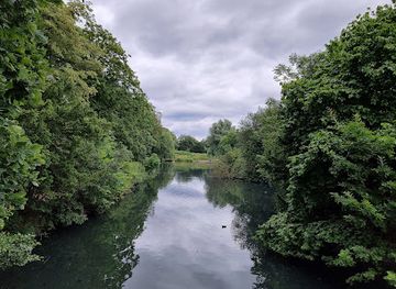
A historic 28-mile canalised river blending industrial heritage, urban vibrancy, and tranquil green spaces from Hertford to the Thames.

★★★★★4.5 (22)

The River Lee Navigation is a 28-mile canalised river flowing from Hertford Castle Weir through Hertfordshire and East London to join the River Thames at Bow Creek. With a rich history dating back to Roman times and significant industrial heritage, it offers a blend of urban vibrancy and peaceful natural scenery. The navigation features locks, towpaths for walking and cycling, and is a popular route for boating and outdoor recreation.

Plan your visit

A brief summary to River Lee Navigation

Opening times, essentials, and a few local tips gathered into one calmer, easier-to-scan planning section.

Plan your visit

📍
GB
🕒
Duration: 1 to 6 hours
💷
Free
🏛
Outdoor
📶
Mobile reception: 4 out of 5

Explore places near River Lee Navigation

    See all →

    Unlock the Best of River Lee Navigation

    Find tickets, tours with entry, and experiences available for this location.

    Buy tickets

    No tickets available

    Book tours with entry

    No tours with entry available

    Book tours without entry

    No tours without entry available

    Getting There

    Train and Walk

    Take a train to Hertford East station (approximately 30-45 minutes from London Liverpool Street), then enjoy a 20-30 minute walk to the navigation starting point at Hertford Castle Weir. This option offers scenic countryside access and is suitable for most travelers.

    Bus and Cycle

    Use local bus services connecting towns along the Lee Navigation, such as from Enfield or Walthamstow, combined with cycling along the towpath. Bus journeys vary between 20-50 minutes depending on the route. Cycling allows flexible exploration but requires a moderate fitness level.

    Boat Access

    Hire or travel by canal boat along the Lee Navigation from Hertford or other mooring points. Boating holidays typically last from a day to a week, offering a leisurely way to experience the waterway. Facilities for water and refuse disposal are available at key locations.

    For the on-the-go comforts that matter to you

    Restrooms
    Drink Options
    Drinking Water
    Food Options
    Seating Areas
    Trash Bins
    Information Boards

    Local tips

    Explore sections of the navigation on foot or bike using the Lea Valley Walk towpath for varied scenery and wildlife.
    Enjoy boating along the navigation with well-equipped mooring points and facilities managed by the Canal & River Trust.
    Visit historic sites like Hertford Lock, Bow Locks, and Three Mills House Mill to appreciate the navigation’s industrial past.
    Stop at canal-side pubs such as the Princess of Wales in Clapton for a relaxing break with waterside views.
    Be mindful of shared use on towpaths as they are popular with walkers, cyclists, and runners.

    River Lee Navigation location weather suitability

    Catch the right light and the right mood, whether you want a bright city moment or a more cinematic evening visit.

    Weather icon
    Any Weather
    Weather icon
    Rain / Wet Weather
    Weather icon
    Clear Skies
    Weather icon
    Mild Temperatures

    Discover more about River Lee Navigation

    An Ancient Watercourse Transformed for Navigation

    The River Lee Navigation traces its origins to the natural River Lea, which rises in the Chiltern Hills and flows southeast through Hertfordshire and East London before meeting the River Thames at Bow Creek. Historically, the river was a vital transport and trade route, with evidence of Bronze Age dugout canoes and Anglo-Saxon barges. In the medieval period, it supported numerous water mills and was a crucial artery for transporting grain to London. The first Act of Parliament to improve the river was passed in 1424, marking the beginning of centuries of canalisation and lock construction to facilitate navigation and commerce.

    Engineering and Industrial Heritage Along the Waterway

    The Lee Navigation as it exists today was largely shaped by 18th- and 19th-century improvements, including the creation of straight canal cuts, towpaths, and locks such as Hertford Lock and Bow Locks. These modifications allowed for more efficient movement of goods, especially during the Industrial Revolution when the Lower Lee Valley became a hub for chemical manufacturing, railways, and other industries. The navigation’s infrastructure reflects this heritage, with roving bridges and lock gates designed by pioneers like John Smeaton and William Jessop. The Limehouse Cut, connecting the navigation to the Thames, shortened travel times and enhanced London’s commercial waterways.

    Natural Beauty and Urban Green Spaces

    Today, the Lee Navigation offers a striking contrast between bustling urban environments and tranquil natural landscapes. Towpaths run alongside the waterway, popular with walkers, cyclists, and runners, passing through green spaces such as Walthamstow Marshes, Hackney Marshes, and the Lee Valley Park. The area supports diverse wildlife and includes nature reserves and reservoirs. Restoration projects linked to the 2012 London Olympics have enhanced access and improved habitats, making the navigation a valued recreational resource.

    Recreational Boating and Community Along the Waterway

    The navigation is a favored route for canal boaters, with mooring points and facilities such as water points and refuse stations at regular intervals. Boaters enjoy the mixture of countryside serenity near Hertford and the vibrant urban scenes closer to London. The navigation is lined with charming pubs and eateries, including canal-side terraces that provide social hubs for the boating community. The Canal & River Trust manages the waterway, promoting sustainable use and conservation.

    Walking and Cycling Routes with Historical Highlights

    The Lee Navigation towpath forms part of the Lea Valley Walk, a long-distance route extending from Waltham Abbey to Limehouse Basin. Along the way, visitors encounter historical sites such as Old Ford Locks, Three Mills House Mill, and remnants of industrial architecture. The route offers varied scenery, from peaceful rural stretches to lively urban quarters, appealing to a wide range of outdoor enthusiasts.

    Environmental and Cultural Significance Today

    The River Lee Navigation remains a vital green corridor through London, balancing heritage, recreation, and ecology. Efforts to clean and re-green the river have helped restore wildlife habitats and improve water quality. The navigation’s blend of history, nature, and urban life makes it a unique and cherished feature of the region’s landscape.

    Plan around the quieter times

    A quick look at seasonal patterns and peak visiting hours.

    Busiest months of the year

    Seasonality

    Busiest hours of the day

    Footfall
    Mobile App
    Get the app

    Your all‑in‑one travel companion app

    Explore expert travel guides, compare and book tours, experiences, hotels, and more—all from the palm of your hand. Download now for seamless trip planning wherever your wanderlust takes you.

    File:Syon House East Aspect.JPG - Wikipedia

    More about Middlesex

    Discover Middlesex: A blend of historic charm and modern excitement, offering scenic beauty, cultural events, and easy access to London.

    Tell me more about Middlesex

    Select Currency

    Choose the currency you want prices to display in.