Background

Burgh Castle Roman Fort

4.6 (804)

One of Britain’s best-preserved Roman forts, standing above the Norfolk Broads with sweeping views over Breydon Water and the surrounding marshes.

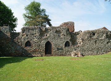
Standing proudly above the marshes of the Norfolk Broads, Burgh Castle is one of Britain’s best-preserved Roman forts. Built in the late 3rd century as part of the Saxon Shore defences, its massive flint and terracotta walls still rise to near their original height. From the ramparts, sweeping views stretch across Breydon Water to the Berney Arms Windmill and the surrounding estuary, a haven for birds and walkers. Managed by the Norfolk Archaeological Trust on behalf of English Heritage, the site is free to visit and offers a powerful sense of Roman military presence in East Anglia.

A brief summary to Burgh Castle

  • Monday 12 am-12 am
  • Tuesday 12 am-12 am
  • Wednesday 12 am-12 am
  • Thursday 12 am-12 am
  • Friday 12 am-12 am
  • Saturday 12 am-12 am
  • Sunday 12 am-12 am

Local tips

  • Wear sturdy footwear as paths can be muddy and uneven, especially after rain.
  • Visit in the late afternoon for golden light and fewer crowds, with the best views across Breydon Water.
  • Combine your visit with a walk to the nearby round-tower church of St Peter and St Paul and a stroll along the Angles Way footpath.
  • Bring binoculars to spot birds on Breydon Water and the Berney Arms Windmill in the distance.
  • There are no facilities at the site; use toilets and refreshments in the nearby village or marina before your visit.
widget icon

Do you manage this location?

Take control to get all the benefits, like improved information, better appearance, and stronger visibility across AI-powered discovery. Learn more

Activate your presence

Unlock the Best of Burgh Castle

Buy tickets

    No tickets available

Book tours with entry

    No tours available

Book tours without entry

    No tours available

Getting There

  • By car

    From Great Yarmouth or Lowestoft, follow local roads to Burgh Castle village. A small pay-and-display car park is located off Butt Lane, about a 10–15 minute walk from the fort across fields and footpaths. The approach is flat but can be muddy; parking is limited at peak times.

  • By foot

    From Burgh Castle Marina and holiday park, follow the Angles Way long-distance footpath for about half a mile to reach the fort. The route is well signed, mostly flat, and suitable for casual walkers, though paths can be wet underfoot after rain.

  • By boat

    On the Norfolk Broads, moor at the Broads Authority moorings on the River Yare just upstream from Breydon Water, then walk along the riverbank and footpaths to the fort. Be mindful of strong tides and limited landing spots near the site.

  • By public transport

    Take a bus to Burgh Castle village from Great Yarmouth or Lowestoft; the journey takes around 30–45 minutes. From the village, follow footpaths and lanes for about 15–20 minutes to reach the fort, crossing open fields and quiet country lanes.

For the on-the-go comforts that matter to you

  • Seating Areas
  • Trash Bins
  • Information Boards

Discover more about Burgh Castle

Walls That Have Watched Centuries

Burgh Castle Roman Fort, likely known to the Romans as Gariannonum, was built around AD 300 as a key Saxon Shore fort guarding the estuary of the River Waveney. Its massive stone walls, up to 4.5 metres high and 3.5 metres thick at the base, were designed to deter seaborne raiders and protect Roman interests along this vulnerable stretch of coast. Three of the four walls still stand impressively intact, enclosing a large rectangular space that once housed barracks, granaries, and a command centre. The west wall has long since collapsed into the marshes, but its absence only heightens the drama of the site, opening up panoramic views across Breydon Water.

A Landscape of Layers

The fort’s history extends far beyond the Roman period. After the Romans left, the site was reoccupied in the Anglo-Saxon era, possibly as the monastery of Cnobheresburh founded by St Fursey in the 7th century. Excavations have revealed a timber church and a large cemetery within the walls, evidence of a vibrant early Christian community. Later still, after the Norman Conquest, a motte-and-bailey castle was built inside the Roman enclosure, with a ditch cutting through the south wall. Today, the ramparts and earthworks bear the marks of all these phases, making Burgh Castle a rare palimpsest of military and religious life across more than a millennium.

Views Over the Broads

From the top of the fort’s walls, the landscape unfolds in a way that few Roman sites can match. To the north and west, Breydon Water spreads out like a vast inland sea, its reed-fringed banks alive with waders, wildfowl, and birds of prey. The iconic Berney Arms Windmill rises from the marshes, a 19th-century landmark visible from the ramparts. The estuary’s shifting tides and light create a constantly changing backdrop, from golden sunrises over the water to dramatic stormy skies. The fort’s elevated position, once chosen for strategic surveillance, now offers one of the most atmospheric viewpoints in the Norfolk Broads.

Exploring the Site Today

The main entrance today is through the eastern gate, where the scale of the fort becomes immediately apparent. Information boards around the site explain the layout, the Roman military presence, and the later Saxon and Norman phases. Visitors can walk the full circuit of the surviving walls, stand where Roman sentries once kept watch, and imagine the sounds of soldiers, traders, and monks who once lived here. The interior is open grassland, with subtle earthworks hinting at former buildings, and the remains of deep socket holes that once held lean-to structures or gantries. The atmosphere is one of quiet contemplation, with the wind in the reeds and the cry of distant birds replacing the bustle of ancient times.

Life Beyond the Walls

Just a short walk from the fort stands the village church of St Peter and St Paul, one of Norfolk’s distinctive round-tower churches. Parts of the tower and nave date from the late Saxon or early Norman period, and the building incorporates Roman tiles and masonry, a tangible link to the nearby fort. The surrounding landscape of the Broads, with its network of rivers, dykes, and marshes, reflects centuries of human interaction with the environment, from Roman shipping and Saxon salt pans to medieval drainage and modern conservation. Together, the fort, church, and estuary form a rich historical and natural tapestry that rewards a leisurely visit.

Busiest months of the year

Busiest hours of the day

Mobile App

Your all‑in‑one travel companion app

Explore expert travel guides, compare and book tours, experiences, hotels, and more—all from the palm of your hand. Download now for seamless trip planning wherever your wanderlust takes you.


More about The Broads

File:Canterbury Cathedral Aerial image (8634991805).jpg - Wikimedia Commons

Discover The Broads: A serene network of rivers and lakes in Norfolk and Suffolk, perfect for boating, wildlife watching, and tranquil countryside retreats.

Tell me more about The Broads

Select Currency