

Zarafshan Range Travel Guide - Free Web & App
Your ultimate guide to Zarafshan Range. Discover top landmarks, proposed trips, and local tips. Free on the web or via the Evendo companion app.


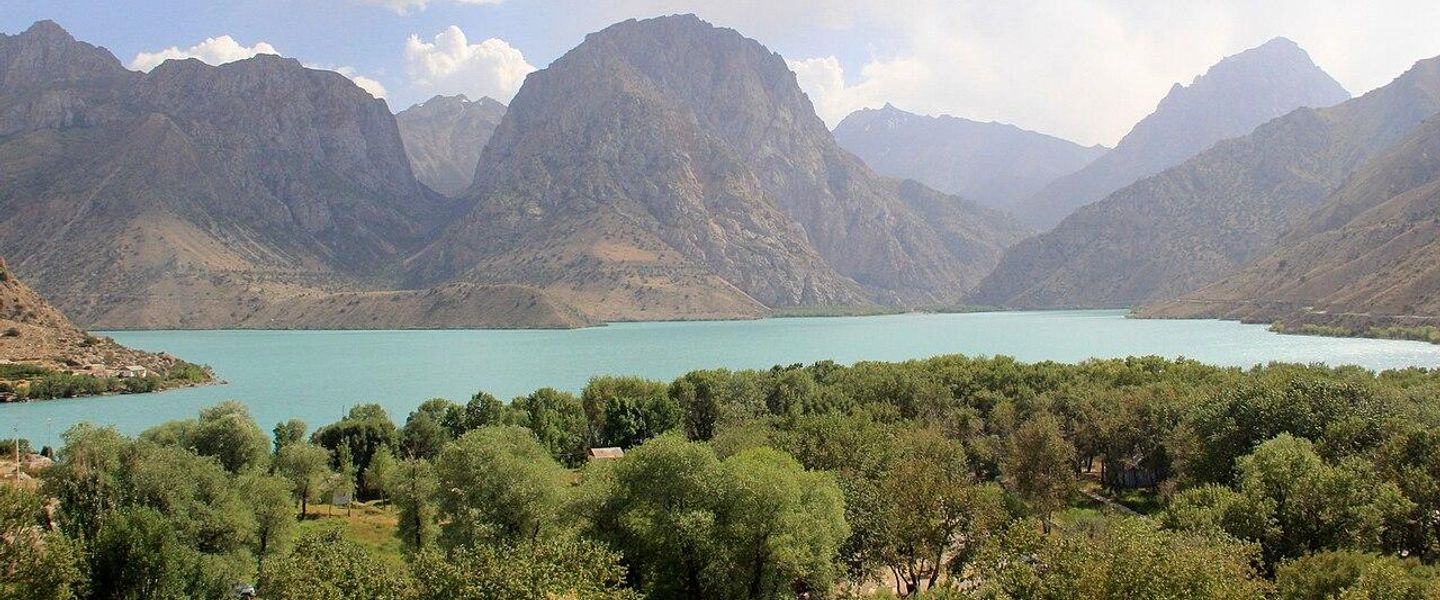


Zarafshan Range, Uzbekistan: explore mountain valleys, Omon-Kutan landscapes, Kitab geology, village culture and historic routes near Samarkand and Shahrisabz.
Mountain Landscapes and Geographic Character
The Zarafshan Range forms part of the western Pamir-Alay, rising through the borderlands of Uzbekistan and Tajikistan before giving way westwards to the valleys around Samarkand. In Uzbekistan, its character is generally that of a rugged mountain margin rather than a single, clearly defined resort area: dry foothills, narrow valleys, limestone and other exposed rock formations, cultivated slopes and scattered villages lead towards higher, more remote terrain. The most accessible approaches are associated with the Samarkand, Urgut and Kitab districts, while the range’s loftier eastern summits lie largely beyond Uzbekistan’s borders. The area is best understood as a landscape of gateways and protected sites rather than a destination with one central visitor hub.Read more about Zarafshan Range
Nature, Geology and Rural Life
Heritage and Exploring the Range
When is the best time to visit Zarafshan Range?
Best: April–May, September · 20–27°C| Month | High (°C) | Rainfall (mm) |
|---|---|---|
| January | 2 | 19 |
| February | 4 | 15 |
| March | 12 | 10 |
| April (best) | 20 | 6 |
| May (best) | 27 | 3 |
| June | 33 | 2 |
| July | 35 | 2 |
| August | 33 | 2 |
| September (best) | 26 | 5 |
| October | 18 | 10 |
| November | 8 | 14 |
| December | 4 | 17 |
Getting to and around Zarafshan Range
How to get there
Transportation
Explore Zarafshan Range on the map
Plan your trip on one map. See where the top attractions, landmarks, restaurants and hotels are, and book hotels and experiences in a few clicks.
Best hotels in Zarafshan Range
Get your free copy of our complete guide to Zarafshan Range, delivered straight to you.
Everything on this page, from attractions and restaurants to essentials and local phrases, in one PDF you can read offline, print or share.
Already have an account? Sign in
Your Zarafshan Range guide is ready.
We'll send it to · Not you? Sign out

Getting your guide ready…
We are putting together a fresh copy of the Zarafshan Range guide. This can take up to a minute.
This can take a few moments. If your browser asks, choose Allow so the download can start. You'll find the guide in your Downloads folder.
Nothing happened? Download it again
Sorry, the guide is taking longer than usual. Please try again in a minute, or get it by email instead.
Zarafshan Range essentials
Currency and Payment
Safety
Emergency Situations
Do's and Don'ts
Local Tips
From Eve
Local phrases worth knowing
You don't need to get them perfect. A few words go a long way, and locals appreciate the effort.
Basics
| English | Local | Say it |
|---|---|---|
| Hello | Салом | [Salom] |
| Goodbye | Хайр | [Khayr] |
| Yes | Ҳа | [Ha] |
| No | Йўқ | [Yo'q] |
| Please/You're welcome | Илтимос/Марҳамат | [Iltimos/Marhamat] |
| Thank you | Раҳмат | [Rahmat] |
| Excuse me/Sorry | Кечирасиз | [Kechirasiz] |
| How are you? | Нима кўришингиз? | [Nima ko'rishingiz?] |
| Fine. And you? | Жуда хубсангиз. Сизча? | [Juda hubsangiz. Sizcha?] |
| Do you speak English? | Инглиз тилини биласизми? | [Ingliz tilini bilasizmi?] |
| I don't understand | Мени тушунмади | [Meni tushunmadi] |
Eating & Drinking
| English | Local | Say it |
|---|---|---|
| I'd like to see the menu, please | Менюни кўрмоқчиман, илтимос | [Menyuni ko'rmoqchiman, iltimos] |
| I don't eat meat | Мен гўсфил учмайман | [Men go'sfil uchmayman] |
| Cheers! | Точиқ! | [Tochiq!] |
| I would like to pay, please | Тўлов қилишни истайман, илтимос | [Tolov qilishni istayman, iltimos] |
Emergencies
| English | Local | Say it |
|---|---|---|
| Help! | Ёрдам! | [Yordam!] |
| Go away! | Ёзил! | [Yozil!] |
| Call the Police! | Полицияни чақиринг! | [Poliyani chaqiring!] |
| Call a doctor! | Докторни чақиринг! | [Doktorni chaqiring!] |
| I'm lost | Мен йўлни йўқолдим | [Men yo'lni yo'qoldim] |
| I'm ill | Мен касалман | [Men kasalman] |
Shopping
| English | Local | Say it |
|---|---|---|
| I'd like to buy... | Сотиб олишни истайман... | [Sotib olishni istayman...] |
| I'm just looking | Фақат кўриб турмоқчиман | [Faqat ko'rib turmoqchiman] |
| How much is it? | Бу қанча пул? | [Bu qancha pul?] |
| That's too expensive | Бу жуда қиматли | [Bu juda qimatli] |
| Can you lower the price? | Нархни тўлағизми? | [Narxni to'lagizmi?] |
Time & Numbers
| English | Local | Say it |
|---|---|---|
| What time is it? | Соат қачон? | [Soat qachon?] |
| It's one o'clock | Бир соат | [Bir soat] |
| Half past (10) | Ёрдамчи (10) | [Yordamchi (10)] |
| Morning | Эрталаб | [Ertalab] |
| Afternoon | Кечаси | [Kechasi] |
| Evening | Кеч | [Kech] |
| Yesterday | Кеча | [Kecha] |
| Today | Бугун | [Bugun] |
| Tomorrow | Эртага | [Ertaga] |
| 1 | 1 | [1] |
| 2 | 2 | [2] |
| 3 | 3 | [3] |
| 4 | 4 | [4] |
| 5 | 5 | [5] |
| 6 | 6 | [6] |
| 7 | 7 | [7] |
| 8 | 8 | [8] |
| 9 | 9 | [9] |
| 10 | 10 | [10] |
Transport & Directions
| English | Local | Say it |
|---|---|---|
| Where's a/the...? | Қаерда...? | [Qaerda...?] |
| What's the address? | Манзил қаерда? | [Manzil qayerda?] |
| Can you show me (on the map)? | Менга кўрсатасизми (харитада)? | [Menga korsatasizmi (haritada)?] |
| When's the next (bus)? | Кейингиси (автобус) қачон? | [Keyingisi (avtobus) qachon?] |
| A ticket (to ....) | Билет (.... га) | [Bilet (.... ga)] |
History of Zarafshan Range
A Mountain Belt of Ancient Rocks
The Zarafshan Range belongs to the western Pamir-Alay, a complex mountain system shaped by long geological uplift and the erosion of sedimentary, metamorphic and igneous rocks. The exposed strata around Kitab are especially valuable to scientists because they preserve evidence of ancient marine environments and changing life forms through geological time. The Kitab Geological Reserve was established to protect this scientific record, making the area important not only as a mountain landscape but also as an open-air archive of Earth history. Geological processes here predate human settlement by immensely long periods and should be understood separately from the region’s later cultural history.
Routes Through the Zarafshan Valleys
Human movement around the range developed through the valleys and passes linking the Zarafshan and Kashka-Darya regions. Samarkand, at the western gateway to the wider mountain country, became one of Central Asia’s major urban centres, while smaller settlements including Urgut, Kitab and Shahrisabz grew through farming, craft production and regional exchange. The mountains were not an isolated barrier: they formed a network of routes between settled oases, upland pastures and neighbouring valleys. These connections help explain the mixture of agricultural, pastoral and trading traditions found around the Uzbek foothills.
Sacred Landscapes and Local Traditions
Mountain caves, springs and prominent ridges have long held religious and cultural importance in Central Asia. The shrine associated with Hazrat Daud, in the western foothills near Samarkand, is one of the best-known pilgrimage sites connected with the area. Visitors climb a long stairway to a cave identified in local tradition with the prophet David, known in Islamic tradition as Daud. The site’s significance is devotional rather than archaeological proof of the biblical figure’s presence, and its continuing appeal illustrates how natural formations can become part of living religious geography.
Protected Areas and Scientific Conservation
During the Soviet period, parts of the Uzbek mountain landscape were placed under formal protection for scientific study and nature conservation. Omon-Kutan became associated with the safeguarding of mountain habitats and forested ravines, while the Kitab Geological Reserve developed an international reputation for geological research and field education. Protected status has helped limit uncontrolled use of sensitive sites, although the balance between conservation, local livelihoods, pilgrimage and tourism remains important. Contemporary visitors encounter a landscape shaped by both natural processes and decades of scientific and environmental management.
Zarafshan Range in Photos
Browse through our photo collection highlighting the charm and character of the destination.
Neighbouring destination travel guides
The closest destinations to Zarafshan Range, if you have time for more than one.
-

-

-

-

-


Swipe for more destinations
Explore more

Explore more of Kyzylkum Desert
Explore Uzbekistan’s Kyzylkum Desert for dunes, Lake Aydar, ancient fortresses, petroglyphs, camel rides and exceptionally clear night skies.
Explore Kyzylkum Desert
Explore more of Uzbekistan
Discover Uzbekistan: A land of ancient cities, vibrant culture, and breathtaking landscapes, where history comes alive along the legendary Silk Road.
Explore Uzbekistan