

Yorkshire Dales National Park, United Kingdom Travel Guide
Yorkshire Dales National Park in the United Kingdom offers limestone landscapes, waterfalls, stone villages, heritage railways and memorable walking routes.
A Landscape of Valleys and Limestone
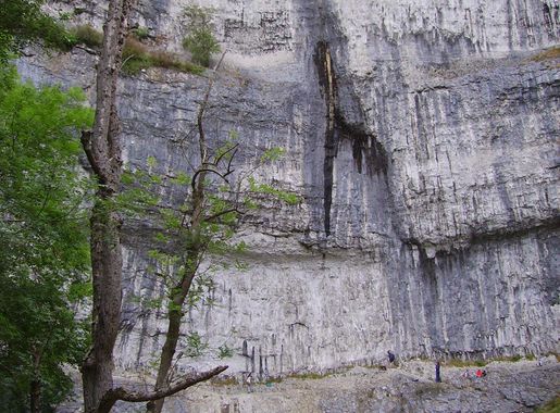
Yorkshire Dales National Park occupies a broad upland region in northern England, where rivers cut through limestone country, moorland rises towards the Pennines, and dry-stone walls divide fields around long-established farms. The park extends across parts of North Yorkshire and Cumbria, encompassing distinctive dales including Wharfedale, Wensleydale, Swaledale, Ribblesdale, Dentdale and Airedale. Each valley has its own character: limestone pavements and dramatic scars dominate around Malham, broad meadows follow the River Ure, and the remote northern valleys retain a strong pastoral identity.Villages, Heritage and Wildlife
Small settlements such as Grassington, Hawes, Reeth, Leyburn, Settle and Sedbergh provide gateways to footpaths, local museums, markets and valley roads. The landscape bears the marks of centuries of farming, quarrying, lead mining and transport. Stone barns, field barns, packhorse bridges, ruined mine workings and the Ribblehead Viaduct all contribute to the park's cultural character. Above ground, visitors may encounter curlews, lapwings, red grouse and peregrine falcons, while hay meadows and limestone grasslands support a rich variety of plants. Wildlife sightings are seasonal and never guaranteed, particularly in a working landscape where livestock and conservation management continue alongside tourism.Walking Through a Working Landscape
Walking is central to the Yorkshire Dales experience, from short paths to Malham Cove and Aysgarth Falls to longer routes across the Yorkshire Three Peaks and the Pennine Way. Cycling, scenic driving, caving and heritage railway journeys add further ways to explore, although distances between valleys and attractions can be considerable. Traditional inns, farm shops, local breweries and tearooms reflect the region's agricultural and culinary traditions, while changing weather, steep paths and rural road conditions demand practical preparation.
Know before you go
Hi, I'm Eve. Here are a few practical things to know before exploring Yorkshire Dales National Park.
- Use a detailed walking map and check weather conditions before setting out on upland routes, particularly around the Yorkshire Three Peaks.
- Choose a valley base such as Grassington, Hawes, Settle or Reeth when exploring several nearby attractions without excessive driving.
- Wear footwear suitable for mud, wet grass and uneven limestone, even on popular paths near Malham and Aysgarth.
- Keep dogs under close control around livestock and nesting birds, and follow signs about access, gates and seasonal restrictions.
- Carry food, water and a charged phone in remote dales, where shops, public transport and mobile coverage may be limited.
Explore Yorkshire Dales National Park: Things to Do, Places to Eat, Hotels & More
Handpicked recommendations for top attractions, local dining, accommodations, and more

Best attractions in Yorkshire Dales National Park
Top-rated picks
Best Attractions

Yorkshire Dales National Park
Explore the breathtaking limestone valleys, rugged peaks, and dark skies of Yorkshire’s iconic upland national park.

Ingleton Waterfalls Trail
A stunning 7km circular walk through ancient woodland and limestone gorges, where eight dramatic waterfalls cascade down the River Twiss and River Doe in the Yorkshire Dales.

Aysgarth Falls Yorkshire Dales National Park Visitor Centre
Explore the breathtaking three-tiered Aysgarth Falls and enjoy the welcoming National Park Visitor Centre with café, trails, and accessible facilities.
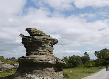
National Trust - Brimham Rocks
Explore Yorkshire’s ancient sculpted rock formations and vibrant heather moorland at Brimham Rocks, a natural wonder cared for by the National Trust.

Best landmarks in Yorkshire Dales National Park


Best restaurants in Yorkshire Dales National Park
Top-rated picks
Best Restaurants

Tan Hill Inn
Britain’s highest pub, The World Famous Tan Hill Inn offers historic charm, hearty local fare, and stunning Yorkshire Dales views in a remote, atmospheric setting.

The Lister Arms
Historic 17th-century coaching inn in Malham offering cozy rooms, hearty local cuisine, and a welcoming pub atmosphere in the heart of the Yorkshire Dales.

Craven Arms Pub & Cruck Barn
Experience authentic Yorkshire Dales hospitality with hearty food, local ales, and rustic charm at Craven Arms Pub & Cruck Barn.

The White Hart Inn, Hawes
Cozy Yorkshire Dales inn where historic pub warmth meets gastropub excellence, hearty meals, and hill-view rooms on Hawes' lively Main Street.

Best bars in Yorkshire Dales National Park
Top-rated picks
Best Bars
Aysgarth Falls Hotel & Restaurant
Charming hotel with stunning Yorkshire Dales views, fine dining, and cozy rooms near the iconic Aysgarth Falls.

The Buck Inn Malham
A rustic, welcoming pub and inn in Malham offering hearty fare and cozy rooms amid the stunning Yorkshire Dales landscape.

The Green Dragon Inn
Historic Yorkshire coaching inn with cozy fires, hearty pub fare, and scenic Dales setting near Hardraw Force waterfall.

The Gamekeeper's Inn
A charming countryside inn blending rustic hospitality, comfortable stays, and delicious local cuisine in the heart of the Yorkshire Dales.

Best nightclubs in Yorkshire Dales National Park
Top-rated picks
Best Nightclubs

The Queen's Head, Finghall
A quintessential English country pub and inn in Finghall offering hearty British fare, cozy rooms, and warm hospitality in scenic North Yorkshire.

Louis Bar
A vibrant nightclub and bar in Catterick Garrison offering live music, quality food, and a lively atmosphere for all-night entertainment.
sherdy sherd primary school
Experience Richmond’s vibrant nightlife at Sherdy Sherd Primary School, a uniquely named nightclub with extensive hours and lively atmosphere.

Best shops in Yorkshire Dales National Park
Top-rated picks
Best Shops

The Great Yorkshire Shop - Local gifts and souvenirs from Leeds & Yorkshire
Discover authentic Yorkshire gifts and souvenirs in a historic Victorian setting at The Great Yorkshire Shop in Leeds Corn Exchange.

The Yorkshire Hive
Boutique shopping, diverse dining, and family fun beside Yorkshire Wildlife Park’s wild adventures.

Carnforth Bookshop
Discover Carnforth Bookshop, a family-run independent haven of books, gifts, and local heritage in the heart of historic Lancashire.

C&K
A charming independent lifestyle store and café in Settle’s Market Place, blending boutique shopping with local flavors and welcoming ambiance.

Explore Yorkshire Dales National Park on the Map
A handpicked selection of must-see spots in Yorkshire Dales National Park, mapped for you.
Yorkshire Dales National Park Essentials
-
The national park is reached primarily by road from the A1(M), A65, A59 and A66, with approach routes leading to gateways including Skipton, Settle, Leyburn, Hawes, Richmond and Sedbergh. There is no single principal entrance or central transport hub. Rail services reach Skipton, Settle, Garsdale and Dent on or near the park's southern and western approaches, while the Settle–Carlisle Railway crosses the northern uplands. Leeds Bradford, Manchester and Teesside airports are the most relevant larger air gateways, but onward travel requires rail, bus, taxi or car. Check current routes before travelling, as rural services can be infrequent and seasonal.
-
A car is often the most flexible way to connect the widely dispersed dales, although narrow lanes, steep gradients, blind bends, cyclists, livestock and limited parking require patience. Local bus services link some settlements, including routes serving places such as Grassington, Hawes, Leyburn, Settle and Reeth, but they do not provide comprehensive access to every attraction. Walking is the principal way to explore individual valleys, with public footpaths, bridleways and long-distance routes crossing the park. Cycling is rewarding but demanding on hilly roads. The Settle–Carlisle Railway offers a practical and scenic way to reach parts of the western and northern park, subject to current service arrangements.
-
The currency is the pound sterling, written as GBP or £. Cards and contactless payments are widely accepted in larger villages, accommodation businesses, pubs, cafés and visitor attractions, although smaller rural establishments, honesty boxes and some seasonal facilities may prefer or require cash. Cash machines are more likely to be found in gateway towns such as Settle, Hawes, Leyburn and Richmond than in remote hamlets, and some may charge fees or have limited availability. Carrying a modest amount of sterling is sensible when walking or travelling between settlements, while visitors should not assume that mobile payment signals will be reliable throughout the uplands.
-
Weather can change quickly on exposed hills, even when conditions are settled in the valleys. Paths may be slippery, muddy or uneven, and limestone terrain includes steep edges, deep fissures, caves and potholes; keep to appropriate routes and observe warning signs. Rivers and waterfalls can become hazardous after heavy rain, while roads are narrow and shared with walkers, cyclists, motorcyclists and farm vehicles. Carry navigation equipment, suitable clothing, food and water on longer walks, and do not rely solely on mobile coverage. Keep dogs under control around livestock and cliff edges, and avoid entering mine workings or caves unless accompanied by suitable expertise and permission.
-
Call 999 or 112 for police, fire, ambulance or other emergency assistance in the United Kingdom. Give the operator the nature of the incident and as precise a location as possible, using a named road, dale, footpath, grid reference, landmark or what3words location if available. In remote terrain, explain access difficulties and remain with an injured person where it is safe to do so. Mobile coverage varies considerably across the park, so tell someone your route before a longer walk and consider carrying a paper map. For urgent medical needs, emergency services can direct visitors to the appropriate facility; do not assume that a rural village has a hospital or emergency department.
-
Follow the Countryside Code by leaving gates as you find them, keeping to marked paths where requested, taking litter home and giving way considerately on narrow tracks. Keep dogs close or on a lead around livestock and at times of ground-nesting bird activity, and never feed animals. Do not climb on walls, enter abandoned mine workings, disturb wildlife or block farm gateways and passing places. Respect private homes, working farms and places of worship, particularly in small villages. Wild camping, fires, swimming, fishing and access to caves or quarries are not automatically permitted everywhere, so check local signs, landowner guidance and relevant regulations.
-
The park is best understood as a collection of contrasting valleys rather than one compact attraction. Malham and Wharfedale suit visitors interested in limestone scenery, while Wensleydale, Swaledale and Arkengarthdale offer quieter roads, farming heritage and mining remains. Settle is useful for southern access, Hawes for Wensleydale and the western dales, and Reeth for Swaledale and Arkengarthdale. Begin popular walks early when possible and allow more time than map distances suggest because gradients, gates, stiles and weather can slow progress. Spring hay meadows, summer uplands, autumn colour and winter light each give the valleys a different character, but conditions vary year by year.
When is the best time to visit Yorkshire Dales National Park?
Useful Local Phrases for Yorkshire Dales National Park
You don't need to speak the language perfectly. Even learning a few simple words can make conversations warmer—and locals usually appreciate the effort.
— Eve

Here are the phrases I use most often in Yorkshire Dales National Park. Try a few—you'll be surprised how far they go! 😊
❤️
-
- HelloEy up
[ay up] - GoodbyeTa-ra
[ta-rah] - YesAye
[ai] - NoNaa
[nah] - Please/You're welcomePlease
[pleez] - Thank youCheers
[cheers] - Excuse me/SorrySorry
[sorry] - How are you?How's tha?
[how's tha] - Fine. And you?Reet. And tha?
[reet. And tha] - Do you speak English?Do ya speak English?
[do ya speak English] - I don't understandI dunna understand
[I dunna understand]
- HelloEy up
-
- I'd like to see the menu, pleaseCan I see the menu, please?
[can I see th' menu, pleez?] - I don't eat meatI don't eat meat
[I don't eat meat] - Cheers!Cheers!
[cheers] - I would like to pay, pleaseCan I pay, please?
[can I pay, pleez?]
- I'd like to see the menu, pleaseCan I see the menu, please?
-
- Help!Help!
[help] - Go away!Clear off!
[clear off] - Call the Police!Ring the rozzers!
[ring th' rozzers] - Call a doctor!Get a doc!
[get a doc] - I'm lostI'm a bit lost
[I'm a bit lost] - I'm illI'm poorly
[I'm poorly]
- Help!Help!
-
- I'd like to buy...I’d like to buy...
[I’d like to buy...] - I'm just lookingI'm just having a gander
[I'm just havin' a gander] - How much is it?How much's this?
[how much's this?] - That's too expensiveThat's a bit steep
[that's a bit steep] - Can you lower the price?Can ya knock some off?
[can ya knock some off?]
- I'd like to buy...I’d like to buy...
-
- What time is it?What time's it?
[what time's it?] - It's one o'clockIt's one o'clock
[it's one o'clock] - Half past (10)Half past ten
[half past ten] - MorningMorning
[morning] - AfternoonAfternoon
[afternoon] - EveningEvening
[evening] - YesterdayYest'day
[yest'day] - TodayToday
[today] - TomorrowTomorra
[tomorra] - 1One
[one] - 2Two
[two] - 3Three
[three] - 4Four
[four] - 5Five
[five] - 6Six
[six] - 7Seven
[seven] - 8Eight
[eight] - 9Nine
[nine] - 10Ten
[ten]
- What time is it?What time's it?
-
- Where's a/the...?Where's a/the...?
[where's a/the...?] - What's the address?What's th' address?
[what's th' address?] - Can you show me (on the map)?Can ya show me (on th' map)?
[can ya show me (on th' map)?] - When's the next (bus)?When's th' next (bus)?
[when's th' next (bus)?] - A ticket (to ....)A ticket (to ....)
[a ticket (to ....)]
- Where's a/the...?Where's a/the...?
History of Yorkshire Dales National Park
-
The foundations of the Yorkshire Dales were laid mainly in Carboniferous rocks formed in warm tropical seas more than 300 million years ago. The resulting limestone, sandstone and shale were later uplifted and shaped by rivers, frost and successive glaciations. Glacial action helped create broad U-shaped valleys, while water dissolving the limestone produced caves, potholes, gorges and pavements. Features such as Malham Cove, Gordale Scar and the limestone scenery of Ingleborough are therefore products of geological processes rather than human construction. The underlying geology continues to influence farming, settlement, building materials and the location of springs and waterfalls across the park.
-
Evidence of prehistoric activity survives in the wider Dales through stone monuments, enclosures and routes that crossed the uplands, although settlement was often concentrated in more sheltered valleys. Later communities developed an agricultural system based on cattle, sheep, meadow hay and common grazing. Medieval monasteries held extensive estates in and around the region, with Bolton Abbey among the most visible surviving religious and architectural legacies. Villages grew around churches, markets, mills and crossing points, while packhorse routes connected isolated communities with markets beyond the valleys. The distinctive pattern of stone barns, small fields and drystone walls reflects this long history of farming and communal land management.
-
From the medieval period and particularly during the eighteenth and nineteenth centuries, lead mining became an important industry in parts of Swaledale, Arkengarthdale, Wensleydale and the northern dales. Miners worked veins in the hillsides, leaving shafts, spoil heaps, hushes, dressing floors and smelt-mill remains that are now part of the cultural landscape. Local industries also included quarrying, wool production, corn milling and lime burning. Mining brought employment and trade but altered fragile upland environments, and many workings were later abandoned as ore became less profitable. Their remains help explain why the Dales is not simply a pastoral landscape but a record of changing rural economies.
-
Nineteenth-century transport improvements connected the valleys more closely with industrial towns and regional markets. The Settle–Carlisle Railway, completed in 1876, crossed the high ground beside Ribblehead and required major viaducts, tunnels and embankments. Railways also supported the movement of livestock, stone, minerals and visitors, though several branch lines later closed. Tourism expanded as walking, climbing, caving and appreciation of rural scenery became more popular, aided by improved roads and guidebooks. The development of villages such as Grassington, Hawes and Settle as visitor centres reflects this transition from predominantly local agricultural economies to communities serving both residents and visitors.
-
Yorkshire Dales National Park was designated in 1954, bringing a formal conservation framework to a landscape still shaped by farming, settlements and working quarries. Its purpose combines protection of natural beauty and cultural heritage with support for local communities and sustainable recreation. The park was substantially extended in 2016, bringing additional areas of Cumbria and Lancashire within its boundaries. Modern management addresses pressures including footpath erosion, habitat loss, changing agricultural practices and the conservation of hay meadows, limestone grasslands, woodlands and peatlands. The present Dales is consequently a living landscape in which farming, biodiversity, heritage and public access remain closely connected.
Cities in Yorkshire Dales National Park
Browse our curated selection of top destinations, scenic points, and must-visit spots in the area.


Neighbouring destination travel guides
Browse our curated selection of top destinations, scenic points, and must-visit spots in the area.


Your all‑in‑one travel companion app
Explore expert travel guides, compare and book tours, experiences, hotels, and more—all from the palm of your hand. Download now for seamless trip planning wherever your wanderlust takes you.


Explore More of Westmorland

Looking beyond Yorkshire Dales National Park? Discover Westmorland for broader travel guides, local hot-spots, and regional highlights.
Explore WestmorlandExplore More of United Kingdom

Looking beyond Yorkshire Dales National Park? Discover United Kingdom for broader travel guides, local hot-spots, and regional highlights.
Explore United KingdomYorkshire Dales National Park in Photos
Browse through our photo collection highlighting the charm and character of the destination.




Yorkshire Dales National Park: Limestone, Valleys and Stone Villages
<h3>A Landscape of Valleys and Limestone</h3> Yorkshire Dales National Park occupies a broad upland region in northern England, where rivers cut through limestone country, moorland rises towards the Pennines, and dry-stone walls divide fields around long-established farms. The park extends across parts of North Yorkshire and Cumbria, encompassing distinctive dales including Wharfedale, Wensleydale, Swaledale, Ribblesdale, Dentdale and Airedale. Each valley has its own character: limestone pavements and dramatic scars dominate around Malham, broad meadows follow the River Ure, and the remote northern valleys retain a strong pastoral identity. <h3>Villages, Heritage and Wildlife</h3> Small settlements such as Grassington, Hawes, Reeth, Leyburn, Settle and Sedbergh provide gateways to footpaths, local museums, markets and valley roads. The landscape bears the marks of centuries of farming, quarrying, lead mining and transport. Stone barns, field barns, packhorse bridges, ruined mine workings and the Ribblehead Viaduct all contribute to the park's cultural character. Above ground, visitors may encounter curlews, lapwings, red grouse and peregrine falcons, while hay meadows and limestone grasslands support a rich variety of plants. Wildlife sightings are seasonal and never guaranteed, particularly in a working landscape where livestock and conservation management continue alongside tourism. <h3>Walking Through a Working Landscape</h3> Walking is central to the Yorkshire Dales experience, from short paths to Malham Cove and Aysgarth Falls to longer routes across the Yorkshire Three Peaks and the Pennine Way. Cycling, scenic driving, caving and heritage railway journeys add further ways to explore, although distances between valleys and attractions can be considerable. Traditional inns, farm shops, local breweries and tearooms reflect the region's agricultural and culinary traditions, while changing weather, steep paths and rural road conditions demand practical preparation.