

Tombigbee River Travel Guide - Free Web & App
Your ultimate guide to Tombigbee River. Discover top landmarks, proposed trips, and local tips. Free on the web or via the Evendo companion app.


Tombigbee River, Alabama, offers boating, fishing, wildlife, Civil War history and river towns along the Tennessee–Tombigbee Waterway.
A River Across West Alabama
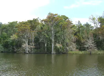
The Tombigbee River is one of Alabama’s defining waterways, flowing south through the western part of the state before joining the Alabama River system and continuing towards Mobile Bay. Its Alabama landscape ranges from wooded banks, quiet backwaters and broad floodplains to engineered channels shaped by the Tennessee–Tombigbee Waterway. Rather than a single concentrated attraction, the river is a long, changing destination best explored through its settlements, public access points, reservoirs, historic sites and surrounding countryside.Read more about Tombigbee River
Water, Wildlife and Working Landscapes
History Along the Banks
When is the best time to visit Tombigbee River?
Best: April–May, October · 25–29°C| Month | High (°C) | Rainfall (mm) |
|---|---|---|
| January | 14 | 110 |
| February | 17 | 100 |
| March | 21 | 120 |
| April (best) | 25 | 100 |
| May (best) | 29 | 100 |
| June | 33 | 110 |
| July | 34 | 140 |
| August | 34 | 120 |
| September | 31 | 100 |
| October (best) | 25 | 80 |
| November | 19 | 100 |
| December | 14 | 110 |
Getting to and around Tombigbee River
How to get there
Transportation
Best attractions in Tombigbee River
The Tombigbee River’s attractions are distributed along a broad Alabama corridor rather than concentrated in one visitor centre. Demopolis provides the strongest combination of river access, local museums, historic architecture and connections with the Black Warrior–Tombigbee system, while the surrounding countryside reveals wooded banks, sloughs, floodplain fields and working navigation channels. The Tennessee–Tombigbee Waterway introduces locks, reservoirs and engineered cuts that are particularly interesting to visitors following the river’s modern commercial role. Near Epes, the Fort Tombecbé area connects the landscape with eighteenth-century French activity and the history of Indigenous-European exchange. Smaller communities including Gainesville and Coffeeville offer quieter gateways to fishing, boating and rural river scenery, although facilities are dispersed and public access varies. Wildlife observation is best approached patiently from established access areas, where birds and other riverine species may be encountered without disturbing sensitive habitat or interfering with navigation.
-
State park
Gulf State Park
Discover Alabama's Gulf Coast paradise: beaches, trails, fishing, and nature await at Gulf State Park in Gulf Shores.
-
Museum
Fort Morgan State Historic Site
Explore a historic military fort on Alabama's Gulf Coast, offering a glimpse into the past and stunning views of Mobile Bay.
-
Tourist attraction
Bellingrath Gardens & Home
Experience the beauty of the South at Bellingrath Gardens & Home, a historic estate with stunning gardens and a glimpse into the past.
-
Tourist attraction
Five Rivers Delta Center
Explore Alabama's Mobile-Tensaw Delta: nature trails, boat tours, and conservation education at the Five Rivers Delta Center in Spanish Fort.


Explore Tombigbee River on the map
Plan your trip on one map. See where the top attractions, landmarks, restaurants and hotels are, and book hotels and experiences in a few clicks.
Best hotels in Tombigbee River
Best restaurants in Tombigbee River
Dining along the Tombigbee is concentrated in Demopolis and other river communities rather than at isolated banks or boat ramps. Visitors can expect the broad culinary character of west and central Alabama, including Southern home cooking, barbecue, catfish and other freshwater fish where locally served, biscuits, vegetables, pecan-based sweets and familiar American café fare. Country stores, independent restaurants and casual eateries in gateway settlements are more relevant to the river experience than a formal dining district, while larger towns provide the widest choice of groceries and takeaway food for boating trips. Local produce and agricultural traditions reflect the fertile river lowlands, although menus vary by season and establishment. Anyone travelling to a remote access point should obtain provisions beforehand and avoid assuming that food service is available beside the water.
-
River
Tombigbee River
Explore Alabama's Tombigbee River - A Nature Lover's Paradise with Scenic Views and Outdoor Adventures Awaiting You.

Best bars in Tombigbee River
The Tombigbee River does not have a continuous nightlife scene, and evening entertainment is generally low-key. Demopolis offers the broadest choice of established restaurants, bars and community events associated with a regional town, while smaller river settlements tend to centre their social life on local restaurants, informal gatherings and traditional pubs or bars where available. Evenings in the rural corridor are more likely to involve sitting outdoors, watching the water, attending a civic or seasonal event, or returning to accommodation after time on the river than visiting a nightclub. Event programmes and opening arrangements vary, so visitors should check locally rather than expect regular performances or late-night venues at every river community.
-
Family-friendly
Stagecoach Cafe
Discover delicious Southern cuisine at Stagecoach Cafe, a family-friendly buffet restaurant in Stockton, Alabama, perfect for all ages.
-
Fast Food
Ed's Drive-In
Discover Ed's Drive-In, where classic American fast food meets a nostalgic atmosphere in the heart of Jackson, Alabama.
-
Grill
Top of the Bay
Experience the perfect combination of delicious grilled cuisine and exciting live music at Top of the Bay in Daphne, Alabama.
-
Grill
Lil' Touch Of Cajun Grill
Experience authentic Cajun cuisine at Lil' Touch Of Cajun Grill in Jackson, AL, where bold flavors and a warm atmosphere await every food lover.


Best nightclubs in Tombigbee River
The Tombigbee River does not have a continuous nightlife scene, and evening entertainment is generally low-key. Demopolis offers the broadest choice of established restaurants, bars and community events associated with a regional town, while smaller river settlements tend to centre their social life on local restaurants, informal gatherings and traditional pubs or bars where available. Evenings in the rural corridor are more likely to involve sitting outdoors, watching the water, attending a civic or seasonal event, or returning to accommodation after time on the river than visiting a nightclub. Event programmes and opening arrangements vary, so visitors should check locally rather than expect regular performances or late-night venues at every river community.
-
River
Tombigbee River
Discover the natural beauty and rich history of the Tombigbee River in Alabama, where adventure and tranquility await every traveler.

Best shops in Tombigbee River
Shopping opportunities are modest and spread through the river’s gateway communities. Demopolis has the most useful concentration of everyday shops, groceries, outdoor supplies and locally oriented businesses for visitors preparing to explore the waterway, while smaller settlements such as Gainesville and Coffeeville provide more limited provisions. Regional products may include Alabama-made foods, pecans, preserves, barbecue supplies, pottery, artwork and other crafts sold through independent businesses or seasonal events, although availability changes and should not be assumed at every stop. Farm stands and country stores can reflect the agricultural character of the Tombigbee lowlands, but they are not uniformly distributed along the river. Travellers heading to remote ramps should purchase fuel, food, drinks, fishing supplies and essentials in a larger town before continuing.
-
Discount store
Dirt Cheap
Explore unbeatable bargains at Dirt Cheap in Jackson, Alabama - your one-stop discount store for incredible savings on everyday items.
-
Women's clothing store
A Little Bird Boutique
Discover fashion and unique gifts at A Little Bird Boutique in Grove Hill, Alabama, where style meets Southern charm.
-
Department store
Moms + Pops
Discover unique finds and local charm at Moms + Pops, your go-to department store in Jackson, Alabama for an unforgettable shopping experience.
-
Gas station
Tom Bigee River Store
Experience Southern hospitality at Tom Bigee River Store, where great food meets friendly service in Toxey, Alabama.


Get your free copy of our complete guide to Tombigbee River, delivered straight to you.
Everything on this page, from attractions and restaurants to essentials and local phrases, in one PDF you can read offline, print or share.
Already have an account? Sign in
Your Tombigbee River guide is ready.
We'll send it to · Not you? Sign out

Getting your guide ready…
We are putting together a fresh copy of the Tombigbee River guide. This can take up to a minute.
This can take a few moments. If your browser asks, choose Allow so the download can start. You'll find the guide in your Downloads folder.
Nothing happened? Download it again
Sorry, the guide is taking longer than usual. Please try again in a minute, or get it by email instead.
Tombigbee River essentials
Currency and Payment
Safety
Emergency Situations
Do's and Don'ts
Local Tips
From Eve
Local phrases worth knowing
You don't need to get them perfect. A few words go a long way, and locals appreciate the effort.
Basics
| English | Local | Say it |
|---|---|---|
| Hello | Howdy | [Hou-dee] |
| Goodbye | See ya | [See yah] |
| Yes | Yessir | [Yes-sir] |
| No | Nah | [Nah] |
| Please/You're welcome | Please/You're welcome | [Pleez/Yer welcome] |
| Thank you | Thank ya | [Thank yah] |
| Excuse me/Sorry | Pardon me | [Par-dun me] |
| How are you? | How y'all doin'? | [Hou y'all doin'] |
| Fine. And you? | Fine. And you? | [Fine. And you?] |
| Do you speak English? | Y'all speak English? | [Y'all speak Ing-lish?] |
| I don't understand | I don't get it | [I don't get it] |
Eating & Drinking
| English | Local | Say it |
|---|---|---|
| I'd like to see the menu, please | Let me see what y'all got to eat, please | [Let me see what y'all got to eat, please] |
| I don't eat meat | I don't eat meat | [I don't eat meat] |
| Cheers! | Cheers! | [Cheers!] |
| I would like to pay, please | I need to settle up, please | [I need to settle up, please] |
Emergencies
| English | Local | Say it |
|---|---|---|
| Help! | Help! | [Help!] |
| Go away! | Git! | [Git!] |
| Call the Police! | Call the Sheriff! | [Call the Sheriff!] |
| Call a doctor! | Call the doc! | [Call the doc!] |
| I'm lost | I'm turned around | [I'm turned around] |
| I'm ill | I'm feelin' poorly | [I'm feelin' poorly] |
Shopping
| English | Local | Say it |
|---|---|---|
| I'd like to buy... | I wanna get... | [I wanna get...] |
| I'm just looking | I'm just lookin' | [I'm just lookin'] |
| How much is it? | How much d'ya want for it? | [How much d'ya want for it?] |
| That's too expensive | That's too pricey | [That's too pricey] |
| Can you lower the price? | Can ya do better on the price? | [Can ya do better on the price?] |
Time & Numbers
| English | Local | Say it |
|---|---|---|
| What time is it? | What time it be? | [What time it be?] |
| It's one o'clock | It's one o'clock | [It's one o'clock] |
| Half past (10) | Half past (10) | [Half past (10)] |
| Morning | Mornin' | [Mornin'] |
| Afternoon | Afternoon | [Afternoon] |
| Evening | Evenin' | [Evenin'] |
| Yesterday | Yest'day | [Yest'day] |
| Today | Today | [Today] |
| Tomorrow | Tomorrah | [Tomorrah] |
| 1 | One | [One] |
| 2 | Two | [Two] |
| 3 | Three | [Three] |
| 4 | Four | [Four] |
| 5 | Five | [Five] |
| 6 | Six | [Six] |
| 7 | Seven | [Seven] |
| 8 | Eight | [Eight] |
| 9 | Nine | [Nine] |
| 10 | Ten | [Ten] |
Transport & Directions
| English | Local | Say it |
|---|---|---|
| Where's a/the...? | Where's a/the...? | [Where's a/the...?] |
| What's the address? | What's the address? | [What's the address?] |
| Can you show me (on the map)? | Can you show me (on the map)? | [Can you show me (on the map)?] |
| When's the next (bus)? | When's the next (bus)? | [When's the next (bus)?] |
| A ticket (to ....) | A ticket (to ....) | [A ticket (to ....)] |
History of Tombigbee River
A River Shaped by Deep Time
The Tombigbee occupies a long alluvial corridor in the southeastern United States, carrying sediment through a landscape of floodplains, terraces, tributaries and bottomland forest. Its course has changed over geological and historical time as floods, erosion and deposition reshaped the river margins. These processes produced fertile lowlands that later attracted settlement and agriculture, while the river itself became a natural route through the interior of what is now Alabama.
Indigenous River Networks
Long before European settlement, Indigenous peoples used the Tombigbee and its tributaries as routes for travel, exchange and communication. The river lay within a region associated with Choctaw and Chickasaw peoples, whose communities, agricultural systems and political relationships shaped the wider landscape. The name Tombigbee is generally linked to Indigenous language, although historical spellings and interpretations vary. River access connected inland settlements with larger networks extending across present-day Mississippi and Alabama.
French Fort Tombecbé
In the eighteenth century, the Tombigbee became a focus of French colonial strategy and trade. Fort Tombecbé was established in 1736 on the river near the present community of Epes, providing a military and commercial foothold in a region where European powers competed for influence and Indigenous alliances. The fort did not develop into a large settlement, but its location illustrates the river’s importance as a corridor between the Gulf Coast, interior communities and the wider Mississippi Valley.
Steamboats, Plantations and River Commerce
During the nineteenth century, steamboats and smaller craft used the Tombigbee to move agricultural produce, people and supplies. Towns and landings grew in importance along accessible stretches, while cotton agriculture and timber extraction altered the surrounding countryside. Navigation was never entirely straightforward: shifting channels, seasonal water levels and snags affected movement, encouraging repeated efforts to improve river access. The river also became part of the economic geography of antebellum Alabama and the transport systems that supported the Confederacy during the American Civil War.
Engineering the Tennessee–Tombigbee Waterway
The modern river landscape was substantially transformed by the Tennessee–Tombigbee Waterway, a large navigation project completed in the 1980s. The system links the Tennessee River with the Tombigbee and improves access between the inland waterways and the Gulf-connected network. Its locks, dams, reservoirs and altered channels support commercial navigation while also creating opportunities for boating and fishing. The project brought major economic and physical change, but it also modified floodplain relationships and habitats along parts of the historic river corridor.
Conservation and Contemporary River Life
Today the Tombigbee combines navigation, recreation, agriculture, industry and wildlife habitat. River management is shared among federal, state and local authorities, with navigation infrastructure operating alongside wetlands, forests and public access areas. Demopolis and smaller river communities retain connections to the water through museums, historic sites, marinas, fishing and civic events. Contemporary visitors encounter a landscape whose character depends on both natural processes and decades of engineering, making conservation, flood management and responsible recreation important parts of its continuing history.
Tombigbee River in Photos
Browse through our photo collection highlighting the charm and character of the destination.
Cities in Tombigbee River
The towns and cities of Tombigbee River, and the easiest places to base yourself.
-
-

-
-

-

-


Swipe for more cities
Neighbouring destination travel guides
The closest destinations to Tombigbee River, if you have time for more than one.
-

-

-

-

-


Swipe for more destinations
Explore more

Explore more of Gulf Coast
Explore Alabama’s Gulf Coast for white-sand beaches, seafood, barrier-island wildlife, Mobile’s history and outdoor adventures around Mobile Bay.
Explore Gulf Coast
Explore more of Alabama
Discover Alabama: A Southern state rich in history, culture, and natural beauty, offering unforgettable experiences from vibrant cities to serene beaches and majestic mountains.
Explore Alabama