

Free Northern Rivers Travel Guide & Mobile App
Explore Northern Rivers with free travel guides. Discover regional history, expert tips, proposed trips, and audio guides on web or mobile app.


Explore Northern Rivers for surf beaches, rainforest walks, river towns, creative culture and fresh produce across north-eastern New South Wales.
Read more about Northern Rivers
When is the best time to visit Northern Rivers?
Best: April–May, October · 22–26°C| Month | High (°C) | Rainfall (mm) |
|---|---|---|
| January | 28 | 151 |
| February | 29 | 141 |
| March | 28 | 130 |
| April (best) | 26 | 120 |
| May (best) | 22 | 110 |
| June | 19 | 101 |
| July | 18 | 91 |
| August | 19 | 101 |
| September | 21 | 110 |
| October (best) | 24 | 120 |
| November | 27 | 130 |
| December | 28 | 140 |
Getting to and around Northern Rivers
How to get there
Transportation
Top city travel guides in Northern Rivers
The cities of Northern Rivers, and the easiest places to base yourself.
-

-

-


Swipe for more cities
Best attractions in Northern Rivers
Northern Rivers offers a varied attraction landscape rather than one concentrated sightseeing circuit. On the coast, Byron Bay combines beaches, surfing, the Cape Byron headland and maritime history, while Ballina’s riverfront, coastal reserves and aviation heritage give the Richmond River town a different character. The Tweed Coast links beach communities with estuaries, wetlands and the productive Tweed Valley. Southwards, Evans Head, Yamba and Iluka provide access to long beaches, river mouths and protected coastal environments. Inland, Murwillumbah and Lismore are gateways to galleries, local food, historic streets and rural landscapes. National parks add the region’s strongest natural experiences: Nightcap protects rainforest and waterfall country, Border Ranges preserves elevated forests and escarpment views, and Bundjalung National Park encompasses coastal heath, waterways and beaches. Around the Clarence Valley, river journeys, cane country and towns such as Grafton broaden the picture. Walking, kayaking, surfing, cycling and wildlife observation are central activities, but many outdoor sites are weather-dependent and some tracks or facilities may close after flooding, fire or other environmental events.
-
Theme park
Sea World
Experience the thrill of rides and the beauty of marine life at Sea World, a premier theme park in Main Beach, Queensland, perfect for family fun and adventure.
-
Theme park
Dreamworld
Discover Dreamworld, Australia's largest theme park, offering thrilling rides, wildlife encounters, and family-friendly fun in Coomera, Queensland.
-
Wildlife park
Currumbin Wildlife Sanctuary
Explore the wonders of Australian wildlife at Currumbin Wildlife Sanctuary, a top family-friendly attraction in Queensland with interactive experiences and conservation efforts.
-
Park
Cape Byron State Conservation Area
Discover the stunning landscapes and rich biodiversity of Cape Byron State Conservation Area, the easternmost point of Australia, perfect for hiking and exploration.


Best landmarks in Northern Rivers
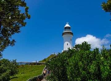
Cape Byron Lighthouse is Northern Rivers’ most recognisable coastal landmark, standing on the Byron Bay headland above the meeting of the Pacific Ocean and the bay; the surrounding headland also marks Australia’s eastern mainland point. Wollumbin, formerly Mount Warning, dominates views across the Tweed Valley and carries profound cultural significance for local Aboriginal communities, although access to Wollumbin National Park and the summit has been subject to closure. The Big Prawn at Ballina is a more recent, deliberately popular landmark reflecting the town’s river-port and seafood identity. In the south, the Clarence River and Grafton’s historic bridge and civic townscape express the importance of river transport and regional administration. Iluka’s coastal forest and nearby estuary landscapes, the Richmond River at Ballina and the cane-fringed Tweed Valley are geographical landmarks rather than single monuments. Historic churches, courthouses, railway remnants and timber-era buildings in towns such as Lismore, Murwillumbah and Grafton add architectural evidence of the region’s agricultural and transport past.
-
Park
Cape Byron State Conservation Area
Explore the stunning landscapes and rich biodiversity of Cape Byron State Conservation Area, the easternmost point of mainland Australia.
-
Tourist attraction
Crystal Castle & Shambhala Gardens
Explore the magical realm of Crystal Castle & Shambhala Gardens, where nature, art, and tranquility come together in stunning harmony.
-
Scenic spot
The Spit Gold Coast
Discover the breathtaking beauty of The Spit Gold Coast, where scenic beaches meet vibrant marine life and outdoor adventures await.
-
Tourist attraction
Figure Eight Pools
Explore the mesmerizing Figure Eight Pools in Royal National Park, a stunning natural marvel with crystal-clear waters and breathtaking coastal views.


Explore Northern Rivers on the map
Plan your trip on one map. See where the top cities, national parks and sights are, and book hotels and experiences in a few clicks.
Best hotels in Northern Rivers
Best restaurants in Northern Rivers
Dining across Northern Rivers reflects its subtropical climate, farming valleys and long coastline. Cafés and restaurants in Byron Bay, Brunswick Heads, Bangalow, Ballina, Murwillumbah and other larger centres draw on local fruit, macadamias, vegetables, dairy products, coffee and seafood, while inland town eateries often have a more community-oriented character. Fish and chips, oysters and other seafood are particularly natural choices around estuaries and ports, although specific catches vary by season and location. Farm shops and farmers’ markets are useful places to find tropical fruit, avocados, bananas, macadamias, preserves, sourdough and regional cheeses. The area also supports craft breweries, distilleries and small food producers, alongside country pubs, bakeries, casual takeaways and contemporary dining rooms. Byron Bay has the region’s most internationally recognisable food scene, but exploring beyond it reveals agricultural and coastal traditions that are less tied to tourism. Menus change frequently, so local availability should be treated as seasonal rather than guaranteed.
-
Restaurant
Harvest Newrybar
Discover Harvest Newrybar: A haven for food lovers with fresh local ingredients and an inviting atmosphere in beautiful New South Wales.
-
Restaurant
Three Blue Ducks Byron Bay
Discover Three Blue Ducks in Byron Bay - where fresh local flavors meet stunning surroundings for an unforgettable dining experience.
-
Modern Australian
Beach Byron Bay
Discover the culinary delights of Beach Byron Bay - where modern Australian flavors meet stunning coastal views for an unforgettable dining experience.
-
Restaurant
Shelter Lennox
Experience exquisite dining at Shelter Lennox with fresh local flavors and breathtaking coastal views in beautiful New South Wales.


Best bars in Northern Rivers
Evenings in Northern Rivers are concentrated in a few coastal and regional centres rather than spread across a continuous nightlife district. Byron Bay has the broadest choice of pubs, small bars, live-music venues and late-night entertainment, with a busy atmosphere during holiday periods. Brunswick Heads, Ballina, Mullumbimby, Murwillumbah, Lismore and Yamba offer more localised evenings built around pubs, restaurants, breweries, community events and occasional live music. Historic hotels and country pubs remain important social venues inland, while waterfront and seafront establishments are prominent in some coastal towns. Nightclubs exist mainly in the larger visitor centres and their activity can change with seasons, licensing and venue changes, so current arrangements should be checked locally. The region’s evening culture is not limited to drinking: food, theatre, galleries, live performance and small cultural events are significant alternatives, particularly in Lismore, Byron Bay and other creative communities.
-
Pub
Hotel Brunswick
Discover the vibrant atmosphere of Hotel Brunswick, where great food meets live entertainment in the heart of Brunswick Heads.
-
Pub
Beach Hotel, Byron Bay
Discover the lively Beach Hotel in Byron Bay, a perfect pub for relaxation, delicious food, and stunning ocean views.
-
Oyster Bar
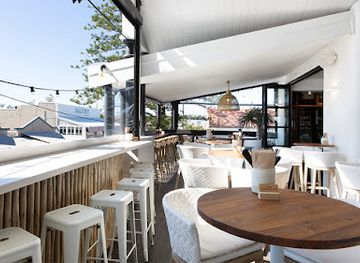
The Balcony Bar & Oyster Co.
Discover fresh oysters and innovative cocktails at The Balcony Bar & Oyster Co., a vibrant culinary gem in Byron Bay, Australia.
-
Bar
Wharf Bar & Restaurant Ballina
Discover fresh seafood and live music at Wharf Bar & Restaurant in Ballina, where stunning river views meet a vibrant atmosphere.


Best nightclubs in Northern Rivers
Evenings in Northern Rivers are concentrated in a few coastal and regional centres rather than spread across a continuous nightlife district. Byron Bay has the broadest choice of pubs, small bars, live-music venues and late-night entertainment, with a busy atmosphere during holiday periods. Brunswick Heads, Ballina, Mullumbimby, Murwillumbah, Lismore and Yamba offer more localised evenings built around pubs, restaurants, breweries, community events and occasional live music. Historic hotels and country pubs remain important social venues inland, while waterfront and seafront establishments are prominent in some coastal towns. Nightclubs exist mainly in the larger visitor centres and their activity can change with seasons, licensing and venue changes, so current arrangements should be checked locally. The region’s evening culture is not limited to drinking: food, theatre, galleries, live performance and small cultural events are significant alternatives, particularly in Lismore, Byron Bay and other creative communities.
-
Night club
Cocktails Nightclub
Discover the vibrant nightlife of Cocktails Nightclub in Surfers Paradise, where exceptional cocktails and electrifying music create unforgettable experiences.
-
Club
Ballina RSL Club
Experience the vibrant energy and community spirit at Ballina RSL Club, where dining, entertainment, and local culture unite.
-
Cocktail bar
Loft Byron Bay
Experience the vibrant atmosphere and expertly crafted cocktails at Loft Byron Bay, your go-to destination for a memorable night out.
-
Pub
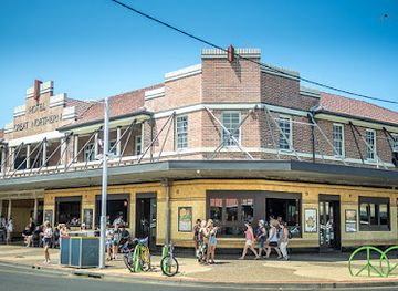
The Northern
Discover the vibrant atmosphere of The Northern, Byron Bay's go-to pub for live music, delicious food, and a true taste of local culture.


Best shops in Northern Rivers
Shopping in Northern Rivers ranges from practical regional high streets to produce markets, independent design stores and craft studios. Byron Bay has the largest concentration of visitor-oriented fashion, homewares, art, books and wellness products, while Bangalow and Mullumbimby are known for smaller-scale independent retail and galleries. Ballina, Lismore, Murwillumbah, Grafton and other country centres provide everyday shops alongside antiques, local art, vintage goods and specialist businesses. Farmers’ markets and community markets are especially useful for macadamias, tropical fruit, preserves, baked goods, coffee and other regional produce, though schedules can change. Pottery, textiles, jewellery, paintings and timber work make more meaningful souvenirs than generic beach merchandise, and many makers sell through galleries or studio outlets rather than permanent visitor centres. The region’s shopping character is strongest when different towns are treated as distinct communities: coastal centres lean towards holiday and lifestyle goods, while inland markets often reveal the agricultural and creative economy.
-
Shopping mall
Pacific Fair Shopping Centre
Explore Pacific Fair Shopping Centre, a vibrant hub of retail, dining, and entertainment in Broadbeach Waters, Queensland.
-
Shopping mall
Harbour Town Premium Outlets
Explore Harbour Town Premium Outlets for unbeatable shopping deals, dining delights, and a vibrant atmosphere on the Gold Coast.
-
Shopping mall
Lismore Square
Discover Lismore Square, the ultimate shopping destination in New South Wales, blending retail, dining, and local culture for an unforgettable experience.
-
Gift shop
Byron Bay Wildlife Sanctuary
Explore Byron Bay Wildlife Sanctuary: A delightful blend of wildlife encounters, café delights, and unique gifts in the heart of New South Wales.


Get your free copy of our complete guide to Northern Rivers, delivered straight to you.
Everything on this page, from attractions and restaurants to essentials and local phrases, in one PDF you can read offline, print or share.
Already have an account? Sign in
Your Northern Rivers guide is ready.
We'll send it to · Not you? Sign out

Getting your guide ready…
We are putting together a fresh copy of the Northern Rivers guide. This can take up to a minute.
This can take a few moments. If your browser asks, choose Allow so the download can start. You'll find the guide in your Downloads folder.
Nothing happened? Download it again
Sorry, the guide is taking longer than usual. Please try again in a minute, or get it by email instead.
Northern Rivers essentials
Currency and Payment
Safety
Emergency Situations
Do's and Don'ts
Local Tips
From Eve
Local phrases worth knowing
You don't need to get them perfect. A few words go a long way, and locals appreciate the effort.
Basics
| English | Local | Say it |
|---|---|---|
| Hello | G’day | [guh-day] |
| Goodbye | See ya | [see yah] |
| Yes | Yep | [yehp] |
| No | Nah | [nah] |
| Please/You're welcome | No worries | [noh wuh-rehz] |
| Thank you | Thanks | [thangs] |
| Excuse me/Sorry | Sorry mate | [sor-ree mayt] |
| How are you? | How’s it going? | [howz it go-ing] |
| Fine. And you? | Good, you? | [guhd, yoo?] |
| Do you speak English? | You speak English? | [yoo speek ing-lish?] |
| I don't understand | I don’t get it | [I don’t get it] |
Eating & Drinking
| English | Local | Say it |
|---|---|---|
| I'd like to see the menu, please | Can I see the menu, please? | [kan I see thuh men-yoo, pleez?] |
| I don't eat meat | I’m a vegetarian | [I’m a ve-ji-tair-ee-an] |
| Cheers! | Cheers! | [cheerz] |
| I would like to pay, please | Can I get the bill, please? | [kan I get thuh bil, pleez?] |
Emergencies
| English | Local | Say it |
|---|---|---|
| Help! | Help! | [help] |
| Go away! | Buzz off! | [buhz off] |
| Call the Police! | Call the cops! | [call thuh cops] |
| Call a doctor! | Get a doctor! | [get a dok-ter] |
| I'm lost | I’m lost | [I’m lost] |
| I'm ill | I’m not well | [I’m not wel] |
Shopping
| English | Local | Say it |
|---|---|---|
| I'd like to buy... | I want to buy... | [I want to buy...] |
| I'm just looking | Just browsing, thanks | [just brow-zing, thangs] |
| How much is it? | What’s the price? | [what’s thuh pryce?] |
| That's too expensive | That’s a bit pricey | [that’s a bit pry-see] |
| Can you lower the price? | Can you bring it down? | [kan yoo bring it down?] |
Time & Numbers
| English | Local | Say it |
|---|---|---|
| What time is it? | What’s the time? | [what’s thuh time?] |
| It's one o'clock | It’s one o’clock | [it’s wun uh-clock] |
| Half past (10) | Half past ten | [half past ten] |
| Morning | Morning | [mor-ning] |
| Afternoon | Arvo | [ar-vo] |
| Evening | Evening | [eev-ning] |
| Yesterday | Yesterday | [yes-ter-day] |
| Today | Today | [to-day] |
| Tomorrow | Tomorrow | [to-mor-row] |
| 1 | One | [wun] |
| 2 | Two | [too] |
| 3 | Three | [three] |
| 4 | Four | [four] |
| 5 | Five | [five] |
| 6 | Six | [six] |
| 7 | Seven | [sev-en] |
| 8 | Eight | [ate] |
| 9 | Nine | [nine] |
| 10 | Ten | [ten] |
Transport & Directions
| English | Local | Say it |
|---|---|---|
| Where's a/the...? | Where’s the...? | [where’s thuh...?] |
| What's the address? | What’s the address? | [what’s thuh ad-dress?] |
| Can you show me (on the map)? | Can you show me on the map? | [kan yoo show me on thuh map?] |
| When's the next (bus)? | When’s the next bus? | [when’s thuh next bus?] |
| A ticket (to ....) | A ticket to... | [a tik-it to...] |
History of Northern Rivers
Aboriginal Country and Cultural Continuity
Northern Rivers lies across several Aboriginal cultural landscapes, including Bundjalung Country through much of the north and centre, with Gumbaynggirr and Yaegl Country important in the southern Clarence Valley. Rivers, coastlines, wetlands, escarpments and food-rich forests supported extensive cultural knowledge and seasonal practice long before European settlement. Sites and place names continue to carry significance, while contemporary Aboriginal organisations, artists and cultural educators maintain living connections to Country. Wollumbin is among the region’s most important cultural landmarks, and its status demonstrates that heritage here is not confined to archaeology or colonial history.
European Exploration and Early Settlement
European maritime exploration along the New South Wales coast preceded sustained inland settlement, which expanded during the nineteenth century as colonial authorities and pastoral interests moved into river valleys. The Richmond, Tweed and Clarence waterways became routes for transport and trade, although river bars, floods and difficult terrain made access challenging. Settlement brought dispossession, violence and profound disruption to Aboriginal communities. The surviving town plans, cemeteries, churches and river ports of the region should therefore be understood within both the development of colonial Australia and the continuing history of its First Peoples.
Timber, Cedar and the Rainforest Frontier
The subtropical forests of the Northern Rivers attracted cedar cutters during the nineteenth century. Red cedar was highly valued for building and furniture, and logs were moved along creeks and rivers towards coastal ports. Timber getting opened routes into dense rainforest but caused extensive ecological change and frequently relied on the coercion and displacement of Aboriginal people. Remnant big trees, old forest roads, sawmill traces and protected rainforest areas preserve fragments of this era. Later conservation movements helped secure national parks and changed public attitudes towards the region’s forests.
Dairy, Sugar and Agricultural Growth
After the timber boom, dairy farming became a major economic force across the Tweed, Richmond and Clarence valleys. Small farms, butter factories and cooperative networks shaped both settlement patterns and local identity, while sugar cane became especially important in the warmer coastal districts around the Tweed and Clarence. Tropical fruit, bananas, macadamias and other crops later diversified the agricultural base. Many inland views today still reflect this history: cleared hills, cane fields, dairy country, farm lanes and river flats form a working landscape rather than simply a scenic backdrop.
River Ports, Railways and Regional Towns
Coastal bars and navigable rivers made ports such as Ballina, Yamba and other Clarence and Richmond settlements important links between farms, timber districts and wider markets. Railways gradually connected inland towns to the coast and to the national network, supporting the movement of produce and passengers. Lismore grew as a commercial and administrative centre, while Murwillumbah developed around the productive Tweed Valley. Although many services have since changed, the region’s town centres, wharves, railway remnants and broad civic streets still reveal how strongly transport shaped Northern Rivers society.
The Rise of Coastal Tourism
From the twentieth century, improved roads, private cars and domestic holidays transformed the coast. Byron Bay, formerly associated with shipping, agriculture and whaling-related industries, became increasingly known for surfing, beach holidays and later arts, wellness and creative enterprises. Ballina, the Tweed Coast, Yamba and smaller beach settlements also expanded their visitor economies. Tourism brought employment and investment but also housing pressure, seasonal congestion and debates over environmental limits. The region’s contemporary character reflects this mixture of established communities, agricultural towns and rapidly changing coastal destinations.
Environmental Protection and Community Resilience
The protection of rainforest, wetlands, coastal dunes and estuaries became an increasingly important regional movement during the late twentieth century. National parks such as Border Ranges, Nightcap and Bundjalung conserve different parts of the landscape, while community groups have worked on habitat restoration, river health and threatened species. The 2017–19 drought and bushfires, followed by severe flooding in 2022, demonstrated the region’s exposure to climate and weather extremes. Recovery efforts continue to influence planning, transport, housing and the way visitors are asked to use natural areas.
Northern Rivers in Photos
Browse through our photo collection highlighting the charm and character of the destination.
Neighbouring regions of Northern Rivers
The closest regions to Northern Rivers, if you have time for more than one.
-

-

-

-

-


Swipe for more regions
Explore more

Explore more of Australia
Discover the diverse landscapes, vibrant cities, and unique wildlife of Australia, a captivating destination offering endless adventures and unforgettable experiences.
Explore Australia