

Free Vaca Plateau Travel Guide & Mobile App
Explore Vaca Plateau with free travel guides. Discover regional history, expert tips, proposed trips, and audio guides on web or mobile app.


Vaca Plateau travel combines Caracol’s Maya monuments, remote rainforest, caves and wildlife in Belize’s rugged western interior.
Read more about Vaca Plateau
When is the best time to visit Vaca Plateau?
Best: January–March · 26–28°C| Month | High (°C) | Rainfall (mm) |
|---|---|---|
| January (best) | 26 | 62 |
| February (best) | 26 | 57 |
| March (best) | 28 | 65 |
| April | 30 | 77 |
| May | 32 | 123 |
| June | 32 | 181 |
| July | 32 | 176 |
| August | 32 | 199 |
| September | 32 | 234 |
| October | 30 | 223 |
| November | 28 | 140 |
| December | 26 | 84 |
Getting to and around Vaca Plateau
How to get there
Transportation
Best attractions in Vaca Plateau
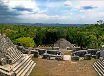
The Vaca Plateau’s attractions are concentrated around archaeology and protected forest rather than a network of towns or commercial visitor facilities. Caracol is the central experience, with monumental plazas, temples, reservoirs, carved monuments and causeways spread through the woodland. Caana provides the most commanding architectural viewpoint, while the scale of the surrounding settlement reveals that the site was once a major Maya urban centre rather than a single ceremonial ruin. The journey itself passes through increasingly remote forest and offers opportunities for birdwatching and wildlife observation, although sightings are unpredictable. Limestone terrain, caves and seasonal watercourses add geological interest, but cave visits should be undertaken only where access is authorised and properly guided. The wider Chiquibul forest landscape supports ecological interpretation and quiet walking, subject to conservation rules and road conditions. Visitors seeking a broad programme of restaurants, museums or family attractions will find little on the plateau; those facilities are concentrated in gateway settlements outside the region, especially San Ignacio. The area’s appeal lies in the combination of monumental archaeology, remoteness and a living tropical environment.
-
Archaeological site
Xunantunich Mayan Ruins
Discover the majestic Xunantunich Mayan Ruins and immerse yourself in the ancient Mayan civilization's captivating history and breathtaking landscapes.
-
National reserve
Cahal Pech Archaeological Reserve
Discover the ancient Maya civilization at Cahal Pech Archaeological Reserve in Belize, where history meets breathtaking landscapes.
-
National reserve
Nohoch Che'en Caves Branch Archaeological Reserve
Uncover the wonders of the Nohoch Che'en Caves Branch Archaeological Reserve, a blend of adventure and cultural heritage in Belize's lush landscapes.
-
Tourist attraction
Rio On Pools
Explore the stunning natural beauty of Rio On Pools in Belize, where cascading waterfalls and serene pools create a perfect getaway.


Best landmarks in Vaca Plateau
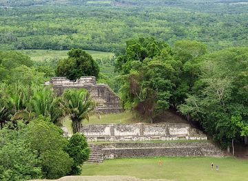
Caracol is the defining landmark of the Vaca Plateau and one of the most important ancient Maya sites in Belize. Its great civic and ceremonial core extends across forested terrain, with monumental plazas and temples expressing the power of a kingdom that competed with Tikal and Naranjo. Caana is the most recognisable structure: its high stepped mass rises above the canopy and remains a powerful reminder of the city’s scale. The site’s causeways, reservoirs and carved monuments are equally significant because they show how architecture, water management and political communication worked together in a large tropical settlement. Beyond the ruins, the plateau’s forested limestone environment is itself an important geographical landmark, characterised by karst formations, caves and remote watersheds rather than dramatic urban architecture. These natural features should be viewed as part of a protected landscape, not as unregulated recreation sites. The combination of monumental Maya construction and dense forest gives the Vaca Plateau its distinctive visual and historical identity.
-
Archaeological site
Xunantunich Mayan Ruins
Explore the ancient Xunantunich Mayan Ruins in Belize, a breathtaking archaeological site showcasing rich history and stunning natural beauty.
-
National reserve
Cahal Pech Archaeological Reserve
Discover the ancient Mayan ruins and breathtaking views at Cahal Pech Archaeological Reserve in San Ignacio, Belize.
-
Archaeological site
Lamanai Archaeological Reserve
Explore the ancient Maya ruins of Lamanai Archaeological Reserve, a captivating blend of history, nature, and adventure in Belize.
-
Tourist attraction
Great Blue Hole
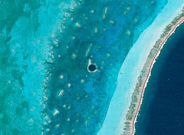
Discover the breathtaking depths of the Great Blue Hole, a UNESCO World Heritage Site and a premier diving destination in Belize.


Explore Vaca Plateau on the map
Plan your trip on one map. See where the top cities, national parks and sights are, and book hotels and experiences in a few clicks.
Best hotels in Vaca Plateau
Best restaurants in Vaca Plateau
The Vaca Plateau has almost no independent restaurant scene, so visitors should eat beforehand or carry a packed meal arranged in San Ignacio or another gateway settlement outside the region. Dining in the wider Cayo area reflects Belize’s multicultural food traditions, with rice and beans, stewed meats, chicken, fresh fruit, tortillas and hearty roadside or family-style cooking commonly available before or after a plateau excursion. Gateway eateries may also offer local Maya-influenced dishes and ingredients from the inland countryside, but particular menus and businesses can change. There are no established dining streets or dependable café clusters at Caracol, and visitors should not rely on finding provisions after entering the forest. A practical day-trip meal should be portable, well packed and accompanied by ample drinking water; all rubbish should be removed from the archaeological and forest areas. The remote setting makes preparation more important than culinary variety.
-
Restaurant
The Guava Limb Restaurant & Café
Experience delightful Belizean flavors at The Guava Limb Restaurant & Café in San Ignacio, where fresh ingredients meet vibrant ambiance.
-
Restaurant
Ella's Restaurant/cool spot
Experience authentic Belizean flavors at Ella's Restaurant in Hopkins - where delicious food meets a warm atmosphere.
-
Restaurant
Caladium Restaurant
Experience authentic Belizean cuisine at Caladium Restaurant in Belmopan - a culinary delight for all visitors.
-
Restaurant
Corkers Restaurant and Wine Bar
Experience exceptional dining at Corkers Restaurant and Wine Bar in Belmopan, where local flavors meet fine wines for an unforgettable culinary journey.


Best bars in Vaca Plateau
The Vaca Plateau has no meaningful nightlife infrastructure, and visiting it is a daytime activity dictated by the long approach, daylight and road conditions. There are no established bar or nightclub districts on the plateau, while evening entertainment is limited to the gateway communities outside it. San Ignacio provides the nearest wider choice of restaurants, traditional bars, casual evening venues and occasional live music, with the exact scene changing according to the town’s current businesses and events. Visitors staying in forest lodges or rural accommodation near the approach may find a quiet evening centred on dinner, conversation and the surrounding landscape rather than organised entertainment. Alcohol should not be treated as part of the plateau excursion, particularly when travelling on demanding roads or walking around archaeological structures. Arrange the return journey before departure and avoid assuming that a late-night transport service will be available in this remote area.
-
Grill
Palapa Bar and Grill
Experience the vibrant flavors and rhythms of Belize at Palapa Bar and Grill, where live music and delicious grilled dishes await.
-
Grill
Tipsy Tuna
Experience the vibrant flavors and lively atmosphere at Tipsy Tuna in Placencia, a top destination for grill lovers and beachgoers.
-
Grill
Barefoot Beach Bar
Experience the vibrant atmosphere and unique flavors at Barefoot Beach Bar, a must-visit spot on the stunning Placencia Sidewalk.
-
Sports bar
Mike's Cue Club.Bar & Restaurant
Discover the lively atmosphere at Mike's Cue Club, Belmopan's premier sports bar, offering great food, drinks, and entertainment.


Best nightclubs in Vaca Plateau
The Vaca Plateau has no meaningful nightlife infrastructure, and visiting it is a daytime activity dictated by the long approach, daylight and road conditions. There are no established bar or nightclub districts on the plateau, while evening entertainment is limited to the gateway communities outside it. San Ignacio provides the nearest wider choice of restaurants, traditional bars, casual evening venues and occasional live music, with the exact scene changing according to the town’s current businesses and events. Visitors staying in forest lodges or rural accommodation near the approach may find a quiet evening centred on dinner, conversation and the surrounding landscape rather than organised entertainment. Alcohol should not be treated as part of the plateau excursion, particularly when travelling on demanding roads or walking around archaeological structures. Arrange the return journey before departure and avoid assuming that a late-night transport service will be available in this remote area.
-
Lounge
Desire Lounge
Experience the ultimate relaxation and delightful flavors at Desire Lounge, Belmopan's go-to spot for casual dining and vibrant nightlife.
-
Casino
MONETA Night Club and Casino
Discover excitement and entertainment at MONETA Night Club and Casino, the ultimate nightlife destination in San Pedro.
-
Bar
Revolution Nightclub
Dive into the nightlife at Revolution Nightclub, San Ignacio's premier dance destination featuring music, cocktails, and a vibrant atmosphere.
-
Night club
Tequila Night Club
Discover the vibrant nightlife of Red Creek at Tequila Night Club, where great music, lively vibes, and unforgettable moments await you.

Best shops in Vaca Plateau
Shopping on the Vaca Plateau is effectively limited to practical provisions arranged before departure, and there are no substantial retail streets, craft markets or shopping centres at Caracol. Visitors should buy water, snacks, insect repellent, sun protection and other necessities in San Ignacio or another gateway settlement outside the region. The wider Cayo area offers independent shops, food outlets, small markets and craft sellers where travellers may find Belizean food products, locally made souvenirs, woodwork, textiles or other handmade items, although stock and trading days vary. Purchases connected with Maya heritage should be made through reputable, authorised sellers rather than from anyone offering archaeological objects or unverified antiquities. Do not remove stones, pottery, plants or other material from the plateau, and avoid buying items that may have been taken from protected sites. For this destination, responsible preparation and support for legitimate local businesses matter more than browsing for souvenirs on location.
-
Gift shop
Art Box - Belize Artisan Store & Cafe
Explore the vibrant craft, art, and culinary delights of Belize at Art Box - your creative sanctuary in Belmopan.
-
Stationery store
A&R Enterprises | Belmopan
Explore A&R Enterprises in Belmopan: A vibrant stationery and department store offering a unique shopping experience for tourists.
-
Art gallery
GariMaya Gift Shop
Explore GariMaya Gift Shop: A vibrant art gallery showcasing Belizean craftsmanship and unique local artworks for tourists and art lovers alike.
-
Department store
Dibary Belmopan
Explore Dibary Belmopan for a unique shopping experience featuring local crafts, fashion, and essentials in the heart of Belize.


Get your free copy of our complete guide to Vaca Plateau, delivered straight to you.
Everything on this page, from attractions and restaurants to essentials and local phrases, in one PDF you can read offline, print or share.
Already have an account? Sign in
Your Vaca Plateau guide is ready.
We'll send it to · Not you? Sign out

Getting your guide ready…
We are putting together a fresh copy of the Vaca Plateau guide. This can take up to a minute.
This can take a few moments. If your browser asks, choose Allow so the download can start. You'll find the guide in your Downloads folder.
Nothing happened? Download it again
Sorry, the guide is taking longer than usual. Please try again in a minute, or get it by email instead.
Vaca Plateau essentials
Currency and Payment
Safety
Emergency Situations
Do's and Don'ts
Local Tips
From Eve
Local phrases worth knowing
You don't need to get them perfect. A few words go a long way, and locals appreciate the effort.
Basics
| English | Local | Say it |
|---|---|---|
| Hello | B'alam | [Bah-lahm] |
| Goodbye | K'uxi | [Koo-shee] |
| Yes | Aye | [Aye] |
| No | Ma | [Mah] |
| Please/You're welcome | T'ux | [Tooksh] |
| Thank you | Yuk'ul | [Yook-ool] |
| Excuse me/Sorry | Ma' k'uxi | [Mah koo-shee] |
| How are you? | B'ix a k'ux? | [Beech ah koo-sh?] |
| Fine. And you? | K'uxi. B'ix a k'ux? | [Koo-shee. Beech ah koo-sh?] |
| Do you speak English? | A' k'ux a b'een English? | [Ah koo-ex ah been English?] |
| I don't understand | Ma' a k'uxi | [Mah ah koo-shee] |
Eating & Drinking
| English | Local | Say it |
|---|---|---|
| I'd like to see the menu, please | In k'ux a k'uch'ul menu, t'ux | [In koo-ex ah koo-chool menu, tooksh] |
| I don't eat meat | Ma' in k'uch'ul x'ek' | [Mah in koo-chool shek'] |
| Cheers! | B'alam! | [Bah-lahm!] |
| I would like to pay, please | In k'ux a k'uch'ul, t'ux | [In koo-ex ah koo-chool, tooksh] |
Emergencies
| English | Local | Say it |
|---|---|---|
| Help! | T'ux | [Tooksh] |
| Go away! | K'uxi! | [Koo-shee!] |
| Call the Police! | K'uxi a' k'uch'ul Policía! | [Koo-shee ah' koo-chool Police-ah!] |
| Call a doctor! | K'uxi a' k'uch'ul médico! | [Koo-shee ah' koo-chool may-dee-co!] |
| I'm lost | In k'ux a k'uch'ul | [In koo-ex ah koo-chool] |
| I'm ill | In k'ux a k'uch'ul k'uxi | [In koo-ex ah koo-chool koo-shee] |
Shopping
| English | Local | Say it |
|---|---|---|
| I'd like to buy... | In k'ux a b'ik'... | [In koo-ex ah beek'...] |
| I'm just looking | In k'ux k'uch'ul | [In koo-ex koo-chool] |
| How much is it? | B'ix k'ux a b'ik'? | [Beech koo-sh ah beek'?] |
| That's too expensive | K'a k'ux a b'ik' k'uxi | [Kah koo-sh ah beek' koo-shee] |
| Can you lower the price? | A' k'ux a b'ik' k'uxi? | [Ah koo-ex ah beek' koo-shee?] |
Time & Numbers
| English | Local | Say it |
|---|---|---|
| What time is it? | B'ix k'ux a t'aan? | [Beech koo-sh ah tan?] |
| It's one o'clock | K'uxi b'een t'aan | [Koo-shee been tan] |
| Half past (10) | K'uxi ja' k'ux (10) | [Koo-shee hah koo (10)] |
| Morning | K'iy | [Kee] |
| Afternoon | K'i'ik' | [Kee-eek'] |
| Evening | K'ik' | [Kee-k'] |
| Yesterday | K'i'ik' k'uxi | [Kee-eek' koo-shee] |
| Today | B'ix a k'ux | [Beech ah koo-sh] |
| Tomorrow | B'ix k'ux a' k'ux | [Beech koo-ex ah' koo-sh] |
| 1 | B'een | [Been] |
| 2 | Ka' | [Kah] |
| 3 | Oxl | [Oxl] |
| 4 | Wuk' | [Wook'] |
| 5 | Wuk' b'een | [Wook' been] |
| 6 | Wuk' ka' | [Wook' kah] |
| 7 | Wuk' oxl | [Wook' oxl] |
| 8 | Wuk' wuk' | [Wook' wook'] |
| 9 | Wuk' b'een ka' | [Wook' been kah] |
| 10 | Wuk' b'een oxl | [Wook' been oxl] |
Transport & Directions
| English | Local | Say it |
|---|---|---|
| Where's a/the...? | K'uxi a ...? | [Koo-shee ah ...?] |
| What's the address? | B'ix k'ux a t'aan? | [Beech koo-sh ah tan?] |
| Can you show me (on the map)? | A' k'ux a k'uch'ul (ka'ab)? | [Ah koo-ex ah koo-chool (kah-ab)?] |
| When's the next (bus)? | B'ix k'ux a k'uch'ul (bus)? | [Beech koo-sh ah koo-chool (bus)?] |
| A ticket (to ....) | In k'ux a b'ik' (to ...) | [In koo-ex ah beek' (to ...)] |
History of Vaca Plateau
Early Maya Settlement on the Plateau
The Vaca Plateau formed part of the southern lowland Maya world, where communities used the region’s limestone terrain, forests and water-management possibilities for settlement. Archaeological evidence at Caracol indicates that occupation began well before the city reached its later prominence. The plateau’s relationship with nearby river valleys and upland resources helped support a substantial population in an environment that could experience marked dry seasons. Ancient Maya inhabitants altered the landscape through reservoirs, causeways, terraces and monumental construction, leaving an urban and agricultural footprint that remains visible in the archaeological reserve.
Caracol’s Rise during the Classic Period
From the third century AD, Caracol developed into a major Maya centre, reaching its greatest political and architectural influence during the Classic period. Its rulers built large plazas, temples, palaces, reservoirs and an extensive network of causeways linking the central city with outlying settlements. The scale of the urban area suggests a densely organised society rather than an isolated ceremonial site. Caracol’s location on the Vaca Plateau placed it within a strategic zone connecting the Maya Mountains, the interior lowlands and routes towards present-day Guatemala.
War and Rivalry with Tikal
Caracol became deeply involved in the political struggles of the central Maya lowlands. In AD 562, its ruler Yajaw Te’ K’inich II defeated Tikal, a powerful kingdom across the modern border in Guatemala, an event recorded in Maya inscriptions. Caracol later fought Naranjo and other regional powers, extending its influence through military alliances and political control. These conflicts are important because they show that the city was a substantial state with ambitions extending far beyond the plateau. Carved monuments and architectural remains preserve evidence of this period of regional competition.
Late Maya Transformation and Abandonment
Caracol remained occupied for centuries after its political high point, but the wider Maya world underwent major changes during the late Classic and Terminal Classic periods. Monumental construction and the recording of royal histories eventually declined, while parts of the urban system were reduced or abandoned. As elsewhere in the Maya lowlands, this was not a single sudden event affecting every inhabitant at once; population and political authority changed over time. Forest gradually reclaimed many structures, helping preserve the city until modern archaeological work brought its scale and history to wider attention.
Modern Archaeological Research at Caracol
Systematic archaeological investigation at Caracol expanded during the twentieth century and continues to refine understanding of the site. Researchers have mapped extensive settlement, studied inscriptions and excavated major structures, including Caana and surrounding plazas. The work transformed Caracol from a remote forest ruin into one of Belize’s principal archaeological places while also revealing the complexity of ancient Maya urban life. Conservation remains challenging because of forest growth, tropical weather and the size of the site, and many structures still form part of an archaeological landscape rather than a fully excavated city.
Forest Protection and the Vaca Landscape
In the modern era, the plateau has been shaped by conservation of Belize’s interior forests and by efforts to protect archaeological resources from looting, uncontrolled development and environmental damage. Caracol lies within a remote protected landscape associated with the Chiquibul forest system, where archaeological stewardship and biodiversity protection overlap. The area’s forests, caves and watersheds are valuable in their own right, while the restricted infrastructure that limits easy access also helps retain the plateau’s secluded character. Tourism is therefore managed around guided visits, road access and the protection of cultural and natural resources.
Vaca Plateau in Photos
Browse through our photo collection highlighting the charm and character of the destination.
Neighbouring regions of Vaca Plateau
The closest regions to Vaca Plateau, if you have time for more than one.
-

-

-

-
-


Swipe for more regions
Explore more
Explore more of Belize
Discover Belize: A Caribbean paradise known for its stunning barrier reef, rich cultural heritage, and eco-friendly adventures in lush rainforests and pristine waters.
Explore Belize