Sage Mountain National Park Travel Guide - Free Web & App
Your ultimate guide to Sage Mountain National Park. Discover top landmarks, proposed trips, and local tips. Free on the web or via the Evendo companion app.


Sage Mountain National Park in the British Virgin Islands reveals Tortola’s highest peak, rainforest trails, native wildlife and Caribbean island views.
Mountain Landscapes and Forest
Sage Mountain National Park occupies 92 acres on the central ridge of Tortola, the largest island in the British Virgin Islands. Rising to about 523 metres, Sage Mountain is the territory’s highest point, although the park is better understood as a compact upland forest landscape than as a high-altitude mountain destination. Its trails pass through moist tropical woodland, including stands of West Indian mahogany, white cedar and other native vegetation, with tree ferns and dense undergrowth giving the interior a cooler, quieter character than Tortola’s coastal settlements. The terrain is steep in places, and paths can become slippery after rain.Read more about Sage Mountain National Park
Wildlife and Conservation
Exploring the Park
When is the best time to visit Sage Mountain National Park?
Best: June–August · 29°C| Month | High (°C) | Rainfall (mm) |
|---|---|---|
| January | 28 | 80 |
| February | 28 | 70 |
| March | 28 | 60 |
| April | 28 | 50 |
| May | 29 | 40 |
| June (best) | 29 | 30 |
| July (best) | 29 | 30 |
| August (best) | 29 | 30 |
| September | 29 | 40 |
| October | 29 | 50 |
| November | 28 | 60 |
| December | 28 | 70 |
Getting to and around Sage Mountain National Park
How to get there
Transportation
Best attractions in Sage Mountain National Park
The principal attraction is the forest itself, experienced along trails that climb through Tortola’s central uplands and pass through native woodland, West Indian mahogany stands and areas of dense tropical vegetation. Sage Mountain, the territory’s highest summit, provides the park’s defining setting, while clearings and elevated points can reveal neighbouring islands and the Caribbean Sea between trees and changing cloud. Birdwatching is rewarding for patient visitors, with pearly-eyed thrashers, bananaquits and other island species associated with the forest, although sightings are seasonal and never guaranteed. Interpretive signs and National Parks Trust information help visitors understand the park’s plants, wildlife and conservation role. Because Sage Mountain National Park is compact and lightly developed, there are no clusters of museums, shops or built amusements within its boundaries; its appeal lies in walking, observing the upland habitat and experiencing a cooler, quieter side of Tortola. Road Town and the island’s coastal attractions can be combined with the park as part of a wider Tortola itinerary.
Best landmarks in Sage Mountain National Park
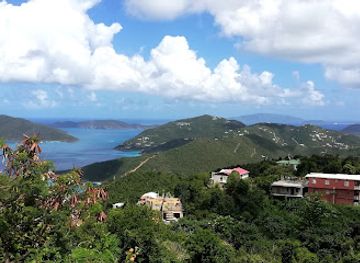
Sage Mountain is the central natural landmark of the park and the highest point in the British Virgin Islands, rising above Tortola’s deeply indented coastline and revealing the island’s mountainous structure. The surrounding upland forest is equally significant: its moister conditions support native trees, birds and understorey plants that are less evident on the developed and drier coastal slopes. West Indian mahogany trees are an important visual feature of the woodland, while the park’s ridgeline and clearings provide views towards Tortola’s bays and neighbouring islands when weather and vegetation allow. The national park designation itself is a landmark in the territory’s conservation history, since Sage Mountain was the British Virgin Islands’ first national park. Unlike many island visitor attractions, it has few architectural monuments; its importance lies in the relationship between the highest ground, surviving forest habitat, watershed protection and the wider environmental identity of Tortola.
Explore Sage Mountain National Park on the map
Plan your trip on one map. See where the top attractions, landmarks, restaurants and hotels are, and book hotels and experiences in a few clicks.
Best hotels in Sage Mountain National Park
Get your free copy of our complete guide to Sage Mountain National Park, delivered straight to you.
Everything on this page, from attractions and restaurants to essentials and local phrases, in one PDF you can read offline, print or share.
Already have an account? Sign in
Your Sage Mountain National Park guide is ready.
We'll send it to · Not you? Sign out

Getting your guide ready…
We are putting together a fresh copy of the Sage Mountain National Park guide. This can take up to a minute.
This can take a few moments. If your browser asks, choose Allow so the download can start. You'll find the guide in your Downloads folder.
Nothing happened? Download it again
Sorry, the guide is taking longer than usual. Please try again in a minute, or get it by email instead.
Sage Mountain National Park essentials
Currency and Payment
Safety
Emergency Situations
Do's and Don'ts
Local Tips
From Eve
Local phrases worth knowing
You don't need to get them perfect. A few words go a long way, and locals appreciate the effort.
Basics
| English | Local | Say it |
|---|---|---|
| Hello | Good day | [gud dey] |
| Goodbye | Farewell | [fehr-wel] |
| Yes | Aye | [aye] |
| No | Nay | [nay] |
| Please/You're welcome | If you please | [if yu pleez] |
| Thank you | Thank ye | [thangk yee] |
| Excuse me/Sorry | Beg yer pardon | [beg yer pahr-dun] |
| How are you? | How are ye? | [how are yee] |
| Fine. And you? | I'm well. And yerself? | [ahym wel. and yur-self] |
| Do you speak English? | Do ye speak English? | [doo yee speek ing-glish] |
| I don't understand | I dinna ken | [ah din-uh ken] |
Eating & Drinking
| English | Local | Say it |
|---|---|---|
| I'd like to see the menu, please | I'd like to see the bill o' fare, if ye please | [ahyd like to see the bil o' fayr, if yee pleez] |
| I don't eat meat | I dinna eat flesh | [ah din-uh eet flesh] |
| Cheers! | Sláinte! | [slahn-chuh] |
| I would like to pay, please | I'd like to settle the bill, if ye please | [ahyd like to set-l the bil, if yee pleez] |
Emergencies
| English | Local | Say it |
|---|---|---|
| Help! | Help! | [help] |
| Go away! | Begone! | [bee-gon] |
| Call the Police! | Summon the Constabulary! | [sum-muhn the con-stab-yuh-lar-ee] |
| Call a doctor! | Fetch a sawbones! | [fetch a saw-bonz] |
| I'm lost | I'm fair flummoxed | [ahm fair flum-moxed] |
| I'm ill | I'm feeling poorly | [ahm feeling poor-lee] |
Shopping
| English | Local | Say it |
|---|---|---|
| I'd like to buy... | I'd like to purchase... | [ahyd like to pur-chess] |
| I'm just looking | I'm just browsing | [ahym just brow-zing] |
| How much is it? | How much is that? | [how much is that] |
| That's too expensive | That's too dear | [thats too dear] |
| Can you lower the price? | Can ye drop the price? | [can yee drop the price] |
Time & Numbers
| English | Local | Say it |
|---|---|---|
| What time is it? | What's the hour? | [whats the our] |
| It's one o'clock | It's one of the clock | [its one of the clock] |
| Half past (10) | Half ten | [half ten] |
| Morning | Mornin' | [morn-in] |
| Afternoon | Afternoon | [after-noon] |
| Evening | Evenin' | [even-in] |
| Yesterday | Yestermorn | [yest-er-morn] |
| Today | This day | [this day] |
| Tomorrow | Morrow | [morr-oh] |
| 1 | One | [wun] |
| 2 | Two | [too] |
| 3 | Three | [three] |
| 4 | Four | [for] |
| 5 | Five | [fiv] |
| 6 | Six | [siks] |
| 7 | Seven | [sev-en] |
| 8 | Eight | [ayt] |
| 9 | Nine | [nine] |
| 10 | Ten | [ten] |
Transport & Directions
| English | Local | Say it |
|---|---|---|
| Where's a/the...? | Whaur's the...? | [wharz the] |
| What's the address? | What's the addy? | [whats the addy] |
| Can you show me (on the map)? | Can ye show me (on the map)? | [can yee show me (on the map)] |
| When's the next (bus)? | When's the next (bus)? | [whens the next (bus)] |
| A ticket (to ....) | A billet (ta ....) | [a bil-let (ta)] |
History of Sage Mountain National Park
A Volcanic Island Foundation
Tortola is part of the mountainous Virgin Islands, a group shaped by ancient volcanic activity, uplift and erosion rather than by a single recent geological event. Sage Mountain occupies the island’s elevated central spine, where higher rainfall and cloud cover support a moister environment than the dry coastal slopes. The mountain’s height and watershed value helped preserve a forest landscape that is markedly different from the beaches, scrub and settled shorelines for which the British Virgin Islands are more widely known.
Early Settlement and Land Use
Long before the British colonial period, Indigenous peoples travelled through and settled parts of the Virgin Islands, using the islands’ coastal and upland resources. Later, Tortola’s valleys and lower slopes were more extensively transformed by plantation agriculture, particularly sugar cultivation, while steep central ground remained comparatively difficult to clear and farm. The surviving upland forest therefore reflects both natural conditions and the uneven history of land use across Tortola, where accessible valleys experienced more intensive development than the mountain ridge.
Protected as a National Park
Sage Mountain became the first national park in the British Virgin Islands in 1964. Its protection marked an important shift towards conserving Tortola’s native forest and safeguarding land above the island’s settlements and agricultural areas. The park is managed within the territory’s wider protected-area system by the National Parks Trust, whose work includes conservation, visitor education and the maintenance of natural and historic sites. The designation also established Sage Mountain as a place where residents and visitors could encounter the island’s remaining upland woodland.
Contemporary Conservation
Modern Sage Mountain is valued for biodiversity, watershed protection, scientific interest and low-impact recreation. Hurricanes, invasive species, drought, changing rainfall and pressure from development remain relevant concerns for Caribbean island forests, making careful management particularly important. Trails and interpretive material allow access without treating the woodland as a heavily built visitor attraction. Today, the park forms part of Tortola’s environmental identity: a protected interior landscape visited from the island’s coastal communities rather than a separate settlement or resort area.
Sage Mountain National Park in Photos
Browse through our photo collection highlighting the charm and character of the destination.
Neighbouring destination travel guides
The closest destinations to Sage Mountain National Park, if you have time for more than one.
-

-

-
-
-


Swipe for more destinations