Background

Det Falsterske Dige

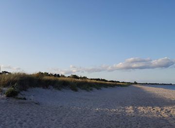
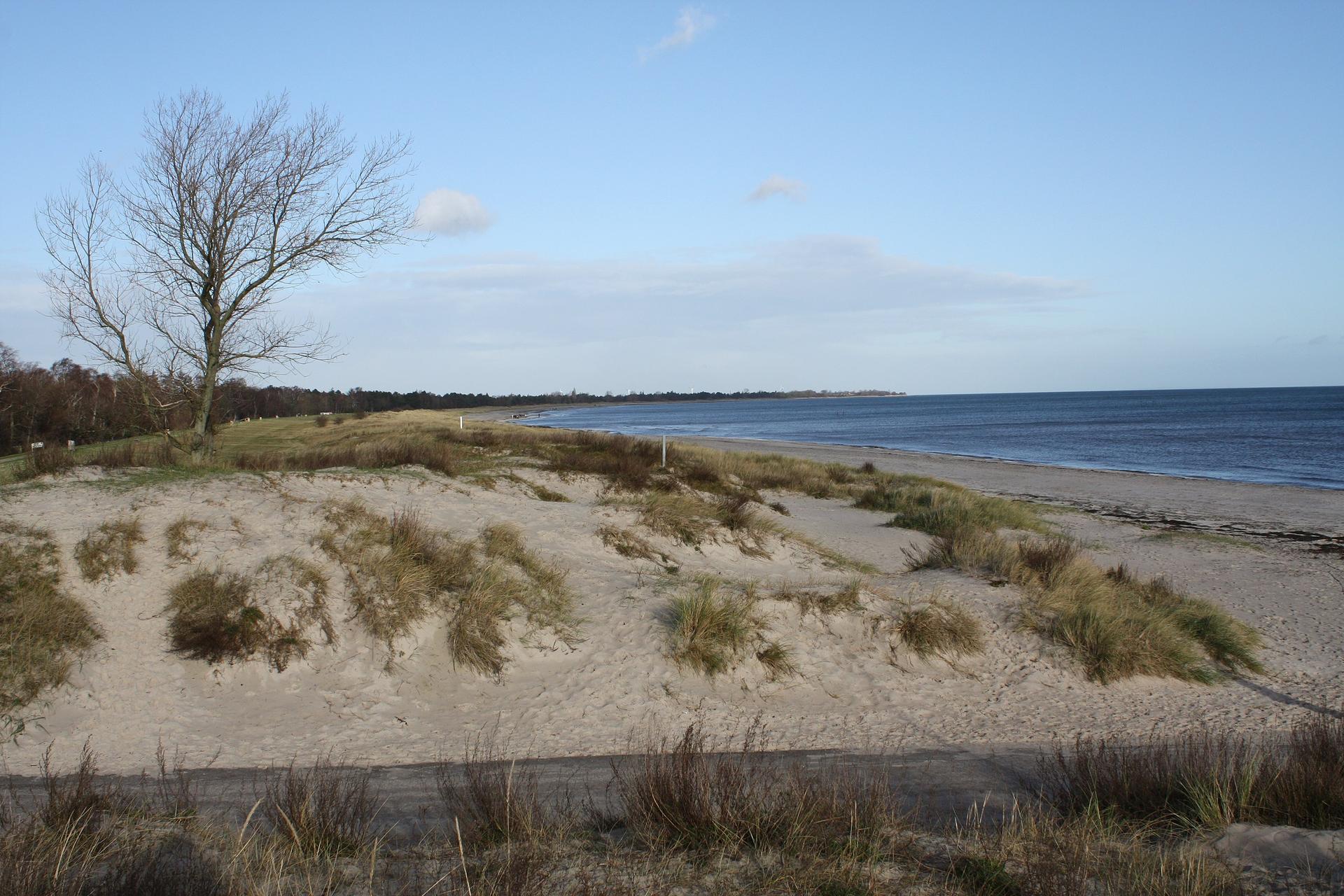
Long, low and windswept, Det Falsterske Dige is Falster’s coastal backbone: a working sea wall that doubles as a tranquil walking and cycling route with wide Baltic views.

4.6

A Sea Wall Shaping the Coast of Falster

Det Falsterske Dige is more than a pleasant coastal path: it is a substantial flood defence stretching for many kilometres along Falster’s exposed Baltic shore. Built to protect low-lying fields, villages and later the growing holiday area around Marielyst, the dike has subtly but decisively shaped how people live with the sea here. Behind it lie reclaimed meadows and agricultural land lying only a few metres above sea level, while on the seaward side the beach, dunes and waves absorb the Baltic’s restless energy. Walking along the broad crest, you can read this story in the landscape itself. On stormy days the wind whips across from the water, making it easy to imagine the surges that once flooded this coast and prompted the construction of the barrier. On calm summer evenings, the same structure feels almost invisible, blending into the dunes and long, pale beach that draws visitors from across Denmark.

Coastal Landscapes and Baltic Horizons

From the top of the dike, the views are characteristically big and horizontal. To the east the Baltic Sea stretches out, often in muted tones of grey-blue, with sandbars and shallow water creating subtle bands of colour. Gulls wheel overhead, and in migration seasons you may spot skeins of geese and waders moving purposefully along the flyway. The soundscape is dominated by surf and wind, punctuated now and then by distant voices from the beach or the rustle of grasses. Turn inland and the atmosphere shifts completely. Here the dike frames a quieter countryside: fields striped with crops, drainage channels cutting geometric lines through the flat terrain, and clusters of holiday cottages around Marielyst. In some places, small patches of wet meadow and reeds attract songbirds and occasional herons, adding a softer, wilder note to an otherwise heavily managed landscape.

A Straight Line Made for Walking and Cycling

The dike’s gently undulating track makes it an inviting route for walkers, joggers and cyclists looking for level ground and uninterrupted sea air. Sections near Marielyst are especially popular for casual strolls at sunrise or sunset, when the light slants low over the water and the beach below begins to empty. The grass or gravel surface is generally easy underfoot, though exposed to weather; on windy days you feel every gust, and in winter the chill can be biting. Because the route runs along the top of the flood defence, there are frequent opportunities to drop down to the beach or inland roads and then rejoin the dike further along. This creates flexible out‑and‑back or loop walks, whether you want a brief leg-stretch or a half‑day outing. Benches are scarce, but the wide crest itself often serves as an impromptu picnic spot.

Engineering, Maintenance and Coastal Change

Det Falsterske Dige is actively managed, with local authorities and dike associations responsible for ensuring that the structure withstands heavy seas and public use. Vegetation on the slopes is kept low to protect the integrity of the embankment, and surfacing is periodically improved where foot traffic is heaviest. The dike must balance its protective role with regulations on nature protection, ensuring that people can enjoy the route without damaging dune systems or bird habitats. Along its length you can see subtle signs of this ongoing work: repaired sections where storms have bitten into the seaward toe, upgraded surfacing on the path, or fenced areas where sensitive dunes are being allowed to recover. In some stretches, beach nourishment projects have widened the sandy shore in front of the dike, reminding visitors that this coastline is still changing, and that the wall is one chapter in a longer story of human adaptation to the sea.

A Quiet Counterpoint to Busy Marielyst

While Marielyst itself buzzes in summer with ice-cream kiosks, family attractions and beach activities, the dike provides a quieter counterpoint only a short walk away. Climb up from the resort streets and you are suddenly in a linear landscape of big skies and open wind, where the main company is dog walkers, cyclists and the occasional kite surfer visible out on the water. This contrast is part of the appeal: you can spend the morning amid the bustle of the resort, then escape to the dike for an hour of sea breeze and horizon-gazing. Even in peak season, it is usually easy to find a section where the only sounds are waves and wind in the grass, making Det Falsterske Dige a valuable breath of space along one of Denmark’s most visited holiday coasts.

Local tips

  • Aim for early morning or late evening walks for softer light, fewer people near Marielyst and the best chance of spotting birds along the shore and fields.
  • Pack a windproof layer even in summer; the exposed crest of the dike can feel significantly cooler and breezier than the streets or cottages behind it.
  • Use sturdy walking shoes or a bike with good tyres, as surfaces vary from grass to gravel and can be soft or muddy after prolonged rain.
  • Bring water and snacks, as there are no facilities directly on the dike; stock up in Marielyst or nearby shops before heading up.
  • Respect fenced or signed dune areas and stay on the path where requested to help protect the flood defence and sensitive coastal habitats.
widget icon

Buy tickets

    No tickets available

Book tours with entry

    No tours available

Book tours without entry

    No tours available

A brief summary to Det Falsterske Dige

  • Digevej, Væggerløse, Marielyst, 4873, DK
  • Monday 12 am-12 am
  • Tuesday 12 am-12 am
  • Wednesday 12 am-12 am
  • Thursday 12 am-12 am
  • Friday 12 am-12 am
  • Saturday 12 am-12 am
  • Sunday 12 am-12 am

Getting There

  • Car

    From central Nykøbing Falster, reaching Det Falsterske Dige near Marielyst by car typically takes 20–30 minutes depending on traffic. The route follows main local roads across flat countryside and is straightforward to drive in all seasons. Parking options are available around Marielyst Beach and side roads near Digevej; some areas may have time limits or fees in summer, so bring a payment card or local parking app. In peak holiday weeks, expect congestion close to the beach area and allow extra time.

  • Public bus

    Regular regional buses link Nykøbing Falster with Marielyst, with typical journey times of 25–40 minutes. Services run more frequently in summer and less often in evenings and on weekends outside the main season, so check a current timetable in advance. Standard single tickets on local buses usually cost in the range of 25–50 DKK depending on zones and any discounts. From the bus stops around Marielyst, it is a short, level walk on paved streets and sandy paths to reach the dike and beach area.

  • Bicycle

    Cycling from Nykøbing Falster to Det Falsterske Dige is a popular option, taking roughly 45–70 minutes each way along mostly flat roads and designated cycle paths where available. The terrain is easy but exposed, so headwinds can significantly affect your effort and timing. This is a free option aside from any bike rental costs, and it suits riders with basic fitness. In summer, bring sun protection and water; in colder months, wear windproof layers as the open landscape and dike crest can feel much colder than sheltered town streets.

Popular Experiences near Det Falsterske Dige

Popular Hotels near Det Falsterske Dige

Select Currency