Kanonstilling, Mols Bjerge
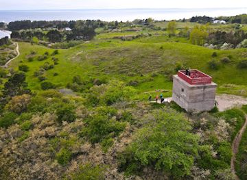
Evocative World War II coastal gun position on a Knebel hilltop, where stark concrete bunkers meet sweeping Kattegat views in Mols Bjerge National Park.
Kanonstilling is a World War II coastal gun position set on a low hill above Knebel in Mols Bjerge National Park. Built by German occupying forces to guard the Kattegat sea routes, the concrete bunkers, gun mounts and trenches now sit quietly among heather and grassland. Visitors can wander freely through the open site, explore the stark wartime structures and enjoy wide views over the sea and rolling Danish countryside in any season.
A brief summary to Kanonstilling
- Capellavej 98D, Knebel, 8420, DK
- Duration: 0.5 to 1.5 hours
- Free
-
Outdoor
- Mobile reception: 4 out of 5
- Monday 12 am-12 am
- Tuesday 12 am-12 am
- Wednesday 12 am-12 am
- Thursday 12 am-12 am
- Friday 12 am-12 am
- Saturday 12 am-12 am
- Sunday 12 am-12 am
Local tips
- Wear sturdy shoes; paths are natural, uneven and can be slippery after rain around the bunkers and on the grassy slopes.
- Bring water and snacks, as there are no facilities on the hilltop itself; the nearest options are in Knebel and nearby villages.
- Plan your visit for late afternoon or early evening if you enjoy photography, when low light emphasizes textures and long views.
- If visiting with children, agree clear boundaries around steep edges and bunker openings, as there are no safety barriers.
- Combine the stop with a longer hike in Mols Bjerge National Park to experience both the wartime site and the surrounding nature.
Other nearby places you may find interesting
Getting There
-
Car from Aarhus
From central Aarhus, travelling by car to Kanonstilling near Knebel typically takes 45–60 minutes, following regional roads across Djursland. The route is straightforward and free to use, with fuel costs the main expense. Expect very limited informal parking near the access point, usually on small gravel or grass verges; in busy summer periods you may need to park a little farther away and walk along country lanes. The final approach is on narrow rural roads that can be slippery in wet or icy conditions.
-
Regional bus and walk
Public buses connect Aarhus and other Djursland towns with Knebel and nearby stops, with journey times of about 1.5–2 hours including transfers. A single adult ticket typically costs in the range of 40–80 DKK depending on distance and zones. From the nearest bus stop, expect a 20–40 minute walk on minor roads and park trails over gently hilly terrain. Paths are unpaved and can be muddy after rain, so this option suits visitors comfortable with moderate walking and basic wayfinding.
-
Cycling from Knebel area
For those already staying in or around Knebel, cycling to Kanonstilling is a scenic option taking roughly 15–30 minutes from most local holiday houses and campsites. Use local roads and, where available, cycle-friendly lanes through the rolling countryside. There is no dedicated bike parking at the site, so you will need to leave your bicycle along a fence or hedge near the access point. The route involves some gentle climbs and open stretches exposed to wind, which can feel challenging on blustery days.
For the on-the-go comforts that matter to you
-
Trash Bins
-
Information Boards
Kanonstilling location weather suitability
-
Clear Skies
-
Mild Temperatures
-
Windy Conditions
-
Hot Weather
-
Cold Weather
-
Any Weather
Discover more about Kanonstilling
Wartime Strongpoint Above the Kattegat
Kanonstilling crowns a gentle rise above Knebel, where open fields and heathland fall away towards the sea. During World War II this hill was transformed by German occupying forces into a coastal artillery position, part of a chain of defences guarding vital shipping lanes through the Kattegat. Concrete gun emplacements, ammunition bunkers and communication positions were laid out to command long lines of fire over the water and surrounding landscape. Today the guns are gone, but the layout of the position is still clearly legible. Low, angular bunkers emerge from the grass, their entrances partly sheltered by earthen banks. Circular mounts hint at where heavy weapons once turned to track distant silhouettes on the horizon. Standing here, it is easy to imagine the tension of long watches, radar reports and coded orders carried on the wind.Concrete Relics in a Soft Landscape
Part of Kanonstilling’s power lies in the contrast between its hard geometry and the softness of Mols Bjerge National Park. The bunkers are stark and utilitarian, all thick walls, narrow doorways and slots for observation. Around them, the ground is carpeted with heather, wild grasses and low shrubs, buzzing with insects in summer and dusted with frost in winter. Rough paths weave between the structures, sometimes following old trenches cut into the hilltop. You can peer into shadowy interiors, trace rusted metal fittings and spot remnants of cable channels or drainage lines. Outside, the low profile of the works makes sense: from a distance they almost disappear into the slope, a deliberate attempt to blend defence with terrain.Panoramic Views Across Mols Bjerge
From the highest points of the site the views are as compelling as the history. The Kattegat stretches away in shifting blues and greys, dotted with passing ships that echo the strategic concerns of the 1940s. Closer at hand, the characteristic folds of Mols Bjerge roll across the peninsula, with fields, woodland patches and scattered farms creating a patchwork of colour. This openness makes Kanonstilling an appealing pause on a longer hike through the national park. In clear weather the horizon seems to expand in all directions, while on misty days the bunkers loom out of low cloud, emphasizing their brooding character. Sunsets can be particularly atmospheric, when the concrete softens to gold and long shadows pick out every contour of the works.An Open-Air Lesson in Coastal Defence
Although the site is modest in scale, it offers a concise introduction to coastal fortification. The arrangement of positions shows how overlapping arcs of fire were used to control both sea and land approaches. Simple information panels, mostly in Danish, help explain the role of the battery and its connection to wider defence networks along the Danish coast. Because the area is unfenced and free to access, exploration here feels informal and hands-on. Children often enjoy climbing gently over low walls and running between the structures, while history enthusiasts can spend longer examining details of construction and imagining the routines of the garrison who once served here. The absence of heavy modern intervention keeps the focus on the original wartime fabric.Quiet Atmosphere and Practical Considerations
Kanonstilling has no visitor centre, café or built facilities; its appeal lies in simplicity and a sense of discovery. The ground is uneven in places and paths are natural rather than surfaced, so sturdy footwear is helpful, especially after rain. The open setting also means that wind and weather are quickly felt, adding drama on blustery days but making warm layers and waterproofs a wise choice outside summer. Despite the lack of infrastructure, the site rarely feels remote. Mobile reception is generally reliable, and Knebel and other small settlements in the region provide options for food, water and restrooms before or after a visit. Combined with nearby viewpoints and coastal walks in Mols Bjerge National Park, Kanonstilling fits easily into a half-day exploration of this distinctive corner of Djursland.Explore the best of what Kanonstilling has to offer
Your all‑in‑one travel companion app
Explore expert travel guides, compare and book tours, experiences, hotels, and more—all from the palm of your hand. Download now for seamless trip planning wherever your wanderlust takes you.
More about Mols Bjerge National Park
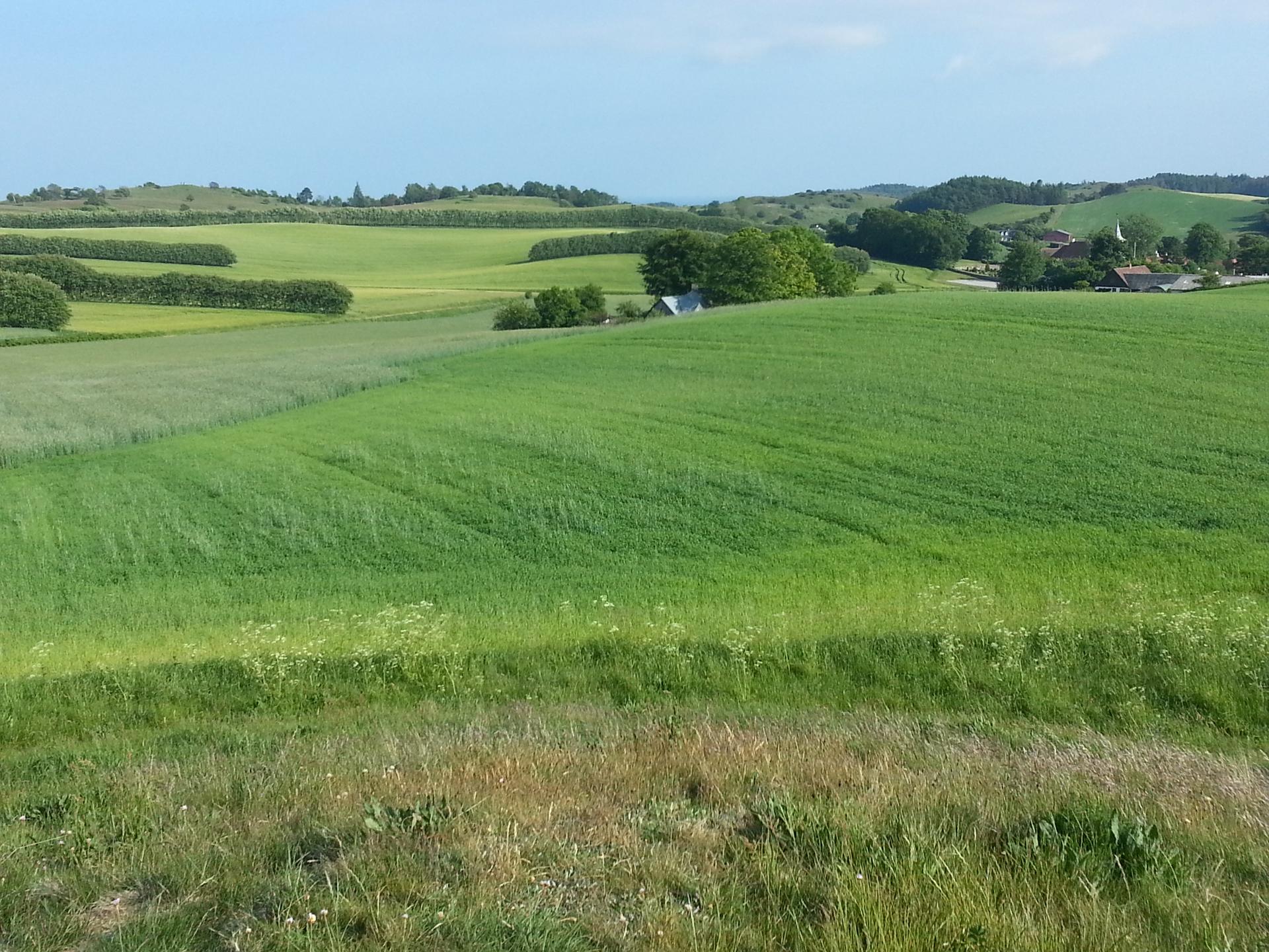
Discover the natural beauty and historical charm of Mols Bjerge National Park, where rolling hills, ancient woodlands, and serene lakes create a perfect outdoor escape.
Tell me more about Mols Bjerge National ParkRemote-feeling Danish peninsula where rugged cliffs, lighthouses and farmed hills meet star-filled night skies and some of Djursland’s most atmospheric coastal hikes.
A rugged World War II radar tower on Helgenæs, where concrete fortifications, sweeping sea views and the rolling hills of Mols Bjerge meet on a windswept headland.
Want to improve this location?
Activate this location now and let Evendo enhance its appearance, information, and visibility for millions of travellers.