Background

Tyskertårnet, Helgenæs

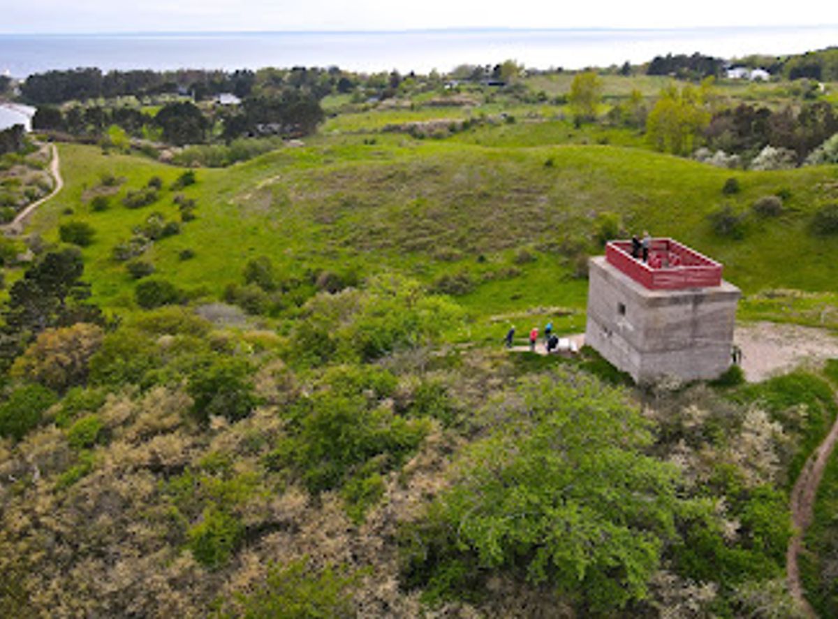
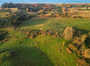
A rugged World War II radar tower on Helgenæs, where concrete fortifications, sweeping sea views and the rolling hills of Mols Bjerge meet on a windswept headland.

4.5

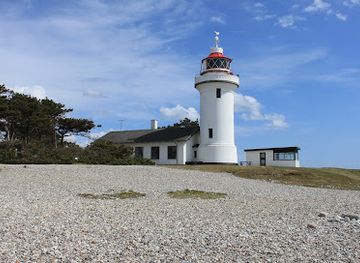
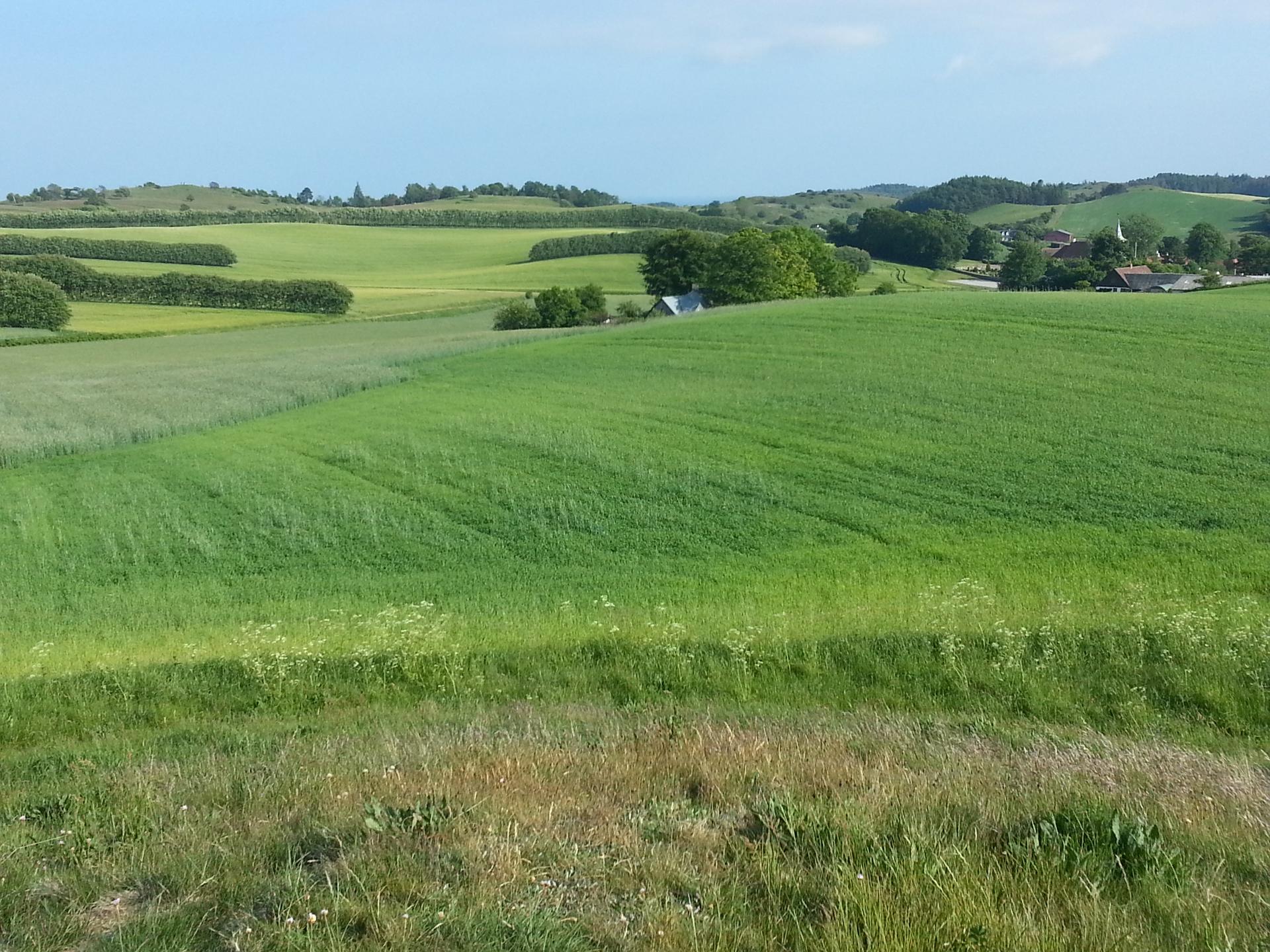
Tyskertårnet is a World War II German radar tower standing on the rugged Helgenæs peninsula near Sletterhage Lighthouse, in Mols Bjerge National Park. This concrete fortification crowns a low hill above the Kattegat, offering sweeping views towards Samsø, Tunø, Aarhus Bay and the Odder coast. Combined with the shoreline paths, bunkers and hilly grasslands, it is an evocative mix of military history, coastal scenery and short but sometimes steep walks.

A brief summary to Tyskertårnet

  • Tyskertårnet, Capellavej, Knebel, 8420, DK
  • Duration: 1 to 3 hours
  • Free
  • Environment icon Outdoor
  • Mobile reception: 4 out of 5
  • Monday 12 am-12 am
  • Tuesday 12 am-12 am
  • Wednesday 12 am-12 am
  • Thursday 12 am-12 am
  • Friday 12 am-12 am
  • Saturday 12 am-12 am
  • Sunday 12 am-12 am

Local tips

  • Wear sturdy shoes: the climb from the beach up to Tyskertårnet can be steep, uneven and slippery in wet or windy weather.
  • Aim for clear weather if you can; on good days you may see as far as Samsø, Tunø, Aarhus Bay and the Odder coast from the hilltop.
  • Combine the tower with nearby Sletterhage Lighthouse for a varied circular walk that mixes shoreline, hills and wartime remains.
  • Bring windproof layers even in summer, as the exposed headland and hill can feel significantly cooler than sheltered inland spots.
  • Pack water and snacks; there are no services at the tower itself, and you will likely want to linger and enjoy the views.
widget icon

Getting There

  • Car from Ebeltoft

    From Ebeltoft town, driving to Tyskertårnet on Helgenæs typically takes about 30–40 minutes, following local roads across Mols and out along the peninsula. The route is on standard paved roads suitable for all vehicles, with some narrow stretches near the end. Parking is usually done near Sletterhage Lighthouse or along Capellavej, both free of charge; from there you continue on foot via waymarked coastal paths to the tower. There are no tolls and no entrance fee at the site.

  • Bus plus walk from Aarhus region

    From Aarhus, you can use regional buses towards Ebeltoft or Knebel and connect to local services serving Helgenæs; total travel time typically ranges from 1.5 to 2.5 hours depending on connections and season. A single adult ticket on regional buses is usually around 40–80 DKK, with discounts using regional travel cards. Services can be infrequent, especially on weekends and holidays, so checking timetables in advance is essential. Expect a final walk of 2–4 km on minor roads and coastal paths to reach the tower from the nearest bus stop.

  • Cycling from Mols Bjerge area

    Cyclists based in the Mols Bjerge area often ride to Helgenæs and Tyskertårnet as part of a scenic loop. From central Knebel to the tower, allow around 45–70 minutes each way, including some short, steep climbs and exposed sections where wind can be strong. The route follows a mix of minor paved roads and, near the end, unsurfaced tracks where wider tyres are helpful. There is no fee to visit, but carry water and lights if returning late, as roadside lighting is limited outside villages.

Tyskertårnet location weather suitability

  • Weather icon Clear Skies
  • Weather icon Windy Conditions
  • Weather icon Mild Temperatures
  • Weather icon Cold Weather
  • Weather icon Hot Weather
  • Weather icon Any Weather

Unlock the Best of Tyskertårnet

Buy tickets

    No tickets available

Book tours with entry

    No tours available

Book tours without entry

    No tours available

Discover more about Tyskertårnet

A wartime radar tower on a Danish headland

Tyskertårnet is a squat, bunker-like concrete tower on the Helgenæs peninsula, once part of a German radar installation during World War II. Built to control and monitor ship traffic through the busy waters of Aarhus Bay and the Kattegat, it formed a link in a chain of coastal defenses that stretched along Denmark’s shoreline. The thick walls, narrow openings and utilitarian form are functional rather than decorative, clearly shaped by military priorities. The structure stands slightly inland from the coast, raised on a hill that provides a natural vantage point. Around it you can still sense traces of the broader fortification system: embankments, scattered concrete remains and the outlines of former gun positions. Together they tell a compact but tangible story of occupied Denmark and the strategic importance of Helgenæs in controlling maritime routes.

Views across sea, islands and rolling hills

What once offered tactical overview today gives wide-open panoramas. From the tower and surrounding hilltop, your gaze sweeps across the Kattegat towards Samsø and Tunø on clear days, and back inland to the undulating landscape of Mols Bjerge. The combination of sea, sky and low, rounded hills creates a sense of space that feels much larger than the tower itself. On blustery days the wind can be brisk, bringing the smell of salt and seaweed up from the stony shoreline below. In softer weather, the sunlight shifts over the water and the mosaic of fields and heathland around Helgenæs. The open horizon and constant movement of ships and ferries give the site a dynamic backdrop, a peaceful contrast to its martial origin.

Paths, gradients and the character of the walk

Tyskertårnet is often combined with a walk from nearby Sletterhage Lighthouse, following a path along the beach before climbing into the hilly terrain. The route is relatively short but can feel surprisingly demanding in places, with some steep, sandy or stony stretches as you ascend from the shore up to the tower. Good footwear is useful, especially in wet or windy conditions. Once on the higher ground, the walking becomes easier, following grassy tracks and informal desire paths across open slopes. The landscape has a slightly wild, windswept feel, with low vegetation, patches of heath and scattered shrubs rather than dense woodland. It gives the experience more of a coastal hike than a casual promenade, while still remaining accessible to most reasonably fit visitors.

Traces of conflict in a peaceful national park

Although the military function has long since disappeared, the tower remains a stark reminder of the 1940s. Its presence within today’s protected landscape underlines how thoroughly the area has been reinterpreted: from a strategic outpost to a place for reflection, picnics and photography. The simple, robust forms of concrete and earthwork contrast with the soft curves of the hills and the constant play of light on the sea. Interpretive information about the wartime role of Helgenæs can be found through regional nature and heritage guides, which place Tyskertårnet within wider defensive lines, nearby bunkers and other remains from the same period. Many visitors choose to link their stop here with other viewpoints in Mols Bjerge, turning it into part of a broader exploration of both natural and cultural landscapes.

Planning your visit to the tower

The site is unfenced and outdoors, with no formal ticketing, and is typically visited during the day, when the views are at their best. The exposed position means weather matters: clear or partly sunny days showcase the long-distance vistas, while mist and low clouds can lend the place a more introspective, atmospheric mood. Windproof clothing is advisable most of the year, and in summer the open slopes can feel quite warm in full sun. Facilities directly at the tower are minimal, but basic amenities are available at Sletterhage Lighthouse and other points on Helgenæs, making it easy to combine the tower with rest stops, picnics or a longer coastal circuit. Whether you stay briefly for the view or linger to trace the outlines of wartime defenses, Tyskertårnet offers a compact, evocative encounter with both history and landscape.

Busiest months of the year

Busiest hours of the day

Popular Experiences near Tyskertårnet

Popular Hotels near Tyskertårnet

Select Currency