

Tikal National Park Travel Guide - Free Web & App
Your ultimate guide to Tikal National Park. Discover top landmarks, proposed trips, and local tips. Free on the web or via the Evendo companion app.


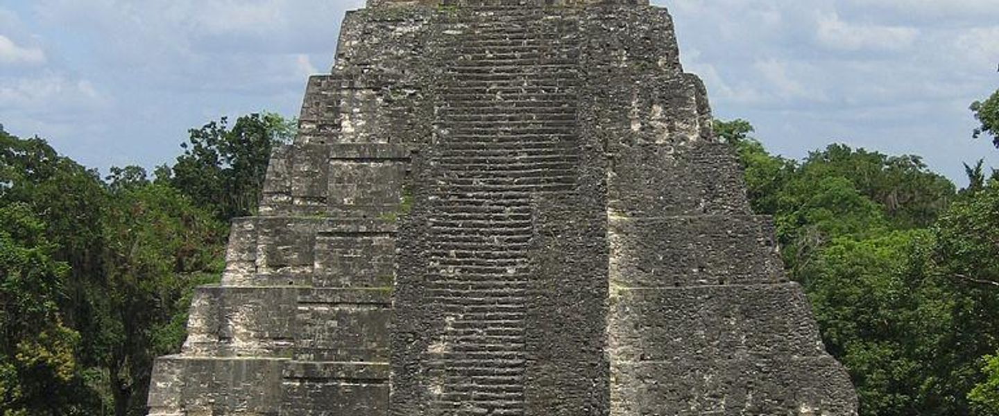


Tikal National Park, Guatemala, brings Maya temples, rainforest wildlife, ancient plazas and sunrise exploration near Flores in the Petén region.
Rainforest and Ruins
Tikal National Park occupies part of Guatemala’s northern Petén region, where monumental Maya architecture rises above broadleaf rainforest. The archaeological site is the centrepiece of a protected landscape extending across the Maya Biosphere Reserve, a vast conservation area shared by forests, wetlands and other ancient Maya sites. Tikal’s great plazas, pyramids, palaces, temples and causeways are dispersed through dense vegetation rather than arranged as a compact modern town, so visiting involves substantial walking on uneven forest paths.Read more about Tikal National Park
The Ancient City
Wildlife and Visitor Bases
When is the best time to visit Tikal National Park?
Best: June–August · 31°C| Month | High (°C) | Rainfall (mm) |
|---|---|---|
| January | 30 | 50 |
| February | 31 | 45 |
| March | 31 | 40 |
| April | 31 | 35 |
| May | 32 | 25 |
| June (best) | 31 | 20 |
| July (best) | 31 | 20 |
| August (best) | 31 | 25 |
| September | 31 | 30 |
| October | 31 | 35 |
| November | 30 | 40 |
| December | 30 | 45 |
Getting to and around Tikal National Park
How to get there
Transportation
Best attractions in Tikal National Park
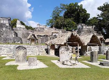
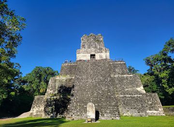
The central archaeological zone contains Tikal’s defining attractions: the Great Plaza, framed by Temple I and Temple II, the North Acropolis with its layered funerary and ceremonial architecture, and the Central Acropolis, a complex of palaces and courtyards. The Mundo Perdido, or Lost World, presents another important architectural group, while the Seven Temples Plaza reveals the city’s impressive ceremonial planning. Temple IV is the tallest of Tikal’s major pyramids and is associated with one of the best-known elevated views across the forest canopy, subject to current access rules. Causeways lead between dispersed groups where temples, reservoirs, stelae and vegetation convey the scale of the ancient city. Beyond the ruins, the park’s rainforest offers opportunities to notice howler monkeys, coatis, birds and other wildlife, although sightings are never guaranteed. The museum area near the entrance adds archaeological context before or after the longer walks.
-
Historical landmark
North Acropolis, Tikal
Explore the North Acropolis in Tikal, a royal necropolis showcasing over 1300 years of Maya history, architecture, and funerary traditions.
-
Museum
Templo II,Tikal,Guatemala
Explore the majestic Templo II in Tikal, Guatemala, and uncover the rich history of the ancient Maya civilization amidst stunning jungle landscapes.
-
Tourist attraction
Palacio de las Acanaladuras
Explore the Palacio de las Acanaladuras in Tikal, an ancient Mayan palace showcasing remarkable architecture and offering a glimpse into royal life.
-
National park
Biotopo Protegido San Miguel La Palotada El Zotz
Discover El Zotz: Explore Mayan history and diverse wildlife in Guatemala's hidden gem, a natural paradise near Tikal.


Best landmarks in Tikal National Park
Tikal’s most important landmarks are monumental expressions of Maya political and religious life set within a living tropical forest. Temple I, also known as the Temple of the Great Jaguar, dominates the eastern side of the Great Plaza opposite Temple II, the Temple of the Masks; together they create the site’s most recognisable architectural composition. The North Acropolis preserves generations of temples and elite burials, while the Central Acropolis presents an extensive arrangement of palaces around elevated courtyards. Temple IV is distinguished by its height and forest outlook, and the Great Plaza’s carved stelae and altars connect architecture with dynastic commemoration. The stone monuments are inseparable from the rainforest setting, where reservoirs, causeways and concealed mounds reveal that Tikal was an extensive urban landscape rather than a collection of isolated pyramids.
-
National park
TIKAL National Park
Discover the breathtaking TIKAL National Park, a UNESCO World Heritage site filled with ancient Mayan ruins and lush tropical jungles, perfect for adventure and exploration.
-
Archaeological site
The Lost World
Explore the Lost World of Tikal: An archaeological marvel nestled in lush jungles, rich in history and biodiversity.


Explore Tikal National Park on the map
Plan your trip on one map. See where the top attractions, landmarks, restaurants and hotels are, and book hotels and experiences in a few clicks.
Best hotels in Tikal National Park
Best restaurants in Tikal National Park
Dining within Tikal National Park is limited and visitors should not expect a town-like restaurant scene among the ruins. The main choices are generally associated with the park entrance and with accommodation or visitor facilities in the surrounding area, so many travellers carry water and simple provisions for the hours spent walking. Flores and Santa Elena offer the widest range of Guatemalan and international food, from casual cafés to restaurants serving dishes such as pepián, tamales and tortillas, while El Remate has a smaller selection linked to lakeside guesthouses and tourism businesses. Local produce from the Petén may appear in regional cooking, but menus and opening arrangements vary. Travellers staying outside the main towns should organise meals in advance, particularly when transport to the park is arranged for an early start.
-
Restaurant
Tikal Park’s Restaurant
Experience local flavors amidst ancient wonders at Tikal Park's Restaurant – your culinary retreat in Guatemala's iconic national park.
-
 Hotel
Hotel Tikal Inn, Tikal
Discover serenity and adventure at Hotel Tikal Inn, your gateway to exploring the wonders of Tikal National Park.
-
Restaurant
Comedor Imperio Maya
Experience authentic Guatemalan cuisine surrounded by the awe-inspiring ruins of Tikal at Comedor Imperio Maya.


Best bars in Tikal National Park
Tikal itself has no meaningful nightlife infrastructure, and evenings in the park are governed by the protected landscape rather than by bars or entertainment venues. The most characteristic after-dark experience is a quiet return to accommodation near the site, El Remate or the Flores area, where visitors may find a drink or relaxed conversation rather than a late-night scene. Flores, particularly around the island and its waterfront streets, has the Petén’s broadest choice of informal bars and restaurants, while Santa Elena provides more practical local services. Evening offerings can be seasonal and modest outside Flores, so the destination suits early starts, nocturnal wildlife sounds and dark forest surroundings more than clubbing. Any night-time walk or wildlife activity should be arranged through an appropriate local provider rather than undertaken independently in the park.
-
Restaurant
Tikal Park’s Restaurant
Experience the essence of Guatemalan cuisine amidst the ancient wonders of Tikal National Park, with delightful dishes and stunning jungle views.
-
Hotel
Hotel Tikal Inn, Tikal
Discover the perfect blend of adventure and relaxation at Hotel Tikal Inn, your gateway to the majestic Tikal National Park.

Best nightclubs in Tikal National Park
Tikal itself has no meaningful nightlife infrastructure, and evenings in the park are governed by the protected landscape rather than by bars or entertainment venues. The most characteristic after-dark experience is a quiet return to accommodation near the site, El Remate or the Flores area, where visitors may find a drink or relaxed conversation rather than a late-night scene. Flores, particularly around the island and its waterfront streets, has the Petén’s broadest choice of informal bars and restaurants, while Santa Elena provides more practical local services. Evening offerings can be seasonal and modest outside Flores, so the destination suits early starts, nocturnal wildlife sounds and dark forest surroundings more than clubbing. Any night-time walk or wildlife activity should be arranged through an appropriate local provider rather than undertaken independently in the park.
-
Restaurant
Tikal Park’s Restaurant
Experience the culinary delights of Tikal Park’s Restaurant, a perfect blend of local flavors and stunning natural beauty in Guatemala's ancient rainforest.

Get your free copy of our complete guide to Tikal National Park, delivered straight to you.
Everything on this page, from attractions and restaurants to essentials and local phrases, in one PDF you can read offline, print or share.
Already have an account? Sign in
Your Tikal National Park guide is ready.
We'll send it to · Not you? Sign out

Getting your guide ready…
We are putting together a fresh copy of the Tikal National Park guide. This can take up to a minute.
This can take a few moments. If your browser asks, choose Allow so the download can start. You'll find the guide in your Downloads folder.
Nothing happened? Download it again
Sorry, the guide is taking longer than usual. Please try again in a minute, or get it by email instead.
Tikal National Park essentials
Currency and Payment
Safety
Emergency Situations
Do's and Don'ts
Local Tips
From Eve
Local phrases worth knowing
You don't need to get them perfect. A few words go a long way, and locals appreciate the effort.
Basics
| English | Local | Say it |
|---|---|---|
| Hello | Hola | [oh-lah] |
| Goodbye | Adiós | [ah-dee-ohs] |
| Yes | Sí | [see] |
| No | No | [noh] |
| Please/You're welcome | Por favor/De nada | [por fah-vohr/deh nah-dah] |
| Thank you | Gracias | [grah-see-ahs] |
| Excuse me/Sorry | Perdón/Lo siento | [pehr-dohn/loh see-ehn-toh] |
| How are you? | ¿Cómo estás? | [koh-moh ehs-tahs] |
| Fine. And you? | Bien. ¿Y tú? | [byehn. ee too] |
| Do you speak English? | ¿Hablas inglés? | [ah-blahs een-glehs] |
| I don't understand | No entiendo | [noh ehn-tee-ehn-doh] |
Eating & Drinking
| English | Local | Say it |
|---|---|---|
| I'd like to see the menu, please | Me gustaría ver el menú, por favor | [meh goos-tah-ree-ah behr ehl meh-noo, por fah-vor] |
| I don't eat meat | No como carne | [noh koh-moh kahr-neh] |
| Cheers! | ¡Salud! | [sah-lood] |
| I would like to pay, please | Me gustaría pagar, por favor | [meh goos-tah-ree-ah pah-gar, por fah-vor] |
Emergencies
| English | Local | Say it |
|---|---|---|
| Help! | ¡Ayuda! | [ah-yoo-dah] |
| Go away! | ¡Vete! | [veh-teh] |
| Call the Police! | ¡Llame a la policía! | [yah-meh ah lah poh-lee-see-ah] |
| Call a doctor! | ¡Llame a un médico! | [yah-meh ah oon meh-dee-koh] |
| I'm lost | Estoy perdido | [ehs-toy pehr-dee-doh] |
| I'm ill | Estoy enfermo | [ehs-toy ehn-fehr-moh] |
Shopping
| English | Local | Say it |
|---|---|---|
| I'd like to buy... | Me gustaría comprar... | [meh goos-tah-ree-ah kohm-prahr] |
| I'm just looking | Sólo estoy mirando | [soh-loh ehs-toy mee-rahn-doh] |
| How much is it? | ¿Cuánto cuesta? | [kwan-toh kwehs-tah] |
| That's too expensive | Esto es muy caro | [ehs-toh ehs mwee kah-roh] |
| Can you lower the price? | ¿Puede bajar el precio? | [pweh-deh bah-har ehl preh-syoh] |
Time & Numbers
| English | Local | Say it |
|---|---|---|
| What time is it? | ¿Qué hora es? | [keh oh-rah ehs] |
| It's one o'clock | Es la una en punto | [ehs lah oo-nah ehn poon-toh] |
| Half past (10) | Las diez y media | [lahs dyehs ee meh-dee-ah] |
| Morning | Mañana | [mah-nyah-nah] |
| Afternoon | Tarde | [tahr-deh] |
| Evening | Noche | [noh-cheh] |
| Yesterday | Ayer | [ah-yehr] |
| Today | Hoy | [oy] |
| Tomorrow | Mañana | [mah-nyah-nah] |
| 1 | Uno | [oo-noh] |
| 2 | Dos | [dohs] |
| 3 | Tres | [trehs] |
| 4 | Cuatro | [kwah-troh] |
| 5 | Cinco | [seen-koh] |
| 6 | Seis | [sehs] |
| 7 | Siete | [syeh-teh] |
| 8 | Ocho | [oh-choh] |
| 9 | Nueve | [nweh-veh] |
| 10 | Diez | [dyehs] |
Transport & Directions
| English | Local | Say it |
|---|---|---|
| Where's a/the...? | ¿Dónde está el/la...? | [dohn-deh ehs-tah ehl/lah] |
| What's the address? | ¿Cuál es la dirección? | [kwahl ehs lah dee-rehk-see-ohn] |
| Can you show me (on the map)? | ¿Puede enseñarme (en el mapa)? | [pweh-deh ehn-seh-nyar-meh (ehn ehl mah-pah)] |
| When's the next (bus)? | ¿Cuándo es el próximo (autobús)? | [kwan-doh ehs ehl prohk-see-moh (ow-toh-booce)] |
| A ticket (to ....) | Un boleto (a ....) | [oon boh-leh-toh (ah)] |
History of Tikal National Park
A Limestone Landscape in the Maya Lowlands
Tikal stands in the central Petén, a lowland region formed largely from limestone and shaped by tropical forest, seasonal watercourses and karst terrain. This environment provided building stone, timber, plants and game, but it did not offer abundant surface rivers immediately beside the city. Maya inhabitants therefore relied on reservoirs and carefully managed water systems, an important factor in the development of a large urban centre in a seasonally variable landscape. The forest visible today is not simply a timeless wilderness: it has been shaped by centuries of human occupation, abandonment, regeneration and modern conservation.
Early Settlement and Urban Growth
Human occupation at Tikal began centuries before the city reached its Classic-period prominence. By the first millennium BC, communities were establishing ceremonial and residential features in the area, and later rulers expanded the settlement with monumental platforms, plazas and reservoirs. Tikal’s location connected it to wider networks across the Maya lowlands, supporting political influence, trade and cultural exchange. The surviving architecture represents only part of a much larger city that included densely occupied areas, causeways, water infrastructure and buildings now concealed beneath forest and archaeological mounds.
Tikal in the Classic Maya World
During the Classic period, especially from the third to the ninth centuries AD, Tikal became a major Maya kingdom whose rulers commissioned temples, funerary monuments and palace complexes. Its inscriptions record dynastic history and relationships with other powerful centres, including periods of rivalry and alliance. The city’s architecture expressed authority through height, scale and carefully arranged ceremonial spaces. Temple I, associated with the ruler Jasaw Chan K’awiil I, and the North Acropolis illustrate the continuing importance of royal burial and ritual, while the Great Plaza formed one of the city’s principal civic and ceremonial settings.
Abandonment, Forest and Rediscovery
Tikal’s monumental construction and political power declined during the ninth century, as did those of many other Classic Maya cities, although the reasons were complex and may have included social, political and environmental pressures. The site was not erased from local knowledge, but its major structures became enveloped by forest. European accounts in the nineteenth century helped bring Tikal to wider outside attention, and systematic archaeological work expanded during the twentieth century. Excavation, mapping and conservation gradually revealed the scale of the urban centre while also demonstrating how much remains beneath vegetation and earth.
Archaeology and Conservation
Modern Tikal is protected as a national park and is part of the wider conservation framework of the Maya Biosphere Reserve. UNESCO designated Tikal a World Heritage Site in 1979 for both its cultural and natural significance, making it one of the earliest properties recognised for this combined importance. Archaeological research and restoration have transformed understanding of Maya civilisation, while park management aims to balance public access with the protection of fragile stonework, forest habitats and wildlife. Tourism is consequently shaped by conservation rules, controlled access and the need to protect a large landscape rather than a single isolated monument.
Tikal National Park in Photos
Browse through our photo collection highlighting the charm and character of the destination.
Cities in Tikal National Park
The towns and cities of Tikal National Park, and the easiest places to base yourself.

Swipe for more cities
Neighbouring destination travel guides
The closest destinations to Tikal National Park, if you have time for more than one.
-

-

-

-

-


Swipe for more destinations
Explore more

Explore more of Northern Lowlands
Discover the Northern Lowlands of Guatemala: a blend of ancient Maya ruins, lush rainforests, and vibrant local culture, offering an unforgettable adventure in Central America.
Explore Northern Lowlands
Explore more of Guatemala
Discover Guatemala: A land of ancient Mayan wonders, breathtaking natural beauty, and vibrant cultural experiences. Perfect for history buffs, nature lovers, and adventure seekers.
Explore Guatemala