

Gosaikunda Travel Guide - Free Web & App
Your ultimate guide to Gosaikunda. Discover top landmarks, proposed trips, and local tips. Free on the web or via the Evendo companion app.


Gosaikunda, Nepal, is a sacred alpine lake in Langtang National Park, celebrated for Himalayan trekking, pilgrimage and mountain landscapes.
Lake and Mountain Setting
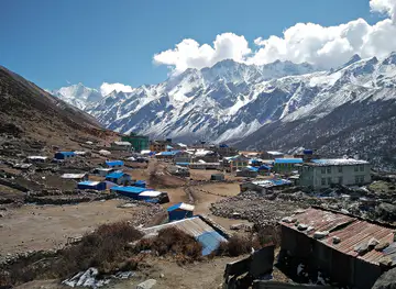
Gosaikunda is a high-altitude lake in Nepal’s Langtang National Park, in Rasuwa District north of Kathmandu. Reached by trekking through forested hills, rhododendron country and increasingly open alpine terrain, the lake lies at about 4,380 metres beneath a rugged Himalayan skyline. It forms part of a wider group of glacial lakes that includes Saraswati Kunda and Bhairab Kunda, while the challenging Laurebina Pass provides one of the trek’s defining high points. The landscape changes quickly with altitude: terraced settlements and woodland give way to juniper, exposed ridges, rocky slopes and sparse vegetation around the lake basin.Read more about Gosaikunda
Pilgrimage and Local Character
Trekking in Langtang National Park
When is the best time to visit Gosaikunda?
Best: April–May, September · 8–14°C| Month | High (°C) | Rainfall (mm) |
|---|---|---|
| January | -1 | 20 |
| February | 1 | 20 |
| March | 5 | 40 |
| April (best) | 8 | 60 |
| May (best) | 13 | 100 |
| June | 16 | 150 |
| July | 18 | 200 |
| August | 17 | 160 |
| September (best) | 14 | 120 |
| October | 10 | 80 |
| November | 6 | 40 |
| December | 2 | 20 |
Getting to and around Gosaikunda
How to get there
Transportation
Best attractions in Gosaikunda
The central attraction is Gosaikunda itself, a dark, high Himalayan lake surrounded by rocky slopes and often snow-dusted mountains. Nearby Saraswati Kunda and Bhairab Kunda form part of the same sacred alpine landscape, while the ascent towards Laurebina Pass brings broad views across Langtang and the surrounding ranges when the weather is clear. Lower sections of the route pass through rhododendron and mixed mountain forest, with villages such as Dhunche, Thulo Syabru and Lauribina offering insight into local life and trekking culture. The wider Langtang National Park adds rich habitat diversity, from woodland and high pastures to exposed alpine terrain, although wildlife sightings are unpredictable. Gosaikunda is also an important pilgrimage destination, particularly during Janai Purnima, when Hindu devotees gather at the lake for ritual bathing and worship. The appeal lies in the changing landscape along the trek as much as in the lakeside destination.
-
Religious destination
ᤛᤣᤘᤠᤖᤥ Gosaikunda
Explore Gosaikunda, a sacred lake in Nepal's stunning Himalayas, where spirituality meets breathtaking natural beauty.
-
Tourist attraction
Gosaikunda View Point
Discover Gosaikunda View Point, a stunning Himalayan destination offering breathtaking views of lakes and mountains, perfect for adventure and tranquility.
-
Hiking area
Gosainkunda Trek
Explore the majestic Gosainkunda Trek, a sacred Himalayan adventure featuring stunning lakes, breathtaking views, and rich local culture.


Best landmarks in Gosaikunda
Gosaikunda is the defining natural and religious landmark, its high lake basin revered in Hindu tradition as a place connected with Shiva and visited for ritual bathing. Saraswati Kunda and Bhairab Kunda are associated alpine lakes nearby, while the ridge and pass at Laurebina provide a memorable geographical threshold between lower forested hills and exposed high country. The route’s settlements are landmarks of a different kind: Dhunche and Thulo Syabru are established gateways, while Lauribina marks the increasingly austere environment approaching the lake. Within Langtang National Park, forests, pastures, rocky ridges and glacially influenced lake basins together form a protected Himalayan landscape. The significance of these features is both physical and cultural, since the mountain trails connect local communities, pilgrimage traditions and conservation areas rather than presenting isolated monuments.
-
Lake
Gosainkunda
Discover the serene beauty and spiritual significance of Gosainkunda, a breathtaking lake nestled in the Himalayas of Nepal.
-
Religious destination
ᤛᤣᤘᤠᤖᤥ Gosaikunda
Explore the spiritual and natural wonders of Gosaikunda, a sacred lake in the Himalayas offering breathtaking views and profound experiences.
-
Tourist attraction
Gosaikunda View Point
Discover the breathtaking vistas of Gosaikunda View Point, a serene Himalayan retreat nestled amidst stunning mountain landscapes.
-
Camping cabin
Gosaikunda Lakeside View
Experience the stunning beauty of Gosaikunda Lakeside View, a tranquil destination in Nepal that offers breathtaking landscapes and serene camping adventures.


Explore Gosaikunda on the map
Plan your trip on one map. See where the top attractions, landmarks, restaurants and hotels are, and book hotels and experiences in a few clicks.
Best hotels in Gosaikunda
Best shops in Gosaikunda
Shopping around Gosaikunda is limited to practical supplies and small locally produced or trek-related goods rather than an extensive retail scene. Dhunche, Syabrubesi and other lower gateway settlements are the most useful places for snacks, basic equipment, clothing, toiletries and trekking necessities before the ascent. Teahouses along the route may sell a narrow selection of food, drinks and essentials, but visitors should not depend on them for specialist equipment or a wide choice of souvenirs. In the wider Langtang area, travellers may encounter handmade woollens, woven items and locally produced goods associated with Himalayan communities, although availability varies and purchases should be made respectfully. Carrying reusable containers and avoiding unnecessary plastic packaging is particularly appropriate in a remote, environmentally sensitive mountain landscape.
-
Hiking area
Gosainkunda Trek
Explore the sacred beauty of the Gosainkunda Trek, a stunning hiking area in Nepal known for its breathtaking lakes and spiritual significance.

Get your free copy of our complete guide to Gosaikunda, delivered straight to you.
Everything on this page, from attractions and restaurants to essentials and local phrases, in one PDF you can read offline, print or share.
Already have an account? Sign in
Your Gosaikunda guide is ready.
We'll send it to · Not you? Sign out

Getting your guide ready…
We are putting together a fresh copy of the Gosaikunda guide. This can take up to a minute.
This can take a few moments. If your browser asks, choose Allow so the download can start. You'll find the guide in your Downloads folder.
Nothing happened? Download it again
Sorry, the guide is taking longer than usual. Please try again in a minute, or get it by email instead.
Gosaikunda essentials
Currency and Payment
Safety
Emergency Situations
Do's and Don'ts
Local Tips
From Eve
Local phrases worth knowing
You don't need to get them perfect. A few words go a long way, and locals appreciate the effort.
Basics
| English | Local | Say it |
|---|---|---|
| Hello | नमस्ते | [Namaste] |
| Goodbye | फेरी भेटौं | [Feri bhetaun] |
| Yes | हो | [Ho] |
| No | होईन | [Hoin] |
| Please/You're welcome | कृपया | [Kripaya] |
| Thank you | धन्यवाद | [Dhanyabad] |
| Excuse me/Sorry | माफ गर्नुहोस् | [Maaf garnuhos] |
| How are you? | तपाईंलाई कस्तो छ? | [Tapailai kasto chha?] |
| Fine. And you? | राम्रो छ। तिमी कस्तो छौ? | [Ramro chha. Timi kasto chhau?] |
| Do you speak English? | तिमी अंग्रेजी बोल्छौ? | [Timi angreji bolchhau?] |
| I don't understand | मैले सम्झिन | [Maile samjhin] |
Eating & Drinking
| English | Local | Say it |
|---|---|---|
| I'd like to see the menu, please | कृपया मेनु हेर्न चाहन्छु | [Kripaya menu hern chahanchhu] |
| I don't eat meat | म मासु काम्छैन | [Ma masu kamchain] |
| Cheers! | चियर्स! | [Cheers!] |
| I would like to pay, please | कृपया भुक्तानी गर्न चाहन्छु | [Kripaya bhuktani garan chahanchhu] |
Emergencies
| English | Local | Say it |
|---|---|---|
| Help! | मदत! | [Madat!] |
| Go away! | दूर हुनुहोस्! | [Dur hunuhos!] |
| Call the Police! | पोलिसलाई बुलाउनुहोस्! | [Polis lai bulaunuhos!] |
| Call a doctor! | डाक्टरलाई बुलाउनुहोस्! | [Doctor lai bulaunuhos!] |
| I'm lost | म हराएको छु | [Ma haraeko chu] |
| I'm ill | म अस्वस्थ छु | [Ma asvasth chu] |
Shopping
| English | Local | Say it |
|---|---|---|
| I'd like to buy... | म किन्न चाहन्छु... | [Ma kinn chahanchhu...] |
| I'm just looking | म सिर्जना गरिरहेको छु | [Ma sirjana gari raheko chu] |
| How much is it? | यो कति हो? | [Yo kati ho?] |
| That's too expensive | यो धेरै महँगो छ | [Yo dherai mahango chha] |
| Can you lower the price? | के तपाईं मूल्य माथि गर्न सक्नुहुन्छ? | [Ke tapai mulya mathi garn saknuhunchha?] |
Time & Numbers
| English | Local | Say it |
|---|---|---|
| What time is it? | कति बजेको छ? | [Kati bajeko chha?] |
| It's one o'clock | एक बजे छ | [Ek baje chha] |
| Half past (10) | दसबजे अर्धा | [Dasbaje ardha] |
| Morning | बिहान | [Bihaan] |
| Afternoon | दिउँसो | [Diunso] |
| Evening | सांझ | [Saanjh] |
| Yesterday | हिजो | [Hijo] |
| Today | आज | [Aaj] |
| Tomorrow | भोलि | [Bholi] |
| 1 | एक | [Ek] |
| 2 | दुई | [Dui] |
| 3 | तीन | [Tin] |
| 4 | चार | [Char] |
| 5 | पाँच | [Paanch] |
| 6 | छ | [Chh] |
| 7 | सात | [Saath] |
| 8 | आठ | [Aath] |
| 9 | नौ | [Nau] |
| 10 | दस | [Das] |
Transport & Directions
| English | Local | Say it |
|---|---|---|
| Where's a/the...? | कहाँ छ...? | [Kaha chha...?] |
| What's the address? | ठेगाना के हो? | [Thegana ke ho?] |
| Can you show me (on the map)? | के तपाईं मलाई देखाउन सक्नुहुन्छ (नक्सा मा)? | [Ke tapai malai dekhaun saknuhunchha (Naksha ma)?] |
| When's the next (bus)? | अर्को (बस) कहिले जान्छ? | [Arko (Bas) kahile janchh?] |
| A ticket (to ....) | टिकट (मा ....) | [Ticket (ma ....)] |
History of Gosaikunda
A Himalayan Lake Basin
Gosaikunda occupies a high mountain basin shaped by glacial processes and seasonal snow and ice. It is part of a cluster of alpine lakes in the Langtang landscape, including Saraswati Kunda and Bhairab Kunda. The surrounding terrain reflects the sharp transition between the forested middle hills and the exposed high-altitude zone, where vegetation is sparse and weather has a strong influence on access. This geological and ecological setting explains why the lake has long been experienced as a remote, elevated place rather than as a settled landscape.
Sacred Traditions of Shiva
Hindu tradition identifies Gosaikunda with Shiva, also known as Gosain or Gosaikund in regional usage. According to religious belief, Shiva struck the ground with his trident to create the lake after consuming poison, making its waters sacred. The story has given the site enduring importance in pilgrimage culture, particularly during Janai Purnima, when devotees travel to bathe and perform worship. The religious significance of the lake is inseparable from the physical difficulty of reaching it, with the mountain journey forming part of the devotional experience.
Buddhist and Himalayan Communities
The route to Gosaikunda passes through Himalayan communities whose cultural life reflects the interaction of Hindu pilgrimage, Buddhist practice and long-established mountain livelihoods. Villages such as Dhunche and Thulo Syabru have developed as gateways and resting points for travellers moving through the Langtang region. Local life has traditionally depended on farming, livestock, trade and the movement of people along mountain paths. The trail therefore connects a sacred landscape with living settlements rather than leading through an uninhabited wilderness.
National Park and Trekking Era
Gosaikunda lies within Langtang National Park, established in 1976 as Nepal’s first Himalayan national park. Protection brought greater attention to the region’s forests, alpine habitats and wildlife while formalising conservation alongside local use of the landscape. Trekking gradually became an important source of income for communities on the route, supporting teahouses, guides, porters and small-scale services. The 2015 earthquake caused severe disruption across parts of Langtang and Rasuwa, and rebuilding has continued to shape facilities and trekking arrangements in the wider region.
Gosaikunda in Photos
Browse through our photo collection highlighting the charm and character of the destination.
Neighbouring destination travel guides
The closest destinations to Gosaikunda, if you have time for more than one.
-

-
-

-

-


Swipe for more destinations
Explore more
Explore more of Bagmati Zone
Explore Bagmati Zone in Nepal for Kathmandu Valley heritage, Newar culture, forested hills, rural towns and access to Langtang’s mountain landscapes.
Explore Bagmati Zone
Explore more of Nepal
Discover Nepal: A land of towering peaks, spiritual harmony, and vibrant culture, offering endless adventures and serene escapes for every traveler.
Explore Nepal