

Karakoram Highway Travel Guide - Free Web & App
Your ultimate guide to Karakoram Highway. Discover top landmarks, proposed trips, and local tips. Free on the web or via the Evendo companion app.


Karakoram Highway Pakistan links Islamabad’s northern gateways with Hunza and the Khunjerab Pass, joining dramatic mountains, valleys, culture and Silk Road history.
A Route Through Changing Landscapes
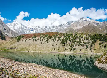
The Karakoram Highway is Pakistan’s most celebrated mountain road, running north from the plains near Hasan Abdal through Khyber Pakhtunkhwa and Gilgit-Baltistan towards the Khunjerab Pass on the Chinese frontier. Often described as part of the modern Silk Road, it crosses an immense succession of landscapes: the foothills around Abbottabad and Mansehra, the deep Indus gorge near Besham and Chilas, the high valleys of Gilgit-Baltistan, and the stark alpine country around the Khunjerab National Park. The road is not a single scenic attraction but a long journey whose character changes repeatedly with altitude, geology and climate.Read more about Karakoram Highway
Valleys, Peaks and Living Heritage
A Journey Rather Than a Single Stop
When is the best time to visit Karakoram Highway?
Best: June–August · 24–26°C| Month | High (°C) | Rainfall (mm) |
|---|---|---|
| January | 2 | 1 |
| February | 5 | 1 |
| March | 8 | 2 |
| April | 14 | 4 |
| May | 19 | 5 |
| June (best) | 24 | 6 |
| July (best) | 26 | 8 |
| August (best) | 25 | 7 |
| September | 20 | 5 |
| October | 14 | 4 |
| November | 6 | 2 |
| December | 2 | 1 |
Getting to and around Karakoram Highway
How to get there
Transportation
Best attractions in Karakoram Highway
-
Tourist attraction
Kunhar Valley View Point, Dana Top
Experience the breathtaking beauty of Kunhar Valley View Point, a serene escape in Khyber Pakhtunkhwa, offering stunning panoramic views and nature's tranquility.
-
Tourist attraction
Rupal Valley
Explore Rupal Valley, a breathtaking treasure in Gilgit-Baltistan, known for its majestic landscapes and serene trekking adventures.
-
Tourist attraction
Sharan Waterfall
Discover the breathtaking Sharan Waterfall in Khyber Pakhtunkhwa, where nature's beauty and tranquility come together for an unforgettable adventure.


Explore Karakoram Highway on the map
Plan your trip on one map. See where the top attractions, landmarks, restaurants and hotels are, and book hotels and experiences in a few clicks.
Best hotels in Karakoram Highway
Best restaurants in Karakoram Highway
Food along the Karakoram Highway is shaped by altitude, local agriculture and the cultures of the mountain valleys. Roadside eateries and small restaurants in larger settlements serve familiar Pakistani dishes such as chapati, rice, lentils, kebabs and regional meat preparations, while Hunza is associated with apricots, walnuts, mulberries, potatoes and other produce grown in irrigated terraces. In Hunza and Gilgit, visitors may encounter local foods including chapshuro, a filled pastry associated with the region, as well as simple noodle, bread and soup dishes influenced by northern mountain traditions. Cafés and hotel dining rooms are concentrated in Gilgit, Karimabad, Gulmit and other established visitor bases; meals become simpler and choices narrower on remote stretches. Carrying snacks is sensible for long road stages, and travellers should ask about ingredients when eating in small family-run establishments.
-
Restaurant
Khunjarab Wild Garden Restaurant & Camping Site Toqroqeen
Experience delightful local cuisine amidst breathtaking landscapes at Khunjarab Wild Garden Restaurant & Camping Site in Gilgit-Baltistan.

Get your free copy of our complete guide to Karakoram Highway, delivered straight to you.
Everything on this page, from attractions and restaurants to essentials and local phrases, in one PDF you can read offline, print or share.
Already have an account? Sign in
Your Karakoram Highway guide is ready.
We'll send it to · Not you? Sign out

Getting your guide ready…
We are putting together a fresh copy of the Karakoram Highway guide. This can take up to a minute.
This can take a few moments. If your browser asks, choose Allow so the download can start. You'll find the guide in your Downloads folder.
Nothing happened? Download it again
Sorry, the guide is taking longer than usual. Please try again in a minute, or get it by email instead.
Karakoram Highway essentials
Currency and Payment
Safety
Emergency Situations
Do's and Don'ts
Local Tips
From Eve
Local phrases worth knowing
You don't need to get them perfect. A few words go a long way, and locals appreciate the effort.
Basics
| English | Local | Say it |
|---|---|---|
| Hello | سلام | [salaam] |
| Goodbye | خدا حافظ | [khuda hafiz] |
| Yes | ہاں | [haan] |
| No | نہیں | [nahin] |
| Please/You're welcome | براہ کرم | [barah e karam] |
| Thank you | شکریہ | [shukriya] |
| Excuse me/Sorry | معاف کیجیے | [maaf kijiye] |
| How are you? | آپ کیسے ہیں؟ | [aap kaise hain?] |
| Fine. And you? | ٹھیک ہوں. آپ سنا؟ | [theek hoon. aap suna?] |
| Do you speak English? | کیا آپ انگریزی بولتے ہیں؟ | [kya aap angrezi boltay hain?] |
| I don't understand | مجھے سمجھ نہیں آیا | [mujhe samajh nahi aya] |
Eating & Drinking
| English | Local | Say it |
|---|---|---|
| I'd like to see the menu, please | براہ کرم مینو دیکھنا ہے | [barah e karam menu dekhna hai] |
| I don't eat meat | میں گوشت نہیں کھاتا | [mein gosht nahi khata] |
| Cheers! | صحت | [sehat] |
| I would like to pay, please | براہ کرم ادا کرنا ہے | [barah e karam ada karna hai] |
Emergencies
| English | Local | Say it |
|---|---|---|
| Help! | مدد! | [madad!] |
| Go away! | نکل جاؤ! | [nikal jao!] |
| Call the Police! | پولیس کو بلاؤ! | [police ko bulao!] |
| Call a doctor! | ڈاکٹر کو بلاؤ! | [doctor ko bulao!] |
| I'm lost | میں گم ہو گیا ہوں | [mein gum ho gaya hoon] |
| I'm ill | میں بیمار ہوں | [mein bimar hoon] |
Shopping
| English | Local | Say it |
|---|---|---|
| I'd like to buy... | میں خریدنا چاہتا ہوں... | [mein khareedna chahta hoon...] |
| I'm just looking | میں صرف دیکھ رہا ہوں | [mein sirf dekh raha hoon] |
| How much is it? | یہ کتنا ہے؟ | [ye kitna hai?] |
| That's too expensive | یہ بہت مہنگا ہے | [ye bohat mehnga hai] |
| Can you lower the price? | کیا آپ قیمت کم کرسکتے ہیں؟ | [kya aap qeemat kam kar sakte hain?] |
Time & Numbers
| English | Local | Say it |
|---|---|---|
| What time is it? | کتنا بجا ہوا ہے؟ | [kitna baja hua hai?] |
| It's one o'clock | ایک بجا ہے | [aik baja hai] |
| Half past (10) | دس بج کر پندرھ منٹ ہے | [das baj kar pandrah mint hai] |
| Morning | صبح | [subah] |
| Afternoon | دوپہر | [dopehar] |
| Evening | شام | [shaam] |
| Yesterday | گزشتہ کل | [guzishta kal] |
| Today | آج | [aaj] |
| Tomorrow | کل | [kal] |
| 1 | ایک | [aik] |
| 2 | دو | [do] |
| 3 | تین | [teen] |
| 4 | چار | [chaar] |
| 5 | پانچ | [paanch] |
| 6 | چھے | [chhe] |
| 7 | سات | [saat] |
| 8 | آٹھ | [aath] |
| 9 | نو | [no] |
| 10 | دس | [das] |
Transport & Directions
| English | Local | Say it |
|---|---|---|
| Where's a/the...? | کہاں ہے...؟ | [kahan hai...?] |
| What's the address? | پتہ کیا ہے؟ | [pata kya hai?] |
| Can you show me (on the map)? | کیا آپ مجھے دکھا سکتے ہیں؟ | [kya aap mujhe dikhha sakte hain?] |
| When's the next (bus)? | اگلی (بس) کب ہے؟ | [agli (bus) kab hai?] |
| A ticket (to ....) | ایک ٹکٹ (سے ....) | [aik ticket (se ....)] |
History of Karakoram Highway
Ancient Routes Across the Mountains
The corridor followed by the modern Karakoram Highway belongs to a much older network of paths linking the Indian subcontinent with Central Asia and China. Caravans, pilgrims, traders and local communities used mountain passes and valley routes rather than one continuous engineered road. Gilgit-Baltistan’s position between the Hindu Kush, Karakoram and western Himalaya encouraged contact among different peoples, while rivers and narrow valleys concentrated settlement in otherwise rugged terrain. The route’s Silk Road association is therefore best understood as a broad historical connection rather than evidence of a single ancient highway following precisely the modern alignment.
Mountain Kingdoms and Regional Cultures
Before modern state infrastructure, the upper valleys were governed through a mixture of local rulers, village communities and small mountain kingdoms. Hunza, Nagar, Gilgit and Baltistan each developed distinctive political and cultural traditions, while trade and migration connected them with Kashmir, Afghanistan, Central Asia and the regions to the east. Fortified residences such as Baltit and Altit reflect the strategic importance of Hunza’s valley routes. The modern highway passes through communities whose languages, architecture, agriculture and religious traditions remain closely connected to these earlier regional identities.
The Northern Frontier in the Modern Era
The northern mountain regions became increasingly important to British India during the nineteenth and early twentieth centuries because of their position near the frontiers of Afghanistan, Xinjiang and the princely states. Gilgit developed as an administrative and strategic centre, while routes through the mountains were surveyed and improved for military and political purposes. After the creation of Pakistan in 1947, the remote northern areas remained difficult to reach from the south. Transport was commonly dependent on narrow roads, tracks and air links, reinforcing the isolation of many valleys.
Building the Karakoram Highway
Construction of the modern highway began in the 1960s through cooperation between Pakistan and China and continued for more than a decade. The route required extensive surveying, bridge building, tunnelling and road cutting through unstable mountain terrain, with the loss of many workers during the project. It was opened to public traffic in the late 1970s and formally inaugurated in 1979. By linking Pakistan’s northern areas with the Khunjerab Pass and China, the road transformed trade, administration, communications and access to education, healthcare and tourism across communities that had previously been separated by difficult terrain.
Landscape Change and Tourism
The highway has brought economic opportunity and far greater visibility to destinations such as Hunza, Gilgit and Passu, while also increasing traffic, construction and pressure on water, waste and fragile mountain environments. The 2010 Attabad landslide in Hunza blocked the Hunza River and created Attabad Lake, temporarily severing the road and prompting the construction of tunnels and a lakeside realignment. Today, road maintenance, disaster response and environmental management remain central to travel along the corridor. Tourism is now an important part of the regional economy, alongside agriculture, trade, transport and public services.
Karakoram Highway in Photos
Browse through our photo collection highlighting the charm and character of the destination.
Neighbouring destination travel guides
The closest destinations to Karakoram Highway, if you have time for more than one.
-

-

-

-
-


Swipe for more destinations
Explore more

Explore more of Hunza Valley
Explore Hunza Valley in Pakistan for Karakoram views, historic forts, orchard villages, Attabad Lake and high mountain journeys.
Explore Hunza Valley
Explore more of Pakistan
Discover Pakistan: A land of majestic mountains, rich history, and delicious cuisine, where every journey is an adventure and every moment is filled with wonder.
Explore Pakistan