

Salkantay Trail Travel Guide - Free Web & App
Your ultimate guide to Salkantay Trail. Discover top landmarks, proposed trips, and local tips. Free on the web or via the Evendo companion app.


Hike Peru’s Salkantay Trail from glacial lakes and high Andes passes through cloud forest to Machu Picchu, with mountain scenery and Quechua heritage.
Across Peru’s Changing Landscapes
The Salkantay Trail is one of Peru’s great long-distance trekking routes, linking the high-altitude landscapes south of Cusco with Machu Picchu and the cloud forests of the eastern Andes. Its name comes from Salkantay, or Sallqantay, a major snow-capped peak of the Vilcabamba range whose Quechua name is commonly associated with wildness or savagery. The route is not a single uniformly fixed path: itineraries vary, usually taking between four and seven days and passing through mountain passes, glacial lakes, rural settlements, coffee-growing valleys and subtropical forest before reaching the Inca citadel.Read more about Salkantay Trail
From Glacial Terrain to Cloud Forest
Approaching Machu Picchu
When is the best time to visit Salkantay Trail?
Best: September–November · 15–17°C| Month | High (°C) | Rainfall (mm) |
|---|---|---|
| January | 17 | 80 |
| February | 16 | 70 |
| March | 16 | 70 |
| April | 15 | 60 |
| May | 14 | 50 |
| June | 13 | 40 |
| July | 13 | 40 |
| August | 14 | 40 |
| September (best) | 15 | 50 |
| October (best) | 16 | 60 |
| November (best) | 17 | 70 |
| December | 18 | 80 |
Getting to and around Salkantay Trail
How to get there
Transportation
Best attractions in Salkantay Trail
-
Tourist attraction
Intipata
Explore Intipata, a breathtaking archaeological site along the Inca Trail, famous for its stunning terraces and rich Incan heritage.
-
Farmstay
CAÑON DEL APURIMAC
Discover the breathtaking beauty and rich cultural heritage of Cañon del Apurimac in Curahuasi, Peru—a paradise for nature and adventure enthusiasts.

Best landmarks in Salkantay Trail
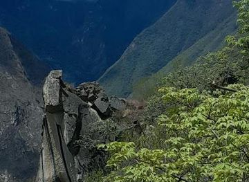
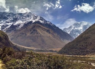
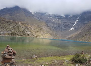
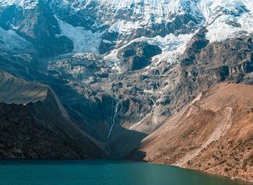
The Salkantay Pass is the route’s defining natural landmark, a high mountain crossing beneath the Salkantay massif where the austere puna gives way to deep eastern valleys. Humantay Lake is another prominent feature, notable for its clear turquoise appearance and setting below snow-covered peaks, although access involves a demanding uphill walk. Further downhill, the transition into cloud forest marks a dramatic ecological boundary, with steep slopes, streams and cultivated terraces replacing the open highlands. The route ultimately connects with the historic landscape of Machu Picchu, the fifteenth-century Inca citadel built on a mountain saddle above the Urubamba valley. The railway at Hidroeléctrica and the settlement of Aguas Calientes are modern access landmarks rather than ancient monuments, illustrating how contemporary transport and tourism have reshaped the approach to the archaeological site.
-
Mountain peak
Salcantay
Explore the breathtaking beauty of Salcantay, Peru's majestic mountain peak, offering unforgettable trekking experiences and stunning Andean vistas.
-
Hiking area
Montaña Salkantay
Explore the breathtaking trails of Salkantay Mountain, where adventure meets stunning natural beauty in the heart of the Peruvian Andes.
-
Tour operator
Sky High Expeditions
Experience the breathtaking Andes with Sky High Expeditions, your premier adventure tour operator for hiking, climbing, and skiing in Salkantay, Cusco.
-
Hiking area
Laguna Salkantay
Discover the breathtaking beauty of Laguna Salkantay, a stunning hiking area in the Andes, perfect for adventure seekers and nature enthusiasts.
Explore Salkantay Trail on the map
Plan your trip on one map. See where the top attractions, landmarks, restaurants and hotels are, and book hotels and experiences in a few clicks.
Best hotels in Salkantay Trail
Get your free copy of our complete guide to Salkantay Trail, delivered straight to you.
Everything on this page, from attractions and restaurants to essentials and local phrases, in one PDF you can read offline, print or share.
Already have an account? Sign in
Your Salkantay Trail guide is ready.
We'll send it to · Not you? Sign out

Getting your guide ready…
We are putting together a fresh copy of the Salkantay Trail guide. This can take up to a minute.
This can take a few moments. If your browser asks, choose Allow so the download can start. You'll find the guide in your Downloads folder.
Nothing happened? Download it again
Sorry, the guide is taking longer than usual. Please try again in a minute, or get it by email instead.
Salkantay Trail essentials
Currency and Payment
Safety
Emergency Situations
Do's and Don'ts
Local Tips
From Eve
Local phrases worth knowing
You don't need to get them perfect. A few words go a long way, and locals appreciate the effort.
Basics
| English | Local | Say it |
|---|---|---|
| Hello | Sawasiray | [sah-wah-see-rye] |
| Goodbye | Sulpayki | [sool-pie-kee] |
| Yes | Arí | [ah-ree] |
| No | Mana | [mah-nah] |
| Please/You're welcome | Sulpay | [sool-pie] |
| Thank you | Sulpayki | [sool-pie-kee] |
| Excuse me/Sorry | Pachamama | [pah-cha-mah-mah] |
| How are you? | Allillanchu? | [ah-lee-yee-yahn-choo] |
| Fine. And you? | Allillanmi. Ima sutiyki? | [ah-lee-yee-yahn-mee. ee-mah soo-tee-kee] |
| Do you speak English? | Inglis rimaqta munanki? | [een-glees ree-mahk-tah moo-nahn-kee] |
| I don't understand | Mana rikurichkani | [mah-nah ree-koo-reech-kah-nee] |
Eating & Drinking
| English | Local | Say it |
|---|---|---|
| I'd like to see the menu, please | Menuyta rimani kanki, sulpay | [meh-noo-ee-tah ree-mah-nee kahn-kee, sool-pie] |
| I don't eat meat | Karnirunmi mana mikuni | [kahr-nee-roon-mee mah-nah mee-koo-nee] |
| Cheers! | Kanpai! | [kahn-pie] |
| I would like to pay, please | Yanapayta rimani kanki, sulpay | [yah-nah-pie-tah ree-mah-nee kahn-kee, sool-pie] |
Emergencies
| English | Local | Say it |
|---|---|---|
| Help! | Yanapay! | [yah-nah-pie] |
| Go away! | Imaynataq! | [ee-mah-een-ah-tahk] |
| Call the Police! | Pulisi wikanki! | [poo-lee-see wee-kahn-kee] |
| Call a doctor! | Waqaychikuy! | [wah-kie-chee-koo-ee] |
| I'm lost | Kashan | [kah-shahn] |
| I'm ill | Sonqoyki | [sohn-koh-ykee] |
Shopping
| English | Local | Say it |
|---|---|---|
| I'd like to buy... | Suyayta rimani | [soo-yie-tah ree-mah-nee] |
| I'm just looking | Suyayniyki | [soo-yie-nee-ykee] |
| How much is it? | Imaynataq? | [ee-mah-een-ah-tahk] |
| That's too expensive | Qhali kay? | [kyah-lee kie] |
| Can you lower the price? | Qhali kayta kichariyki? | [kyah-lee kie-tah kee-chah-ree-kee] |
Time & Numbers
| English | Local | Say it |
|---|---|---|
| What time is it? | Imaynataq waqta? | [ee-mah-een-ah-tahk wahk-tah] |
| It's one o'clock | Huk waqta | [hook wahk-tah] |
| Half past (10) | Iskay waqta (10) | [ees-kie wahk-tah (d-ee-ss)] |
| Morning | P'unchaw | [poon-chahw] |
| Afternoon | Ch'aski | [chahs-kee] |
| Evening | Tuta | [too-tah] |
| Yesterday | Illakuy | [ee-yah-koo-ee] |
| Today | Kunan | [koo-nahn] |
| Tomorrow | Kay | [kie] |
| 1 | Huk | [hook] |
| 2 | Iskay | [ees-kie] |
| 3 | Kinsa | [keen-sah] |
| 4 | Tawa | [tah-wah] |
| 5 | Pisqa | [pees-kah] |
| 6 | Phisqa | [fees-kah] |
| 7 | Qanchis | [kahn-chees] |
| 8 | Pusaq | [poo-sahk] |
| 9 | Isqun | [ees-koon] |
| 10 | Chunka | [choon-kah] |
Transport & Directions
| English | Local | Say it |
|---|---|---|
| Where's a/the...? | ...pi? | [pee] |
| What's the address? | Nishut uchari? | [neesh-oot oo-chah-ree] |
| Can you show me (on the map)? | Mapapi kicharayki? | [mah-pah-pee kee-chah-rah-ee-kee] |
| When's the next (bus)? | Kaynataq sami (bus)? | [kie-nah-tahk sah-mee (boos)] |
| A ticket (to ....) | Pikiti (....manta) | [pee-kee-tee (mahn-tah)] |
History of Salkantay Trail
The Vilcabamba Mountain World
The Salkantay Trail crosses the Vilcabamba mountain range, a rugged chain forming part of the eastern Andes of southern Peru. Its steep valleys, snow-covered summits and forests descending towards the Amazon basin created sharp ecological zones that shaped movement and settlement over centuries. Salkantay is a prominent sacred mountain in the regional Quechua landscape, although the modern trekking route should not be presented as a single documented Inca road. Rather, contemporary itineraries bring together local paths, rural roads and sections of established access routes across an ancient mountain environment.
Inca Landscapes near Cusco
The wider region was connected to the Inca imperial world centred on Cusco, whose roads, terraces, settlements and administrative networks extended through the Andes. The principal archaeological destination associated with the trail is Machu Picchu, built in the fifteenth century during the period of Inca expansion and occupation. The route itself approaches Machu Picchu from the south-west and should be distinguished from the Inca Trail, the separately regulated route that enters the citadel through the Sun Gate. Rural communities along the Salkantay corridor continue to reflect Quechua agricultural traditions and mountain livelihoods.
Colonial and Republican Change
Spanish conquest and colonial rule altered landholding, religion, labour systems and settlement patterns throughout the Cusco region. Highland communities adapted to new institutions while continuing agricultural practices suited to different elevations. Over the colonial and republican periods, trails and mule routes remained important for connecting dispersed settlements and moving crops between cold uplands and warmer valleys. Much of the country crossed by modern Salkantay itineraries remained rural and difficult to access, with local economies based on farming, livestock, forest products and, in lower areas, crops such as coffee and fruit.
Machu Picchu and the Growth of Trekking
Machu Picchu became internationally prominent after its 1911 exposure to wider academic and public attention, although local residents already knew the site. Rail access and the development of tourism gradually transformed the surrounding valleys, while Cusco became the principal base for visitors. The Salkantay route expanded as an alternative to the more tightly regulated Inca Trail, offering a longer journey through high mountain and cloud-forest environments. Its popularity has brought income to guides, muleteers, cooks, homestays and rural communities, while also increasing pressure on paths, waste management and local resources.
Conservation and Contemporary Management
The trail’s landscapes overlap with areas of high ecological sensitivity, including glacial terrain, puna grassland, cloud forest and steep river valleys. Machu Picchu and its surrounding sanctuary are protected through Peru’s heritage and conservation framework, while local authorities and communities manage access and services along different sections of the wider trekking corridor. Modern challenges include changing weather patterns, retreating glaciers, erosion, visitor pressure and the need to balance tourism income with environmental protection. Conditions, route arrangements and entry requirements can change, so trekkers should consult current official guidance before departure.
Salkantay Trail in Photos
Browse through our photo collection highlighting the charm and character of the destination.
Neighbouring destination travel guides
The closest destinations to Salkantay Trail, if you have time for more than one.
-

-

-

-

-


Swipe for more destinations
Explore more

Explore more of Apurímac
Discover Apurímac: Peru's hidden gem with stunning landscapes, rich cultural heritage, and thrilling adventures, perfect for nature enthusiasts and history buffs alike.
Explore Apurímac
Explore more of Peru
Discover the wonders of Peru: ancient ruins, stunning landscapes, and a vibrant culture that will captivate your heart and soul.
Explore Peru