Background

Glen Ogle: A Historic Highland Valley of Scenic Trails and Engineering Marvels

Explore Glen Ogle’s rugged beauty, historic military roads, and iconic Victorian viaducts on scenic hiking and cycling trails near Crianlarich.

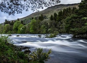
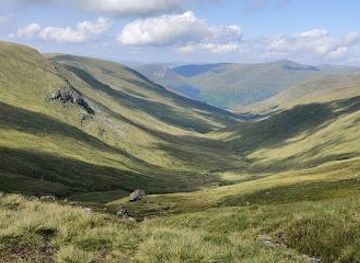
Glen Ogle is a stunning 7-mile glen near Crianlarich in Scotland, known for its dramatic landscapes, historic military roads, and remarkable Victorian railway viaducts. Once a drovers' route and a military road corridor, it now offers hikers and cyclists a scenic trail through crags, forests, and open countryside. The glen’s evocative name, possibly meaning 'valley of dread,' reflects its rugged past and wild beauty, making it a captivating destination for nature lovers and history enthusiasts alike.

Plan your visit

A brief summary to Glen Ogle

Opening times, essentials, and a few local tips gathered into one calmer, easier-to-scan planning section.

Plan your visit

📍
Crianlarich, GB
🕒
Duration: 3 to 5 hours
💷
Free
🏛
Outdoor
📶
Mobile reception: 4 out of 5

Explore places near Glen Ogle

    See all →

    Unlock the Best of Glen Ogle

    Find tickets, tours with entry, and experiences available for this location.

    Buy tickets

    No tickets available

    Book tours with entry

    No tours with entry available

    Book tours without entry

    No tours without entry available

    Getting There

    By Car

    Drive from Crianlarich to Lochearnhead via the A85, a scenic 15-minute journey covering approximately 12 miles. Parking is available at the Lochearnhead car park near the trailhead. Note that road conditions can be narrow and winding; drive cautiously especially in winter.

    By Bus

    Take the C60/S60 bus service from Crianlarich to Lochearnhead, which runs several times daily. The journey takes about 30-40 minutes. Check the local bus timetable as services may be less frequent on weekends and holidays.

    By Train and Walk

    Arrive at Crianlarich railway station via the West Highland Line. From Crianlarich, take a local taxi or cycle approximately 12 miles east along the A85 to Lochearnhead, where the Glen Ogle trail begins.

    For the on-the-go comforts that matter to you

    Restrooms
    Seating Areas
    Trash Bins
    Information Boards
    Visitor Center

    Local tips

    Wear sturdy waterproof footwear as some trail sections, especially the old military road return path, can be boggy and overgrown.
    Bring a camera to capture the stunning 12-arched Glen Ogle viaduct and the dramatic Highland landscapes.
    Start your hike or cycle from Lochearnhead car park, which offers restroom facilities and easy access to the trail.
    Look out for local wildlife such as red deer, mountain hares, and otters along the trail, especially near streams.
    Check weather forecasts before visiting; Scottish weather can change quickly, affecting trail conditions and visibility.

    Glen Ogle location weather suitability

    Catch the right light and the right mood, whether you want a bright city moment or a more cinematic evening visit.

    Weather icon
    Any Weather
    Weather icon
    Rain / Wet Weather
    Weather icon
    Clear Skies
    Weather icon
    Windy Conditions
    Weather icon
    Mild Temperatures

    Discover more about Glen Ogle

    Historic Pathways Through a Highland Glen

    Glen Ogle stretches approximately 7 miles from Lochearnhead northwest to Lix Toll, where it opens into Glen Dochart. Historically, it served as a crucial drovers' road and was part of General Wade’s military roads network, constructed in the 18th century to facilitate British Army movements through the challenging and often hostile Highland terrain. Remnants of these military roads, including small stone bridges dating back to around 1750, still survive and can be spotted along the route, offering a tangible link to Scotland’s military past.

    Victorian Engineering: The Glen Ogle Viaducts

    In the 1860s, Glen Ogle became part of the ambitious Callander & Oban Railway project, which aimed to connect central Scotland to the west coast port of Oban. To overcome the difficult landscape, engineers built two stone viaducts: one with three arches and a larger, more impressive twelve-arched viaduct. These rock-faced stone structures remain remarkably well-preserved and are iconic features of the glen, now repurposed as part of a cycling and walking trail. The railway itself ceased operation after a landslip closed the line, but the viaducts stand as enduring monuments to Victorian engineering prowess.

    Natural Beauty and Wildlife of Glen Ogle

    The glen’s terrain is a tapestry of rugged crags, dense forests, and open green spaces, creating a habitat rich in wildlife. Visitors might encounter mountain hares, red deer, foxes, otters, and badgers, as well as a variety of birds and insects. The trail follows the old railway line, passing by streams and stone bridges, offering a peaceful and scenic experience. The landscape’s wild character is heightened by the often variable Scottish weather, which can shift between sunshine and rain, adding to the glen’s atmospheric charm.

    Walking and Cycling Routes in Glen Ogle

    Today, Glen Ogle is a popular destination for hikers and cyclists. The trail along the former railway line extends about 8 miles and is part of the national Cycle Route 7, which runs from Sunderland to Inverness. It also intersects with the Rob Roy Way, a long-distance trail named after the famous Scottish folk hero. The route includes paved tracks and forest trails, though some sections can be boggy and overgrown, especially on the return path that follows the old military road. A complete walk or cycle through the glen typically takes around 4 hours, rewarding visitors with stunning views and a sense of stepping back in time.

    Glen Ogle’s Place in Scottish Heritage and Landscape

    The glen’s name may derive from the Gaelic "gleann-eagal," meaning "valley of dread," reflecting its formidable terrain and historical significance as a strategic passage. Queen Victoria famously likened Glen Ogle to the Khyber Pass of Scotland, underscoring its dramatic and imposing nature. Its location near Crianlarich, a key Highland gateway village, situates Glen Ogle within a rich network of natural and cultural attractions, including nearby Munros, waterfalls, and historic sites, making it a vital part of Scotland’s outdoor and heritage tourism.

    Visitor Experience and Seasonal Considerations

    Visitors to Glen Ogle can enjoy a blend of history, nature, and outdoor adventure. The glen is accessible year-round, though weather conditions can greatly affect trail conditions, with wet and boggy areas common after rain. Facilities like a car park with restrooms are available near Lochearnhead, the usual starting point for walks. The tranquil and scenic environment provides a peaceful escape, with opportunities for wildlife spotting and photography. The glen’s combination of natural beauty and historical depth offers a uniquely Scottish experience for all types of travelers.

    A brief summary to Glen Ogle

    Use Tower Bridge as your starting point for nearby food, family ideas, nightlife, and more local discoveries.

    Plan around the quieter times

    A quick look at seasonal patterns and peak visiting hours.

    Busiest months of the year

    Seasonality

    Busiest hours of the day

    Footfall
    Mobile App
    Get the app

    Your all‑in‑one travel companion app

    Explore expert travel guides, compare and book tours, experiences, hotels, and more—all from the palm of your hand. Download now for seamless trip planning wherever your wanderlust takes you.

    Mynd:Edinburgh Castle from the south east.JPG - Wikipedia, frjálsa  alfræðiritið

    More about Scotland

    Discover the magic of Scotland: stunning landscapes, historic castles, vibrant cities, and world-famous whisky. An unforgettable journey awaits in this enchanting land.

    Tell me more about Scotland

    Select Currency

    Choose the currency you want prices to display in.