Pikkerbakken Viewpoint
Forest-framed hilltop with a striking airwalk, sweeping Kattegat views and quiet wartime relics above the harbor town of Frederikshavn.
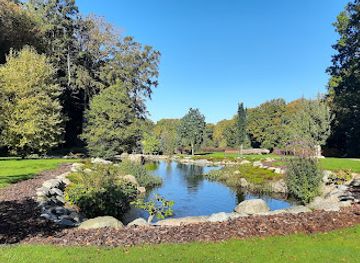
Pikkerbakken is a forested hilltop viewpoint rising about 71 meters above sea level on the southern edge of Frederikshavn. A striking steel-and-wood platform and airwalk project out toward the Kattegat, giving wide-open views across the town, harbor, and out to Hirsholmene and Læsø on clear days. Walking and MTB trails lace through Bangsbo forest, while remnants of Second World War bunkers hint at the site’s former military importance. It is free, always open, and feels close to nature yet just minutes from town.
A brief summary to Pikkerbakken
- Dronningestien, Frederikshavn, 9900, DK
- Duration: 0.5 to 3 hours
- Free
-
Outdoor
- Mobile reception: 4 out of 5
- Monday 12 am-12 am
- Tuesday 12 am-12 am
- Wednesday 12 am-12 am
- Thursday 12 am-12 am
- Friday 12 am-12 am
- Saturday 12 am-12 am
- Sunday 12 am-12 am
Local tips
- Aim for clear weather if you want to see Hirsholmene and Læsø; low clouds or sea mist can significantly shorten the view.
- Bring layers, as wind on the exposed platform can feel noticeably cooler than in the forest or down in town.
- If driving, be prepared for an unpaved access stretch and limited parking; consider parking lower down and walking the final ascent.
- Combine the viewpoint with a walk through Bangsbo forest or a visit to Bangsbo Fort to explore the wartime bunkers in more detail.
- Photographers should try sunrise or late evening light for the most atmospheric shots over the harbor and coastline.
For the on-the-go comforts that matter to you
- Picnic Areas
- Information Boards
- Trash Bins
- Seating Areas
Getting There
-
Car from central Frederikshavn
From central Frederikshavn it typically takes 10–15 minutes to reach the Pikkerbakken area by car. The final stretch includes a narrow, partly unpaved forest road where you need to drive slowly and be mindful of pedestrians and cyclists. Parking near the top is free but limited, so at busy times you may need to leave the car lower down and walk the last uphill section on foot.
-
Local bus plus walk
City buses serving the Bangsbo area run from central Frederikshavn in roughly 10–20 minutes, with tickets usually costing in the range of 20–30 DKK for a single adult within the local zone. From stops near Bangsbo facilities, expect an additional 25–40 minutes of uphill walking on forest paths and paved lanes. Surfaces can be uneven, so sturdy footwear is recommended and the route is less suitable for those with limited mobility.
-
Cycling from town
A bicycle ride from central Frederikshavn to the foot of Pikkerbakken generally takes 20–30 minutes, starting out on ordinary town streets before climbing into the Bangsbo forest area. The final ascent is short but steep, popular with local cyclists and requiring low gears and reasonable fitness. There is no specific bike parking infrastructure at the viewpoint itself, so bring a lock and be prepared to leave your bike just off the track.
-
Hiking through Bangsbo forest
For a more immersive approach, many visitors start in the Bangsbo area and follow marked forest trails uphill to Pikkerbakken, allowing about 60–90 minutes each way depending on route and pace. Paths can be muddy after rain, with roots and rocks underfoot, so waterproof shoes and weather-appropriate clothing are advisable. This option gives access to bunkers, clearings and viewpoints along the way but is not ideal in high winds or icy winter conditions.
Pikkerbakken location weather suitability
-
Clear Skies
-
Mild Temperatures
-
Cold Weather
-
Any Weather
-
Windy Conditions
Discover more about Pikkerbakken
Clifftop panorama above Frederikshavn
Pikkerbakken crowns the southern rim of Frederikshavn, a wooded ridge that suddenly drops toward the Kattegat coast. From the main platform, you stand roughly 71 meters above sea level, with an uninterrupted sweep over the red roofs of town, the busy ferry harbor and the open water beyond. On days with clear air the line of the horizon sharpens and you can pick out the islands of Hirsholmene and, further away, Læsø sitting low in the sea. The light here is constantly shifting. Early in the morning it comes in soft from the east across the water, while in the evening the sun slides down behind the forested hinterland, silhouetting cranes, ferries and wind turbines. The sense of height is accentuated by the steep forested slopes that fall away just below the railings, giving you the feeling of standing between town and wilderness.A modern airwalk over an ancient slope
The most eye-catching feature at Pikkerbakken is the contemporary viewing platform and airwalk. Built of steel and timber, it projects out from the hillside like a stylised outline of Skagens Gren, Denmark’s northern tip. Stepping onto the airwalk, you move a little way beyond the safety of the cliff, looking straight down at the treetops and rocky slope beneath your feet while the harbor spreads out ahead. Design details are deliberately minimalist: simple lines, open railings and a restrained palette that allows the big view to dominate. In contrast, the surroundings remain rugged and natural, with patches of heather, exposed rock and wind-shaped trees reminding you that this was once an untamed coastal slope long before platforms and paths appeared.War bunkers in the quiet forest
Hidden among the trees behind the viewpoint are concrete traces of a very different era. During the Second World War, German forces used the height of Pikkerbakken to monitor shipping routes in the Kattegat. A network of bunkers, gun positions and installations was built into the hillside, forming part of a wider defensive complex together with nearby Bangsbo Fort. Today, many of these structures sit moss-covered and silent between birch and pine. Some are fenced or sealed, others can be viewed from the outside along forest tracks. They add a layer of atmosphere to a walk in the woods, turning a simple stroll into a quiet encounter with twentieth‑century history in the middle of otherwise peaceful nature.Forest trails, bike climbs and picnic corners
The surrounding Bangsbo forest makes Pikkerbakken more than just a quick photo stop. Waymarked walking routes wind up from the valley, including paths linking to Møllehuset and the Bangsbo museums, while a short but steep cycling climb draws local riders looking for a taste of elevation in otherwise gentle North Jutland. The combination of gradient, curves and views has made the hill a small classic in regional cycling circles. Near the top you find simple picnic spots with tables, typically placed to catch both sun and scenery. On calm days it is easy to linger with a thermos and sandwiches as ships come and go far below. Even when the breeze picks up, the trees just behind the edge provide shelter, and a few steps back from the railings the forest quickly closes around you again.Atmosphere through seasons and light
Pikkerbakken feels different with every season. In spring, new leaves brighten the slopes and the forest floor is dotted with wildflowers. Summer brings long, pale evenings when you can watch the town lights appear one by one. Autumn wraps the valley in muted reds and golds, while in crisp winter weather, clear skies can make the view over the cold blue Kattegat especially sharp. There is no admission or closing time, so you can time your visit to the moods you prefer: a solitary sunrise, a breezy midday stop during a day in Bangsbo, or a blue‑hour visit when ferries glide in under a darkening sky. Whatever the moment, the blend of coastal panorama, forest quiet and subtle history gives this modest hilltop an appeal far larger than its height suggests.For the vibe & atmosphere seeker
- Scenic
- Tranquil
- Relaxing
- Unique
- Adventurous
For the design and aesthetic lover
- Minimalist Designs
- Rustic Designs
For the architecture buff
- Viewpoints
- Parks & Gardens
- Historic
- Landmarks
For the view chaser and sunset hunter
- Iconic Views
- Panoramas
- Sunrise Spots
- Sunset Spots
For the social media creator & influencer
- Photo Spots
- Selfie Spots
- Reel-Friendly
- Architectural Shots
- Instagrammable
For the eco-conscious traveler
- Low Impact
- Public-Transport Accessible
- Leave-No-Trace Critical
- Wildlife Habitat
For the kind of experience you’re after
- Photowalk
- Adventure Photo Shoot
- Nature Escape
- Day Trip
- Roadtrip Stop
- Cultural Heritage
- Mindfulness
For how adventurous you want the journey to be
- Easy Access
- Requires Hike
Location Audience
- Family Friendly
- Senior Friendly
- Child Friendly
- Teen Friendly
- Solo Friendly
- Couple Friendly
- Solo Female Friendly