Background

Radar Station Koldekrig, Røsnæs

Cold War concrete hidden in a wild coastal landscape, where underground radar rooms once scanned Storebælt and today’s visitors pair military history with sea views.
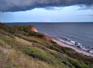
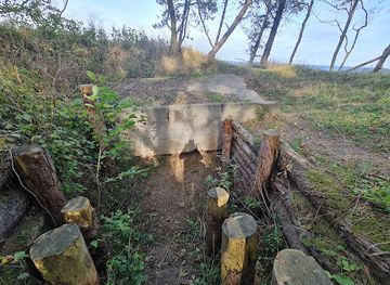
Cold War eyes on Storebælt

Hidden in the slopes near the tip of the Røsnæs peninsula, Radar Station Koldekrig was part of Denmark’s early Cold War defence line, watching the narrow waters between Zealand and Funen. From the early 1950s until the mid‑1960s, naval personnel worked here in shifts, operating radar that tracked ship movements and helped coordinate Danish fast attack craft in case of a crisis. The station replaced German World War II positions on the same heights, taking over a proven vantage point with sweeping views across Storebælt. Where German spotters once scanned the horizon with binoculars and simple radar, Danish crews now relied on more advanced British‑made equipment housed in a new, deeply dug concrete bunker.

An underground world beneath the grass

From above, the site looks almost modest: low mounds, ventilation pipes and heavy doors cut into the hillside. Beneath your feet, though, lies a compact warren of rooms where up to a few dozen people could work, sleep and shelter. Inside were the radar operations room, communication posts, dormitories, a tiny kitchen and emergency power supplies, all protected by thick walls and blast doors salvaged from German wartime structures. Though the operational equipment has long since been removed, the shape of the installation is still easy to read. Turf‑covered roofs blend it into the landscape, a deliberate choice at a time when avoiding enemy detection was as important as seeing the enemy first.

Layered military history on Røsnæs

The Cold War station is just one chapter in Røsnæs’ strategic story. The peninsula has guarded the western approach to Zealand for centuries, with earthen ramparts and cannon positions from the 16th to 18th centuries still traceable along the coast. During the Second World War, German forces added their own radar and anti‑aircraft batteries, turning the headland into a web of observation posts and gun emplacements. After liberation, Danish authorities cleared most of the German structures but kept the principle: Røsnæs remained a natural lookout over one of the country’s key maritime corridors. The decision to build a modern radar bunker here reflected both geography and geopolitics at the tense start of the Cold War.

Scenic slopes and sea air

Part of the appeal today is how quickly hard history gives way to soft scenery. Around the radar station, paths follow the ridge line, dropping steeply to rocky shores and small coves. On clear days you can see across Storebælt to Funen and the smaller islands, with tankers, fishing boats and yachts sliding silently through the strait. The coastal wind is almost constant, carrying the smell of salt and seaweed. In summer the surrounding slopes are dotted with wildflowers and low shrubs; in autumn and winter, clouds race in from the west and the bunker feels once again like a frontline outpost.

Exploring at your own pace

There is no formal visitor centre at the bunker itself, so you experience it independently. Simple information boards in the wider Røsnæs area explain the headland’s military past and nature value, and trails are waymarked so you can weave a short circuit around the station or link it to longer hikes towards the lighthouse and coastal batteries. Good footwear is recommended, as the ground can be uneven and slippery after rain. The site is atmospheric rather than polished: expect rough concrete, rusting metal details and the quiet hum of the wind rather than curated displays.

Quiet reminders of a tense era

Standing by the camouflaged entrances, it is easy to imagine the bunker fully staffed, radar screens glowing in the half‑dark while naval commands crackled over secure lines. Yet the calm surroundings also underline how quickly landscapes can change from strategic assets to peaceful recreation areas. Today Radar Station Koldekrig offers a glimpse into Denmark’s Cold War story without losing its sense of solitude. It is a place to reflect on invisible conflicts, enjoy open horizons and trace the outlines of a past that once felt urgent but now sits quietly within a protected coastal landscape.

Local tips

  • Wear sturdy shoes: the approach and surrounding paths follow steep, uneven coastal slopes that can be muddy or slippery after rain.
  • Combine the radar station with a longer loop to Røsnæs Lighthouse to experience both Cold War history and classic sea panoramas in one trip.
  • Bring a windproof layer even in summer, as the exposed headland catches strong breezes from Storebælt.
  • Pack water and snacks; facilities are limited near the bunker itself, with services concentrated closer to Kalundborg and central Røsnæs.
widget icon

Buy tickets

    No tickets available

Book tours with entry

    No tours available

Book tours without entry

    No tours available

A brief summary to Radar station Koldekrig.

  • Røsnæsvej 452, Kalundborg, 4400, DK
  • Monday 12 am-12 am
  • Tuesday 12 am-12 am
  • Wednesday 12 am-12 am
  • Thursday 12 am-12 am
  • Friday 12 am-12 am
  • Saturday 12 am-12 am
  • Sunday 12 am-12 am

Getting There

  • Car from central Kalundborg

    From central Kalundborg, driving to the Røsnæs headland takes around 20–30 minutes depending on traffic. The route follows main local roads towards Røsnæs, ending on narrower rural lanes with some bends and limited lighting after dark. Parking is typically free near access points for the coastal paths, but spaces can be limited on sunny weekends and holidays, so arriving earlier in the day helps.

  • Bicycle from Kalundborg area

    Cycling from Kalundborg towards Røsnæs usually takes 45–75 minutes each way for an average rider. The roads are paved but can be hilly and exposed to wind, especially near the tip of the peninsula. There are no dedicated cycle lanes along the full route, so you share the road with local traffic. The trip is free aside from any bike rental costs in Kalundborg, which typically range from about 100–200 DKK per day.

  • Local bus plus walk

    Regional buses connect Kalundborg with stops on Røsnæs several times a day, with a journey time of roughly 20–35 minutes depending on the specific line and stop. A single adult ticket on local buses in this area typically costs around 25–40 DKK. From the nearest bus stop, expect a further 20–40 minutes of walking on minor roads and coastal paths over uneven ground, which may not suit visitors with limited mobility.

Popular Experiences near Radar station Koldekrig.

Popular Hotels near Radar station Koldekrig.

Select Currency