Background

Høje Møn

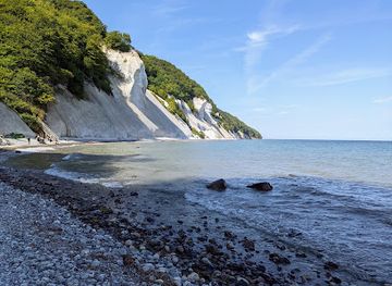
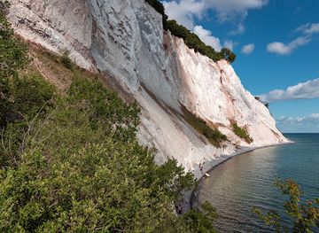
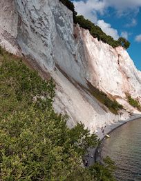
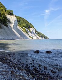
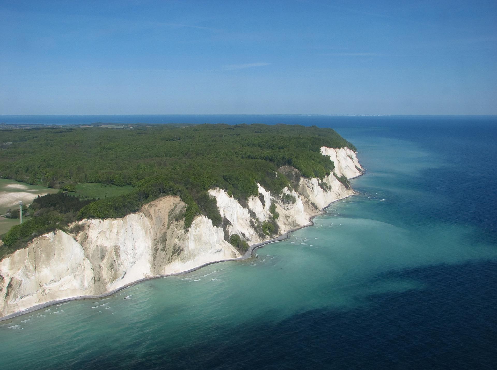
Denmark's tallest white chalk cliffs rise 128 meters above the Baltic, crowned by legendary tales and ancient forests.
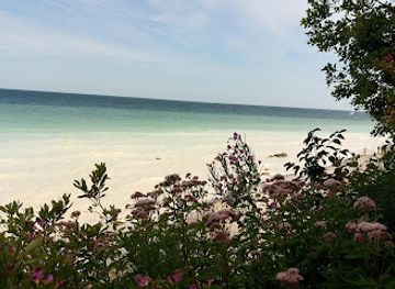
The Geological Masterpiece of Denmark's Highest Cliffs

Høje Møn stands as one of Europe's most remarkable geological formations, with chalk cliffs stretching approximately 6 kilometers along Møn's eastern coastline and reaching heights of up to 128 meters above sea level. These dramatic white formations were created over 70 million years ago during the Cretaceous period, when countless shells and marine organisms accumulated on the seafloor. Layer upon layer of sediment compacted over millennia, eventually forming the iconic chalk structures visible today. During the last ice age, roughly 12,000 years ago, glacial pressure folded and squeezed these ancient chalk layers, creating the distinctive black flint stripes that stripe the cliffs like geological fingerprints. The visible flint bands serve as permanent records of the immense forces that shaped this landscape. The cliffs continue to evolve through natural processes. Landslides, both large and small, have occurred over centuries, gradually reshaping the cliff face and creating the dramatic topography visitors encounter today. Notable collapses, such as Freuchen's Headland in 1998, demonstrate that Høje Møn remains an active, dynamic landscape where geological forces continue their ancient work.

Legendary Landscapes and Mythical Narratives

Beyond its scientific significance, Høje Møn is steeped in Danish folklore and legend. The area is said to be the Kingdom of the Cliff King, a mythical realm where the Cliff King resides in a great hall deep within the cliffs. According to local tales, visitors might encounter the Cliff King on horseback in the depressions south of Kongsbjerg, particularly in Kongens Køkken and Slumrehule. The highest point in the region, Aborrebjerg at 143 meters, offers panoramic views across the Baltic Sea, and on clear days, visibility extends northward to Stevns and westward to the Farø Islands and Møn Bridge. The landscape's dramatic topography—with its steep hills, rounded valleys, and mysterious forest terrain—creates an atmosphere that naturally invites such legendary interpretations.

Biodiversity and Natural Habitats

Høje Møn supports exceptional biodiversity within its varied ecosystems. The chalk-rich soils create unique conditions for rare plant species, particularly at Høvblege, a chalky hilltop where nine species of wild orchids flourish alongside numerous other rare plants. The high lime content in the soil makes the terrain unsuitable for cultivation, preserving it as open pasture for over a century and creating ideal conditions for specialized flora. The large blue butterfly, a species found nowhere else in Denmark, inhabits these sun-drenched southern slopes. The surrounding beech forests, known as Klinteskoven, transition from deciduous to coniferous woodland and harbor rich opportunities for observing both flora and bird life. Migratory birds are particularly abundant, making Høje Møn a significant ornithological destination. The entire region was designated as Denmark's first UNESCO Biosphere Reserve in June 2017, encompassing approximately 45,118 hectares across multiple islands and islets in the southern Baltic Sea.

Archaeological Treasures and Ancient Monuments

The landscape of Høje Møn is dotted with Bronze Age and Iron Age burial mounds, with over 100 documented in the area between Klintholm Gods and Havrelukke. Medieval traces remain visible in the form of high-backed fields—undulating lines in the forest floor created by the heavy wheel ploughs of medieval farmers. The region also contains Neolithic passage graves and round barrows dating back thousands of years, including the restored Klekkende Høj, a double passage grave approximately 4,500 years old. These archaeological features weave together a narrative spanning millennia, from prehistoric burial practices through medieval land use, creating a palimpsest of human presence within this dramatic natural setting.

Exploration and Access Routes

The primary access point is the GeoCenter Møns Klint, a geological museum that opened in 2007 and serves as the gateway to the cliffs. From the parking area nestled within the beech forest, visitors descend via a flight of 500 steps to reach the narrow beach below. The most spectacular viewpoint, Dronningestolen (the Queen's Chair), marks the highest point of the cliff face with an almost vertical 128-meter drop. Multiple hiking routes traverse the area, including the 14-kilometer Kingdom of the Cliff King trail, which requires at least 6 hours to complete and demands moderate to good physical fitness due to elevation changes and numerous steps. The trail encompasses the best natural and cultural sights, passing through the mythical cliff forest, visiting ancient monuments, and including the romantic Liselund Castle gardens before returning to Møns Klint via a scenic back road. Alternative routes allow visitors to climb the steps at Røde Udfald and return along the beach, or to explore southward from the GeoCenter past the remains of Freuchen's Headland.

Visitor Experience and Seasonal Considerations

Høje Møn attracts thousands of visitors annually, drawn by its combination of geological wonder, natural beauty, and cultural heritage. The area is best visited between May and September, when weather conditions are most favorable and the landscape displays its full seasonal richness. The beech forests provide cooling shade during warmer months, while the open chalk hills offer expansive views. The varied terrain accommodates different activity levels, from leisurely forest walks to challenging multi-hour hikes. The GeoCenter provides educational context through exhibits tracing Denmark's geological origins and the formation of the cliffs, enriching the visitor experience with scientific understanding. Nearby attractions include Liselund, an 18th-century Romantic palace with fairytale gardens, and Klintholm Castle Park, which historically encompassed Møns Klint until its sale to the state in 1980 for preservation purposes.

Local tips

  • Wear sturdy hiking boots with good grip—the chalk can be slippery, especially after rain, and the 500-step descent to the beach is steep. The terrain is uneven throughout the forest trails.
  • Visit the GeoCenter Møns Klint first to understand the geological history and get oriented. The museum provides essential context that enriches your exploration of the cliffs and surrounding landscape.
  • Allow extra time for the Kingdom of the Cliff King trail—the 14-kilometer route takes at least 6 hours and involves significant elevation changes. Start early to complete it comfortably before daylight fades.
  • Visit Høvblege in late spring or early summer to see the nine species of wild orchids in bloom. The chalky hilltop also offers exceptional views of the Baltic Sea and is home to Denmark's only large blue butterfly population.
  • Bring binoculars for birdwatching, particularly during migration seasons. The beech forests and open landscapes support diverse bird species, making Høje Møn a rewarding destination for ornithologists.
widget icon

Buy tickets

    No tickets available

Book tours with entry

    No tours available

Book tours without entry

    No tours available

A brief summary to Høje Møn

  • Borre, DK

Getting There

  • By Car from Copenhagen

    Drive south via the E47/E55 motorway toward southern Zealand, then cross Dronning Alexandrines Bro to reach Møn island. The journey to Møns Klint takes approximately 2 hours from Copenhagen. Follow well-marked signs once on Møn. A paid parking lot is located directly at the GeoCenter Møns Klint facility adjacent to the cliffs. This is the most convenient option for accessing Høje Møn.

  • By Train and Bus from Copenhagen

    Take a train from Copenhagen to Vordingborg (approximately 1 hour), then transfer to a bus service bound for Møns Klint. The combined journey takes roughly 3 hours total. Bus services operate regularly during peak season (May–September) but may be less frequent in winter months. Check local schedules in advance, as service frequency varies seasonally.

  • By Bicycle from Copenhagen

    Denmark's extensive cycling network offers scenic routes from Copenhagen to Møn, passing through picturesque countryside. The journey covers approximately 130 kilometers and takes 6–8 hours depending on route and fitness level. This option suits active travelers seeking an immersive experience of the Danish landscape. Bike rental is available in Copenhagen and throughout the region.

  • Local Transport on Møn

    Once on Møn, local buses connect the main town of Stege to Møns Klint and surrounding attractions. Stege is located approximately 1 hour and 20 minutes from Copenhagen by car. From Stege, Møns Klint is accessible via local bus service or a 20-minute drive. Taxis and ride-sharing services operate on the island but are less frequent than in urban areas.

Popular Experiences near Høje Møn

Popular Hotels near Høje Møn

Select Currency