

Mount Longonot Travel Guide - Free Web & App
Your ultimate guide to Mount Longonot. Discover top landmarks, proposed trips, and local tips. Free on the web or via the Evendo companion app.


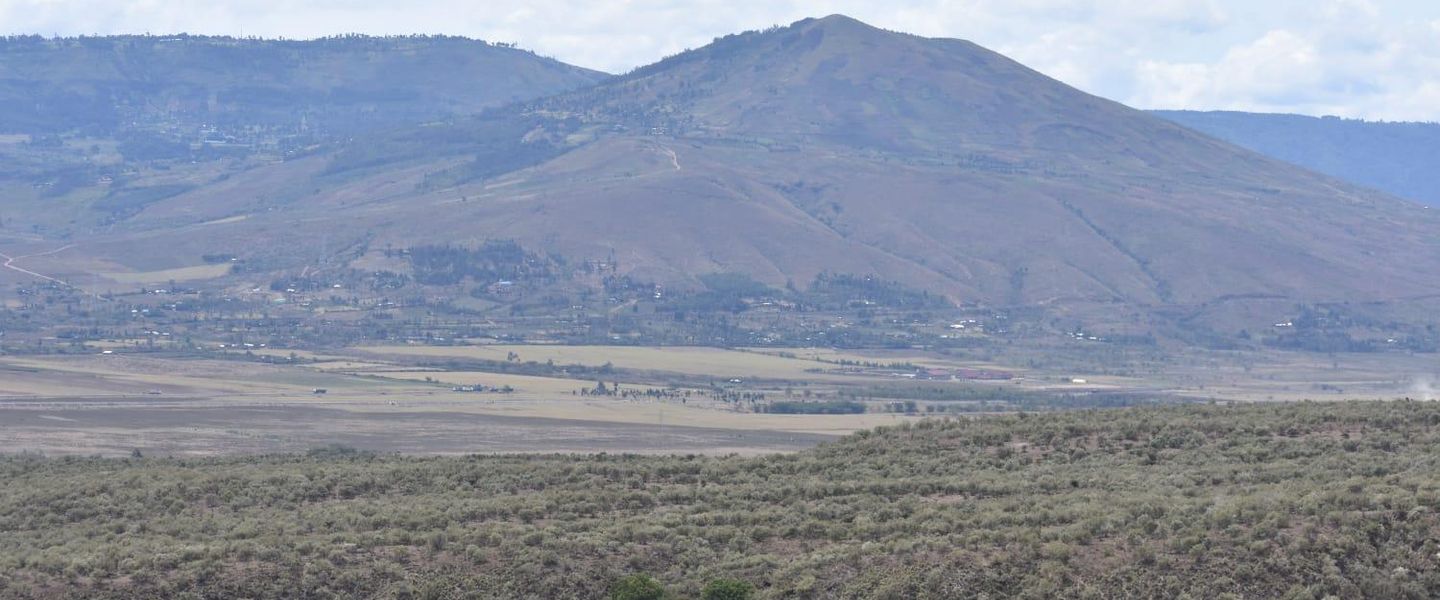


Mount Longonot, Kenya: hike a dormant volcano near Lake Naivasha, walk the crater rim, see Rift Valley scenery and explore wildlife-rich slopes.
A Volcanic Landmark Above the Rift Valley
Mount Longonot rises from Kenya’s Great Rift Valley south-east of Lake Naivasha, its broad volcanic cone standing apart from the surrounding plains. Reaching about 2,776 metres above sea level, it is the central feature of Mount Longonot National Park, a compact protected area visited primarily for its demanding hike and expansive views. The mountain’s profile is particularly distinctive because the summit encloses a wide crater, while deep radial gullies cut down the outer slopes.Read more about Mount Longonot
The Climb and Crater Rim
Wildlife and the Wider Landscape
When is the best time to visit Mount Longonot?
Best: December–February · 20°C| Month | High (°C) | Rainfall (mm) |
|---|---|---|
| January (best) | 20 | 46 |
| February (best) | 20 | 61 |
| March | 20 | 79 |
| April | 19 | 101 |
| May | 18 | 126 |
| June | 17 | 139 |
| July | 16 | 135 |
| August | 16 | 121 |
| September | 18 | 98 |
| October | 19 | 78 |
| November | 19 | 60 |
| December (best) | 20 | 48 |
Getting to and around Mount Longonot
How to get there
Best attractions in Mount Longonot
The principal attraction is the mountain itself: a steep volcanic cone whose trail climbs from the park gate to the crater rim and then continues around the uneven edge for broad views over the Great Rift Valley. The crater interior, partly covered by forest, provides a dramatic contrast with the open, dry slopes outside it, while the radial gullies give the outer mountain its characteristic spurred appearance. Lower sections of Mount Longonot National Park contain grassland and shrubland where visitors may encounter zebra, giraffe, eland, buffalo and birdlife, though wildlife sightings are unpredictable. The summit route is the park’s defining experience rather than one attraction among many. Naivasha and Lake Naivasha lie nearby and provide hospitality and additional excursions, while Hell’s Gate National Park is a separate neighbouring destination, not part of Mount Longonot National Park.
-
Tourist attraction
Mawingu Camp Kenya
Discover the natural beauty and cultural richness of Mawingu Camp, a serene retreat in Kenya's breathtaking Rift Valley region.
-
Hiking area
Kilele Ngamia - Longot Summit
Discover the breathtaking beauty and adventure of Kilele Ngamia - Longot Summit, a premier hiking destination in Kenya's stunning landscapes.
-
 Garden
Salvon Africa
Explore the tranquil beauty of Salvon Africa, a stunning garden oasis in Longonot, perfect for relaxation and nature appreciation.
-
Garden
Kelvin one
Discover the enchanting Kelvin One garden in Naivasha, a peaceful retreat brimming with vibrant flora and serene landscapes perfect for relaxation.


Best landmarks in Mount Longonot
Mount Longonot’s crater is its defining natural landmark, a broad volcanic depression enclosed by a rim from which the Great Rift Valley unfolds in several directions. The crater forest creates a dark central contrast against the drier, sparsely shaded exterior slopes, while the deeply eroded radial gullies explain the Maasai-derived name Oloonong’ot, “mountain of many spurs”. The mountain’s isolated cone is itself a major Rift Valley landmark, visible from surrounding roads and plains. Its significance is geological as a volcanic formation, ecological as protected habitat and cultural as a named feature in the landscape of Maasai country. Lake Naivasha and the escarpments beyond form important views from higher ground, but they are separate regional landmarks rather than features contained within Mount Longonot National Park.
-
National park
Mount Longonot National Park
Discover the breathtaking landscapes and thrilling hiking trails at Mount Longonot National Park, a premier destination for nature lovers in Kenya.
-
Hiking area
Mt Longonot National Park
Discover the breathtaking beauty and adventure of Mt Longonot National Park, a top hiking destination in Kenya's Great Rift Valley.
-
Hiking area
Longonot Volcano crater
Discover the breathtaking beauty of Longonot Volcano Crater, a premier hiking destination in Kenya offering stunning views and unforgettable experiences.
-
Hiking area
Mt Longonot hiking trail
Discover the stunning beauty and adventure of Mt Longonot Hiking Trail in the Great Rift Valley, perfect for nature lovers and outdoor enthusiasts.


Explore Mount Longonot on the map
Plan your trip on one map. See where the top attractions, landmarks, restaurants and hotels are, and book hotels and experiences in a few clicks.
Best hotels in Mount Longonot
Best restaurants in Mount Longonot
Mount Longonot itself has limited dining infrastructure, so visitors normally eat before or after the hike or carry suitable provisions in accordance with park rules. Naivasha is the main nearby centre for restaurants, cafés, hotels and informal food outlets, with choices shaped by Kenyan home cooking, East African staples and the needs of travellers exploring the Rift Valley. Meals may include dishes based on ugali, rice, beans, vegetables, nyama choma and other grilled meats, while larger tourism establishments may also offer international menus. The farming and fishing economy around the wider Naivasha area influences local food supply, although visitors should not assume that every lakeside venue serves locally caught fish. For an early start, arrange breakfast and packed food through accommodation or a reputable local provider rather than relying on facilities at the park gate.
-
Restaurant
Weekend Inn Restaurant
Experience authentic Kenyan cuisine at Weekend Inn Restaurant in Longonot – where every meal is a celebration of local flavors.

Best bars in Mount Longonot
Evening life is quiet around Mount Longonot because the national park is a daytime hiking and wildlife destination rather than a nightlife centre. Visitors generally spend the evening at accommodation in Naivasha, where hotel bars, restaurants and informal local venues provide space for a drink or meal, with the atmosphere varying by establishment and day of the week. Traditional pubs and social venues are more relevant to the town than to the protected mountain, and there is no reason to expect entertainment facilities on the crater or lower trail. Naivasha may also host occasional cultural or community events, but these are not continuous attractions and should be checked locally. For wildlife-focused or early-morning itineraries, evenings are usually best used for rest, route planning and preparing for changing mountain conditions.
-
Grill
Kindaruma Bar & Restaurant
Discover the vibrant flavors of Kenya at Kindaruma Bar & Restaurant, where grilled delights and local hospitality come together.
-
Bar
The Weekend Inn Bar
Unwind at The Weekend Inn Bar in Longonot, where vibrant atmosphere meets refreshing drinks and local camaraderie.
-
Bar
Double M Bar
Experience the lively charm of Double M Bar in Longonot, where refreshing drinks and friendly vibes await every traveler.
-
Bar
Leenas Pub
Discover the lively ambiance of Leenas Pub in Longonot, a hotspot for socializing and enjoying refreshing drinks in a friendly atmosphere.


Best nightclubs in Mount Longonot
Evening life is quiet around Mount Longonot because the national park is a daytime hiking and wildlife destination rather than a nightlife centre. Visitors generally spend the evening at accommodation in Naivasha, where hotel bars, restaurants and informal local venues provide space for a drink or meal, with the atmosphere varying by establishment and day of the week. Traditional pubs and social venues are more relevant to the town than to the protected mountain, and there is no reason to expect entertainment facilities on the crater or lower trail. Naivasha may also host occasional cultural or community events, but these are not continuous attractions and should be checked locally. For wildlife-focused or early-morning itineraries, evenings are usually best used for rest, route planning and preparing for changing mountain conditions.
-
Bar
The Weekend Inn Bar
Discover the charm of The Weekend Inn Bar in Longonot, where relaxation meets local culture in a cozy atmosphere.

Best shops in Mount Longonot
Shopping opportunities are concentrated in Naivasha rather than inside Mount Longonot National Park. The town is the practical place to obtain water, snacks, outdoor essentials and everyday supplies before a hike, while selected shops and craft sellers may offer Kenyan textiles, beadwork, carvings, artwork and souvenirs. Visitors should distinguish genuinely locally made goods from mass-produced items and ask respectfully about materials and provenance. Agricultural products from the wider Rift Valley are also visible in local markets and food businesses, although individual stalls and stock change regularly. The park entrance is not a shopping district, and visitors should not expect a range of boutiques, permanent craft markets or specialist equipment retailers beside the trail. Nairobi provides a broader choice of Kenyan crafts and outdoor equipment for travellers passing through the capital.
-
National park
Mount Longonot National Park
Explore the breathtaking scenery and wildlife of Mount Longonot National Park, a stunning national park in the heart of Kenya's Great Rift Valley.
-
Hiking area
Mt Longonot National Park
Discover the breathtaking landscapes and wildlife of Mt Longonot National Park, a premier hiking destination in the heart of Kenya's Great Rift Valley.
-
Shopping mall
Longonot
Experience the best of shopping and dining at Longonot, a vibrant mall with diverse stores and eateries perfect for tourists seeking excitement.
-
Wine store
Dreams Wines & Spirits
Discover a world of exquisite wines and spirits at Dreams Wines & Spirits, your go-to destination for beverage exploration and enjoyment.


Get your free copy of our complete guide to Mount Longonot, delivered straight to you.
Everything on this page, from attractions and restaurants to essentials and local phrases, in one PDF you can read offline, print or share.
Already have an account? Sign in
Your Mount Longonot guide is ready.
We'll send it to · Not you? Sign out

Getting your guide ready…
We are putting together a fresh copy of the Mount Longonot guide. This can take up to a minute.
This can take a few moments. If your browser asks, choose Allow so the download can start. You'll find the guide in your Downloads folder.
Nothing happened? Download it again
Sorry, the guide is taking longer than usual. Please try again in a minute, or get it by email instead.
From Eve
Local phrases worth knowing
You don't need to get them perfect. A few words go a long way, and locals appreciate the effort.
Basics
| English | Local | Say it |
|---|---|---|
| Hello | Salamu | [sa-la-mu] |
| Goodbye | Kwaheri | [kwa-he-ri] |
| Yes | Ndiyo | [n-di-yo] |
| No | Hapana | [ha-pa-na] |
| Please/You're welcome | Tafadhali | [ta-fa-dha-li] |
| Thank you | Asante | [a-san-te] |
| Excuse me/Sorry | Samahani | [sa-ma-ha-ni] |
| How are you? | Uko aje? | [u-ko a-je] |
| Fine. And you? | Poa. Na wewe? | [po-a. na we-we] |
| Do you speak English? | Unazungumza Kiingereza? | [u-na-zun-gum-za ki-in-ge-re-za] |
| I don't understand | Sieelewi | [si-e-le-wi] |
Eating & Drinking
| English | Local | Say it |
|---|---|---|
| I'd like to see the menu, please | Ningependa kuona menyu, tafadhali | [nin-ge-pen-da ku-o-na me-nyu, ta-fa-dha-li] |
| I don't eat meat | Si kula nyama | [si ku-la nya-ma] |
| Cheers! | Mambo! | [mam-bo] |
| I would like to pay, please | Ningependa kulipa, tafadhali | [nin-ge-pen-da ku-li-pa, ta-fa-dha-li] |
Emergencies
| English | Local | Say it |
|---|---|---|
| Help! | Msaada! | [m-sa-a-da] |
| Go away! | Nenda zako! | [nen-da za-ko] |
| Call the Police! | Piga simu polisi! | [pi-ga si-mu po-li-si] |
| Call a doctor! | Piga simu daktari! | [pi-ga si-mu dak-ta-ri] |
| I'm lost | Nimepotea | [ni-me-po-te-a] |
| I'm ill | Ninaumwa | [ni-na-um-wa] |
Shopping
| English | Local | Say it |
|---|---|---|
| I'd like to buy... | Ningependa kununua... | [nin-ge-pen-da ku-nu-nu-a] |
| I'm just looking | Ninaangalia tu | [ni-na-an-ga-lia tu] |
| How much is it? | Ni bei gani? | [ni bei ga-ni] |
| That's too expensive | Hiyo ni ghali sana | [hi-yo ni gha-li sa-na] |
| Can you lower the price? | Unaweza kupunguza bei? | [u-na-we-za ku-pun-gu-za bei] |
Time & Numbers
| English | Local | Say it |
|---|---|---|
| What time is it? | Saa ngapi? | [sa-a nga-pi] |
| It's one o'clock | Saa moja | [sa-a mo-ja] |
| Half past (10) | Nusu saa kumi | [nu-su sa-a ku-mi] |
| Morning | Asubuhi | [a-su-bu-hi] |
| Afternoon | Mchana | [m-cha-na] |
| Evening | Jioni | [jo-ni] |
| Yesterday | Jana | [ja-na] |
| Today | Leo | [le-o] |
| Tomorrow | Kesho | [ke-sho] |
| 1 | Moja | [mo-ja] |
| 2 | Mbili | [m-bi-li] |
| 3 | Tatu | [ta-tu] |
| 4 | Nne | [n-ne] |
| 5 | Tano | [ta-no] |
| 6 | Sita | [si-ta] |
| 7 | Saba | [sa-ba] |
| 8 | Nane | [na-ne] |
| 9 | Tisa | [ti-sa] |
| 10 | Kumi | [ku-mi] |
Transport & Directions
| English | Local | Say it |
|---|---|---|
| Where's a/the...? | Iko wapi...? | [i-ko wa-pi] |
| What's the address? | Anwani ni gani? | [an-wa-ni ni ga-ni] |
| Can you show me (on the map)? | Unaweza kunionyesha (kwenye ramani)? | [u-na-we-za ku-ni-o-nye-sha (kwe-nye ra-ma-ni)] |
| When's the next (bus)? | Basi lifuatalo ni saa ngapi? | [ba-si li-fua-ta-lo ni sa-a nga-pi] |
| A ticket (to ....) | Tiketi (kwenda ...) | [ti-ke-ti (kwen-da)] |
History of Mount Longonot
Formation of a Rift Valley Volcano
Mount Longonot was formed by volcanic activity associated with the spreading and faulting of the East African Rift. Its broad cone, summit crater and radiating gullies are products of volcanic construction followed by erosion. The mountain is generally described as dormant rather than extinct, although visitors should follow official park guidance and avoid treating its geological status as a guarantee of permanent inactivity. Its position beside the Rift Valley floor gives it a powerful geographical identity: a single volcanic massif rising above a landscape shaped by escarpments, lava and tectonic movement.
Maasai Name and Pastoral Landscape
The mountain is widely known by the Maasai name Oloonong’ot, usually translated as “mountain of many spurs”, a reference to the channels and ridges that descend from the crater rim. Long before it became a destination for hikers, the surrounding Rift Valley was part of a pastoral landscape used by Maasai communities and other neighbouring peoples. The name remains an important reminder that the mountain is not simply a geological object but part of a lived cultural geography, connected to routes, grazing country and local knowledge of the valley.
Exploration and Regional Development
Mount Longonot lies within a region transformed during the colonial period by new roads, railways, farms and administrative settlements around the Rift Valley. Naivasha developed as an important regional centre, while the wider valley attracted agricultural and conservation interests. These changes altered patterns of land use around the mountain, bringing the area increasingly into the orbit of organised travel and wildlife tourism. Longonot’s steep terrain and prominent outline helped distinguish it from the surrounding agricultural and pastoral plains as access through the region improved.
National Park Protection
Mount Longonot National Park was established to protect the volcano and its surrounding wildlife habitat, placing the mountain within Kenya’s wider network of protected landscapes. Park management has helped retain the upper slopes, crater and lower grasslands as a recognisable natural area despite development elsewhere in the Rift Valley. Today, the mountain’s principal historical importance lies in the relationship between geological heritage, local cultural identity, conservation and recreation: the same landscape is experienced as a spiritual and geographical reference point, wildlife habitat and challenging hiking destination.
Mount Longonot in Photos
Browse through our photo collection highlighting the charm and character of the destination.
Neighbouring destination travel guides
The closest destinations to Mount Longonot, if you have time for more than one.
-

-

-
-

-


Swipe for more destinations
Explore more

Explore more of Central Highlands
Explore Kenya’s Central Highlands for Mount Kenya treks, Aberdare forests, coffee farms, tea country, wildlife conservancies and cool upland scenery.
Explore Central Highlands
Explore more of Kenya
Discover Kenya: A land of breathtaking safaris, rich cultural heritage, and stunning coastlines that promise adventure and relaxation all in one.
Explore Kenya