

Khunjerab Pass Travel Guide - Free Web & App
Your ultimate guide to Khunjerab Pass. Discover top landmarks, proposed trips, and local tips. Free on the web or via the Evendo companion app.


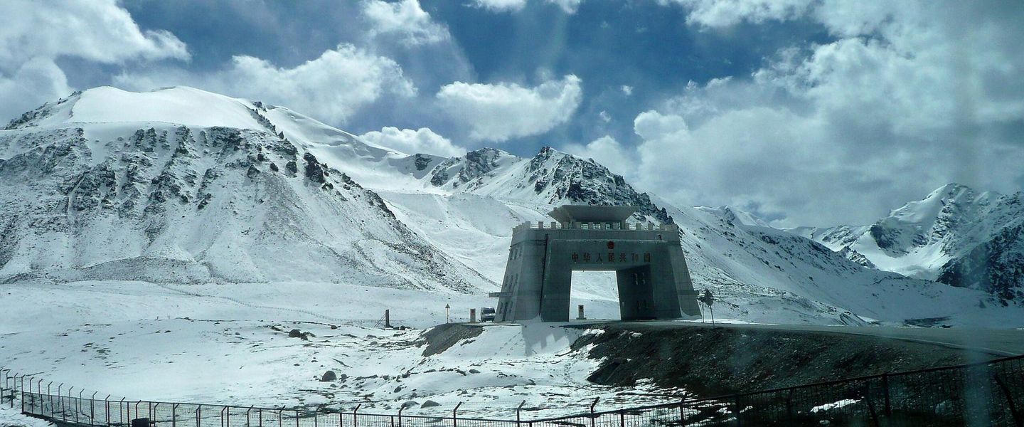


Khunjerab Pass in Pakistan reveals high-altitude Karakoram landscapes, the China border, national park wildlife and the historic Karakoram Highway beyond.
A High Mountain Borderland
Khunjerab Pass is Pakistan’s highest international border crossing, rising to approximately 4,693 metres in the Karakoram Mountains of Gilgit-Baltistan. It lies at the northern end of the Karakoram Highway, where Pakistan meets China’s Xinjiang region, and forms the dramatic culmination of one of Asia’s great road journeys. The pass itself is an austere landscape of broad alpine plateaux, steep brown and grey mountains, snowfields and glacial valleys, with the Khunjerab River draining through the high country towards the Hunza Valley.Read more about Khunjerab Pass
Khunjerab National Park
The Journey from Hunza
When is the best time to visit Khunjerab Pass?
Best: June–August · 23–26°C| Month | High (°C) | Rainfall (mm) |
|---|---|---|
| January | 1 | 5 |
| February | 2 | 6 |
| March | 7 | 8 |
| April | 11 | 12 |
| May | 18 | 20 |
| June (best) | 23 | 24 |
| July (best) | 26 | 28 |
| August (best) | 26 | 24 |
| September | 17 | 16 |
| October | 9 | 12 |
| November | 4 | 8 |
| December | 2 | 6 |
Getting to and around Khunjerab Pass
How to get there
Transportation
Best attractions in Khunjerab Pass
The defining attraction is the Khunjerab Pass itself, where the Karakoram Highway reaches a broad, stark saddle on the Pakistan-China frontier at approximately 4,693 metres. The approach through Khunjerab National Park reveals high plateaux, steep mountain walls, snowfields and the Khunjerab River, with occasional opportunities to look for Marco Polo sheep, ibex and other high-altitude wildlife. The road journey is part of the experience, particularly the transition from the cultivated villages and dramatic gorges of upper Hunza into the open, treeless border landscape. Sost, the nearest Pakistani settlement, serves as the practical gateway for supplies and access arrangements rather than as an attraction of the pass itself. Farther south, Passu, Gulmit and other Hunza communities provide cultural and scenic stops along the route, but they lie outside the immediate pass area. Visitors should distinguish the controlled border site from the wider national park and confirm where stopping, photography and walking are permitted.
-
Tourist attraction
Baltit Fort Hunza
Experience the rich history and breathtaking views at Baltit Fort, a stunning cultural landmark in the heart of Hunza Valley.
-
Rakaposhi View Point Hotel & Restaurant
Experience stunning mountain views and authentic local cuisine at Rakaposhi View Point Hotel & Restaurant in Ghulmet, Pakistan.
-
Ravine
Hunza Valley
Explore Hunza Valley, a breathtaking ravine in Pakistan’s Gilgit-Baltistan, renowned for its stunning landscapes, rich culture, and warm hospitality.
-
Tourist attraction
Altit Fort
Discover the historical Altit Fort in Hunza Valley, a stunning landmark rich in culture and breathtaking views, perfect for every traveler.


Best landmarks in Khunjerab Pass
Khunjerab Pass is the principal landmark, a high natural saddle marking Pakistan’s northern frontier and the final ascent of the Karakoram Highway. Its significance is geographical and political as well as scenic: the road, border infrastructure and surrounding plateaux demonstrate how an international route crosses one of the world’s most demanding mountain systems. Khunjerab National Park forms the wider natural setting, protecting high-altitude valleys and slopes associated with Marco Polo sheep, ibex and snow leopard habitat. The Khunjerab River provides a defining physical thread through the landscape, while the bare mountain walls and snow-covered ridges emphasise the pass’s elevation. The highway itself is a modern engineering landmark, linking the upper Hunza region with China through a corridor once crossed only by arduous mountain travel. Sost, south of the pass, is the nearest important settlement and gateway, but it is distinct from the border landmark and the open park landscape beyond it.
-
Park
Khunjarab National Park Entry Point
Explore the breathtaking beauty of Khunjarab National Park, where towering peaks and diverse wildlife await at the highest national park in Pakistan.

Explore Khunjerab Pass on the map
Plan your trip on one map. See where the top attractions, landmarks, restaurants and hotels are, and book hotels and experiences in a few clicks.
Best hotels in Khunjerab Pass
Best restaurants in Khunjerab Pass
Khunjerab Pass has no established dining scene, and travellers should carry provisions for the high-altitude road. The most practical meals are found before departure in Hunza’s settlements and in Sost, where local eateries and simple cafés serve regional food according to seasonal availability. Hunza cuisine reflects its mountain environment, with apricots, walnuts, mulberries, wheat, potatoes and other locally grown produce appearing in household and village cooking. In the wider valley, visitors may encounter dishes such as chapshoro, a filled pastry associated with Hunza and neighbouring areas, as well as breads, soups, noodles and simple rice-based meals. Sost and the larger Hunza settlements also provide some Chinese-influenced food because of the highway’s cross-border connections, but choice is limited compared with Pakistan’s cities. Food availability beyond Sost is sparse, so meals, snacks and drinking water should be arranged before heading towards the pass.
-
Restaurant
Khunjerav Cafe'
Discover delicious local cuisine amidst stunning mountain views at Khunjerav Cafe', your perfect pit stop in Gilgit-Baltistan.
-
Restaurant
Khunjarab Wild Garden Restaurant & Camping Site Toqroqeen
Experience authentic Pakistani cuisine in a serene setting at Khunjarab Wild Garden Restaurant & Camping Site in Hunza Nagar.


Best shops in Khunjerab Pass
Shopping at Khunjerab Pass is limited to practical purchases and occasional border-area trading activity rather than a developed retail scene. Sost is the nearest Pakistani settlement for basic supplies, while more varied shopping is available farther south in Hunza’s towns and villages. Visitors may find dried apricots, walnuts, mulberries, local honey and other products associated with Hunza’s irrigated mountain agriculture, alongside handicrafts and textiles sold in the wider valley. Traditional woollen goods, caps, carved items and small artworks may be available from local producers, although stock varies and should not be treated as guaranteed. Karimabad and other established Hunza settlements offer more opportunities to purchase regional food products and craft items than the pass corridor. Travellers should buy fuel, snacks, water and essential medicines before heading north, because retail facilities become increasingly scarce beyond Sost and there are no conventional shopping streets at the border.
-
Jewelry store
The Mountain Shop
Explore The Mountain Shop in Gojal for exquisite jewelry that reflects the rich cultural heritage of the Karakoram region.
-
Souvenir store
Hunza Souvenir
Discover authentic handcrafted treasures at Hunza Souvenir, where local artistry meets the stunning beauty of the Hunza Valley.


Get your free copy of our complete guide to Khunjerab Pass, delivered straight to you.
Everything on this page, from attractions and restaurants to essentials and local phrases, in one PDF you can read offline, print or share.
Already have an account? Sign in
Your Khunjerab Pass guide is ready.
We'll send it to · Not you? Sign out

Getting your guide ready…
We are putting together a fresh copy of the Khunjerab Pass guide. This can take up to a minute.
This can take a few moments. If your browser asks, choose Allow so the download can start. You'll find the guide in your Downloads folder.
Nothing happened? Download it again
Sorry, the guide is taking longer than usual. Please try again in a minute, or get it by email instead.
Khunjerab Pass essentials
Currency and Payment
Safety
Emergency Situations
Do's and Don'ts
Local Tips
From Eve
Local phrases worth knowing
You don't need to get them perfect. A few words go a long way, and locals appreciate the effort.
Basics
| English | Local | Say it |
|---|---|---|
| Hello | سلام | [salaam] |
| Goodbye | خدا حافظ | [khuda hafiz] |
| Yes | ہاں | [haan] |
| No | نہیں | [nahin] |
| Please/You're welcome | براہ کرم | [barah-e-karam] |
| Thank you | شکریہ | [shukriya] |
| Excuse me/Sorry | معذرت چاہتا ہوں | [maazrat chahta hoon] |
| How are you? | آپ کیسے ہیں؟ | [aap kaise hain?] |
| Fine. And you? | ٹھیک ہوں۔ اور آپ؟ | [theek hoon. aur aap?] |
| Do you speak English? | کیا آپ انگریزی بولتے ہیں؟ | [kya aap angrezi boltay hain?] |
| I don't understand | مجھے سمجھ نہیں آیا | [mujhe samajh nahi aya] |
Eating & Drinking
| English | Local | Say it |
|---|---|---|
| I'd like to see the menu, please | براہ کرم مینو دیکھنا ہے | [barah-e-karam menu dekhna hai] |
| I don't eat meat | میں گوشت نہیں کھاتا | [main gosht nahi khata] |
| Cheers! | خوش رہئیں! | [khush rahiye] |
| I would like to pay, please | براہ کرم ادا کرنا ہے | [barah-e-karam ada karna hai] |
Emergencies
| English | Local | Say it |
|---|---|---|
| Help! | مدد! | [madad!] |
| Go away! | دور ہوجاؤ! | [door ho jao!] |
| Call the Police! | پولیس کو بلاؤ! | [police ko bulao!] |
| Call a doctor! | ڈاکٹر کو بلاؤ! | [doctor ko bulao!] |
| I'm lost | میں گم ہوگیا ہوں | [main gum ho gaya hoon] |
| I'm ill | میں بیمار ہوں | [main bemar hoon] |
Shopping
| English | Local | Say it |
|---|---|---|
| I'd like to buy... | میں خریدنا چاہتا ہوں... | [main kharidna chahta hoon...] |
| I'm just looking | میں صرف دیکھ رہا ہوں | [main sirf dekh raha hoon] |
| How much is it? | یہ کتنا ہے؟ | [ye kitna hai?] |
| That's too expensive | یہ بہت مہنگا ہے | [ye bohot mehnga hai] |
| Can you lower the price? | کیا آپ قیمت کم کرسکتے ہیں؟ | [kya aap qeemat kam kar sakte hain?] |
Time & Numbers
| English | Local | Say it |
|---|---|---|
| What time is it? | وقت کیا ہوا ہے؟ | [waqt kya hua hai?] |
| It's one o'clock | ایک بجے ہیں | [aik bajay hain] |
| Half past (10) | دس بج کر پندرہ منٹ ہوچکے ہیں | [das baj kar pandrah minute hochuke hain] |
| Morning | صبح | [subah] |
| Afternoon | دوپہر | [dopehar] |
| Evening | شام | [shaam] |
| Yesterday | گزشتہ دن | [guzishta din] |
| Today | آج | [aaj] |
| Tomorrow | کل | [kal] |
| 1 | ایک | [aik] |
| 2 | دو | [do] |
| 3 | تین | [teen] |
| 4 | چار | [chaar] |
| 5 | پانچ | [paanch] |
| 6 | چھے | [chhe] |
| 7 | سات | [saat] |
| 8 | آٹھ | [aath] |
| 9 | نو | [no] |
| 10 | دس | [das] |
Transport & Directions
| English | Local | Say it |
|---|---|---|
| Where's a/the...? | ...کہاں ہے؟ | [kahan hai?] |
| What's the address? | پتہ کیا ہے؟ | [pata kya hai?] |
| Can you show me (on the map)? | کیا آپ مجھے (نقشے پر) دکھا سکتے ہیں؟ | [kya aap mujhe (naqsha par) dikhha sakte hain?] |
| When's the next (bus)? | اگلی (بس) کب ہے؟ | [agli (bus) kab hai?] |
| A ticket (to ....) | ایک ٹکٹ (سے .... تک) | [aik ticket (se .... tak)] |
History of Khunjerab Pass
An Ancient High-Mountain Route
The Khunjerab corridor belongs to a wider network of movement through the Karakoram that linked communities in the upper Hunza region with routes towards Central Asia and the Tarim Basin. The high pass was not an urban centre or a continuously settled trade town; its severe climate limited permanent habitation. Instead, its importance lay in the possibility of crossing a formidable mountain frontier through seasonal travel, pastoral movement and long-distance exchange. The wider Hunza area developed distinctive languages, customs and settlement patterns shaped by its position between South and Central Asian cultural worlds.
Hunza and the Northern Frontier
For centuries, the Hunza Valley was governed by the hereditary rulers known as the Mirs of Hunza, whose territory extended through a difficult landscape of valleys, side valleys and mountain passes. Local communities combined irrigated agriculture in the lower valleys with pastoral practices suited to high elevations. Political authority, trade and relations with neighbouring valleys were shaped by the terrain, while the northern routes connected Hunza to wider regional networks. Khunjerab’s modern significance developed from this older frontier history rather than from a large settlement at the pass itself.
The Karakoram Highway
The modern road transformed the Khunjerab corridor. Constructed through Pakistan and China from the 1960s and opened for regular public use in the late 1970s, the Karakoram Highway links the plains of Pakistan with Gilgit-Baltistan and Xinjiang. Its construction was a major engineering undertaking across one of the world’s highest mountain systems, involving steep valleys, unstable slopes and severe weather. At Khunjerab Pass, the highway became both an international transport route and a powerful symbol of cooperation between Pakistan and China.
National Park and Conservation
Khunjerab National Park was established in 1975 to conserve the high-altitude ecosystems and wildlife of the border region. Its broad valleys and mountain slopes provide habitat for species such as Marco Polo sheep, Himalayan ibex, blue sheep and snow leopards, although the remoteness and scale of the park make encounters uncertain. Conservation has had to coexist with transport, border administration and the needs of communities in the wider Hunza region. Today, the pass is understood both as a controlled international frontier and as part of a protected mountain landscape.
Khunjerab Pass in Photos
Browse through our photo collection highlighting the charm and character of the destination.
Neighbouring destination travel guides
The closest destinations to Khunjerab Pass, if you have time for more than one.
-

-

-

-
-


Swipe for more destinations
Explore more

Explore more of Hunza Valley
Explore Hunza Valley in Pakistan for Karakoram views, historic forts, orchard villages, Attabad Lake and high mountain journeys.
Explore Hunza Valley
Explore more of Pakistan
Discover Pakistan: A land of majestic mountains, rich history, and delicious cuisine, where every journey is an adventure and every moment is filled with wonder.
Explore Pakistan