

Badlands National Park Travel Guide - Free Web & App
Your ultimate guide to Badlands National Park. Discover top landmarks, proposed trips, and local tips. Free on the web or via the Evendo companion app.


Badlands National Park in South Dakota reveals striped cliffs, fossil beds, prairie wildlife, scenic drives and Lakota heritage in a deeply eroded landscape.
A Landscape of Contrasts
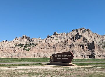
Badlands National Park occupies roughly 244,000 acres in south-western South Dakota, where sharply eroded ridges, pinnacles and gullies rise abruptly from the surrounding mixed-grass prairie. Its banded formations appear in shades of cream, yellow, red and grey, shaped by wind and water from layers of sediment deposited over geological time. The scenery changes constantly along Badlands Loop Road, from broad prairie horizons to narrow overlooks above deeply cut ravines. The park is divided by the main North Unit, the more remote Stronghold Unit and the Palmer Creek Unit, so a visit can range from a short scenic stop to several days of exploration.Read more about Badlands National Park
Fossils, Wildlife and Lakota Heritage
Ways to Experience the Park
When is the best time to visit Badlands National Park?
Best: May, August–September · 24–31°C| Month | High (°C) | Rainfall (mm) |
|---|---|---|
| January | 0 | 8 |
| February | 2 | 9 |
| March | 9 | 16 |
| April | 17 | 24 |
| May (best) | 24 | 43 |
| June | 30 | 53 |
| July | 33 | 42 |
| August (best) | 31 | 35 |
| September (best) | 25 | 30 |
| October | 18 | 25 |
| November | 7 | 15 |
| December | 1 | 8 |
Getting to and around Badlands National Park
How to get there
Transportation
Best attractions in Badlands National Park
Badlands Loop Road is the principal scenic route through the North Unit, linking viewpoints such as Big Badlands Overlook, Yellow Mounds Overlook and Pinnacles Overlook with trailheads and prairie vistas. Door, Window and Notch trails provide close views of the eroded formations, while Castle Trail offers a longer walk through the park's changing terrain. The Fossil Exhibit Trail interprets the ancient mammals preserved in the White River sediments, and the Ben Reifel Visitor Center provides displays and ranger information. Sage Creek Rim Road leads towards quieter grassland and Roberts Prairie Dog Town, where prairie dogs create one of the park's most characteristic wildlife scenes. Bison, bighorn sheep, pronghorn, coyotes and birds may be seen across the prairie, although sightings are never guaranteed. The Stronghold District offers a more remote landscape and important Lakota associations, while the nearby Minuteman Missile National Historic Site, outside the park, provides a separate perspective on the region's Cold War history.
-
Tourist attraction
Wall Drug Store
Experience the unique charm of Wall Drug Store, a historic South Dakota landmark offering shopping, dining, and quirky attractions for every traveler.
-
Tourist attraction
Panorama Point
Experience the breathtaking vistas of Badlands National Park at Panorama Point, a scenic spot perfect for nature lovers and photographers.
-
Tourist attraction
Delta-09 Minuteman Missile Silo
Discover the Delta-09 Minuteman Missile Silo in South Dakota, a historic Cold War site showcasing the technology and strategy of nuclear deterrence.
-
Tourist attraction
White River Valley Overlook
Discover the stunning beauty of the White River Valley Overlook, a breathtaking vista point in South Dakota's Badlands, perfect for nature lovers and photographers.


Best landmarks in Badlands National Park
The sharply eroded buttes, pinnacles and striped ridges of the North Unit are Badlands National Park's defining natural landmarks, with Pinnacles Overlook offering a broad view across the formations and prairie. The Door, Window and Notch areas reveal how erosion has cut passages and recesses into the soft sedimentary layers, while the Yellow Mounds display vividly coloured soils along the loop road. The White River Group formations are also geological landmarks because they contain important Oligocene fossil beds. In contrast, the Ben Reifel Visitor Center represents the park's scientific and educational heritage rather than a monumental building, interpreting both fossils and living prairie. The Stronghold District is a landmark in cultural as well as geographical terms, linking the protected landscape with Lakota history and the Pine Ridge Indian Reservation.
-
Visitor center
Ben Reifel Visitor Center
Discover the Badlands' beauty and history at Ben Reifel Visitor Center, your gateway to adventure in South Dakota's stunning landscapes.
-
Scenic spot
Pinnacles Overlook
Explore the stunning Pinnacles Overlook in the Badlands National Park, where breathtaking vistas and diverse wildlife await your discovery.
-
Scenic spot
Big Badlands Overlook
Experience unparalleled vistas and stunning geological formations at the Big Badlands Overlook in South Dakota's breathtaking Badlands National Park.
-
Scenic spot
Yellow Mounds Overlook
Discover the vibrant landscapes of Yellow Mounds Overlook in Badlands National Park, where colorful geology meets serene beauty.


Explore Badlands National Park on the map
Plan your trip on one map. See where the top attractions, landmarks, restaurants and hotels are, and book hotels and experiences in a few clicks.
Best hotels in Badlands National Park
Best restaurants in Badlands National Park
Dining inside Badlands National Park is limited and seasonal compared with a town-based destination. Cedar Pass Lodge and its associated restaurant provide the most prominent in-park meal option when operating, while visitors should check current arrangements rather than assume that food service is available throughout the year. Wall, just north of the park near Interstate 90, has the broadest selection of cafés, diners, supermarkets and roadside restaurants, and Interior provides a smaller range of provisions and casual meals closer to the southern entrance. Road-trip staples are common in the gateway communities, while South Dakota specialities such as bison may appear on regional menus without being available everywhere. Self-catering is practical for long days on the loop, particularly because trailheads and overlooks are widely separated and opportunities to buy food inside the park are limited.
-
 Motel
Best Western Plains Motel
Discover comfort at Best Western Plains Motel while exploring South Dakota's stunning Badlands National Park.
-
Lodge
Cedar Pass Lodge
Discover Cedar Pass Lodge: Experience comfort amidst the breathtaking landscapes of Badlands National Park in South Dakota.

Best bars in Badlands National Park
Badlands National Park has no nightlife district and is not a destination for late-night clubs. Evening life is centred on the quieter hospitality of gateway communities, particularly Wall and Interior, where visitors may find traditional bars, casual dining rooms and the social atmosphere associated with small South Dakota settlements. Services and opening patterns vary, so evening plans should not depend on finding a particular venue after a long day in the park. The more characteristic after-dark experience is outside, where the open prairie, sparse development and distance from major cities create dark skies for stargazing; visitors should observe park rules, use lights considerately and avoid disturbing wildlife or other campers. Seasonal ranger programming may sometimes add an organised evening dimension, but it should be treated as subject to current park schedules rather than assumed.
-
Scenic spot
Pinnacles Overlook
Experience the breathtaking panoramas and unique rock formations at Pinnacles Overlook in South Dakota, a must-visit scenic destination.
-
Grill
Badlands Saloon & Grille
Experience authentic American dining at Badlands Saloon & Grille, featuring burgers, steaks, and local flavors in the heart of South Dakota.
-
Restaurant
Red Rock
Discover the flavors of Wall, South Dakota at Red Rock, a beloved restaurant and café offering local cuisine in a charming atmosphere.
-
Motel
Best Western Plains Motel
Discover comfort and convenience at Best Western Plains Motel in Wall, South Dakota, your gateway to the Badlands and local attractions.


Best shops in Badlands National Park
Shopping within Badlands National Park is limited to practical supplies, interpretive material and souvenirs available through park facilities when operating. The main concentration of retail is in Wall, where visitors can find groceries, fuel, roadside merchandise, books and gifts associated with the Badlands and wider South Dakota. Interior offers fewer services and is better regarded as a small gateway community than a shopping centre. Regional purchases may include locally produced food, Native American arts and crafts, western clothing and artwork, but buyers should look for clear information about makers, materials and cultural provenance rather than assuming that every souvenir represents Lakota workmanship. There are no extensive shopping streets or large retail districts in the park, so visitors should obtain specialist outdoor equipment and substantial provisions before entering the more remote areas.
-
National park
Badlands National Park
Discover the rugged beauty of Badlands National Park in South Dakota, where breathtaking landscapes meet diverse wildlife and outdoor adventures await.
-
Drug store
Wall Drug Store
Discover Wall Drug Store, an iconic South Dakota landmark offering unique souvenirs, art, and delicious food in a charming Old West setting.
-
Visitor center
Ben Reifel Visitor Center
Explore Badlands National Park at Ben Reifel Visitor Center - your gateway to nature's masterpiece and a hub of information.
-
Scenic spot
Pinnacles Overlook
Experience the stunning vistas and unique wildlife at Pinnacles Overlook in Badlands National Park, a must-visit for nature lovers and photographers.


Get your free copy of our complete guide to Badlands National Park, delivered straight to you.
Everything on this page, from attractions and restaurants to essentials and local phrases, in one PDF you can read offline, print or share.
Already have an account? Sign in
Your Badlands National Park guide is ready.
We'll send it to · Not you? Sign out

Getting your guide ready…
We are putting together a fresh copy of the Badlands National Park guide. This can take up to a minute.
This can take a few moments. If your browser asks, choose Allow so the download can start. You'll find the guide in your Downloads folder.
Nothing happened? Download it again
Sorry, the guide is taking longer than usual. Please try again in a minute, or get it by email instead.
Badlands National Park essentials
Currency and Payment
Safety
Emergency Situations
Do's and Don'ts
Local Tips
From Eve
Local phrases worth knowing
You don't need to get them perfect. A few words go a long way, and locals appreciate the effort.
Basics
| English | Local | Say it |
|---|---|---|
| Hello | Howdy | [hah-dee] |
| Goodbye | See ya later | [see yah lay-ter] |
| Yes | Yup | [yuhp] |
| No | Nah | [nah] |
| Please/You're welcome | Please and thank ya kindly | [pleez and thank yah kine-lee] |
| Thank you | Much obliged | [muhch uh-blahy-jed] |
| Excuse me/Sorry | Pardon me | [pahr-dn me] |
| How are you? | Howdy, how's it hangin'? | [hah-dee, howz it hang-in] |
| Fine. And you? | Just dandy. How 'bout yourself? | [just dan-dee. how 'bout your-self] |
| Do you speak English? | Ya speak English? | [yah speak ing-glish] |
| I don't understand | I ain't catchin' on | [I ent ketch-in on] |
Eating & Drinking
| English | Local | Say it |
|---|---|---|
| I'd like to see the menu, please | Could ya fetch me the grub list, if ya don't mind | [cood ya fetch me the gruhb list, if ya don't mind] |
| I don't eat meat | I ain't a meat eater | [I ent uh meat ee-ter] |
| Cheers! | Bottoms up! | [bot-uhms up] |
| I would like to pay, please | I reckon I'll settle up now, if ya don't mind | [I re-ckun I'll set-ul up now, if ya don't mind] |
Emergencies
| English | Local | Say it |
|---|---|---|
| Help! | Send a hand! | [send uh hand] |
| Go away! | Git! | [git] |
| Call the Police! | Ring up the Sheriff! | [ring up the shur-iff] |
| Call a doctor! | Fetch a doc! | [fetch uh doc] |
| I'm lost | I'm turned around | [I'm turned uh-round] |
| I'm ill | I'm feelin' under the weather | [I'm feel-in' un-der the weath-er] |
Shopping
| English | Local | Say it |
|---|---|---|
| I'd like to buy... | I'm fixin' to purchase... | [I'm fik-sin' tuh pur-chus] |
| I'm just looking | Just browsin' | [just brow-zin] |
| How much is it? | What's the damage? | [whuts the dam-ij] |
| That's too expensive | That'll clean out my wallet | [that'll clean out mah wal-let] |
| Can you lower the price? | Can ya do me a favor and drop the tag? | [can yah do me uh fay-vur and drop the tag] |
Time & Numbers
| English | Local | Say it |
|---|---|---|
| What time is it? | What's the reckonin'? | [whuts the reck-on-in] |
| It's one o'clock | It's high noon | [it's high noon] |
| Half past (10) | Ten-thirty | [ten-thur-tee] |
| Morning | Mornin' | [morn-in] |
| Afternoon | Afternoon | [after-noon] |
| Evening | Evenin' | [even-in] |
| Yesterday | Yest'day | [yest-day] |
| Today | Today | [to-day] |
| Tomorrow | Tomorrer | [tom-or-er] |
| 1 | One | [wun] |
| 2 | Two | [too] |
| 3 | Three | [three] |
| 4 | Four | [four] |
| 5 | Five | [five] |
| 6 | Six | [six] |
| 7 | Seven | [sev-en] |
| 8 | Eight | [ate] |
| 9 | Nine | [nine] |
| 10 | Ten | [ten] |
Transport & Directions
| English | Local | Say it |
|---|---|---|
| Where's a/the...? | Where's the... | [wheres the] |
| What's the address? | What's the location? | [whuts the lo-ca-tion] |
| Can you show me (on the map)? | Can ya point me the way (on the map)? | [can yah point me the way (on the map)] |
| When's the next (bus)? | When's the next ride? | [whens the next rahd] |
| A ticket (to ....) | A pass (to ....) | [uh pass (to)] |
History of Badlands National Park
Sediments and Ancient Mammals
The Badlands were built from successive layers of sediment rather than formed as a single mountain range. Oligocene deposits of the White River Group accumulated between about 37 and 28 million years ago, preserving fossils of mammals such as oreodonts, rhinos and three-toed horses. Later erosion exposed these layers, producing the sharply coloured but relatively soft formations seen today. The continuing cycle of rain, snow, wind and occasional intense runoff means that the ridges and gullies remain a changing geological landscape rather than a fixed monument.
Lakota Homelands and Early Encounters
The Badlands lie within the traditional homeland of the Lakota, for whom the landscape has long carried cultural, spiritual and geographic meaning. Lakota people used the surrounding prairie for travel, hunting and seasonal activities, and the area remains connected to the Pine Ridge Indian Reservation and Oglala Lakota communities. French-speaking explorers and later American travellers described the difficult terrain as bad lands, a name that entered English usage. The park's history therefore includes both the enduring Indigenous relationship with the land and the later naming practices of outsiders.
Ranching and Settlement on the Prairie
During the nineteenth and early twentieth centuries, ranching, homesteading and expanding transport routes changed the wider prairie around the Badlands. Water was scarce, soils were easily eroded and the formations were difficult to cultivate, so grazing became more practical than intensive farming in many areas. Nearby settlements such as Interior and Wall developed as service points for ranchers, travellers and later motorists. The arrival of roads and the growth of tourism gradually shifted the area from a difficult working landscape towards a destination valued for its scenery, fossils and wildlife.
From National Monument to National Park
Federal recognition of the landscape began with the establishment of Badlands National Monument in 1939. The Civilian Conservation Corps contributed to early visitor infrastructure during the New Deal era, including work associated with roads and facilities in the region. The protected area's status and boundaries developed over subsequent decades, and Congress redesignated it as Badlands National Park in 1978. This transition reflected growing recognition that the formations, fossil resources, prairie habitat and cultural history belonged within one carefully managed protected landscape.
Conservation and the Stronghold District
Modern management extends beyond scenic viewpoints to the conservation of mixed-grass prairie, fossil resources and wildlife. The Stronghold District, in the southern part of the park on the Pine Ridge Indian Reservation, carries particular cultural significance and has a more remote character than the developed North Unit. Conservation programmes have included efforts to restore native prairie and protect species such as the black-footed ferret, while fossil management seeks to preserve scientific evidence that is vulnerable to erosion and illegal collecting. Tourism continues to grow alongside the responsibility to respect Lakota heritage and fragile environments.
Badlands National Park in Photos
Browse through our photo collection highlighting the charm and character of the destination.
Neighbouring destination travel guides
The closest destinations to Badlands National Park, if you have time for more than one.
-

-

-

-

-


Swipe for more destinations
Explore more

Explore more of Badlands
Explore South Dakota’s Badlands for layered rock formations, fossil history, prairie wildlife, dark skies and memorable drives near the Black Hills.
Explore Badlands
Explore more of South Dakota
Discover South Dakota: From the iconic Mount Rushmore and Crazy Horse Memorial to the stunning Badlands and charming small towns, it's a land of history and natural beauty.
Explore South Dakota