

Chornohora Range Travel Guide - Free Web & App
Your ultimate guide to Chornohora Range. Discover top landmarks, proposed trips, and local tips. Free on the web or via the Evendo companion app.


Chornohora Range, Ukraine offers high Carpathian hikes, Hoverla and Pip Ivan summits, mountain lakes, Hutsul villages and forested valleys.
High Landscapes and Mountain Weather
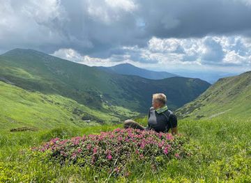
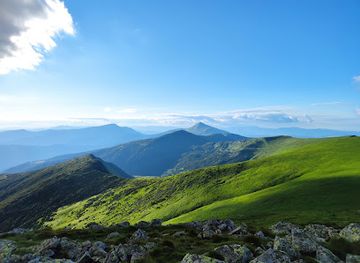
The Chornohora Range forms the highest section of the Ukrainian Carpathians, extending across western Ukraine near the borders of Zakarpattia and Ivano-Frankivsk oblasts. Its broad grassy ridges rise above spruce and beech forests, with the country’s highest summit, Hoverla, reaching 2,061 metres. Other notable peaks include Brebeneskul, Pip Ivan Chornohirskyi, Petros and Turkul. The upper slopes are shaped by open subalpine meadows, glacial cirques, rocky ridges and small mountain lakes, including Lake Brebeneskul and Nesamovyte. Weather changes quickly at altitude, and the range’s character shifts markedly between forested valleys, summer pasture and exposed summits.Read more about Chornohora Range
Hutsul Heritage and Mountain Communities
Walking, Conservation and Historic Sites
When is the best time to visit Chornohora Range?
Best: June–August · 15–17°C| Month | High (°C) | Rainfall (mm) |
|---|---|---|
| January | -3 | 36 |
| February | -2 | 31 |
| March | 2 | 34 |
| April | 6 | 37 |
| May | 12 | 35 |
| June (best) | 15 | 33 |
| July (best) | 17 | 30 |
| August (best) | 17 | 29 |
| September | 13 | 31 |
| October | 8 | 34 |
| November | 2 | 36 |
| December | -1 | 37 |
Getting to and around Chornohora Range
How to get there
Transportation
Best attractions in Chornohora Range
The principal attraction of Chornohora is its chain of high summits and open ridges. Hoverla, Ukraine’s highest mountain, is approached by popular routes from the north and south, while Petros offers a broad outlook towards the surrounding Carpathians. Pip Ivan Chornohirskyi combines a demanding summit walk with the weathered ruins of the White Elephant observatory. Between the peaks, Lake Brebeneskul occupies a high glacial hollow and Nesamovyte provides another atmospheric mountain-lake setting, though both require serious walking access rather than a casual roadside visit. Forest tracks and pastures lead through the valleys around Bystrets, Dzembronia and Verkhovyna, where Hutsul architecture, shepherding traditions and local museums provide cultural context. The northern gateway area around Vorokhta and Yaremche offers easier access to lower Carpathian scenery, while protected forests within the Carpathian National Nature Park introduce a different landscape from the exposed upper ridges.
-
Mountain range
Chornohirsʹkyy Zapovidnyy Masyv
Discover the breathtaking landscapes and rich biodiversity of Chornohirsʹkyy Zapovidnyy Masyv, a natural gem in Zakarpattia Oblast.
Best landmarks in Chornohora Range
Hoverla is Chornohora’s defining natural landmark and the highest point in Ukraine, while the neighbouring summits of Petros, Brebeneskul and Pip Ivan Chornohirskyi mark the range’s most prominent skyline. The high lakes Brebeneskul and Nesamovyte are important glacial and post-glacial landscape features, set among open meadows and cirques above the forest belt. On Pip Ivan, the abandoned White Elephant observatory is the range’s most recognisable historic structure, its massive stone shell recalling the former Polish scientific and frontier presence of the late 1930s. Lower down, Hutsul villages, wooden churches and traditional pasture landscapes connect the mountain landmarks with living regional culture. Protected forests and alpine habitats are landmarks in an ecological sense as well as scenic ones, and their value depends on limiting erosion, disturbance and unmanaged development.
-
Mountain range
Chornohirsʹkyy Zapovidnyy Masyv
Discover the breathtaking beauty and rich biodiversity of Chornohirsʹkyy Zapovidnyy Masyv in the heart of Ukraine's Zakarpattia Oblast.
Explore Chornohora Range on the map
Plan your trip on one map. See where the top attractions, landmarks, restaurants and hotels are, and book hotels and experiences in a few clicks.
Best hotels in Chornohora Range
Get your free copy of our complete guide to Chornohora Range, delivered straight to you.
Everything on this page, from attractions and restaurants to essentials and local phrases, in one PDF you can read offline, print or share.
Already have an account? Sign in
Your Chornohora Range guide is ready.
We'll send it to · Not you? Sign out

Getting your guide ready…
We are putting together a fresh copy of the Chornohora Range guide. This can take up to a minute.
This can take a few moments. If your browser asks, choose Allow so the download can start. You'll find the guide in your Downloads folder.
Nothing happened? Download it again
Sorry, the guide is taking longer than usual. Please try again in a minute, or get it by email instead.
Chornohora Range essentials
Currency and Payment
Safety
Emergency Situations
Do's and Don'ts
Local Tips
From Eve
Local phrases worth knowing
You don't need to get them perfect. A few words go a long way, and locals appreciate the effort.
Basics
| English | Local | Say it |
|---|---|---|
| Hello | Привіт | [pryvit] |
| Goodbye | До побачення | [do pobachennya] |
| Yes | Так | [tak] |
| No | Ні | [ni] |
| Please/You're welcome | Будь ласка | [bud laska] |
| Thank you | Дякую | [dyakuyu] |
| Excuse me/Sorry | Вибачте | [vybachte] |
| How are you? | Як справи? | [yak spravy?] |
| Fine. And you? | Добре. А ви? | [dobre. A vy?] |
| Do you speak English? | Ви говорите англійською? | [vy hovoryte anhliysʹkoyu?] |
| I don't understand | Я не розумію | [ya ne rozumiyu] |
Eating & Drinking
| English | Local | Say it |
|---|---|---|
| I'd like to see the menu, please | Я би хотів подивитися меню, будь ласка | [ya bi hotiv podyvytysya menyoo, bud laska] |
| I don't eat meat | Я не їм м'ясо | [ya ne yim m'yaso] |
| Cheers! | Будьмо! | [budʹmo!] |
| I would like to pay, please | Я би хотів заплатити, будь ласка | [ya bi hotiv zaplatyty, bud laska] |
Emergencies
| English | Local | Say it |
|---|---|---|
| Help! | Допоможіть! | [dopomozhitʹ!] |
| Go away! | Піди геть! | [pidy hetʹ!] |
| Call the Police! | Викличте поліцію! | [vyklychte politsiyu!] |
| Call a doctor! | Викличте лікаря! | [vyklychte likarya!] |
| I'm lost | Я загубився | [ya zahubyvsya] |
| I'm ill | Я хворий | [ya khvoryy] |
Shopping
| English | Local | Say it |
|---|---|---|
| I'd like to buy... | Я би хотів купити... | [ya bi hotiv kupyty...] |
| I'm just looking | Я просто дивлюся | [ya prosto dyvlyusya] |
| How much is it? | Скільки це коштує? | [skilʹky tse koshtuye?] |
| That's too expensive | Це занадто дорого | [tse zanadto doroho] |
| Can you lower the price? | Чи можете ви знизити ціну? | [chy mozhete vy znyzyty tsinu?] |
Time & Numbers
| English | Local | Say it |
|---|---|---|
| What time is it? | Яка година? | [yaka hodyna?] |
| It's one o'clock | Одна година | [odna hodyna] |
| Half past (10) | Половина (десятої) | [polovyna (desyatoyi)] |
| Morning | Ранок | [ranok] |
| Afternoon | День | [denʹ] |
| Evening | Вечір | [vechir] |
| Yesterday | Вчора | [vchora] |
| Today | Сьогодні | [sohodni] |
| Tomorrow | Завтра | [zavtra] |
| 1 | Один | [odyn] |
| 2 | Два | [dva] |
| 3 | Три | [try] |
| 4 | Чотири | [chotyry] |
| 5 | П'ять | [pyatʹ] |
| 6 | Шість | [shistʹ] |
| 7 | Сім | [sim] |
| 8 | Вісім | [visim] |
| 9 | Дев'ять | [dev'yatʹ] |
| 10 | Десять | [desyatʹ] |
Transport & Directions
| English | Local | Say it |
|---|---|---|
| Where's a/the...? | Де є/знаходиться...? | [de ye/znakhodytsya...?] |
| What's the address? | Яка адреса? | [yaka adresa?] |
| Can you show me (on the map)? | Чи можете ви мені показати (на мапі)? | [chy mozhete vy meni pokazaty (na mapi)?] |
| When's the next (bus)? | Коли наступний (автобус)? | [koly nastupnyy (avtobus)?] |
| A ticket (to ....) | Квиток (до ...) | [kvitok (do ...)] |
History of Chornohora Range
Carpathian Formation and Glacial Landscapes
Chornohora belongs to the Eastern Carpathians, a folded mountain system formed through geological uplift rather than a single volcanic event. Erosion, frost and past glacial activity shaped the range’s broad summits, cirques, steep valleys and high tarns. The contrast between rounded grassy ridges and deeply forested slopes is one of its defining physical characteristics. Lakes such as Brebeneskul and Nesamovyte occupy high mountain hollows, while the upper slopes support subalpine vegetation distinct from the spruce and beech forests below. These natural processes provide the geographical foundation for the range’s later pastoral culture, tourism and conservation history.
Hutsul Settlement and Pastoral Life
For centuries, communities in the surrounding valleys developed a livelihood adapted to steep terrain, long winters and limited arable land. Hutsul society became associated with seasonal pastoralism, forest use, small-scale farming, horse breeding, woodworking, weaving and distinctive musical traditions. Shepherds moved animals to high summer pastures, where temporary settlements and traditional cheese-making formed part of the mountain economy. Villages including Verkhovyna, Bystrets, Dzembronia and settlements around the Prut valley remain connected with this cultural landscape, although modern employment, transport and tourism have changed the older seasonal pattern.
Imperial Borders and Regional Change
Before the twentieth century, Chornohora lay within the changing political world of the Habsburg monarchy, with administrative boundaries passing through the wider Carpathian region. Roads and mountain passes connected communities across upland valleys, while forestry and timber became increasingly important industries. The area’s inhabitants were exposed to the political and military upheavals of the First World War, when the Carpathians formed part of a contested frontier. After the collapse of the Austro-Hungarian Empire, the range was incorporated into the Second Polish Republic, while the southern and western approaches followed different political trajectories in the wider Carpathian borderlands.
The White Elephant Observatory
One of Chornohora’s most distinctive historic structures is the former astronomical and meteorological observatory on Pip Ivan Chornohirskyi. Built in the late 1930s by the Polish authorities on the summit, the substantial stone building was intended to support scientific observation and serve as a high-altitude frontier facility. Its popular name, the White Elephant, refers to the building’s pale appearance and later abandoned condition. The observatory was damaged and left unused after the political and military changes of the Second World War. Its ruins now illustrate the difficult relationship between science, remote infrastructure and a heavily contested mountain border.
Protected Landscapes and Modern Mountaineering
During the twentieth century, changing state borders, forestry policies and conservation priorities reshaped access to the Ukrainian Carpathians. Much of the Chornohora area is now managed through protected landscapes, notably the Carpathian National Nature Park and the Carpathian Biosphere Reserve in the broader region. Protection reflects the importance of old forests, alpine meadows, peatlands, mountain lakes and wildlife habitats rather than simply scenic value. Since the late Soviet period and Ukraine’s independence, hiking, ski tourism and Hutsul cultural tourism have expanded, while responsible management remains essential in a fragile environment receiving increasing visitor attention.
Chornohora Range in Photos
Browse through our photo collection highlighting the charm and character of the destination.
Neighbouring destination travel guides
The closest destinations to Chornohora Range, if you have time for more than one.
-

-

-

-

-


Swipe for more destinations
Explore more

Explore more of Transcarpathia
Discover the untouched beauty and rich cultural tapestry of Transcarpathia, a hidden gem in Ukraine, perfect for nature lovers, history enthusiasts, and wellness seekers.
Explore Transcarpathia
Explore more of Ukraine
Explore Ukraine: From Kyiv's golden domes to the Carpathian Mountains, discover a country rich in history, culture, and natural beauty in the heart of Eastern Europe.
Explore Ukraine