Haresfield Topograph
A three-dimensional map landmark on the Cotswold escarpment with panoramic views toward Wales.
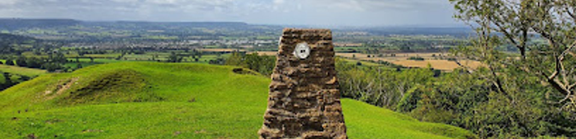
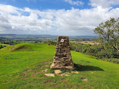
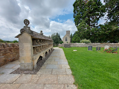
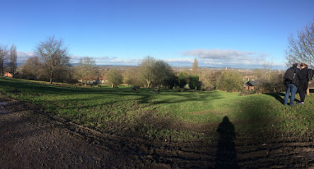
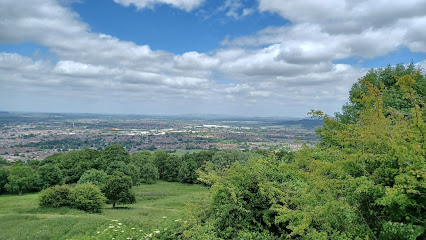
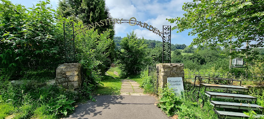
Perched on the Cotswold escarpment near Stroud, Haresfield Topograph is a distinctive three-dimensional map landmark offering sweeping views across the Severn estuary toward the Forest of Dean and Brecon Beacons. This Grade II listed structure serves as both a viewpoint and educational tool, helping visitors identify prominent features in the surrounding landscape. Set within mixed woodland and open grassland, the site combines natural beauty with historical significance, having been a location of Iron Age and Roman settlements.
A brief summary to Haresfield Topograph
- Cotswold Way, Stroud, GL6 6PP, GB
- Duration: 1 to 4 hours
- Free
-
 Outdoor
- Mobile reception: 1 out of 5
Local tips
- Visit during sunrise or sunset for stunning light and fewer crowds; the topograph's position on three spurs creates particularly dramatic silhouettes at these times.
- Bring sturdy, waterproof walking boots—the terrain is undulating with steep sections, and the escarpment can be muddy after rain.
- Pack a picnic and allow time to sit and study the topograph's three-dimensional map; understanding the labeled features enriches the panoramic view significantly.
- Check weather conditions before visiting; wind is common on the exposed hilltops, and visibility can be limited in low cloud or mist.
- Dogs are welcome but must remain on leads; the site is designated as a one-pawprint rated place with long walks suitable for dogs and owners.
For the on-the-go comforts that matter to you
- Drink Options
- Food Options
- Seating Areas
- Picnic Areas
- Trash Bins
- Information Boards
Getting There
-
Car with Parking
From Stroud town center, head north on the A46 toward Cheltenham. After approximately 2 kilometers, turn onto Cotswold Way (signposted for Haresfield). Continue for roughly 1 kilometer until you reach the parking area. Parking is available via a pay-by-app system using JustPark (Location ID: 998936): £1 for up to 1 hour, £3 for up to 3 hours, £4 for all day. National Trust members park free upon validating membership in the app. Arrive early during peak season (spring and summer weekends) as spaces are limited. Travel time from Stroud: approximately 10–15 minutes.
-
Public Bus
From Stroud town center, take the number 63 bus toward Stonehouse. Journey time is approximately 15–20 minutes. Request the stop for Cotswold Way or Haresfield. From the bus stop, follow Cotswold Way on foot for approximately 15–20 minutes to reach the topograph. One-way bus fare is approximately £2–£3. Check local timetables for current schedules, as service frequency varies seasonally.
-
Walking from Stroud
Begin at Stroud town center and follow Cotswold Way signage northward. The walk to Haresfield Topograph is approximately 3 kilometers and takes 45–60 minutes depending on fitness and pace. The route follows a mix of town paths and rural trails. Wear comfortable walking boots, bring water, and allow extra time if you're unfamiliar with the route. The terrain becomes more undulating as you approach the escarpment.
-
Cotswold Way Long-Distance Trail
If walking the Cotswold Way itself, Haresfield Topograph and Beacon serve as a waypoint on Leg 9 of the trail. The approach follows peaceful woodland tracks before emerging onto windswept hillsides. This is a stile-free section of the trail. Journey time depends on your starting point along the trail; allow 2–4 hours if walking from nearby sections.
Haresfield Topograph location weather suitability
-
 Clear Skies
-
 Mild Temperatures
-
 Any Weather
Discover more about Haresfield Topograph
A Landmark Carved into the Cotswold Escarpment
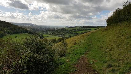
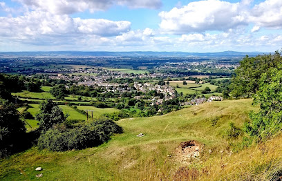
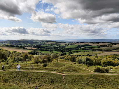
Haresfield Topograph stands as a remarkable viewpoint on the Cotswold escarpment, occupying a prominent position on three spurs that jut dramatically into the landscape. The topograph itself is a three-dimensional map structure, ingeniously designed to help visitors identify and locate significant landmarks visible from this elevated vantage point. Rather than simply offering a passive view, the topograph transforms the experience into an interactive educational encounter, allowing you to connect the physical landscape before you with the named features etched into the structure. The views from Haresfield are nothing short of extraordinary. On clear days, your gaze sweeps across the Severn estuary toward the Forest of Dean and the distant Brecon Beacons, creating a panorama that captures the essence of the Welsh Marches and English countryside. The undulating terrain beneath your feet—a mix of exposed hilltops and steep slopes—reinforces the dramatic topography that makes this location so visually compelling.Woodland Walks and Historic Ground
The site encompasses far more than the topograph itself. Haresfield Beacon and Standish Wood together form a substantial estate offering varied experiences across mixed woodland and open grassland. Intimate beech and yew woodlands provide shelter and shade, while flower-strewn limestone grasslands open onto windswept hillsides. The terrain is undulating and uneven, with steep sections that demand respect and sturdy footwear, but this very character creates the dramatic landscape that defines the location. Beneath your feet lies deep historical resonance. The site was occupied during the Iron Age and Roman periods, with evidence of ancient settlements embedded in the escarpment. An ancient burial mound—a Bronze Age monument—sits within the woodland, a silent witness to millennia of human presence. Walking these paths means treading ground where people have gathered for thousands of years, drawn by the same commanding views and defensible position that you experience today.Gateway to the Cotswold Way
Haresfield Topograph sits directly on the Cotswold Way, one of England's most celebrated long-distance walking trails. This positioning makes it an ideal waypoint for walkers tackling sections of the trail or undertaking the full 102-mile journey from Chipping Campden to Bath. The trail approaches through peaceful woodland tracks before emerging onto the windswept hillsides, creating a natural rhythm of shelter and exposure that heightens the drama of arrival at the topograph. The walking opportunities around the site are extensive. Short woodland strolls through beech and yew provide intimate nature experiences, while longer routes across the grasslands and along the escarpment edge offer sustained views and physical challenge. The variety of terrain and vegetation means the landscape shifts with the seasons—spring bluebells carpet the woodland floor, summer brings wildflowers to the grasslands, autumn transforms the canopy, and winter reveals the skeletal beauty of the trees and the raw power of the exposed hilltops.Practical Considerations and Seasonal Character
The site's exposure on the escarpment means weather plays a significant role in the experience. Windy conditions are common, particularly on the open grasslands and hilltops, while poor mobile phone signal is a consistent feature due to the rural location and terrain. The undulating ground with steep sections requires appropriate footwear and fitness levels, though shorter walks are available for those seeking less demanding routes. Visitation patterns vary throughout the year and across the day. Spring and early summer attract the most visitors, particularly when bluebells bloom and wildflowers flourish. Sunrise and sunset offer particularly rewarding lighting conditions and typically see fewer crowds. Winter visits provide their own appeal—clearer air often means more extensive views, and the absence of summer vegetation opens sightlines across the landscape. The site remains accessible year-round, though winter weather can occasionally make steep sections challenging.Iconic landmarks you can’t miss
Haresfield Topograph
0.0 km
A three-dimensional map landmark on the Cotswold escarpment with panoramic views toward Wales.
Walk The Cotswolds
4.5 km
Explore the Cotswolds' breathtaking landscapes and charming villages with Walk The Cotswolds, your gateway to England's picturesque countryside adventures.
Eastgate viewing chamber
10.0 km
Discover Gloucester’s ancient Roman and medieval city defenses through a unique underground viewing chamber beneath Eastgate Street.
Visit Cotswolds Online
10.4 km
Explore the enchanting Cotswolds, where rolling hills, historic villages, and breathtaking landscapes await every traveler seeking an unforgettable adventure.

Gloucestershire Historic Churches Trust
10.4 km
Explore the rich ecclesiastical heritage of Gloucestershire through its historic churches, showcasing stunning architecture and engaging community initiatives.

The Bee Shelter, Hartpury
15.9 km
Discover Hartpury’s unique 19th-century Bee Shelter, a stunning stone monument celebrating Gloucestershire’s rich beekeeping heritage and Victorian craftsmanship.
National Trust - Newark Park
16.0 km
Explore the historical elegance and natural beauty of Newark Park, a stunning country house and museum in the heart of the Cotswolds.
Dean Heritage Centre
16.5 km
Uncover the rich heritage of the Forest of Dean at the Dean Heritage Centre, where history meets nature in an engaging and family-friendly environment.

The Ancient Ram Inn (Advance Book only)
16.6 km
Experience the rich history and haunting tales at The Ancient Ram Inn, a captivating tourist attraction in Wotton-under-Edge, UK.
National Trust - Ashleworth Tithe Barn
16.8 km
Explore the historic Ashleworth Tithe Barn, a beautifully preserved medieval structure showcasing England's agricultural heritage amidst stunning countryside.
Dr Jenner's House
17.0 km
Explore the historic home of Edward Jenner, the father of vaccination, and immerse yourself in the birthplace of a medical revolution.
Berkeley Castle
17.1 km
Uncover the rich history and stunning beauty of Berkeley Castle, a timeless treasure in the heart of England, perfect for adventurers and history lovers alike.

Highgrove Gardens
17.4 km
Explore the breathtaking beauty of Highgrove Gardens, a masterpiece of horticulture and sustainability nestled in the Cotswolds.

Montpellier Gardens
17.8 km
Explore the beauty and tranquility of Montpellier Gardens, a charming park in Cheltenham adorned with stunning floral displays and serene pathways.

Colesbourne Gardens
18.0 km
Explore the breathtaking landscapes of Colesbourne Gardens, a serene escape in Cheltenham, perfect for nature lovers and those seeking tranquility.
Unmissable attractions to see
The Malthouse Collective
3.0 km
Discover timeless antiques and artisan crafts in Stroud’s vibrant Malthouse Collective, where history and creativity unite.

Museum in the Park
3.3 km
Explore Stroud’s heritage and art in a historic wool merchant’s house, with engaging exhibits and a serene Walled Garden in Stratford Park.
Cotswold Way
3.8 km
Explore 102 miles of stunning hills, historic sites, and charming villages on England’s iconic Cotswold Way National Trail.
Sim's Clock
4.0 km
Explore the historical Sim's Clock in Stroud, a charming landmark that reflects the town's rich heritage and vibrant community spirit.

Made In Stroud
4.0 km
Discover authentic handmade gifts and local artisan treasures in the heart of Stroud’s creative community.

Painswick Rococo Garden
4.1 km
Discover the UK’s only complete rococo garden, where whimsical follies, vibrant blooms, and a playful maze await in a tranquil Cotswold valley.
Swift's Hill Nature Reserve
5.3 km
Explore the vibrant limestone grasslands of Swift's Hill with rare orchids, panoramic views, and rich wildlife in Gloucestershire's cherished nature reserve.
Selsley Common
5.4 km
Explore Selsley Common’s ancient limestone grassland with rare orchids, historic barrows, and sweeping views over the Severn Valley in the Cotswolds.
Painswick Beacon
5.4 km
Discover the breathtaking views and historical significance of Painswick Beacon, a stunning landmark in the heart of the Cotswolds.
Summit of Robinswood Hill
6.8 km
Soak up panoramic views from the summit of Robinswood Hill, a green outlier of the Cotswolds with wildflower meadows, ancient woodland and Jurassic geology just minutes from Gloucester.
Robinswood Hill Country Park
6.9 km
Explore 100 hectares of scenic trails, wildlife habitats, and panoramic views just minutes from Gloucester city centre.
Rea Swing Bridge
7.0 km
Historic 19th-century iron swing bridge offering tranquil canal views and a glimpse into Gloucester’s maritime heritage.
Woodchester Mansion Trust
7.3 km
A hauntingly beautiful, unfinished Victorian Gothic mansion hidden in a tranquil Cotswold valley, offering a rare glimpse into architectural ambition and a haven for rare bats.
Prinknash Abbey Park
7.4 km
Discover serene monastic heritage and vibrant wildlife in the tranquil gardens and parklands of Prinknash Abbey Park near Gloucester.
Robinswood Country Park
7.5 km
Explore 100 hectares of diverse habitats, panoramic views, and rich history at Robinswood Hill Country Park near Gloucester.

Essential places to dine
Fagin's
3.9 km
A charming family-friendly English pub in Brookthorpe serving hearty steaks, classic carveries, and warm hospitality in a relaxed setting.
Miller & Carter Gloucester
6.1 km
Experience expertly cooked steaks and warm hospitality at Miller & Carter Gloucester in the heart of Quedgeley’s Olympus Park.

The Long Table
7.1 km
A pay-as-you-can community restaurant in Stroud serving locally sourced meals that nourish both body and spirit.
Wilder
9.2 km
Discover an intimate fine dining adventure in Nailsworth with inventive tasting menus and expertly paired wines at Wilder.

Bill's Gloucester Quays Restaurant
9.7 km
A relaxed, modern British restaurant at Gloucester Quays, perfect for a post-shopping meal or casual catch-up with friends and family.
Côte Gloucester
9.7 km
Modern French brasserie offering refined cuisine and warm service in Gloucester Quays, now closed but fondly remembered.

The Tall Ship
9.7 km
Historic Grade II listed pub in Gloucester Docks offering excellent British food, great beer, live music, and a lively social atmosphere.

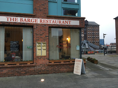
The Barge
9.8 km
A cozy family-run spot in Gloucester Docks serving hearty English classics with a welcoming bring-your-own-drinks policy.
Settebello Trattoria
9.9 km
Experience authentic Italian flavors with panoramic dockside views at Gloucester’s beloved Settebello Trattoria.

Aroma
9.9 km
Authentic Indian and Bangladeshi flavors served with impeccable hospitality in the heart of Gloucester’s historic Southgate Street.

Greek on the Docks
9.9 km
Experience authentic Greek cuisine and vibrant Mediterranean flavors with stunning waterfront views in the heart of Gloucester Docks.

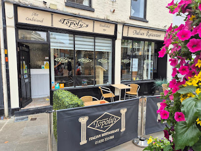
Topoly's
10.0 km
Authentic family-run Italian dining in the heart of Gloucester, serving fresh homemade dishes since 1990 in a lively, welcoming atmosphere.
Tiger's Eye Restaurant
10.1 km
Historic Gloucester’s Tiger's Eye offers interactive Pan-Asian fusion dining with hot rock grilling and a vibrant cocktail bar atmosphere.
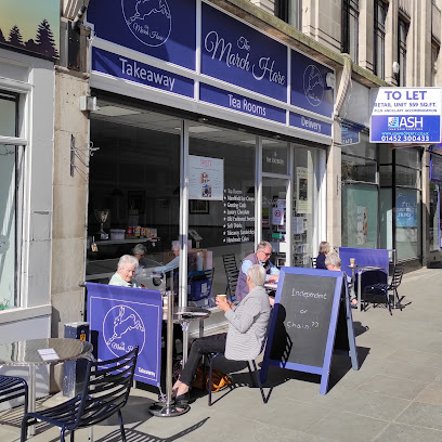
The March Hare
10.2 km
A cozy tearoom in Gloucester’s historic Oxbode offering fresh local fare and friendly service from morning to afternoon.
Bangkok Canteen Gloucester
10.3 km
Gloucester’s premier gluten-free Thai restaurant blending authentic flavors with sustainable, locally sourced ingredients in a cozy city-center setting.

Markets, malls and hidden boutiques
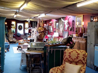
Adana Collective Antiques
3.0 km
Discover timeless treasures and beautiful antiques at Adana Collective, a curated gem in Stroud’s vibrant Salmon Springs Trading Estate.
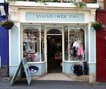
Moonflower Too
3.9 km
A vibrant gift shop in Stroud’s historic High Street, blending unique homewares with local charm and ethical brands.
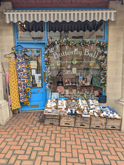
Butterfly Ball
4.0 km
Discover mindful gifts and spiritual treasures in Stroud’s welcoming Butterfly Ball shop, a hub for creativity and community since 2011.
Duffle Vintage
4.0 km
Authentic 60s and 70s vintage fashion in intimate, inspiring room settings.

Cotswold Creates
8.8 km
Discover unique artisan gifts and handcrafted treasures that capture the heart of the Cotswolds in Gloucester’s welcoming Cotswold Creates.

The Little Gift Shop
8.9 km
Curated gifts and local treasures in the heart of Nailsworth's independent retail scene.

Handmade Cotswolds
9.0 km
Discover exquisite handmade crafts and unique artisan gifts in the heart of Stroud’s vibrant Cotswolds community.

Gloucester Quays
9.5 km
Discover designer bargains and festive charm at Gloucester Quays, a lively waterfront outlet set within historic docks.

Gift Company
9.6 km
Discover unique gifts and charming homeware at The Gift Company, nestled in the vibrant Gloucester Quays outlet by the historic docks.

King's Walk
10.0 km
Gloucester’s central shopping destination featuring popular high street brands and convenient dining in a lively city centre setting.

Upstairs Downstairs
10.0 km
Discover Gloucester’s charming antique shop with unique collectibles and a cozy tearoom serving homemade treats.
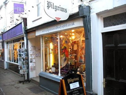
Pilgrims Gloucester
10.3 km
Discover unique gifts and a cosy, atmospheric shopping experience in the heart of historic Gloucester.
L&S Lifestyle
10.3 km
Discover unique gifts and stylish finds in a cozy boutique setting at L&S Lifestyle, Gloucester’s charming gift shop on College Street.
Chez Rose
10.4 km
Discover unique gifts and shabby chic treasures in a warm, welcoming boutique nestled in Gloucester’s historic Westgate Street.

Westgate Retail Park
10.6 km
Convenient shopping with free parking and a variety of homeware stores in the heart of Gloucester’s Westgate Street.

Essential bars & hidden hideouts
The Bumble Bee
5.0 km
A charming gastropub in Gloucester blending traditional warmth with quality seasonal dining and real ales in a relaxed setting.
Barn Owl
5.4 km
A friendly, family- and dog-welcoming pub in Quedgeley offering classic British fare, cask ales, and a warm, spacious setting with outdoor gardens.
Three Oaks Inn
7.7 km
A welcoming gastropub in Gloucester’s Robinswood, blending traditional charm with modern comfort and community spirit.
Cotswold Mobile Bar Hire
8.1 km
Bringing bespoke, fully stocked mobile bars with rustic charm and quirky inflatable pubs to your Cotswold events.

Avenue
8.5 km
A lively, dog-friendly pub in Gloucester serving classic fare and drinks in a welcoming Victorian setting with a vibrant community spirit.
One Eyed Jacks
9.7 km
A vibrant traditional pub in Gloucester blending classic charm with lively entertainment and friendly atmosphere.

Brewhouse & Kitchen - Gloucester Quays
9.7 km
A vibrant gastropub and microbrewery at Gloucester Quays offering craft beers, hearty meals, and waterfront views in a lively, modern setting.

The Weighbridge Inn
9.7 km
Historic 17th-century Cotswolds pub famed for its unique 2in1 pies, local ales, and warm, rustic charm.

Devoted Deluxe - Mobile Bar Hire
9.7 km
Elegant mobile bar hire in Gloucester delivering bespoke cocktails and personalized service for every special occasion.

TANK
9.7 km
Discover Gloucester’s premier craft beer bar with a lively atmosphere, local brews, stonebaked pizzas, and a welcoming beer garden in the historic docks.

Our House Bar
10.0 km
A vibrant cocktail and wine bar in Gloucester Docks offering curated drinks and a welcoming atmosphere for memorable nights out.

Café René
10.0 km
A lively Gloucester pub and restaurant blending historic charm, award-winning food, and vibrant live music in the city centre.

The Drunken Duck
10.2 km
A vibrant Gloucester pub blending unique space, exceptional beers, and a welcoming atmosphere for all to enjoy.
The Sword Inn Gloucester
10.2 km
Historic Gloucester pub blending tradition, community spirit, and lively sports in a welcoming city centre setting.
The Fountain Inn
10.3 km
Charming Grade II listed pub in Gloucester’s city centre offering real ales, hearty British fare, and a cozy historic atmosphere with garden and function rooms.
Nightclubs & after hour spots
Trio Nightclub
4.0 km
Experience Stroud’s vibrant nightlife at Trio Nightclub, where music, dancing, and energetic vibes light up weekend nights.

ATIK Gloucester
9.8 km
Gloucester’s largest nightclub, ATIK pulses with vibrant music, student nights, and an energetic party atmosphere until the early hours.

Jax Nightclub Gloucester
9.9 km
Energetic nightclub in Gloucester offering diverse music, two dance floors, and a welcoming atmosphere for late-night fun.

Bar Fever Gloucester
10.0 km
Experience Gloucester’s vibrant nightlife at Bar Fever, a trendy nightclub with dynamic music, stylish interiors, and a welcoming atmosphere.

Capones
12.5 km
Historic nightclub in Dursley with legendary ties to Al Capone, offering vibrant weekend nightlife and pulsating music.

Under the Prom
18.1 km
Experience Cheltenham’s vibrant nightlife with premium drinks, three unique bars, and VIP service at Under The Prom nightclub.

Thirteen Degrees
18.2 km
Cheltenham’s late-night hotspot for dancing, cocktails, and private events in a central urban setting.

Home and Botanic Nightclub
18.2 km
Historic charm meets vibrant nightlife at Cheltenham’s Home and Botanic, a multi-room club offering cocktails, live piano, DJs, and unforgettable nights.

MooMoo Clubrooms Cheltenham
18.2 km
Experience Cheltenham’s vibrant nightlife with dynamic music, VIP vibes, and late-night energy at MooMoo Clubrooms.

Popworld - Cheltenham
18.2 km
Cheltenham’s lively late-night hotspot where cheesy pop tunes and creative cocktails fuel unforgettable party nights.

The 21 Club
18.3 km
Experience Cheltenham’s vibrant nightlife at The 21 Club, where music, dancing, and great drinks create unforgettable nights.

Coco
18.4 km
Cheltenham’s underground hotspot for vibrant nightlife, top DJs, and creative cocktails in a lively basement setting.

2 PIGS
18.6 km
A lively Cheltenham nightclub with dual rooms spinning rock, punk, indie, and classic hits, known for affordable drinks and an alternative vibe.

ReVA Nightclub
20.5 km
Cirencester’s largest nightclub offering electrifying music, stylish cocktails, and a vibrant atmosphere for unforgettable nights.

The Club, Monmouth
32.1 km
Discover the heart of Monmouth's pub culture at The Club, where great food, drinks, and sports come together for an unforgettable experience.

For the vibe & atmosphere seeker
- Scenic
- Adventurous
- Tranquil
- Unique
For the design and aesthetic lover
- Vintage Styles
- Rustic Designs
For the architecture buff
- Historic
- Landmarks
- Viewpoints
- Parks & Gardens
- Heritage Neighborhoods
For the view chaser and sunset hunter
- Iconic Views
- Panoramas
- Sunrise Spots
- Sunset Spots
For the social media creator & influencer
- Instagrammable
- Photo Spots
- Architectural Shots
- Panoramas
For the eco-conscious traveler
- Protected Area
- Locally Managed
- Wildlife Habitat
- Leave-No-Trace Critical
For the kind of experience you’re after
- Myth & Legends
- Cultural Heritage
- Photowalk
- Nature Escape
- Day Trip
- Weekend Getaway
For how adventurous you want the journey to be
- Easy Access
- Requires Hike
- Physically Demanding
Location Audience
- Family Friendly
- Senior Friendly
- Child Friendly
- Pet Friendly
- Solo Friendly
- Couple Friendly


