

Cotopaxi National Park Travel Guide - Free Web & App
Your ultimate guide to Cotopaxi National Park. Discover top landmarks, proposed trips, and local tips. Free on the web or via the Evendo companion app.


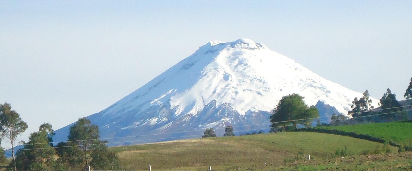


Cotopaxi National Park in Ecuador offers volcano views, Limpiopungo lagoon, Andean wildlife, hiking and high-altitude landscapes near Quito and Latacunga.
Volcanic Landscapes
Cotopaxi National Park lies in the Ecuadorian Andes, principally between Quito and Latacunga, and is named after the near-perfect snow-capped volcano that dominates its skyline. Cotopaxi rises to about 5,897 metres and is one of the world's highest active volcanoes. Its broad slopes, glacial summit and stark volcanic form are the park's defining sight, although the protected landscape extends well beyond the mountain itself. Open páramo grasslands, volcanic plains, small wetlands and dark lava-strewn slopes create a high-altitude environment shaped by cold, wind and intense sunlight.Read more about Cotopaxi National Park
Wildlife and Water
Exploring the Park
When is the best time to visit Cotopaxi National Park?
Best: June–August · 12–13°C| Month | High (°C) | Rainfall (mm) |
|---|---|---|
| January | 14 | 178 |
| February | 13 | 185 |
| March | 13 | 181 |
| April | 13 | 151 |
| May | 13 | 93 |
| June (best) | 13 | 42 |
| July (best) | 12 | 41 |
| August (best) | 12 | 45 |
| September | 12 | 65 |
| October | 12 | 112 |
| November | 12 | 137 |
| December | 12 | 152 |
Getting to and around Cotopaxi National Park
How to get there
Transportation
Best attractions in Cotopaxi National Park
The defining attraction is Cotopaxi itself, whose symmetrical cone and glaciated upper slopes rise above a broad volcanic landscape. Limpiopungo lagoon is the park's best-known accessible viewpoint, reflecting the volcano when skies are clear and providing a setting for short walks and birdwatching. The lower Cotopaxi refuge area and mountain approaches offer a sense of the high-altitude environment, although access towards the summit depends on conditions, acclimatisation and official regulations. Rumiñahui, an eroded volcanic massif to the west, provides a contrasting hiking objective and broad views across the páramo. Open grasslands, lava fields and wetlands reveal the park's geological and ecological variety, while occasional sightings of Andean foxes, deer, wild llamas and highland birds add a wildlife dimension. The surrounding Avenue of the Volcanoes, including nearby rural valleys and hacienda landscapes, extends the experience beyond the park without being part of its protected boundaries.
-
Nature preserve
Condor Machay Cascadas
Explore the breathtaking Condor Machay Cascadas, a nature preserve near Quito filled with stunning waterfalls, diverse wildlife, and lush landscapes.
-
Museum
Cotopaxi Visitors Center
Explore the Cotopaxi Visitors Center in Ecuador, where breathtaking landscapes and rich biodiversity await every traveler seeking nature's wonders.
-
Tourist attraction
laguna Santo Domingo
Explore the stunning beauty of Laguna Santo Domingo, a serene lake in El Mudadero, Ecuador, perfect for nature lovers and adventure seekers alike.
-
Tourist attraction
El Manantial
Discover the serene beauty of El Manantial, a stunning tourist attraction in El Mudadero, Ecuador, perfect for nature enthusiasts and explorers alike.


Best landmarks in Cotopaxi National Park
Cotopaxi volcano is the park's principal natural landmark, recognised by its near-symmetrical cone, permanent upper snow and active volcanic status. Limpiopungo lagoon is an important scenic and ecological landmark, set within open páramo beneath views of Cotopaxi and Rumiñahui. Rumiñahui itself is significant as an eroded volcanic massif whose broken ridges contrast with Cotopaxi's smooth cone. The park's lava-strewn slopes, volcanic plains and high wetlands reveal the forces that shaped the Avenue of the Volcanoes, while the páramo vegetation reflects the harsh conditions of the upper Andes. Outside the protected area, the surrounding valleys and historic hacienda landscapes provide cultural landmarks linked to agriculture and colonial landholding. These features should be understood as parts of a wider volcanic and rural setting, rather than as an urban collection of monuments.
-
Tourist attraction
Cotopaxi- Administration National Park
Explore the stunning landscapes and vibrant ecosystems of Cotopaxi National Park, home to one of the world's highest active volcanoes.
-
National park
Parque Nacional Cotopaxi
Experience the breathtaking landscapes and rich biodiversity of Parque Nacional Cotopaxi, a must-visit national park in Ecuador.
-
Museum
Cotopaxi Visitors Center
Discover the rich heritage and stunning landscapes surrounding Cotopaxi at the Visitors Center, your gateway to Ecuador's breathtaking national park.
-
National park
Volcan Cotopaxi
Experience the breathtaking beauty and adventure of Volcan Cotopaxi, one of the highest active volcanoes in the world, nestled in Ecuador's stunning national park.


Explore Cotopaxi National Park on the map
Plan your trip on one map. See where the top attractions, landmarks, restaurants and hotels are, and book hotels and experiences in a few clicks.
Best hotels in Cotopaxi National Park
Best restaurants in Cotopaxi National Park
Dining inside Cotopaxi National Park is limited, so visitors normally eat before entering, carry provisions or return to nearby settlements. Machachi, north of the park, is known as a practical base for exploring the highlands and offers restaurants, cafés and traditional Ecuadorian meals, while Latacunga provides a broader range of eateries to the south. Regional cooking commonly includes soups, potatoes, maize, grains and locally produced dairy, reflecting the agricultural character of the Andean valleys; Ecuadorian specialities such as locro de papas may appear on menus, although availability varies. Rural roadside establishments and hacienda-style venues may serve hearty meals suited to cool mountain weather. Visitors should not expect a restaurant network around Limpiopungo or the upper mountain, and those planning an early excursion should arrange food and water in advance.
-
Restaurant
Mirador De Los Volcanes Cotopaxi-Ecuador
Experience exquisite Ecuadorian cuisine with breathtaking views at Mirador De Los Volcanes in Cotopaxi.
-
Restaurant
Chasqui Mirador Cotopaxi
Discover Chasqui Mirador Cotopaxi: Enjoy authentic Ecuadorian cuisine with breathtaking views near Cotopaxi National Park.
-
Restaurant
Cuscungo Restaurante
Experience authentic Ecuadorian cuisine at Cuscungo Restaurante near Cotopaxi – where local flavors meet breathtaking views.
-
Restaurant
Cotopaxi CaraSur. Refugio
Discover authentic Ecuadorian cuisine at Cotopaxi CaraSur while enjoying breathtaking views near Cotopaxi National Park.


Best bars in Cotopaxi National Park
Cotopaxi National Park has no significant nightlife scene, and evenings are generally quiet once visitors leave the highland roads and return to their accommodation. Traditional restaurants, hotel lounges and local drinking establishments in Machachi and Latacunga provide the main opportunities for a relaxed drink or conversation, rather than late-night entertainment. In Machachi, the atmosphere reflects a working Andean town and gateway to rural attractions; Latacunga has a larger urban centre with more cafés and bars, although it is still considerably quieter than Quito. Rural lodges and haciendas may offer communal evening spaces, but facilities vary and should not be assumed. Daylight, altitude and early departures for the park often make a calm evening more practical than a night out.
-
Hostel
The Secret Garden Cotopaxi
Experience the beauty of Ecuador at The Secret Garden Cotopaxi, your gateway to adventure and tranquility in the heart of nature.
-
 Restaurant
Rondador Cotopaxi
Discover culinary delights and thrilling adventures at Rondador Cotopaxi, your gateway to the breathtaking landscapes of Cotopaxi National Park.
-
Restaurant
Mirador De Los Volcanes Cotopaxi-Ecuador
Savor authentic Ecuadorian cuisine with breathtaking views of Cotopaxi at Mirador De Los Volcanes, a culinary gem in Latacunga.
-
Restaurant
Hacienda San Agustin de Callo
Experience the enchanting blend of history, culture, and adventure at Hacienda San Agustin de Callo, a unique destination in Ecuador.


Best nightclubs in Cotopaxi National Park
Cotopaxi National Park has no significant nightlife scene, and evenings are generally quiet once visitors leave the highland roads and return to their accommodation. Traditional restaurants, hotel lounges and local drinking establishments in Machachi and Latacunga provide the main opportunities for a relaxed drink or conversation, rather than late-night entertainment. In Machachi, the atmosphere reflects a working Andean town and gateway to rural attractions; Latacunga has a larger urban centre with more cafés and bars, although it is still considerably quieter than Quito. Rural lodges and haciendas may offer communal evening spaces, but facilities vary and should not be assumed. Daylight, altitude and early departures for the park often make a calm evening more practical than a night out.
-
National park
Parque Nacional Cotopaxi
Discover the breathtaking beauty of Cotopaxi National Park, home to stunning landscapes and one of the world's highest active volcanoes.
-
Bar
Gastro Bar Karaoke El CHOZON
Discover the vibrant nightlife of Latacunga at Gastro Bar Karaoke El CHOZON, where delicious drinks and karaoke fun await every visitor.


Best shops in Cotopaxi National Park
Shopping within Cotopaxi National Park is very limited, with no extensive retail area around the principal natural attractions. Visitors usually buy snacks, water, outdoor necessities and locally made products in Machachi or Latacunga before travelling into the protected landscape. In surrounding Andean towns, small markets and independent shops may sell agricultural produce, dairy products, woven goods, woollen clothing and souvenirs associated with Ecuador's highland cultures, although the range and operating pattern vary. Latacunga is the larger commercial centre, while Machachi is convenient for northern approaches and rural supplies. Regional food products can be more meaningful purchases than generic souvenirs, but visitors should distinguish commercially produced items from genuinely local crafts and ask permission before photographing artisans or stalls.
-
Tourist attraction
Cotopaxi- Administration National Park
Experience the breathtaking landscapes and rich biodiversity of Cotopaxi National Park, home to the iconic Cotopaxi volcano and stunning Andean wildlife.
-
National park
Parque Nacional Cotopaxi
Experience the breathtaking beauty and adventure of Cotopaxi National Park, Ecuador's iconic natural treasure.
-
Hostel
The Secret Garden Cotopaxi
Experience the serene beauty of Cotopaxi at The Secret Garden, a charming hostel offering adventure, comfort, and local culture in Ecuador.
-
Lumber store
Aglomerados Cotopaxi S.A
Explore Aglomerados Cotopaxi S.A., where Ecuador's rich lumber heritage meets sustainable craftsmanship in a picturesque setting.


Get your free copy of our complete guide to Cotopaxi National Park, delivered straight to you.
Everything on this page, from attractions and restaurants to essentials and local phrases, in one PDF you can read offline, print or share.
Already have an account? Sign in
Your Cotopaxi National Park guide is ready.
We'll send it to · Not you? Sign out

Getting your guide ready…
We are putting together a fresh copy of the Cotopaxi National Park guide. This can take up to a minute.
This can take a few moments. If your browser asks, choose Allow so the download can start. You'll find the guide in your Downloads folder.
Nothing happened? Download it again
Sorry, the guide is taking longer than usual. Please try again in a minute, or get it by email instead.
Cotopaxi National Park essentials
Currency and Payment
Safety
Emergency Situations
Do's and Don'ts
Local Tips
From Eve
Local phrases worth knowing
You don't need to get them perfect. A few words go a long way, and locals appreciate the effort.
Basics
| English | Local | Say it |
|---|---|---|
| Hello | ¡Hola! | [O-lah] |
| Goodbye | ¡Adiós! | [Ah-dee-ohs] |
| Yes | Sí | [See] |
| No | No | [Noh] |
| Please/You're welcome | Por favor/De nada | [Por fah-vor/De nah-dah] |
| Thank you | Gracias | [Grah-see-ahs] |
| Excuse me/Sorry | Disculpe/Perdón | [Dees-cool-peh/Pehr-dohn] |
| How are you? | ¿Cómo estás? | [Koh-moh ehs-tahs] |
| Fine. And you? | Bien. ¿Y tú? | [Bee-ehn. Ee too] |
| Do you speak English? | ¿Hablas inglés? | [Ah-blahs een-glehs] |
| I don't understand | No entiendo | [Noh ehn-tee-ehn-doh] |
Eating & Drinking
| English | Local | Say it |
|---|---|---|
| I'd like to see the menu, please | Me gustaría ver el menú, por favor | [Meh goo-stah-ree-ah behr ehl meh-noo, poor fah-vor] |
| I don't eat meat | No como carne | [Noh koh-moh kahr-neh] |
| Cheers! | ¡Salud! | [Sah-lood] |
| I would like to pay, please | Me gustaría pagar, por favor | [Meh goo-stah-ree-ah pah-gahr, poor fah-vor] |
Emergencies
| English | Local | Say it |
|---|---|---|
| Help! | ¡Ayuda! | [Ah-yoo-dah] |
| Go away! | ¡Vete! | [Beh-teh] |
| Call the Police! | ¡Llama a la Policía! | [Yah-mah ah lah Poh-lee-see-ah] |
| Call a doctor! | ¡Llama a un doctor! | [Yah-mah ah oon dohk-tohr] |
| I'm lost | Estoy perdido | [Ehs-toy pehr-dee-doh] |
| I'm ill | Estoy enfermo | [Ehs-toy ehn-fehr-moh] |
Shopping
| English | Local | Say it |
|---|---|---|
| I'd like to buy... | Me gustaría comprar... | [Meh goo-stah-ree-ah kohm-prahr...] |
| I'm just looking | Solo estoy mirando | [Soh-loh ehs-toy mee-rahn-doh] |
| How much is it? | ¿Cuánto cuesta? | [Kwan-to kweh-stah] |
| That's too expensive | Esto es demasiado caro | [Ehs-toh ehs deh-mah-syah-doh kah-roh] |
| Can you lower the price? | ¿Puede bajar el precio? | [Pweh-deh bah-har ehl preh-syoh] |
Time & Numbers
| English | Local | Say it |
|---|---|---|
| What time is it? | ¿Qué hora es? | [Keh oh-rah ehs] |
| It's one o'clock | Es la una | [Ehs lah oo-nah] |
| Half past (10) | Diez y media | [Dyehs ee meh-dee-ah] |
| Morning | Mañana | [Mah-nyah-nah] |
| Afternoon | Tarde | [Tahr-deh] |
| Evening | Noche | [Noh-cheh] |
| Yesterday | Ayer | [Ah-yehr] |
| Today | Hoy | [Oy] |
| Tomorrow | Mañana | [Mah-nyah-nah] |
| 1 | Uno | [Oo-noh] |
| 2 | Dos | [Dohs] |
| 3 | Tres | [Tres] |
| 4 | Cuatro | [Kwah-troh] |
| 5 | Cinco | [Seen-koh] |
| 6 | Seis | [Says] |
| 7 | Siete | [Syeh-teh] |
| 8 | Ocho | [Oh-choh] |
| 9 | Nueve | [Nweh-veh] |
| 10 | Diez | [Dyehs] |
Transport & Directions
| English | Local | Say it |
|---|---|---|
| Where's a/the...? | ¿Dónde está...? | [Dohn-deh ehs-tah] |
| What's the address? | ¿Cuál es la dirección? | [Kwahl ehs lah dee-rehk-syohn] |
| Can you show me (on the map)? | ¿Puedes mostrarme (en el mapa)? | [Pweh-dehs mohs-trar-meh (ehn ehl mah-pah)] |
| When's the next (bus)? | ¿Cuándo es el próximo (bus)? | [Kwan-doh ehs ehl proh-ksee-moh (boos)] |
| A ticket (to ....) | Un boleto (a ...) | [Oon boh-leh-toh (ah ...)] |
History of Cotopaxi National Park
Volcanic Formation and the Andean Setting
Cotopaxi National Park occupies part of the northern Ecuadorian Andes, a landscape formed by long-term volcanic activity and uplift along the Pacific Ring of Fire. Cotopaxi is a stratovolcano built from successive layers of lava, ash and other volcanic material, while Rumiñahui represents a more deeply eroded volcanic massif. Glacial ice on Cotopaxi and the area's high-elevation wetlands continue to influence drainage and habitats. The park's páramo is not simply empty upland: it is a water-regulating ecosystem whose grasses, peat-forming soils and wetlands are important to the wider Andean environment.
Indigenous Landscapes and Andean Routes
The region around Cotopaxi has long been inhabited and used by Indigenous Andean communities, including peoples associated with the Panzaleo cultural area around present-day Cotopaxi Province. Farming, grazing and movement between highlands and lower valleys shaped the relationship between communities and the páramo. The Inca state later incorporated parts of the central Ecuadorian Andes into its realm, followed by Spanish conquest and colonial administration. Although the national park is primarily valued today for its natural environment, its surrounding landscapes remain connected to Indigenous communities, rural livelihoods and longstanding highland routes.
Colonial Landholding and Highland Agriculture
During the colonial period and after Ecuador's independence, large estates and haciendas became influential features of the valleys and uplands surrounding Cotopaxi. Cattle grazing, agriculture and the use of high-altitude pasture altered parts of the páramo, while nearby settlements developed as service and trading centres. The area was also crossed by routes linking Quito with the southern Andes, helping connect rural estates and villages with larger regional markets. Many visitors now encounter this history through the cultivated valleys, historic hacienda landscapes and enduring agricultural patterns beyond the park's core natural areas.
Eruptions and the Growth of Mountain Tourism
Cotopaxi's eruptive history has repeatedly affected the surrounding region. The volcano produced damaging eruptions in the nineteenth century, including the major eruption of 1877, when lahars travelled down its flanks and river valleys. Reports of activity and eruptions had already made the mountain a subject of scientific and geographical interest. During the nineteenth and twentieth centuries, mountaineers, explorers and travellers increasingly visited Cotopaxi, establishing its place in Ecuador's developing mountain-tourism tradition. The volcano's active status remains central to how access and climbing conditions are managed.
National Park Protection
Cotopaxi National Park was established in 1975 to protect the volcano, páramo ecosystems, wetlands and surrounding highland landscapes. Its creation reflected the growing recognition that Ecuador's volcanic mountains were important not only for scenery and recreation but also for water systems, biodiversity and scientific study. Tourism has since expanded, particularly through day visits from Quito, Latacunga and Machachi, while conservation authorities have had to balance access with erosion control, wildlife protection and volcanic risk management. Conditions and visitor restrictions can change according to weather, hazards and official decisions.
Cotopaxi National Park in Photos
Browse through our photo collection highlighting the charm and character of the destination.
Neighbouring destination travel guides
The closest destinations to Cotopaxi National Park, if you have time for more than one.
-

-

-

-
-


Swipe for more destinations
Explore more
Explore more of Cotopaxi Region
Explore the Cotopaxi Region: Home to Ecuador's iconic volcano, rich cultural heritage, and breathtaking landscapes perfect for adventure and relaxation.
Explore Cotopaxi Region
Explore more of Ecuador
Explore Ecuador: From the Amazon rainforest and Andean highlands to the Pacific coast and Galápagos Islands, discover diverse landscapes and vibrant cultures.
Explore Ecuador