Background

Dreieckiger Pfahl: A Historical Landmark in the Harz

Discover the historical Dreieckiger Pfahl in the Harz Mountains, a landmark marking centuries of German borders and offering scenic hiking trails through stunning landscapes.

4.6

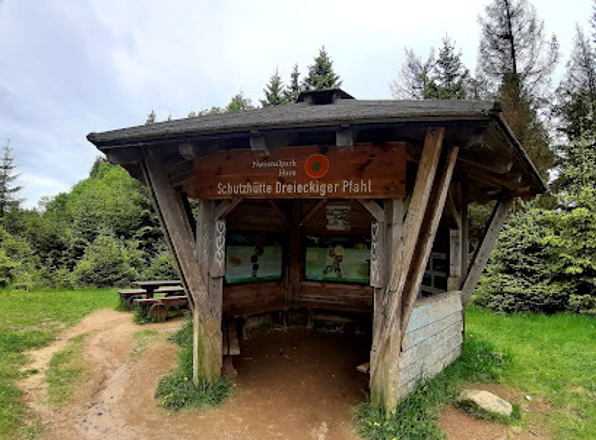
The Dreieckiger Pfahl, or Triangular Post, is a historic granite boundary stone located in the Harz Mountains. Erected before 1866, it originally marked the tripoint border between the Kingdom of Hanover and the Duchy of Brunswick. During the Cold War, it stood along the border between East and West Germany, adding another layer to its historical significance. Today, it marks the boundary between Lower Saxony and Saxony-Anhalt. Situated at an elevation of approximately 870 meters, the Dreieckiger Pfahl is a popular destination for hikers exploring the Harz National Park. The landmark is a testament to the region's complex past and offers a tangible connection to German history. The surrounding area provides scenic trails suitable for various skill levels, making it an accessible and rewarding experience for nature enthusiasts and history buffs alike. A nearby rest area allows hikers to pause and reflect on the historical importance of this unique location, nestled within the beautiful Harz landscape. The Dreieckiger Pfahl serves as a reminder of the ever-changing political landscape of Germany and its enduring natural beauty.

A brief summary to Dreieckiger Pfahl

  • Harz, DE

Local tips

  • Wear sturdy hiking shoes as the trails around Dreieckiger Pfahl can be uneven and rocky.
  • Bring water and snacks, especially if you plan on hiking to the Brocken, as there are limited options for refreshments along the trails.
  • Check the weather forecast before you go, as conditions in the Harz Mountains can change quickly.
  • Consider visiting during the off-season (spring or fall) to avoid crowds and enjoy the scenery in peace.
  • Explore the Harz Border Trail for a deeper understanding of the region's Cold War history.
widget icon

Getting There

  • Driving

    From the B4 federal road between Torfhaus and Oderbrück, park at the designated car park. Parking fees typically range from €2-€5 for the day. From the car park, follow the well-marked hiking trails east for approximately 2.5 kilometers to reach the Dreieckiger Pfahl. The hike is relatively easy and takes about 45 minutes to an hour.

  • Public Transport

    From Wernigerode, take Bus 251 towards Braunlage. Get off at the Braunlage, ZOB station and transfer to Bus 820 towards Oderbrück. Alight at the Oderbrück stop. From Oderbrück, follow the hiking trails east for approximately 2.5 kilometers to reach the Dreieckiger Pfahl. Ensure to check the bus schedules in advance as services may be infrequent, especially on weekends and holidays. A single bus fare from Wernigerode to Oderbrück will cost approximately €6-€8.

  • Walking

    If you are hiking from Braunlage, follow the signs towards the Brocken via the Dreieckiger Pfahl. The hike is approximately 11.7 kilometers and takes around 3-4 hours. Alternatively, from Torfhaus, follow the Goetheweg towards the Brocken. The Dreieckiger Pfahl is located approximately 6 kilometers from Torfhaus along this route.

Unlock the Best of Dreieckiger Pfahl

Buy tickets

    No tickets available

Book tours with entry

    No tours available

Book tours without entry

    No tours available

Discover more about Dreieckiger Pfahl

The Dreieckiger Pfahl, a seemingly simple granite pillar, holds within it centuries of German history and the echoes of shifting borders. Located in the heart of the Harz Mountains, southwest of the Brocken peak, this unassuming landmark stands as a silent witness to the region's complex past. Erected before 1866, the Dreieckiger Pfahl, translated as "Triangular Post," originally marked the meeting point of three distinct territories: the Kingdom of Hanover, the Duchy of Brunswick, and the Elbingerode side. This tripoint location gave the stone its name and its initial significance as a marker of political boundaries. The earliest recorded mention of a boundary stone at this location dates back to 1727, with maps referencing a marker as early as 1698. Over the centuries, the boundary markers were replaced with wooden and stone posts, until the current triangular granite stone was erected. The stone bears the number "1" and inscriptions on its northeastern and southwestern sides, remnants of its original purpose. According to historical descriptions, the original post featured a wolfsangel, gashes, and a cross, along with the year 1698, further solidifying its role as a boundary marker. The wolfsangel, in particular, has a long history as a symbol used in boundary marking in the region. However, the Dreieckiger Pfahl's story doesn't end with its role as a marker of kingdoms and duchies. The division of Germany after World War II added another layer of historical weight to the site. During the Cold War, the Dreieckiger Pfahl found itself along the heavily fortified border between East and West Germany. Accessible only from the west during this period, the stone became a poignant symbol of division and the separation of families and communities. Today, the Dreieckiger Pfahl marks the border between the states of Lower Saxony and Saxony-Anhalt, a far less contentious boundary than those it has witnessed in the past. It stands at an elevation of approximately 870 meters, about 2.5 kilometers east of a car park on the B4 federal road between Torfhaus and Oderbrück, making it a popular destination for hikers exploring the Harz National Park. The surrounding landscape offers a variety of hiking trails, catering to different skill levels and interests. The trails wind through dense forests, open moorlands, and rocky terrain, providing stunning views of the Harz Mountains. The ascent to the Brocken, the highest peak in the Harz, is a popular trek, with many routes passing by the Dreieckiger Pfahl. For those interested in the history of the inner-German border, the Dreieckiger Pfahl serves as a starting point for exploring remnants of the former fortifications and border installations. The Harz Border Trail, a long-distance hiking route, passes by the Dreieckiger Pfahl, offering hikers a chance to reflect on the region's divided past. The Dreieckiger Pfahl is more than just a stone; it's a symbol of German history, a reminder of shifting borders, and a testament to the enduring power of nature. Whether you're a history buff, a nature enthusiast, or simply looking for a scenic hike, a visit to the Dreieckiger Pfahl is a rewarding experience. While a small restaurant once stood near the Dreieckiger Pfahl, catering to hikers on their way to the Brocken, it was unfortunately burned down in 1945. Today, a rest area near the stone provides a place for hikers to pause, reflect, and enjoy the tranquility of the Harz Mountains. The Dreieckiger Pfahl refuge is also located nearby, offering shelter and a place to rest. The Dreieckiger Pfahl is easily accessible from several starting points, including Torfhaus, Oderbrück, and Braunlage. Public transportation options are available, with buses connecting the nearby towns to trailheads. For those arriving by car, parking is available near the B4 federal road, although fees may apply. The Dreieckiger Pfahl is a destination that combines natural beauty with historical significance. It's a place where you can immerse yourself in the tranquility of the Harz Mountains while contemplating the complex history of Germany. Whether you're a seasoned hiker or a casual visitor, the Dreieckiger Pfahl offers a unique and rewarding experience.

Popular Experiences near Dreieckiger Pfahl

Popular Hotels near Dreieckiger Pfahl

Select Currency