

Pico Bonito National Park Travel Guide - Free Web & App
Your ultimate guide to Pico Bonito National Park. Discover top landmarks, proposed trips, and local tips. Free on the web or via the Evendo companion app.


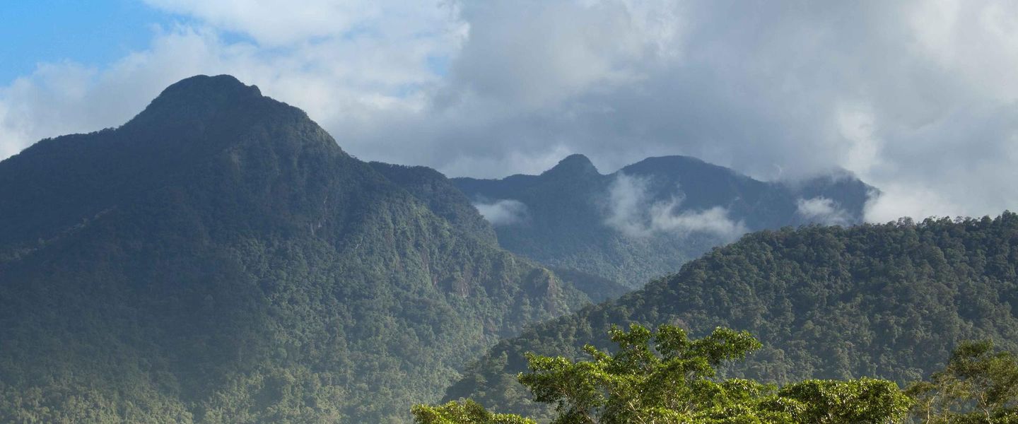


Pico Bonito National Park, Honduras, offers Caribbean rainforest, mountain trails, waterfalls, wildlife, birdwatching and river adventures near La Ceiba.
Rainforest and High Mountain Landscapes
Pico Bonito National Park rises abruptly behind La Ceiba on Honduras’s Caribbean coast, protecting a vast sweep of the Nombre de Dios mountain range. Its terrain climbs from humid lowland forest and river valleys towards Pico Bonito, a sharply defined summit reaching about 2,435 metres. The park’s steep slopes, deep ravines and fast-flowing waterways create several distinct environments within a relatively compact coastal region, although the protected area itself is too extensive to experience in a single outing.Read more about Pico Bonito National Park
Rivers, Wildlife and Conservation
Exploring from the Caribbean Coast
When is the best time to visit Pico Bonito National Park?
Best: January–March · 32–33°C| Month | High (°C) | Rainfall (mm) |
|---|---|---|
| January (best) | 32 | 87 |
| February (best) | 32 | 79 |
| March (best) | 33 | 74 |
| April | 33 | 79 |
| May | 33 | 114 |
| June | 33 | 141 |
| July | 33 | 144 |
| August | 33 | 137 |
| September | 33 | 131 |
| October | 33 | 107 |
| November | 33 | 89 |
| December | 33 | 84 |
Getting to and around Pico Bonito National Park
How to get there
Transportation
Best attractions in Pico Bonito National Park
The Río Cangrejal Valley is the park’s most accessible and atmospheric visitor area, combining forested slopes, rushing water, suspension bridges and viewpoints towards the Nombre de Dios mountains. Guided trails in and around the valley lead through humid tropical forest where birdwatching and plant observation are major interests, while waterfalls and smaller tributaries become especially appealing after rainfall, subject to safe local conditions. The El Pino sector provides another approach to Pico Bonito’s forested foothills and is associated with trails and nature tourism, although access and facilities should be confirmed before travelling. Higher parts of the park are rugged and not suited to casual sightseeing, with routes requiring preparation and local knowledge. River activities on the Cangrejal, including rafting, are organised from the surrounding valley rather than available indiscriminately throughout the park. La Ceiba’s position at the forest edge makes it a useful base, but the city itself lies outside the protected area.
-
Tourist attraction
Muelle Turistico Reynaldo Canales
Explore Muelle Turistico Reynaldo Canales in La Ceiba for stunning coastal views, vibrant local culture, and delicious traditional cuisine.
-
Tourist attraction
Parador Fotografico LA CEIBA
Experience the breathtaking beauty of Parador Fotografico LA CEIBA, a premier tourist attraction in La Ceiba, where stunning landscapes meet vibrant local culture.
-
Hiking area
Malecón Ceiba
Experience breathtaking trails and coastal views at Malecón Ceiba, a stunning hiking area in La Ceiba, Honduras, perfect for nature lovers.
-
Las 3 Posas Balneario
Experience the enchanting natural pools of Las 3 Posas Balneario in La Ceiba, a serene escape for relaxation and adventure amidst stunning landscapes.


Best landmarks in Pico Bonito National Park
Pico Bonito itself is the defining natural landmark, a high, steep-sided summit rising above the Caribbean plain and giving the national park its name. The wider Nombre de Dios range forms an equally important visual and ecological feature, with forested ridges, ravines and watersheds descending towards La Ceiba. The Río Cangrejal is the park’s best-known river landmark, valued for its clear mountain setting, rapids, bridges and connections with surrounding rainforest. Waterfalls and forest tributaries provide smaller landmarks along established routes, although their appearance and access can change with rainfall. The park’s significance lies less in monumental architecture than in the relationship between mountain forest, river systems and coastal communities. La Ceiba’s urban landmarks are nearby gateways rather than features within Pico Bonito National Park, and should be treated as part of the surrounding regional experience.
-
Park
Malecón Guillermo Anderson
Experience the beauty and tranquility of Malecón Guillermo Anderson, a stunning park in La Ceiba, with breathtaking coastal views and lush landscapes.
-
 Hotel
Apart Hotel Pico Bonito
Experience the perfect blend of comfort and nature at Apart Hotel Pico Bonito in La Ceiba, Honduras, your gateway to adventure and relaxation.
-
Hotel
The Lodge & Spa at Pico Bonito
Experience the perfect blend of luxury and adventure at The Lodge & Spa at Pico Bonito, where nature meets comfort in La Ceiba, Honduras.
-
Tourist attraction
Parque Nacional Pico Bonito
Discover Honduras's Pico Bonito National Park: A biodiversity hotspot with lush rainforests, cascading waterfalls, thrilling adventures, and rich cultural heritage near La Ceiba.


Explore Pico Bonito National Park on the map
Plan your trip on one map. See where the top attractions, landmarks, restaurants and hotels are, and book hotels and experiences in a few clicks.
Best hotels in Pico Bonito National Park
Best restaurants in Pico Bonito National Park
Pico Bonito National Park has limited dining infrastructure within its forested core, so meals are generally found at accommodation and activity lodges in the Río Cangrejal Valley, at rural eateries near access roads, or in La Ceiba outside the park. The region’s food reflects northern Honduran and Caribbean influences, with rice and beans, plantain, corn-based dishes, soups, grilled meats and seafood commonly associated with the wider coast. La Ceiba and nearby communities also provide the broadest choice of cafés, simple restaurants and provisions for picnics or guided outings. Garífuna culinary traditions are an important part of the Caribbean region’s cultural identity, although particular dishes and opening arrangements vary by establishment. Visitors heading into forest sectors should not expect regular restaurants or food shops and should confirm whether accommodation or an activity provider includes meals before travelling.
-
Restaurant
Cric Cric Burger
Discover delicious burgers at Cric Cric Burger in La Ceiba—where flavor meets fun along Honduras' picturesque coastline.
-
Restaurant
Nichas Burger La Ceiba
Discover delicious gourmet burgers at Nichas Burger La Ceiba – where flavor meets vibrant atmosphere in Honduras' coastal paradise.
-
Honduran
Restaurante TipiKtracho
Experience authentic Honduran cuisine at Restaurante TipiKtracho in La Ceiba – where every dish tells a story.
-
Hotel
The Lodge & Spa at Pico Bonito
Discover luxury and adventure amidst nature's paradise at The Lodge & Spa at Pico Bonito in Honduras.


Best bars in Pico Bonito National Park
Evening entertainment is concentrated outside Pico Bonito National Park, principally in La Ceiba, rather than within the protected forest. The Río Cangrejal Valley tends towards quiet evenings at guesthouses, lodges and rural dining venues, where the atmosphere is shaped by rushing water, mountain darkness and early starts for outdoor activities. La Ceiba has a broader selection of bars, casual evening venues and music associated with a Caribbean coastal city, though the character and availability of individual places change. Smaller communities near the park may have limited local establishments rather than a formal nightlife district. Visitors staying in the valley should arrange transport before drinking or travelling after dark, and should not expect late-night services, lighting or reliable public transport on mountain roads.
-
Bar
Luxor Lounge & Bar
Discover the vibrant nightlife of La Ceiba at Luxor Lounge & Bar, a premier destination for cocktails, music, and unforgettable experiences.
-
Bar
Mata de Chata
Experience the vibrant nightlife at Mata de Chata, La Ceiba's lively bar, offering delicious drinks and a welcoming atmosphere for all.
-
Bar
SOPRANOS BAR 0101
Experience the vibrant nightlife at Sopranos Bar 0101 in La Ceiba, where lively music meets delectable drinks in a welcoming atmosphere.
-
Bar
MARINE BAR and GRILL
Discover the lively Marine Bar and Grill in La Ceiba, where fresh seafood meets creative cocktails in a stunning tropical setting.


Best nightclubs in Pico Bonito National Park
Evening entertainment is concentrated outside Pico Bonito National Park, principally in La Ceiba, rather than within the protected forest. The Río Cangrejal Valley tends towards quiet evenings at guesthouses, lodges and rural dining venues, where the atmosphere is shaped by rushing water, mountain darkness and early starts for outdoor activities. La Ceiba has a broader selection of bars, casual evening venues and music associated with a Caribbean coastal city, though the character and availability of individual places change. Smaller communities near the park may have limited local establishments rather than a formal nightlife district. Visitors staying in the valley should arrange transport before drinking or travelling after dark, and should not expect late-night services, lighting or reliable public transport on mountain roads.
-
Hiking area
Parque Nacional Pico Bonito
Explore the breathtaking beauty of Parque Nacional Pico Bonito, a paradise for hikers and nature lovers in Honduras, showcasing lush landscapes and vibrant wildlife.
-
Bar
El Puma
Discover the vibrant nightlife at El Puma, a local bar in Atlántida offering an unforgettable blend of drinks, music, and a friendly atmosphere.
-
Bar
Tiger Bar HCM
Discover the lively atmosphere of Tiger Bar in La Ceiba, where refreshing drinks and local culture blend for an unforgettable night out.
-
Disco club
Impactos Discotec
Discover the Thrilling Nightlife at Impactos Discotec in El Porvenir - Dance, Music, and Unforgettable Moments Await!


Best shops in Pico Bonito National Park
Shopping inside Pico Bonito National Park is modest and centred on practical supplies, locally produced food and items sold by accommodation or community businesses rather than a defined retail district. La Ceiba, outside the park, is the main place to purchase provisions, outdoor essentials and locally made goods before travelling into the mountains. Visitors may encounter small rural shops, farm products and craft items in communities around access roads, but stock and opening arrangements vary. Northern Honduras is associated with tropical agriculture, coffee from upland areas, seafood and Caribbean cultural traditions, while Garífuna communities contribute distinctive music, foodways and artistic expression to the wider coast. Buy responsibly, ask about the origin of natural materials and avoid purchasing products made from protected wildlife, plants or illegally collected forest resources.
-
Hiking area
Parque Nacional Pico Bonito
Explore Parque Nacional Pico Bonito: A breathtaking hiking destination in Honduras with stunning landscapes, diverse wildlife, and exhilarating trails.
-
Stores and shopping
Souvenir El Buen Amigo
Discover authentic Honduran souvenirs at Souvenir El Buen Amigo in La Ceiba – a treasure trove of culture and craftsmanship.
-
Bakery
Panadería Pico Bonito
Discover the delightful flavors of La Ceiba at Panadería Pico Bonito, a bakery renowned for its exquisite pastries and warm atmosphere.
-
Furniture store
Tienda de muebles rústicos
Explore the unique charm of Honduras at Tienda de Muebles Rústicos, where handcrafted furniture tells the story of local artistry and tradition.


Get your free copy of our complete guide to Pico Bonito National Park, delivered straight to you.
Everything on this page, from attractions and restaurants to essentials and local phrases, in one PDF you can read offline, print or share.
Already have an account? Sign in
Your Pico Bonito National Park guide is ready.
We'll send it to · Not you? Sign out

Getting your guide ready…
We are putting together a fresh copy of the Pico Bonito National Park guide. This can take up to a minute.
This can take a few moments. If your browser asks, choose Allow so the download can start. You'll find the guide in your Downloads folder.
Nothing happened? Download it again
Sorry, the guide is taking longer than usual. Please try again in a minute, or get it by email instead.
Pico Bonito National Park essentials
Currency and Payment
Safety
Emergency Situations
Do's and Don'ts
Local Tips
From Eve
Local phrases worth knowing
You don't need to get them perfect. A few words go a long way, and locals appreciate the effort.
Basics
| English | Local | Say it |
|---|---|---|
| Hello | Hola | [oh-la] |
| Goodbye | Adiós | [ah-dee-ohs] |
| Yes | Sí | [see] |
| No | No | [no] |
| Please/You're welcome | Por favor/De nada | [por fah-vor/de nah-dah] |
| Thank you | Gracias | [grah-see-ahs] |
| Excuse me/Sorry | Disculpe/Lo siento | [dee-skool-pe/loh see-en-toh] |
| How are you? | ¿Cómo estás? | [koh-moh es-tahs] |
| Fine. And you? | Bien. ¿Y tú? | [bee-en. ee too] |
| Do you speak English? | ¿Hablas inglés? | [ah-blahs een-glays] |
| I don't understand | No entiendo | [noh en-tee-en-doh] |
Eating & Drinking
| English | Local | Say it |
|---|---|---|
| I'd like to see the menu, please | Me gustaría ver el menú, por favor | [may goos-tah-ree-ah ver el men-oo, por fah-vor] |
| I don't eat meat | No como carne | [noh koh-moh kar-neh] |
| Cheers! | ¡Salud! | [sah-lood] |
| I would like to pay, please | Me gustaría pagar, por favor | [may goos-tah-ree-ah pah-gar, por fah-vor] |
Emergencies
| English | Local | Say it |
|---|---|---|
| Help! | ¡Ayuda! | [ah-yoo-dah] |
| Go away! | ¡Vete! | [veh-teh] |
| Call the Police! | ¡Llame a la Policía! | [yah-meh ah lah poh-lee-see-ah] |
| Call a doctor! | ¡Llame a un médico! | [yah-meh ah oon meh-dee-koh] |
| I'm lost | Estoy perdido | [es-toy pehr-dee-doh] |
| I'm ill | Estoy enfermo | [es-toy en-fehr-moh] |
Shopping
| English | Local | Say it |
|---|---|---|
| I'd like to buy... | Me gustaría comprar... | [may goos-tah-ree-ah kohm-prar] |
| I'm just looking | Solo estoy mirando | [soh-loh es-toy mee-rahn-doh] |
| How much is it? | ¿Cuánto cuesta? | [kwan-toh kwehs-tah] |
| That's too expensive | Eso es demasiado caro | [eh-so es deh-mah-syah-doh kah-ro] |
| Can you lower the price? | ¿Puede bajar el precio? | [pweh-deh bah-har el preh-syoh] |
Time & Numbers
| English | Local | Say it |
|---|---|---|
| What time is it? | ¿Qué hora es? | [keh oh-rah es] |
| It's one o'clock | Es la una | [es lah oo-nah] |
| Half past (10) | Las diez y media | [lahs dee-ehs ee meh-dee-ah] |
| Morning | Mañana | [mah-nyah-nah] |
| Afternoon | Tarde | [tahr-deh] |
| Evening | Noche | [noh-cheh] |
| Yesterday | Ayer | [ah-yehr] |
| Today | Hoy | [oy] |
| Tomorrow | Mañana | [mah-nyah-nah] |
| 1 | Uno | [oo-noh] |
| 2 | Dos | [dohs] |
| 3 | Tres | [trehs] |
| 4 | Cuatro | [kwah-troh] |
| 5 | Cinco | [seen-koh] |
| 6 | Seis | [says] |
| 7 | Siete | [syeh-teh] |
| 8 | Ocho | [oh-choh] |
| 9 | Nueve | [nweh-veh] |
| 10 | Diez | [dee-ehs] |
Transport & Directions
| English | Local | Say it |
|---|---|---|
| Where's a/the...? | ¿Dónde está...? | [dohn-deh es-tah] |
| What's the address? | ¿Cuál es la dirección? | [kwal es lah dee-rehk-syon] |
| Can you show me (on the map)? | ¿Puede mostrarme (en el mapa)? | [pweh-deh mohs-trar-meh (en el mah-pah)] |
| When's the next (bus)? | ¿Cuándo es el próximo (bus)? | [kwan-doh es el proh-ksee-moh (boos)] |
| A ticket (to ....) | Un boleto (a ....) | [oon boh-leh-toh (ah)] |
History of Pico Bonito National Park
The Nombre de Dios Mountain Range
Pico Bonito National Park occupies part of the Nombre de Dios range, a mountainous system rising immediately south of Honduras’s Caribbean coast. Its steep relief, rainforest-covered slopes and river valleys reflect long geological processes rather than a single historical event. The mountains intercept moisture carried inland from the Caribbean, helping create the wet forest conditions for which the park is known. The contrast between lowland coastal plain and high, rugged interior has shaped settlement, transport and land use around the park, while the peaks have remained comparatively less developed than the surrounding coastal corridor.
Indigenous and Coastal Landscapes
The wider Caribbean region around Pico Bonito has long been connected with Indigenous peoples, including communities whose territories and cultural histories extend across northern Honduras. Garífuna communities became an important part of the country’s Caribbean identity after their arrival on the island of Roatán in the eighteenth century and subsequent settlement along the coast. The park itself is primarily a forested mountain landscape rather than a historic town, but its rivers, valleys and foothills belong to a region shaped by fishing, farming, forest use and movement between the coast and interior.
Agriculture and Settlement at the Foothills
During the nineteenth and twentieth centuries, northern Honduras developed stronger commercial links through ports, roads, agriculture and the growth of La Ceiba. Plantation agriculture and expanding settlement transformed parts of the coastal lowlands, while the mountains retained forested watersheds and difficult terrain. Communities in valleys such as the Río Cangrejal became points of contact between working rural landscapes and the protected forest. This boundary remains visible today, with farms, homes and tourism businesses concentrated near access roads while steeper slopes continue to provide habitat and water catchments.
National Park Protection
Pico Bonito National Park was established in 1987 as part of Honduras’s national protected-area system. Its purpose is closely linked to conserving the forests, watersheds and wildlife of the Nombre de Dios mountains, including habitats that descend towards the Caribbean lowlands. Management has involved public institutions, local organisations and conservation partners, with attention to sustainable livelihoods and responsible tourism. Protection does not make the entire area equally accessible: the park includes extensive rugged terrain, and visitor use is concentrated around recognised entrances, trails, rivers and nearby communities.
Tourism and Conservation Today
Since the late twentieth century, Pico Bonito has become one of northern Honduras’s principal nature-tourism destinations. La Ceiba and the Río Cangrejal Valley provide the main infrastructure for guided walks, birdwatching, rafting and rainforest visits, allowing tourism to support local employment while bringing attention to the park’s ecological importance. Modern conservation concerns include maintaining forest connectivity, protecting clean water and managing pressure at popular river and trail sites. Agriculture, roads and settlement continue to meet the park at its edges, making cooperation with neighbouring communities central to its future.
Pico Bonito National Park in Photos
Browse through our photo collection highlighting the charm and character of the destination.
Cities in Pico Bonito National Park
The towns and cities of Pico Bonito National Park, and the easiest places to base yourself.

Swipe for more cities
Neighbouring destination travel guides
The closest destinations to Pico Bonito National Park, if you have time for more than one.
-

-
-

-
-


Swipe for more destinations
Explore more

Explore more of Aguan Valley
Discover the breathtaking beauty and rich cultural tapestry of Aguan Valley, Honduras' hidden paradise for nature lovers, history buffs, and adventure seekers.
Explore Aguan Valley
Explore more of Honduras
Discover Honduras: From ancient Maya ruins and vibrant cities to stunning beaches and lush rainforests, this Central American gem offers something for every traveler.
Explore Honduras