

Wicklow Mountains Travel Guide - Free Web & App
Your ultimate guide to Wicklow Mountains. Discover top landmarks, proposed trips, and local tips. Free on the web or via the Evendo companion app.


Wicklow Mountains, Ireland: explore Glendalough, mountain valleys, lakes, forests and hiking routes near Dublin in a protected national park region.
Mountain Valleys and Open Moorland
The Wicklow Mountains form Ireland’s largest continuous upland area, rising south of Dublin across County Wicklow and extending towards parts of County Dublin, Wexford and Carlow. Their rounded granite summits, broad valleys, peatland plateaux, conifer plantations and dark lakes create a landscape that changes markedly with the weather. Much of the central area lies within Wicklow Mountains National Park, where open mountain terrain surrounds some of Ireland’s most accessible wilderness scenery.Read more about Wicklow Mountains
Glendalough and the National Park
Settlements and Outdoor Life
When is the best time to visit Wicklow Mountains?
Best: June–August · 18–21°C| Month | High (°C) | Rainfall (mm) |
|---|---|---|
| January | 9 | 71 |
| February | 10 | 67 |
| March | 10 | 67 |
| April | 12 | 64 |
| May | 15 | 69 |
| June (best) | 18 | 69 |
| July (best) | 21 | 63 |
| August (best) | 20 | 68 |
| September | 17 | 73 |
| October | 14 | 75 |
| November | 11 | 79 |
| December | 9 | 75 |
Getting to and around Wicklow Mountains
How to get there
Transportation
Best attractions in Wicklow Mountains
Glendalough is the Wicklow Mountains’ best-known attraction, combining two lakes, woodland paths and an early medieval monastic settlement with routes into the surrounding hills. In the northern mountains, the Sally Gap scenic road passes open moorland, Lough Tay and the valleys beneath Djouce, while the Wicklow Gap crosses a broad upland landscape between Glendalough and western Wicklow. Glenmalure offers a quieter setting of forest, river and steep valley sides, and Lugnaquilla provides the region’s highest summit for experienced hillwalkers in suitable conditions. The National Park’s trails also reveal blanket bog, upland grassland and recovering woodland, with occasional views towards the coast. Powerscourt Waterfall and Powerscourt Estate lie near Enniskerry on the eastern edge of the wider Wicklow tourism region rather than in the central national park. Villages including Laragh, Roundwood and Enniskerry add practical stops and cultural context to a largely rural landscape.
-
Pub
The Blue Light
Discover the lively atmosphere of The Blue Light, a must-visit pub in Dublin with stunning views, delicious food, and authentic Irish hospitality.
-
Amusement park
Clara Lara Funpark
Experience thrill and adventure at Clara Lara Funpark, a premier amusement park in the heart of Co. Wicklow, surrounded by Ireland's natural beauty.
-
National park
Glendalough
Explore the stunning landscapes and rich history of Glendalough, a national park in County Wicklow, perfect for hiking and nature lovers.
-
Historical landmark
The Hell Fire Club
Explore the haunting beauty and rich history of The Hell Fire Club in the Dublin Mountains, a must-visit landmark for every traveler.



Best landmarks in Wicklow Mountains
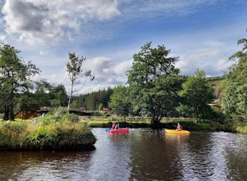
The monastic remains at Glendalough are the defining cultural landmarks of the Wicklow Mountains, with the tall round tower, churches, gateways and graveyards set between the Upper and Lower Lakes. Lugnaquilla is the highest mountain in County Wicklow and a major geographical reference point, although reaching its summit requires appropriate mountain experience and conditions. Djouce, the Sally Gap and the Wicklow Gap represent the open upland character of the region, while Lough Tay and Lough Dan are prominent mountain lakes shaped by the surrounding glacial terrain. Glenmalure is a landmark valley in both geographical and historical terms, associated with communications and conflict across the mountains. In the wider eastern foothills, Powerscourt Waterfall and the estate near Enniskerry are important visitor landmarks, but they should be treated as neighbouring attractions rather than features of the central national park.
-
Visitor center
Glendalough Visitor Centre
Explore the breathtaking landscapes and rich heritage at the Glendalough Visitor Centre in County Wicklow, where history meets nature.
-
Tourist attraction
Miners Village
Explore Miners Village in Wicklow, a captivating tourist attraction rich in mining history and surrounded by breathtaking landscapes.
-
Mountain peak
Great Sugar Loaf
Explore the stunning Great Sugar Loaf in Co. Wicklow, offering breathtaking views and a memorable hiking experience in the heart of Ireland's natural beauty.
-
Mountain peak
Fairy Castle
Discover breathtaking views and captivating trails at Fairy Castle, the scenic mountain peak of Co. Dublin offering a perfect escape into nature.


Explore Wicklow Mountains on the map
Plan your trip on one map. See where the top attractions, landmarks, restaurants and hotels are, and book hotels and experiences in a few clicks.
Best hotels in Wicklow Mountains
Best restaurants in Wicklow Mountains
Dining in the Wicklow Mountains is concentrated in villages and gateway settlements rather than beside remote trailheads. Laragh and nearby Glendalough provide the most convenient options for visitors exploring the southern and central parts of the national park, with cafés, restaurants and pubs serving food suited to walkers as well as residents. Roundwood and Enniskerry are useful bases in the north, while Wicklow town, Bray and Arklow offer a wider choice beyond the mountain area. Menus generally reflect Ireland’s contemporary rural cooking, using local dairy, meat, vegetables and seafood from the east coast where available, alongside familiar pub dishes and baked goods. Farm shops and village food businesses can be useful for preparing a picnic, but opening patterns vary and remote valleys have few places to buy provisions. Carrying food and water is sensible for longer walks.
-
Irish pub
Johnnie Fox's Pub
Discover the charm of Johnnie Fox's Pub in Glencullen – an iconic Irish pub offering delicious food and live music amidst breathtaking scenery.
-
Restaurant
Wicklow Heather Restaurant
Discover Wicklow Heather Restaurant: A local culinary treasure offering fresh Irish cuisine amidst breathtaking scenery.
-
 Restaurant
The Glenmalure Lodge
Discover traditional Irish hospitality at The Glenmalure Lodge - your perfect retreat in Wicklow's breathtaking landscapes.
-
Restaurant
Killruddery House & Gardens
Discover the historical charm and natural beauty of Killruddery House & Gardens in Co. Wicklow - a perfect blend of culture and tranquility.


Best bars in Wicklow Mountains
Evenings in the Wicklow Mountains are generally quiet and centred on traditional pubs, hotel bars and community venues in settlements such as Laragh, Roundwood, Enniskerry and nearby villages. These places may offer a social atmosphere, conversation, local drinks and occasional music or cultural events, but the area is not a late-night clubbing destination. Visitors staying in the central valleys should expect entertainment to be modest and facilities to close earlier than in Dublin or larger coastal towns. Bray, Wicklow and Arklow provide broader evening options outside the mountain core, although they require a journey by road. Rural roads are poorly suited to casual late-night driving, particularly in darkness or bad weather, so evening plans are best kept close to the chosen accommodation base.
-
Irish pub
Johnnie Fox's Pub
Experience the heart of Irish culture at Johnnie Fox's Pub, a historic venue offering traditional food, live music, and stunning mountain views.
-
Restaurant
Wicklow Heather Restaurant
Discover the flavors of Ireland at Wicklow Heather Restaurant, where local ingredients meet breathtaking views in County Wicklow.
-
Pub
The Hollywood Inn
Experience the heart of Irish hospitality at The Hollywood Inn, a cozy pub in Co. Wicklow with delightful food and drinks.
-
Pub
Grove Bar
Experience the warmth of Irish hospitality at Grove Bar, a charming pub in Delgany, County Wicklow, serving delicious food and drinks in a cozy atmosphere.


Best nightclubs in Wicklow Mountains
Evenings in the Wicklow Mountains are generally quiet and centred on traditional pubs, hotel bars and community venues in settlements such as Laragh, Roundwood, Enniskerry and nearby villages. These places may offer a social atmosphere, conversation, local drinks and occasional music or cultural events, but the area is not a late-night clubbing destination. Visitors staying in the central valleys should expect entertainment to be modest and facilities to close earlier than in Dublin or larger coastal towns. Bray, Wicklow and Arklow provide broader evening options outside the mountain core, although they require a journey by road. Rural roads are poorly suited to casual late-night driving, particularly in darkness or bad weather, so evening plans are best kept close to the chosen accommodation base.
-
Bar
Glen Lounge
Experience the warmth of Irish hospitality at Glen Lounge, a delightful bar in County Wicklow, perfect for unwinding with friends and local brews.
-
Night club
Koo Nightclub
Koo Nightclub in Bray: Where the Night Comes Alive with Music, Dancing, and Unforgettable Memories.


Best shops in Wicklow Mountains
Shopping within the Wicklow Mountains is limited and practical, with village shops, cafés, food outlets and small local businesses concentrated in Laragh, Roundwood, Enniskerry and nearby settlements. Visitors may find regional food products, baked goods, crafts, artwork and outdoor necessities, while larger selections are available in Bray, Wicklow town or Arklow outside the mountain core. Farm shops and producers in the wider county can offer items such as preserves, honey, dairy products and other Irish-made foods, although premises and stock vary. Glendalough’s visitor area provides opportunities to buy books, gifts and heritage-related items connected with the monastic site and national park. The region is better suited to buying useful provisions and locally made mementoes than to extensive retail browsing, and walkers should purchase essentials before entering remote valleys.
-
Store
Avoca Kilmacanoge
Discover the charm of Avoca Kilmacanoge, where gourmet food, unique gifts, and a cozy café await in the heart of County Wicklow.
-
Store
Avoca Powerscourt
Experience shopping and dining in the picturesque setting of Avoca Powerscourt, where local crafts meet delicious café delights in Co. Wicklow.
-
Clothing store
Fishers of Newtownmountkennedy Department Store
Explore fashion, gifts, and a cozy café at Fishers of Newtownmountkennedy, a unique shopping experience in beautiful County Wicklow.
-
Greengrocer
The Roundwood Stores
Discover fresh produce and unique local goods at The Roundwood Stores, the heart of Roundwood in Co. Wicklow, Ireland.


Get your free copy of our complete guide to Wicklow Mountains, delivered straight to you.
Everything on this page, from attractions and restaurants to essentials and local phrases, in one PDF you can read offline, print or share.
Already have an account? Sign in
Your Wicklow Mountains guide is ready.
We'll send it to · Not you? Sign out

Getting your guide ready…
We are putting together a fresh copy of the Wicklow Mountains guide. This can take up to a minute.
This can take a few moments. If your browser asks, choose Allow so the download can start. You'll find the guide in your Downloads folder.
Nothing happened? Download it again
Sorry, the guide is taking longer than usual. Please try again in a minute, or get it by email instead.
Wicklow Mountains essentials
Currency and Payment
Safety
Emergency Situations
Do's and Don'ts
Local Tips
From Eve
Local phrases worth knowing
You don't need to get them perfect. A few words go a long way, and locals appreciate the effort.
Basics
| English | Local | Say it |
|---|---|---|
| Hello | Dia dhuit | [dee-ah gwit] |
| Goodbye | Slán | [slawn] |
| Yes | Tá | [taw] |
| No | Níl | [neel] |
| Please/You're welcome | Le do thoil | [leh duh hull] |
| Thank you | Go raibh maith agat | [goh rev mah ah-gut] |
| Excuse me/Sorry | Tá brón orm | [taw brohn orum] |
| How are you? | Conas atá tú? | [kun-us ah-taw too] |
| Fine. And you? | Tá mé go maith. Agus tú? | [taw may goh mah. ah-gus too] |
| Do you speak English? | An bhfuil Gaeilge agat? | [ahn will gayl-guh ah-gut] |
| I don't understand | Ní thuigim | [nee hug-im] |
Eating & Drinking
| English | Local | Say it |
|---|---|---|
| I'd like to see the menu, please | Ba mhaith liom an mianu a fheiceáil, le do thoil | [bah wyh lum on mee-noo ah eck-ahl, leh duh hull] |
| I don't eat meat | Ní ithim feoil | [nee ih-him fuh-il] |
| Cheers! | Sláinte! | [slawn-cheh] |
| I would like to pay, please | Ba mhaith liom íoc, le do thoil | [bah wyh lum eek, leh duh hull] |
Emergencies
| English | Local | Say it |
|---|---|---|
| Help! | Cosaint! | [ko-sont] |
| Go away! | Imigh uaim! | [ih-mee oom] |
| Call the Police! | Glan an Gárda! | [glan on gawr-dah] |
| Call a doctor! | Glan dochtúir! | [glan duck-too-ir] |
| I'm lost | Tá mé caillte | [taw may kail-cheh] |
| I'm ill | Tá mé tinn | [taw may thin] |
Shopping
| English | Local | Say it |
|---|---|---|
| I'd like to buy... | Ba mhaith liom ceannach... | [bah wyh lum kyah-nukh] |
| I'm just looking | Níl ach ag faire | [neel okh eg fah-reh] |
| How much is it? | Cé mhéad atá air? | [kay vade ah-taw air] |
| That's too expensive | Tá sé sin ró-dhaor | [taw shay shin row-gheer] |
| Can you lower the price? | An féidir leat an praghas a ísliú? | [ahn fay-dur lat on prah-gus ah eesh-loo] |
Time & Numbers
| English | Local | Say it |
|---|---|---|
| What time is it? | Cén t-am é? | [kayn tahm ay] |
| It's one o'clock | Tá a haon a chlog | [taw ah hayn ah khlog] |
| Half past (10) | Leathuair tar éis a deich | [lah-hoo-ir tar aysh ah deh] |
| Morning | Maidin | [mah-jin] |
| Afternoon | Tráthnóna | [traw-noh-nah] |
| Evening | Tráthnóna | [traw-noh-nah] |
| Yesterday | Inné | [in-ay] |
| Today | Inniu | [in-yoo] |
| Tomorrow | Amárach | [ah-maw-rakh] |
| 1 | A haon | [ah hayn] |
| 2 | A dó | [ah doh] |
| 3 | A trí | [ah tree] |
| 4 | A ceathair | [ah kyah-hir] |
| 5 | A cúig | [ah koo-ig] |
| 6 | A sé | [ah shay] |
| 7 | A seacht | [ah shakht] |
| 8 | A hocht | [ah hukht] |
| 9 | A naoi | [ah nwee] |
| 10 | A deich | [ah deh] |
Transport & Directions
| English | Local | Say it |
|---|---|---|
| Where's a/the...? | Cá bhfuil a/an...? | [kaw will ah/ahn] |
| What's the address? | Cad é an seoladh? | [kahd ay ahn sho-lah] |
| Can you show me (on the map)? | An bhfuil tú in ann é a thaispeáint (ar an léarscáil)? | [ahn will too in on ay ah hahsh-paynt (ar on lare-skawl)] |
| When's the next (bus)? | Cathain atá an chéad (bus)? | [kah-hin ah-taw on khayd (bus)] |
| A ticket (to ....) | Ticéad (go dtí ....) | [tick-ayd (goh dee)] |
History of Wicklow Mountains
Granite Mountains and Glacial Valleys
The Wicklow Mountains are largely formed from granite emplaced during the Caledonian mountain-building period, hundreds of millions of years ago. Later erosion and repeated glaciation sculpted the rounded uplands, steep-sided valleys, corrie lakes and broad glacial basins that define the region today. Peat accumulated across many of the higher plateaux, while streams and rivers cut through the valleys towards the Irish Sea. This geological and climatic history explains the contrast between exposed, treeless upland and sheltered woodland in places such as Glendalough and Glenmalure.
Early Settlement and Sacred Glendalough
People used the Wicklow landscape long before written history, although the high mountains remained more sparsely settled than the surrounding lowlands. Glendalough became the region’s most important early medieval centre after St Kevin established a monastic community there in the sixth century. Its position beside two lakes offered seclusion while remaining connected to routes through the mountains. The surviving round tower, churches, gateways and other ruins reflect the settlement’s religious importance and continued growth over several centuries, making Glendalough one of Ireland’s major early medieval archaeological landscapes.
Medieval Routes and Mountain Communities
The mountains formed a substantial natural barrier south of Dublin, but valleys and passes connected communities across Wicklow. Glenmalure, the largest glacial valley in the region, became associated with Gaelic resistance and later military activity because of its strategic terrain. Wicklow’s upland communities traditionally combined small-scale farming, turf cutting, forestry and seasonal work, adapting land use to thin soils, exposed slopes and abundant water. Roads improved gradually, but many areas remained remote well into the modern period.
Mining, Industry and the Avoca Valleys
Mining became an important part of Wicklow’s industrial history, particularly in the Avoca area and other eastern valleys. Copper mining at Avoca developed on a significant scale from the eighteenth century, leaving spoil heaps, altered ground and industrial traces in the landscape. The mines connected the rural region with wider commercial networks and provided employment for local communities, though activity declined during the twentieth century. The surviving industrial landscape demonstrates how mineral resources shaped settlement and land use beyond the mountain summits.
Conservation and Wicklow Mountains National Park
Growing appreciation of Wicklow’s upland scenery, archaeological heritage and wildlife encouraged stronger conservation measures during the twentieth century. Wicklow Mountains National Park was established in 1991 and is managed to protect habitats, water catchments, archaeological remains and the character of the mountain landscape while allowing appropriate recreation. Conservation work has included habitat management and efforts to address erosion on heavily used paths. Today, the relationship between public access, farming, forestry, tourism and protection remains central to the region’s identity.
Wicklow Mountains in Photos
Browse through our photo collection highlighting the charm and character of the destination.
Neighbouring destination travel guides
The closest destinations to Wicklow Mountains, if you have time for more than one.
-

-

-
-

-


Swipe for more destinations
Explore more

Explore more of County Wicklow
Discover the natural beauty, rich history, and vibrant culture of County Wicklow, Ireland's Garden County, where scenic landscapes and charming towns await.
Explore County Wicklow
Explore more of Ireland
Discover Ireland: A land of enchanting landscapes, rich history, and vibrant culture, where every corner tells a story and every visit feels like coming home.
Explore Ireland