

Gnalp Trail Travel Guide - Free Web & App
Your ultimate guide to Gnalp Trail. Discover top landmarks, proposed trips, and local tips. Free on the web or via the Evendo companion app.


Gnalp Trail in Liechtenstein follows a historic mountain route through Triesenberg’s forests, linking alpine scenery, Steg and quiet hiking in the Alps.
Mountain Landscape
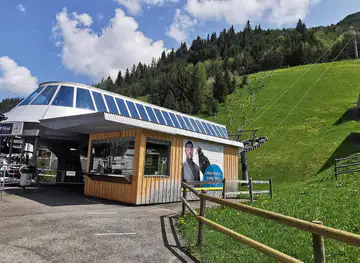
Gnalp Trail is a short but characterful hiking route in the mountain municipality of Triesenberg, Liechtenstein, linking the Gnalp area with the alpine settlement of Steg. Rather than being a remote wilderness expedition, it is a local mountain path through wooded slopes and open upland scenery, with views shaped by the steep Rhine Valley mountains and the higher ridges of the Liechtenstein Alps. Its appeal lies in the transition from settled hillside to quieter alpine terrain, where forest, pasture and mountain air replace the urban landscape of the Rhine Valley.Read more about Gnalp Trail
Gnalp, Steg and Triesenberg
Walking Character
When is the best time to visit Gnalp Trail?
Best: June–August · 23–25°C| Month | High (°C) | Rainfall (mm) |
|---|---|---|
| January | 1 | 60 |
| February | 2 | 50 |
| March | 9 | 40 |
| April | 13 | 40 |
| May | 18 | 50 |
| June (best) | 23 | 60 |
| July (best) | 25 | 70 |
| August (best) | 24 | 60 |
| September | 20 | 50 |
| October | 15 | 40 |
| November | 9 | 40 |
| December | 3 | 50 |
Getting to and around Gnalp Trail
How to get there
Transportation
Best attractions in Gnalp Trail
The principal attraction is the Gnalp–Steg walking connection itself, where a marked mountain path leads through woodland and changing views above Triesenberg. Gnalp offers a close look at Liechtenstein’s settled upland landscape, while Steg opens into a sheltered alpine basin used for walking and winter recreation. Around Triesenberg, visitors can explore the village’s Walser character and the mountain roads that connect it with higher pastures. The route also provides access to the wider network of paths towards the surrounding ridges and valleys, although these should be chosen according to ability, weather and current conditions. Clearings along the way create opportunities to look back towards the Rhine Valley, while the forested sections give the walk a quieter, more enclosed character. The nearby village of Malbun, reached separately from Steg, is a major mountain recreation centre in the wider Triesenberg area, but it is not part of the Gnalp Trail itself.
-
Tourist attraction
Bergbahnen Malbun AG
Experience alpine bliss at Bergbahnen Malbun AG: skiing, hiking, and breathtaking views in Liechtenstein's family-friendly mountain resort.
-
Farm
Lama- & Alpakahof Triesenberg
Experience the charm of Liechtenstein with llama and alpaca treks, stunning mountain views, and local farm products in Triesenberg.
-
Historical landmark
Red House, Vaduz
Discover the iconic Red House in Vaduz, a historic landmark with a striking red facade and charming vineyard setting.
-
Observation deck
Aussichtsturm Gaflei
A historic stone tower in Gaflei, Liechtenstein, offering panoramic views of the Rhine Valley and Alps, perfect for hikers and photographers.


Best landmarks in Gnalp Trail
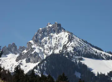
The Gnalp–Steg tunnel is the route’s most recognisable practical landmark, representing the modern engineering connection between Triesenberg’s settled slopes and the alpine basin of Steg. The wooded mountain corridor around Gnalp is itself significant as part of Liechtenstein’s inhabited cultural landscape, where forest, pasture and village access meet. Triesenberg’s parish church and village centre provide architectural and cultural reference points for the Walser municipality, while Steg’s compact settlement and surrounding basin mark the transition into higher mountain terrain. Farther away, the ridges above the route form the natural backdrop rather than discrete monuments, and their appearance changes markedly with season, cloud and snow. These features are best understood together: the trail is a passage through a landscape shaped by Alpine geology, mountain settlement and modern access.
-
Castle
Vaduz Castle
Explore Vaduz Castle, a historic gem in Liechtenstein, offering stunning views, rich history, and an enchanting experience in the heart of Europe.
-
Catholic cathedral
Kathedrale St. Florin
Discover the breathtaking St. Florin Cathedral in Vaduz, a stunning neo-Gothic masterpiece and a key cultural landmark of Liechtenstein.
-
Bridge
Alte Rheinbrücke
Discover the Alte Rheinbrücke, a stunning bridge offering a unique experience of walking between Switzerland and Liechtenstein amidst breathtaking natural beauty.
-
Free parking lot
Steg Parkplatz beim Gänglesee
Discover the beauty of Liechtenstein at Steg Parkplatz beim Gänglesee, your free parking haven for outdoor adventures and stunning mountain views.


Explore Gnalp Trail on the map
Plan your trip on one map. See where the top attractions, landmarks, restaurants and hotels are, and book hotels and experiences in a few clicks.
Best hotels in Gnalp Trail
Best restaurants in Gnalp Trail
Dining directly beside Gnalp Trail is limited, so visitors generally eat before or after walking in Triesenberg, Steg or other Liechtenstein settlements reached by road. The local food culture combines Alpine and Central European influences, with dairy products, bread, potatoes, seasonal produce and hearty dishes suited to mountain communities. In Triesenberg and Steg, visitors may find restaurants, cafés or accommodation-based dining, but opening patterns and seasonal availability should be checked rather than assumed. A packed lunch is sensible for a walk, particularly outside the main settlement areas. In the wider country, farm shops and village businesses can provide regional produce, while nearby Vaduz and the Rhine Valley offer a broader range of restaurants than the mountain villages.
-
 Restaurant
Hotel Turna Malbun
Experience comfort and breathtaking views at Hotel Turna Malbun, your ideal retreat in Liechtenstein's beautiful mountains.
-
Restaurant
Park Hotel Sonnenhof
Discover luxury dining and accommodation at Park Hotel Sonnenhof in Vaduz, Liechtenstein - where elegance meets exceptional service.
-
Restaurant
Berggasthaus Masescha
Experience authentic Liechtenstein cuisine at Berggasthaus Masescha while enjoying stunning views of the majestic alpine landscape.
-
Family-friendly
Sareis
Experience family-friendly dining at Sareis in Malbun - where delicious cuisine meets breathtaking alpine views.


Best bars in Gnalp Trail
Gnalp Trail has no nightlife scene of its own, and evenings in Gnalp and Steg are generally quiet after outdoor activities finish. The most characteristic options are the social atmosphere of a village inn, restaurant or accommodation venue in Triesenberg or Steg, where availability depends on the season and local opening arrangements. Visitors seeking a wider selection of bars can travel down to Vaduz or other larger communities in the Rhine Valley, although these are outside the immediate trail setting. The area is better suited to an early dinner, a calm drink and mountain views than to late-night entertainment, with winter and summer recreation shaping the rhythm of local evenings.
-
Restaurant
Berggasthaus Masescha
Experience exquisite local cuisine and breathtaking mountain views at Berggasthaus Masescha, a culinary treasure in Triesenberg, Liechtenstein.
-
Brasserie
Brasserie Burg
Experience exquisite dining at Brasserie Burg in Vaduz, where local flavors meet international cuisine in a cozy, welcoming atmosphere.
-
Restaurant
Scanaua Restaurant & Bar
Experience the rich flavors of Liechtenstein at Scanaua Restaurant & Bar, where local cuisine meets a vibrant dining atmosphere.
-
Bar
Esquire Bar.Bistro
Discover the sophisticated charm of Esquire Bar.Bistro in Vaduz, where exquisite cuisine meets a vibrant bar atmosphere for an unforgettable experience.


Best nightclubs in Gnalp Trail
Gnalp Trail has no nightlife scene of its own, and evenings in Gnalp and Steg are generally quiet after outdoor activities finish. The most characteristic options are the social atmosphere of a village inn, restaurant or accommodation venue in Triesenberg or Steg, where availability depends on the season and local opening arrangements. Visitors seeking a wider selection of bars can travel down to Vaduz or other larger communities in the Rhine Valley, although these are outside the immediate trail setting. The area is better suited to an early dinner, a calm drink and mountain views than to late-night entertainment, with winter and summer recreation shaping the rhythm of local evenings.
-
Bar
Esquire Bar.Bistro
Experience the vibrant atmosphere and delightful drinks at Esquire Bar.Bistro, a must-visit destination in Vaduz, Liechtenstein.
-
Bar
Zwei Bar
Experience the vibrant nightlife of Vaduz at Zwei Bar, a stylish hotspot offering craft cocktails and a lively atmosphere.
-
Bar
Take 5 Vaduz
Discover the nightlife of Triesen at Take 5 Vaduz, a vibrant bar offering delightful drinks and a lively atmosphere for an unforgettable experience.
-
Beer Garden
Lömagarta
Experience the lively atmosphere of Lömagarta, Vaduz's premier beer garden offering a diverse selection of local and international brews amidst beautiful surroundings.
Best shops in Gnalp Trail
Shopping opportunities on or immediately beside Gnalp Trail are very limited. The practical places to look for everyday supplies are Triesenberg and the larger communities in the Rhine Valley, while visitors may find regional food products, local crafts or small independent goods through village businesses and farm-related outlets rather than a dedicated shopping district. Triesenberg’s Walser identity gives locally produced food, traditional objects and cultural material a stronger sense of place than generic souvenirs, although stock and opening arrangements vary. Vaduz offers the broadest retail choice in the country, including specialist shops and Liechtenstein-themed gifts, but it lies away from the trail. Carry water, snacks and walking essentials from a larger settlement if the route is being visited outside normal business hours.
-
Farm
Lama- & Alpakahof Triesenberg
Discover the charm of Lama- & Alpakahof Triesenberg, where friendly llamas and alpacas await amidst breathtaking mountain views.
-
Winery
Cellars of the Prince of Liechtenstein
Experience the rich tradition of winemaking at the Cellars of the Prince of Liechtenstein, where every bottle tells a story.
-
Grocery store
Ospelt Metzgerei/Genussmarkt
Discover the flavors of Liechtenstein at Ospelt Metzgerei/Genussmarkt, a premier grocery store in Schaan offering local meats, cheeses, and gourmet delights.
-
Bakery
Balu Bäckerei Konditorei
Explore the delightful flavors of Liechtenstein at Balu Bäckerei Konditorei, where every pastry tells a story of tradition and taste.


Get your free copy of our complete guide to Gnalp Trail, delivered straight to you.
Everything on this page, from attractions and restaurants to essentials and local phrases, in one PDF you can read offline, print or share.
Already have an account? Sign in
Your Gnalp Trail guide is ready.
We'll send it to · Not you? Sign out

Getting your guide ready…
We are putting together a fresh copy of the Gnalp Trail guide. This can take up to a minute.
This can take a few moments. If your browser asks, choose Allow so the download can start. You'll find the guide in your Downloads folder.
Nothing happened? Download it again
Sorry, the guide is taking longer than usual. Please try again in a minute, or get it by email instead.
Gnalp Trail essentials
Currency and Payment
Safety
Emergency Situations
Do's and Don'ts
Local Tips
From Eve
Local phrases worth knowing
You don't need to get them perfect. A few words go a long way, and locals appreciate the effort.
Basics
| English | Local | Say it |
|---|---|---|
| Hello | Hallo | [ha-lo] |
| Goodbye | Adieu | [a-dyuh] |
| Yes | Ja | [yah] |
| No | Nein | [nine] |
| Please/You're welcome | Bitte | [bit-teh] |
| Thank you | Danke | [dahn-keh] |
| Excuse me/Sorry | Entschuldigung | [ent-shool-dee-gung] |
| How are you? | Wie geht es dir? | [vee get es deer] |
| Fine. And you? | Gut. Und du? | [goot oond doo] |
| Do you speak English? | Sprichst du Englisch? | [shprikhst doo eng-lish] |
| I don't understand | Ich verstehe nicht | [ikh fer-shteh-eh nikt] |
Eating & Drinking
| English | Local | Say it |
|---|---|---|
| I'd like to see the menu, please | Ich würde gerne die Speisekarte sehen, bitte | [ikh vur-deh gehr-neh dee shpi-ze-kahr-teh zeh-en, bit-teh] |
| I don't eat meat | Ich esse kein Fleisch | [ikh ess-eh kine fli-sh] |
| Cheers! | Prost! | [prohst] |
| I would like to pay, please | Ich möchte bitte zahlen | [ikh murkhte bit-teh tsah-len] |
Emergencies
| English | Local | Say it |
|---|---|---|
| Help! | Hilfe! | [hil-feh] |
| Go away! | Geh weg! | [geh vekh] |
| Call the Police! | Rufen Sie die Polizei! | [roo-fen zee dee poh-lee-tsay] |
| Call a doctor! | Rufen Sie einen Arzt! | [roo-fen zee i-nen artsht] |
| I'm lost | Ich habe mich verirrt | [ikh hah-beh meekh feh-reert] |
| I'm ill | Ich bin krank | [ikh been krunk] |
Shopping
| English | Local | Say it |
|---|---|---|
| I'd like to buy... | Ich möchte ... kaufen | [ikh murkhte ... kow-fen] |
| I'm just looking | Ich schaue nur | [ikh shou-eh noor] |
| How much is it? | Wie viel kostet es? | [vee feel kohs-teht es] |
| That's too expensive | Das ist zu teuer | [dahs ist tsoo toy-er] |
| Can you lower the price? | Kannst du den Preis senken? | [kahnst doo den preis zehn-ken] |
Time & Numbers
| English | Local | Say it |
|---|---|---|
| What time is it? | Wie spät ist es? | [vee shpet ist es] |
| It's one o'clock | Es ist ein Uhr | [es ist iyn oor] |
| Half past (10) | Halb zehn | [halb tsehn] |
| Morning | Morgen | [mor-gen] |
| Afternoon | Nachmittag | [nahk-mit-tahg] |
| Evening | Abend | [ah-bent] |
| Yesterday | Gestern | [gehs-tern] |
| Today | Heute | [hoy-teh] |
| Tomorrow | Morgen | [mor-gen] |
| 1 | Eins | [iyns] |
| 2 | Zwei | [tsvai] |
| 3 | Drei | [dry] |
| 4 | Vier | [feer] |
| 5 | Fünf | [foonf] |
| 6 | Sechs | [zeks] |
| 7 | Sieben | [zee-ben] |
| 8 | Acht | [ahkt] |
| 9 | Neun | [noyn] |
| 10 | Zehn | [tsehn] |
Transport & Directions
| English | Local | Say it |
|---|---|---|
| Where's a/the...? | Wo ist ein/der...? | [vo ist iyn/dehr] |
| What's the address? | Was ist die Adresse? | [vas ist dee ah-drehs-seh] |
| Can you show me (on the map)? | Können Sie mir zeigen (auf der Karte)? | [ker-nen zee meer tsai-gen (owf dehr kar-teh)] |
| When's the next (bus)? | Wann kommt der nächste (Bus)? | [vahn kohmt dehr nehk-steh (boos)] |
| A ticket (to ....) | Eine Fahrkarte (nach ...) | [iyn-eh fahr-kahr-teh (nahkh ...)] |
History of Gnalp Trail
A Landscape Shaped by the Alps
The Gnalp Trail crosses a landscape formed by the eastern Alpine mountains above Liechtenstein’s Rhine Valley. Steep slopes, glacially influenced valleys and upland basins have constrained settlement and encouraged a long association with pasture, forestry and seasonal mountain use. The route’s wooded sections and open ground reflect this meeting of natural terrain and managed landscape. Although the trail is experienced as a walking route today, its setting belongs to a much older pattern in which movement between valley settlements and higher grazing areas was determined by topography, weather and the agricultural calendar.
Walser Settlement at Triesenberg
Triesenberg is closely associated with Walser settlers, German-speaking Alpine communities who established themselves in high valleys and mountain regions during the medieval period. Their settlement helped shape the cultural character of the municipality, including local speech, customs and patterns of scattered mountain habitation. Gnalp stands within this historically inhabited upland rather than an empty natural zone. The relationship between Triesenberg, Gnalp and Steg reflects the way mountain communities used several levels of the landscape: village slopes for settlement and agriculture, and higher terrain for forestry, pasture and seasonal work.
The Route to Steg
For centuries, movement towards the interior mountain basin around Steg depended on narrow routes over difficult terrain. The modern road connection, including the Gnalp–Steg tunnel, changed access between Triesenberg and the alpine settlement while reducing reliance on exposed mountain tracks. Walking routes such as the Gnalp Trail preserve a slower connection with this terrain, allowing visitors to experience the wooded approach and the change in elevation away from the settled valley slopes. Steg subsequently developed as an important base for mountain recreation in Liechtenstein.
Modern Recreation and Landscape Care
In the modern period, Triesenberg and Steg have combined everyday residential life with tourism and outdoor recreation. Marked paths, winter sports facilities around Steg and access roads have made the high country more approachable, while forestry, farming and conservation continue to influence the landscape. The Gnalp Trail is therefore part of a living cultural landscape rather than a preserved historical corridor. Visitors encounter working pasture, managed woodland and public paths whose condition and accessibility can change with the season.
Gnalp Trail in Photos
Browse through our photo collection highlighting the charm and character of the destination.
Cities in Gnalp Trail
The towns and cities of Gnalp Trail, and the easiest places to base yourself.
-

-
-


Swipe for more cities
Neighbouring destination travel guides
The closest destinations to Gnalp Trail, if you have time for more than one.
-
-

-

-

-


Swipe for more destinations
Explore more

Explore more of Vaduz Region
Explore the Vaduz Region for Liechtenstein’s museums, Alpine viewpoints, princely heritage, vineyards and Walser mountain culture.
Explore Vaduz Region
Explore more of Liechtenstein
Discover the charm of Liechtenstein, a tiny Alpine principality offering medieval castles, stunning hiking trails, and a rich cultural heritage in the heart of Europe.
Explore Liechtenstein