Mohawk Trail · Travel guide · Updated 2026

Majestic Mohawk Trail: A Scenic Adventure in Massachusetts

Discover the Mohawk Trail: A Scenic Drive Through History and Nature in Massachusetts

The Mohawk Trail is a historic and scenic route in the heart of Massachusetts that offers a captivating blend of natural beauty, cultural heritage, and outdoor adventure. Stretching over 63 miles from the Massachusetts-New York border to the Connecticut River, this trail is one of the most picturesque drives in New England. Originally a Native American trade route, the Mohawk Trail is now a favorite destination for tourists seeking stunning views and a taste of history. As you drive along the winding roads, you'll encounter charming small towns, lush forests, and breathtaking mountain vistas. The trail is particularly famous for its vibrant fall foliage, which transforms the landscape into a tapestry of brilliant colors every autumn. Outdoor enthusiasts will find plenty to do along the Mohawk Trail. There are numerous hiking trails, such as the popular Hairpin Turn Overlook and Mount Greylock, the highest peak in Massachusetts. The area is also ideal for camping, fishing, and wildlife watching. Along the way, you can explore quaint shops, art galleries, and historic landmarks that provide a glimpse into the region's rich past.

Explore the guide

What are you looking for in Mohawk Trail?

Jump straight into the city guide by the kind of discovery you want first.

When is the best time to go to Mohawk Trail?

Weather at a glance

Use the monthly temperature and precipitation trends to compare typical conditions across the year before planning city walks, museum days, and riverside exploring.

Temperature

°C

Precipitation

mm
Warmest monthsJul–Aug
Longest daylightMay–Jul
Driest periodJan–Feb

Explore places in Mohawk Trail

    See all →

    Popular Experiences in Mohawk Trail

    Top-rated options near you

    Mobile App
    Get the app

    Your all‑in‑one travel companion app

    Explore expert travel guides, compare and book tours, experiences, hotels, and more—all from the palm of your hand. Download now for seamless trip planning wherever your wanderlust takes you.

    Popular Hotels in Mohawk Trail

    Top-rated options near you

    Practical planning

    Mohawk Trail Essentials

    Core city planning details in the same structured guide format used across the Country/Region page language.

    How to Get There

    The Mohawk Trail is located in the northwestern part of Massachusetts. The nearest major airport is Boston Logan International Airport, approximately 130 miles away. From Boston, you can rent a car and drive to the Mohawk Trail, which typically takes about 2.5 to 3 hours. Alternatively, you can take a bus or train to nearby towns such as North Adams or Greenfield, and then use local transportation options to reach the trail.

    Transportation

    While the Mohawk Trail is best explored by car due to its scenic byway nature, there are also options for biking and hiking. Car rentals are available at major airports and in nearby cities. Public transportation is limited, but local buses and taxis can be found in towns along the trail. For those looking to cycle, bike rentals are available in some towns, and there are dedicated bike paths for safer travel.

    Currency and Payment

    The official currency in the United States is the US Dollar (USD). Credit and debit cards are widely accepted in most establishments along the Mohawk Trail, including restaurants, hotels, and shops. However, it is advisable to carry some cash, especially for smaller businesses and rural areas. ATMs are available in most towns along the trail.

    Safety

    The Mohawk Trail is generally a safe destination for tourists. However, as with any travel destination, it is important to take standard precautions. Avoid leaving valuables in your car unattended, especially in remote areas. There are no specific high-crime areas targeting tourists, but it is always best to stay vigilant and aware of your surroundings.

    Emergency Situations

    In case of emergency, dial 911 for immediate assistance. Local police stations and medical facilities are available in towns along the Mohawk Trail. It is recommended to have travel insurance that covers medical emergencies. For minor health issues, there are pharmacies in most towns where you can purchase over-the-counter medications.

    Do's and Don'ts

    Fashion: Do dress comfortably for outdoor activities, including hiking and walking. Layers are advisable due to changing weather conditions. Religion: Do respect local customs and traditions. Some areas may have historical churches or religious sites. Public Transport: Public transport is limited, so do plan ahead if you are not driving. Greetings: A friendly wave or handshake is common. Eating & Drinking: Do try local delicacies and regional cuisine. Don’t litter; always carry your trash with you until you find a proper disposal bin.

    Local Tips

    To experience the Mohawk Trail like a local, visit during the fall when the foliage is at its peak. Stop by roadside farm stands for fresh produce and local crafts. Engage with locals in small towns to learn about the area's history and culture. Don't miss natural attractions like Mount Greylock, the highest peak in Massachusetts, and the Bridge of Flowers in Shelburne Falls. Also, take advantage of the numerous hiking trails and scenic overlooks for breathtaking views.

    History of Mohawk Trail

    Follow the city from Roman Londinium to its modern global identity through landmark moments that still shape the visitor experience.

    Origins and Indigenous Significance

    The Mohawk Trail, originally a Native American trade route, has been used for centuries by various tribes, including the Mohawk and Pocumtuck peoples. This ancient path facilitated the exchange of goods and culture between tribes in the Hudson River Valley and the Connecticut River Valley. The trail was integral to the social and economic fabric of the region long before European settlers arrived.

    Colonial Era and European Settlement

    During the 17th century, European settlers began to utilize the Mohawk Trail for trade and military purposes. The trail played a critical role during King Philip's War (1675-1676), when colonial and Native American forces clashed over territory and resources. The route provided a strategic link between settlements, enabling the movement of troops and supplies.

    Transforming into a Scenic Highway

    In the early 20th century, the Mohawk Trail was transformed into one of the first scenic highways in the United States. Officially opened in 1914, the modern Mohawk Trail spanned more than 60 miles, from the Massachusetts-New York border to the Connecticut River Valley. The project aimed to promote automobile tourism and highlight the natural beauty of the Berkshires.

    Economic and Cultural Impact

    The development of the Mohawk Trail as a scenic highway brought significant economic benefits to the region. Towns along the route, such as North Adams and Shelburne Falls, saw an influx of tourists, leading to the growth of local businesses, including inns, restaurants, and souvenir shops. The trail also became a cultural icon, celebrated in postcards, travel literature, and local lore.

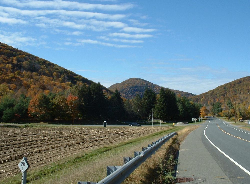
    Modern Day Attractions

    Today, the Mohawk Trail is renowned for its breathtaking vistas, especially during the fall foliage season. Key attractions along the route include the iconic Hairpin Turn, the Bridge of Flowers in Shelburne Falls, and the Hoosac Range. The trail also offers numerous hiking opportunities, with several state parks and recreational areas providing access to the region's natural wonders.

    Cultural Festivals and Events

    The Mohawk Trail region hosts a variety of cultural festivals and events that celebrate its rich history and vibrant community. Notable events include the Fall Foliage Festival, which attracts visitors from all over to witness the stunning autumn colors, and the Mohawk Trail Concerts, which offer classical music performances in historic venues. These events highlight the enduring cultural significance of the trail.

    Preservation Efforts

    Efforts to preserve the historical and natural integrity of the Mohawk Trail have been ongoing for decades. Various organizations and local governments have worked together to maintain the scenic quality and historical landmarks along the route. Preservation initiatives include the protection of natural habitats, the restoration of historic sites, and the promotion of sustainable tourism practices.

    Phrasebook

    Local Phrases about Mohawk Trail

    Browse practical local phrases by situation. Each group opens only when needed, keeping the guide tidy while preserving the full phrase set.

    6 phrase groups English + pronunciation
    Basics
    • HelloShe:kon
      [shay-gon]
    • GoodbyeSewakwe:kon
      [seh-wah-gway-gon]
    • YesEa
      [ay-ah]
    • NoNia
      [knee-ah]
    • Please/You're welcomeNiawenhkó:wa
      [knee-ah-wen-koh-wah]
    • Thank youNia:wen
      [knee-ah-wen]
    • Excuse me/SorryOnenh
      [oh-nen]
    • How are you?Kwe kwe
      [kweh-kweh]
    • Fine. And you?Skaononh
      [skah-oh-nonh]
    • Do you speak English?Oⁿkwariⁿ ne onwe ne raonnyo?
      [on-wah-ree-on-nay-nay-rah-own-nyoh]
    • I don't understandRatitiwennón:ni
      [rah-dee-dee-wen-nohn-nee]
    Eating & Drinking
    • I'd like to see the menu, pleaseKio’nikonhra
      [key-oh-nee-gon-hrah]
    • I don't eat meatNia:wen ohneka
      [knee-ah-wen ohn-eh-kah]
    • Cheers!O:nenh
      [oh-nen]
    • I would like to pay, pleaseKio’nikonhra
      [key-oh-nee-gon-hrah]
    Emergencies
    • Help!Kweh
      [kweh]
    • Go away!Kweh
      [kweh]
    • Call the Police!Kweh
      [kweh]
    • Call a doctor!Kweh
      [kweh]
    • I'm lostNia:wen onkwa’nikòn:ra
      [knee-ah-wen ohn-kwah-nee-gon-rah]
    • I'm illNia:wen onkwa’nikòn:ra
      [knee-ah-wen ohn-kwah-nee-gon-rah]
    Shopping
    • I'd like to buy...Kio’nikonhra
      [key-oh-nee-gon-hrah]
    • I'm just lookingNia:wen onkwa’nikòn:ra
      [knee-ah-wen ohn-kwah-nee-gon-rah]
    • How much is it?Tiokaristha
      [dee-oh-gah-ree-sthah]
    • That's too expensiveRasénhes
      [rah-sehn-hehs]
    • Can you lower the price?Rasénhes
      [rah-sehn-hehs]
    Time & Numbers
    • What time is it?Ronwaia’tanónhsera
      [rohn-wah-yah-tah-nonh-seh-rah]
    • It's one o'clockKanónhsa’
      [gah-nohn-hsah]
    • Half past (10)Nia:wen onkwa’nikòn:ra
      [knee-ah-wen ohn-kwah-nee-gon-rah]
    • MorningNia:wen onkwa’nikòn:ra
      [knee-ah-wen ohn-kwah-nee-gon-rah]
    • AfternoonNia:wen onkwa’nikòn:ra
      [knee-ah-wen ohn-kwah-nee-gon-rah]
    • EveningNia:wen onkwa’nikòn:ra
      [knee-ah-wen ohn-kwah-nee-gon-rah]
    • YesterdayKanónhsa’
      [gah-nohn-hsah]
    • TodayKanónhsa’
      [gah-nohn-hsah]
    • TomorrowKanónhsa’
      [gah-nohn-hsah]
    • 1Kanónhsa’
      [gah-nohn-hsah]
    • 2Kanónhsa’
      [gah-nohn-hsah]
    • 3Kanónhsa’
      [gah-nohn-hsah]
    • 4Kanónhsa’
      [gah-nohn-hsah]
    • 5Kanónhsa’
      [gah-nohn-hsah]
    • 6Kanónhsa’
      [gah-nohn-hsah]
    • 7Kanónhsa’
      [gah-nohn-hsah]
    • 8Kanónhsa’
      [gah-nohn-hsah]
    • 9Kanónhsa’
      [gah-nohn-hsah]
    • 10Kanónhsa’
      [gah-nohn-hsah]
    Transport & Directions
    • Where's a/the...?Kanónhsa’
      [gah-nohn-hsah]
    • What's the address?Kanónhsa’
      [gah-nohn-hsah]
    • Can you show me (on the map)?Kanónhsa’
      [gah-nohn-hsah]
    • When's the next (bus)?Kanónhsa’
      [gah-nohn-hsah]
    • A ticket (to ....)Kanónhsa’
      [gah-nohn-hsah]

    Explore Mohawk Trail in Photos

    A quick visual tour through classic views, riverside landmarks, royal streets, and skyline moments.

    File:Charlemont-Mohawk Trail.JPG - Wikimedia Commons
    Free Images : forest, wilderness, walking, roadsign, street sign, road  sign, roadsigns, woodland, habitat, natural environment, hairpin turn, mohawk  trail 3072x2304 - - 1134539 - Free stock photos - PxHere
    File:Bridge of Flowers, Shelburne Falls.jpg - Wikimedia Commons
    File:2019-09-22 09 51 30 360-degree stitched panorama from the top of the  Veterans War Memorial Tower on the summit of Mount Greylock in Adams,  Berkshire County, Massachusetts.jpg - Wikimedia Commons
    Twinkle, twinkle! 16 Awesome Public Lands for Stargazing | U.S. Department  of the Interior
    File:Near east entrance of Hoosac Tunnel.jpg - Wikimedia Commons
    File:Whitcomb Summit Lookout Tower and Motel, Florida MA.jpg - Wikimedia  Commons

    Select Currency

    Choose the currency you want prices to display in.